Geographic Subject: Perry County (Ind.), Geographic Subject: Spencer County (Ind.), Topical Subject: Coal, and Geographic Subject: Warrick County (Ind.)
Creator:
Ashley, Geo. H. (George Hall), 1866-1951, Kindle, E. M. (Edward Martin), 1869-1940, and Price, J. A.
Publisher:
Indiana. Department of Geology and Natural Resources
Date Created:
1898
Identifier:
VAC3073-M-01185
Genre:
Geological maps
Geographic Location:
Coordinates: W0872823 W0862942 N0381446 N0374639
Related URL:
Catalog URL: https://iucat.iu.edu/catalog/9160352
Abstract:
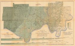
By George H. Ashley, assistant geologist, Department of Geology and Natural Resources of Indiana, W.S. Blatchley, state geologist , geology by G.H. Ashley, J...
Call Number:
G4093.W4H9 1898 .A8
Caption:
Imprint: Indianapolis : Burford, [1899] and Imprint: [Indianapolis, Ind.] : Dept. of Geology and Natural Resources of Indiana, [1899]
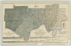
Relief shown by spot heights. Includes map showing coal locations and features, and quarries as well as vertical cross-sections through center of Township 3 ...
Call Number:
G4093.P4H9 1898 .A84
Caption:
Imprint: Indianapolis : Burford, [1899]
Physical Description:
Dimensions: 48 x 78 cm and Scale: Approximately 1:126,720. 1 inch = 2 miles. Vertical scale approximately 1:4,800. 1 inch = 400 feet
Alternate Identifier:
Title Control Number: a18175917 and Alternate ID: 390726IP
Relief shown by profile. Shows two geological cross-sections. "Based upon Congressional land surveys, field work of Ind. Geol. Survey, county atlases.&q...
Call Number:
G4093.W4H9 1898 .A8x
Caption:
Imprint: Indianapolis : Burford, [1899] and Imprint: [Indianapolis, Ind.] : Dept. of Geology and Natural Resources of Indiana, [1899]
Physical Description:
Scale: Approximately 1:126,720. 2 miles = 1 inch. Vertical scale approximately 1:4,800. 400 feet = 1 inch and Dimensions: 49 x 77 cm
Alternate Identifier:
Alternate ID: 390726IP and Title Control Number: a16848969
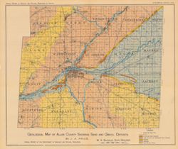
Shows shale locations, quarries, gas wells, schools, churches, and cemeteries. Detached from: A report upon the Waldron shale and its horizon ... / J.A. Pric...
Call Number:
G4091.C5 1899 .P7
Caption:
Imprint: Indianapolis : Indiana Dept. of Geology and Natural Resources, [1900] and Imprint: Indianapolis, Ind. : Wm. B. Burford, Lith., [1900]
Physical Description:
Dimensions: 40 x 33 cm and Scale: Approximately 1:126,720. 2 miles = 1 inch
Alternate Identifier:
Alternate ID: 390726IP and Title Control Number: a18272889
Shows roads, gravel and sand deposits, lake bottoms and abandoned river channels, beaches, moraines, and inter-moranic plains. Also shows cemeteries and chur...
Call Number:
G4093.A4H5 1905 .P7
Caption:
Imprint: [Indianapolis] : [Indiana Department of Geology and Natural Resources], [1906]
Physical Description:
Dimensions: 38 x 45 cm and Scale: Approximately 1:126,720. 2 miles = 1 inch
Alternate Identifier:
Alternate ID: 390726IP and Title Control Number: a18298916


![Map of the distribution of the Waldron shale in Decatur, Rush, Shelby, and Bartholomew counties, [Indiana]](https://iiif.uits.iu.edu/iiif/2/hh63tz71g%2Ffiles%2F9928330d-568f-4904-a59c-ed2846292533/full/250,/0/default.jpg)