
Search Constraints
You searched for:
Campus
IUB
Remove constraint Campus: IUB
Date Created
1912
Remove constraint Date Created: 1912
Holding Location
B-WELLS
Remove constraint Holding Location: B-WELLS
Pages
0-99 pages
Remove constraint Pages: 0-99 pages
« Previous |
1 - 10 of 32
|
Next »
Search Results
-
- Description:
- 1910
- Subject:
- Topical Subject: Soviet Union, Geographic Subject: Rybachiy, and Topical Subject: Maps
- Publisher:
- Генеральный штаб РККА
- Language:
- Russian
- Date Created:
- 1912
- Identifier:
- VAC9619-003905
- Genre:
- Topographic Maps and Military Maps
- Geographic Location:
- Coordinates: 55, 20.5, 55.333, 21
- Related URL:
- Catalog URL: https://iucat.iu.edu/catalog/5020129 and Download GeoTIFF: https://drive.google.com/file/d/1AKV0P3Ci5PuDiPb76mBQX1DPGLCl2iQI/view?usp=sharing
- Abstract:
- Modern area represented: Rybachiy, Kaliningrad, Russia
- Call Number:
- G7000 s100 .S7 sheet N-34-30
- City:
- Росситтен (Rossitten)
- Copyright Holder:
- No Copyright - United States
- State/Province:
- Кенигсбергская провинция (Königsberg province) and Восточная Пруссия (East Prussia)
- Physical Description:
- Scale: 1:100,000
- Persistent URL:
- http://purl.dlib.indiana.edu/iudl/images/VAC9619/VAC9619-003905
- Provenance:
- DMA Topographic Center, Army Map Service Library, OMAHA
-
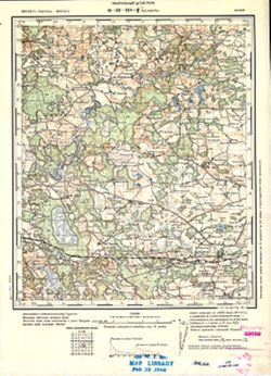
- Description:
- 1894
- Subject:
- Topical Subject: Maps, Topical Subject: Soviet Union, and Geographic Subject: Šilutė
- Publisher:
- Управление военных топографов РККА
- Language:
- Russian
- Date Created:
- 1912
- Identifier:
- VAC9619-003899
- Genre:
- Military Maps and Topographic Maps
- Geographic Location:
- Coordinates: 55.333, 21, 55.667, 21.5
- Related URL:
- Download GeoTIFF: https://drive.google.com/file/d/1IHHnxhC0ySuJTtWCJ48iYBtPYIwl60II/view?usp=sharing and Catalog URL: https://iucat.iu.edu/catalog/5020129
- Abstract:
- Modern area represented: Šilutė, Klaipėda County, Lithuania
- Call Number:
- G7000 s100 .S7 sheet N-34-19
- City:
- Шилутэ (Šilutė)
- Copyright Holder:
- No Copyright - United States
- Country:
- Литва (Lithuania)
- Physical Description:
- Scale: 1:100,000
- Persistent URL:
- http://purl.dlib.indiana.edu/iudl/images/VAC9619/VAC9619-003899
- Provenance:
- Army Map Service Library, Library of Congress G & M Division, Geographic Names Branch
-
- Description:
- 1874
- Subject:
- Geographic Subject: Biksti, Topical Subject: Soviet Union, and Topical Subject: Maps
- Publisher:
- Генеральный штаб РККА
- Language:
- Russian
- Date Created:
- 1912
- Identifier:
- VAC9619-001731
- Genre:
- Military Maps and Topographic Maps
- Geographic Location:
- Coordinates: 56.667, 22.75, 56.833, 23
- Related URL:
- Catalog URL: http://iucat.iu.edu/catalog/5020131 and Download GeoTIFF: https://drive.google.com/open?id=17LPaPIeQR_3_z3mGMF__yzRcPqrF8mZ3
- Abstract:
- Modern area represented: Biksti, Zemgale region, Latvia
- Call Number:
- G7000 s50 .S68 sheet O-34-118-D
- City:
- Мз. Биксты (Biksti)
- Copyright Holder:
- No Copyright - United States
- Country:
- Латвия (Latvia)
- Physical Description:
- Scale: 1:50,000
- Persistent URL:
- http://purl.dlib.indiana.edu/iudl/images/VAC9619/VAC9619-001731
- Provenance:
- M. I. Map Library, GS, RA
-
- Description:
- 1874
- Subject:
- Geographic Subject: Sabile, Topical Subject: Soviet Union, and Topical Subject: Maps
- Publisher:
- Генеральный штаб РККА
- Language:
- Russian
- Date Created:
- 1912
- Identifier:
- VAC9619-001727
- Genre:
- Military Maps and Topographic Maps
- Geographic Location:
- Coordinates: 57, 22.5, 57.167, 22.75
- Related URL:
- Download GeoTIFF: https://drive.google.com/open?id=1nSBX-fo739OpGN33xwhMkF5J_gWjjpwg and Catalog URL: http://iucat.iu.edu/catalog/5020131
- Abstract:
- Modern area represented: Sabile, Talsi municipality, Latvia
- Call Number:
- G7000 s50 .S68 sheet O-34-106-C
- City:
- Сабиле (Sabile)
- Copyright Holder:
- No Copyright - United States
- Country:
- Латвия (Latvia)
- Physical Description:
- Scale: 1:50,000
- Persistent URL:
- http://purl.dlib.indiana.edu/iudl/images/VAC9619/VAC9619-001727
- Provenance:
- M. I. Map Library, Atlasblatt, GS, RA, Library of Congress Geography & Map Division
-
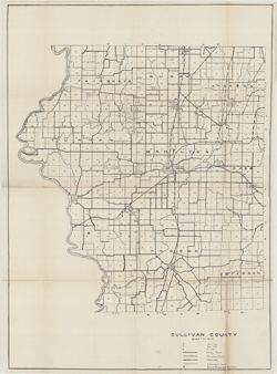
- Subject:
- Topical Subject: Soils, Geographic Subject: Sullivan County (Ind.), Topical Subject: IGS Annual Reports, and Topical Subject: Soil surveys
- Creator:
- Shannon, C. W. (Charles William), 1879-1934 and Shannon, M. E.
- Publisher:
- Indiana. Department of Geology and Natural Resources
- Date Created:
- 1912
- Identifier:
- VAC3073-M-01483
- Genre:
- Thematic maps
- Geographic Location:
- Coordinates: W0873845 W0871422 N0391540 N0385413
- Related URL:
- Catalog URL: https://iucat.iu.edu/catalog/18307850
- Abstract:
- Shows soil types, earth and improved public roads, railroads, schools, cemeteries, churches, and coal mines. Detached from: Soil survey of Clay, Knox, Sul...
- Call Number:
- G4093.S8J3 1911 .S5
- Caption:
- Imprint: [Indianapolis] : [Department of Geology and Natural Resources, Indiana], [1912]
- Physical Description:
- Scale: Approximately 1:63,360 and Dimensions: on sheet 64 x 59 cm
- Alternate Identifier:
- Alternate ID: 390726IP and Title Control Number: a18307850
- Persistent URL:
- https://purl.dlib.indiana.edu/iudl/images/VAC3073/VAC3073-M-01483
- Provenance:
- 36th Annual Report (1911) / Indiana. Department of Geology and Natural Resources.
-
![Indiana-Kentucky Owensboro quadrangle [1912 reprint]](https://iiif.uits.iu.edu/iiif/2/6d571071n%2Ffiles%2Fe60c13e2-5bbf-4e54-9481-ed8c9ad1c038/full/250,/0/default.jpg)
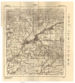
- Subject:
- Geographic Subject: Spencer County (Ind.), Geographic Subject: Daviess County (Ky.), and Geographic Subject: Warrick County (Ind.)
- Creator:
- Geological Survey (U.S.), Cooke, Chas. E. (Charles E.), Renshawe, John H., and Hawkins, Geo. T. (George T.)
- Publisher:
- Geological Survey (U.S.)
- Date Created:
- 1912
- Identifier:
- VAC3073-M-01373
- Genre:
- 15 minute topographic maps, Topographic maps, and Quadrangle maps
- Geographic Location:
- Coordinates: W0871500 W0870000 N0380000 N0374500
- Related URL:
- Catalog URL: https://iucat.iu.edu/catalog/18413576
- Abstract:
- John H. Renshaw, geographer in charge , control by George T. Hawkins , topography by Chas. E. Cooke. Filing title: Owensboro, Ind.-Ky. Edition of Nov. 1901. ...
- Call Number:
- G4090 s62 .G4 Owensboro 1901 rep 1912
- Caption:
- Imprint: Washington, D.C. : The Survey, 1912.
- Physical Description:
- Scale: 1:62,500 and Dimensions: 45 x 42 cm or smaller
- Alternate Identifier:
- Title Control Number: a18413576
- Persistent URL:
- https://purl.dlib.indiana.edu/iudl/images/VAC3073/VAC3073-M-01373
- Provenance:
- Part of Geological Survey (U.S.). Indiana 1:62,500.
-
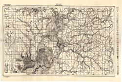
- Subject:
- Geographic Subject: Montgomery County (Ind.), Topical Subject: Mines and mineral resources, Topical Subject: Soils, and Topical Subject: Geology
- Creator:
- Jones, Grove B., 1877-
- Publisher:
- United States. Bureau of Soils
- Date Created:
- 1912
- Identifier:
- VAC3073-M-01186
- Genre:
- Thematic maps
- Geographic Location:
- Coordinates: W0870600 W0864200 N0401300 N0395200
- Related URL:
- Catalog URL: https://iucat.iu.edu/catalog/4022271
- Abstract:
- Shows soil types classification by colors and symbols. "Field Operations, Bureau of Soils, 1912." A. "Hoen & co. Lith. Baltimore, Md."
- Call Number:
- G4093.M8J3 1912 .J66
- Caption:
- Imprint: [Washington, D.C.?] : The Bureau, [1912?]
- Physical Description:
- Scale: 1:63,360 and Dimensions: 44 x 50 cm
- Persistent URL:
- https://purl.dlib.indiana.edu/iudl/images/VAC3073/VAC3073-M-01186
- Provenance:
- 37th Annual Report (1912) / Indiana. Department of Geology and Natural Resources.
-
- Subject:
- Geographic Subject: Greene County (Ind.) and Topical Subject: Soils
- Creator:
- Tharp, W. E. (William Edgar)
- Publisher:
- Indiana. Department of Geology and Natural Resources
- Date Created:
- 1912
- Identifier:
- VAC3073-M-01159
- Genre:
- Thematic maps
- Geographic Location:
- Coordinates: W0871427 W0864055 N0391018 N0385408
- Related URL:
- Catalog URL: https://iucat.iu.edu/catalog/16151513
- Abstract:
- Detached from: Soil survey of Greene County (1901) / by W. E. Tharp and Charles J. Mann, of the U. S. Bureau of Soils. In Thirty-sixth annual report of Depar...
- Call Number:
- G4093.G7J3 1906 .T5
- Caption:
- Imprint: [Indianapolis] : State of Indiana, Department of Geology, [1912] [Indianapolis] : [Wm. B. Burford], [1912]
- Physical Description:
- Dimensions: 35 x 52 cm and Scale: 1:80,000
- Alternate Identifier:
- Title Control Number: a16151513 and Alternate ID: 390726IP
- Persistent URL:
- https://purl.dlib.indiana.edu/iudl/images/VAC3073/VAC3073-M-01159
- Provenance:
- 36th Annual Report (1911) / Indiana. Department of Geology and Natural Resources.
-
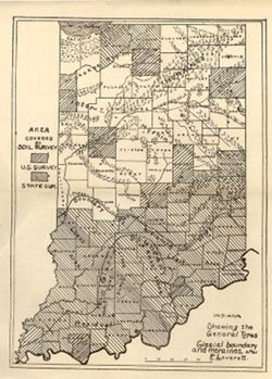
- Subject:
- Topical Subject: Soil surveys, Geographic Subject: Indiana, Topical Subject: IGS Annual Reports, Topical Subject: Moraines, and Topical Subject: Glacial epoch
- Publisher:
- Indiana. Department of Geology and Natural Resources
- Date Created:
- 1912
- Identifier:
- VAC3073-M-01144
- Genre:
- Thematic maps and Index maps
- Geographic Location:
- Coordinates: W0880500 W0844700 N0414500 N0374600
- Related URL:
- Catalog URL: https://iucat.iu.edu/catalog/18307837
- Abstract:
- Shows counties covered by a U.S. soil survey or a state soil survey. Detached from: Glaciation and soils / Edward Barrett. In Thirty-sixth annual report o...
- Call Number:
- G4091.C38 1911 .I5
- Caption:
- Imprint: [Indianapolis] : [Department of Geology and Natural Resources, Indiana], [1912]
- Physical Description:
- Scale: Approximately 1:1,750,000 and Dimensions: 24 x 18 cm
- Alternate Identifier:
- Alternate ID: 390726IP and Title Control Number: a18307837
- Persistent URL:
- https://purl.dlib.indiana.edu/iudl/images/VAC3073/VAC3073-M-01144
- Provenance:
- 36th Annual Report (1911) / Indiana. Department of Geology and Natural Resources.
-
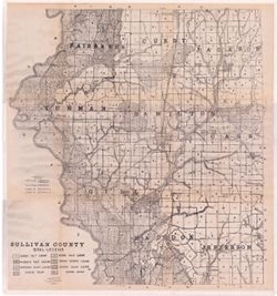
- Subject:
- Geographic Subject: Sullivan County (Ind.) and Topical Subject: Soils
- Creator:
- Shannon, M. E. and Shannon, C. W. (Charles William), 1879-1934
- Publisher:
- Indiana. Department of Geology and Natural Resources
- Date Created:
- 1912
- Identifier:
- VAC3073-M-01095
- Genre:
- Thematic maps
- Geographic Location:
- Coordinates: W0873933 W0871425 N0391534 N0385405
- Related URL:
- Catalog URL: https://iucat.iu.edu/catalog/16137467
- Abstract:
- Shows dirt roads and improved public roads, railroads, schools, cemeteries, churches, and coal mines. Detached from: Soil survey of Clay, Knox, Sullivan, ...
- Call Number:
- G4093.S8J3 1911 .S5
- Caption:
- Imprint: [Indianapolis] : [Department of Geology and Natural Resources, Indiana], [1912] [Indianapolis] : [Wm. B. Burford], [1912]
- Physical Description:
- Scale: Approximately 1:63,360 and Dimensions: 64 x 59 cm
- Alternate Identifier:
- Title Control Number: a16137467 and Alternate ID: 390726IP
- Persistent URL:
- https://purl.dlib.indiana.edu/iudl/images/VAC3073/VAC3073-M-01095
- Provenance:
- 36th Annual Report (1911) / Indiana. Department of Geology and Natural Resources.

- « Previous
- Next »
- 1
- 2
- 3
- 4