
Search Constraints
You searched for:
Campus
IUB
Remove constraint Campus: IUB
Date Created
1940
Remove constraint Date Created: 1940
Holding Location
B-WELLS
Remove constraint Holding Location: B-WELLS
Type
Image
Remove constraint Type: Image
Pages
0-99 pages
Remove constraint Pages: 0-99 pages
« Previous |
1 - 50 of 458
|
Next »
Search Results
-
- Date Created:
- 1940
- Call Number:
- 39G-1067112
- Alternate Identifier:
- 1067112
- Persistent URL:
- http://purl.dlib.indiana.edu/iudl/images/VAD5457/VAD5457-1067112
-
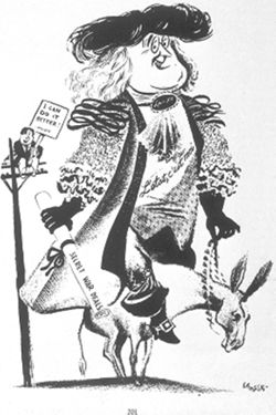
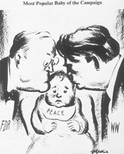
- Date Created:
- 1940
- Abstract:
- "L'Etat, C'est Moi," reprinted from The American Presidency in Political Cartoons: 1776-1976, p. 201.
- Call Number:
- 39B-1067107
- Alternate Identifier:
- 1067107
- Persistent URL:
- http://purl.dlib.indiana.edu/iudl/images/VAD5457/VAD5457-1067107
-

- Date Created:
- 1940
- Call Number:
- 39C-1067108
- Alternate Identifier:
- 1067108
- Persistent URL:
- http://purl.dlib.indiana.edu/iudl/images/VAD5457/VAD5457-1067108
-

- Date Created:
- 1940
- Call Number:
- 39D-1067109
- Alternate Identifier:
- 1067109
- Persistent URL:
- http://purl.dlib.indiana.edu/iudl/images/VAD5457/VAD5457-1067109
-
![Floyd County [Indiana] land use map : preliminary](https://iiif.uits.iu.edu/iiif/2/r207vr80n%2Ffiles%2Fba1ce671-118c-499c-8c40-0c3612b65e19/full/250,/0/default.jpg)
- Subject:
- Geographic Subject: Floyd County (Ind.) and Topical Subject: Land use
- Creator:
- Floyd County (Ind.). Land Use Planning Committee
- Publisher:
- Floyd County (Ind.). Land Use Planning Committee
- Date Created:
- 1940
- Identifier:
- VAC3073-M-00110
- Genre:
- Thematic maps
- Geographic Location:
- Coordinates: W0860159 W0854537 N0382508 N0381047
- Related URL:
- Catalog URL: https://iucat.iu.edu/catalog/5126281
- Abstract:
- Includes chart showing type of land use, acreage, and recommended use.
- Call Number:
- G4093.F5G4 1940 .F56
- Caption:
- Imprint: [New Albany, Ind.?] : The Committee, [1940?]
- Physical Description:
- Scale: Scale not given. and Dimensions: 18 x 17 cm, on sheet 39 x 28 cm
- Alternate Identifier:
- Title Control Number: a5126281
- Persistent URL:
- https://purl.dlib.indiana.edu/iudl/images/VAC3073/VAC3073-M-00110
-
![Crawford County [Indiana] land use map: preliminary](https://iiif.uits.iu.edu/iiif/2/4x51jm535%2Ffiles%2Fa4e48692-d643-428b-b306-48b4149d9cca/full/250,/0/default.jpg)
- Subject:
- Topical Subject: Land use and Geographic Subject: Crawford County (Ind.)
- Creator:
- Crawford County (Ind.). Land Use Planning Committee
- Publisher:
- Crawford County (Ind.). Land Use Planning Committee
- Date Created:
- 1940
- Identifier:
- VAC3073-M-00755
- Genre:
- Thematic maps
- Geographic Location:
- Coordinates: W0864053 W0861443 N0382522 N0380619
- Related URL:
- Catalog URL: https://iucat.iu.edu/catalog/5125845
- Abstract:
- Includes chart showing type of land use, acreage, and recommended use.
- Call Number:
- G4093.C7G4 1940 .C73
- Caption:
- Imprint: [English, Ind,?] : The Committee, [1940?]
- Physical Description:
- Dimensions: 24 x 25 cm, on sheet 28 x 39 cm and Scale: Scale not given.
- Alternate Identifier:
- Title Control Number: a5125845
- Persistent URL:
- https://purl.dlib.indiana.edu/iudl/images/VAC3073/VAC3073-M-00755
-
![Warrick County [Indiana] land use map : preliminary](https://iiif.uits.iu.edu/iiif/2/1z40mw11c%2Ffiles%2Fdf0b1772-63ad-4eb7-a01c-aa6b48eaa924/full/250,/0/default.jpg)
- Subject:
- Geographic Subject: Warrick County (Ind.) and Topical Subject: Land use
- Creator:
- Warrick County (Ind.). Land Use Planning Committee
- Publisher:
- Warrick County (Ind.). Land Use Planning Committee
- Date Created:
- 1940
- Identifier:
- VAC3073-M-00180
- Genre:
- Thematic maps
- Geographic Location:
- Coordinates: W0872823 W0870102 N0381446 N0375244
- Related URL:
- Catalog URL: https://iucat.iu.edu/catalog/5126643
- Abstract:
- Includes chart showing type of land use, acreage, and recommended use.
- Call Number:
- G4093.W4 G4 1940 .W37
- Caption:
- Imprint: [Boonville, Ind.?] : The Committee, [1940?]
- Physical Description:
- Dimensions: 24 x 23 cm, on sheet 39 x 28 cm and Scale: Scale not given.
- Alternate Identifier:
- Title Control Number: a5126643
- Persistent URL:
- https://purl.dlib.indiana.edu/iudl/images/VAC3073/VAC3073-M-00180
-
![Owen County [Indiana] land use map : preliminary](https://iiif.uits.iu.edu/iiif/2/vm40zt743%2Ffiles%2F4526b850-2c0a-4c70-b6d8-a4d29088e57e/full/250,/0/default.jpg)
- Subject:
- Topical Subject: Land use and Geographic Subject: Owen County (Ind.)
- Creator:
- Owen County (Ind.). Land Use Planning Committee
- Publisher:
- Owen County (Ind.). Land Use Planning Committee
- Date Created:
- 1940
- Identifier:
- VAC3073-M-00753
- Genre:
- Thematic maps
- Geographic Location:
- Coordinates: W0870317 W0863750 N0392824 N0390956
- Related URL:
- Catalog URL: https://iucat.iu.edu/catalog/5126500
- Abstract:
- Includes chart showing type of land use, acreage, and recommended use.
- Call Number:
- G4093.O8G4 1940 O94
- Caption:
- Imprint: [Spencer, Ind.?] : The Committee, [1940?]
- Physical Description:
- Dimensions: 22 x 24 cm, on sheet 39 x 28 cm and Scale: Scale not given.
- Alternate Identifier:
- Title Control Number: a5126500
- Persistent URL:
- https://purl.dlib.indiana.edu/iudl/images/VAC3073/VAC3073-M-00753
-
![Indiana Porter quadrangle [1940 printing]](https://iiif.uits.iu.edu/iiif/2/qb98nk032%2Ffiles%2F56b05fe7-af3d-4253-a42a-a53971fe7601/full/250,/0/default.jpg)
- Subject:
- Geographic Subject: Porter County (Ind.) and Geographic Subject: Lake County (Ind.)
- Creator:
- Clement, S. E. (Stephen Earl), 1894-1981 and Geological Survey (U.S.)
- Publisher:
- Geological Survey (U.S.)
- Date Created:
- 1940
- Identifier:
- VAC3073-M-01299
- Genre:
- 15 minute topographic maps, Quadrangle maps, and Topographic maps
- Geographic Location:
- Coordinates: W0871500 W0870000 N0414500 N0413000
- Related URL:
- Catalog URL: https://iucat.iu.edu/catalog/18416370
- Abstract:
- Filing title: Porter, Ind. Edition of 1940. Polyconic projection. Relief shown by contours and spot heights. Contour interval 10 feet. Surveyed in 1934. Repr...
- Call Number:
- G4090 s62 .G4 Porter 1940
- Caption:
- Imprint: Washington, D.C. : U.S. Dept. of the Interior, Geological Survey, 1940
- Physical Description:
- Scale: 1:62,500 and Dimensions: 45 x 42 cm or smaller
- Alternate Identifier:
- Title Control Number: a18416370
- Persistent URL:
- https://purl.dlib.indiana.edu/iudl/images/VAC3073/VAC3073-M-01299
- Provenance:
- Part of Geological Survey (U.S.). Indiana 1:62,500.
-
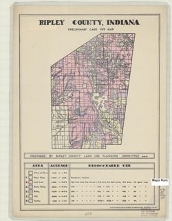
- Subject:
- Geographic Subject: Ripley County (Ind.) and Topical Subject: Land use
- Creator:
- Ripley County (Ind.). Land Use Planning Committee
- Publisher:
- United States. Bureau of Agricultural Economics
- Date Created:
- 1940
- Identifier:
- VAC3073-M-00030
- Genre:
- Thematic maps
- Geographic Location:
- Coordinates: W0852641 W0850354 N0391837 N0385446
- Related URL:
- Catalog URL: https://iucat.iu.edu/catalog/5126533
- Abstract:
- "Color reproduction by Bureau of Agricultural Economics, U.S.D.A." "8-21-40" Includes chart showing type of land use, acreage, and recomm...
- Call Number:
- G4093.R5 G4 1940 .R57
- Caption:
- Imprint: [Washington, D.C.?] : U.S. Bureau of Agricultural Economics, [1940]
- Physical Description:
- Dimensions: 21 x 16 cm, on sheet 38 x 28 cm and Scale: Scale not given.
- Alternate Identifier:
- Title Control Number: a5126533
- Persistent URL:
- https://purl.dlib.indiana.edu/iudl/images/VAC3073/VAC3073-M-00030
-
![Ohio County [Indiana] preliminary land use map](https://iiif.uits.iu.edu/iiif/2/r494wn92n%2Ffiles%2F1c94efdb-0aa0-4604-ab15-ea52383eb128/full/250,/0/default.jpg)
- Subject:
- Topical Subject: Land use and Geographic Subject: Ohio County (Ind.)
- Creator:
- Ohio County (Ind.). Land Use Planning Committtee
- Publisher:
- Ohio County (Ind.). Land Use Planning Committtee
- Date Created:
- 1940
- Identifier:
- VAC3073-M-00155
- Genre:
- Thematic maps
- Geographic Location:
- Coordinates: W0850825 W0844947 N0390151 N0385403
- Related URL:
- Catalog URL: https://iucat.iu.edu/catalog/5126485
- Abstract:
- Includes chart showing type of land use, acreage, and recommended use.
- Call Number:
- G4093.O3 1940 .O45
- Caption:
- Imprint: [Rising Sun, Ind.?] : The Committee, [1940?]
- Physical Description:
- Dimensions: 11 x 19 cm, on sheet 39 x 28 cm and Scale: Scale not given.
- Alternate Identifier:
- Title Control Number: a5126485
- Persistent URL:
- https://purl.dlib.indiana.edu/iudl/images/VAC3073/VAC3073-M-00155
-
![Indiana Porter quadrangle [1940 printing]](https://iiif.uits.iu.edu/iiif/2/000013119%2Ffiles%2F0b2153bf-bc62-414d-8775-578073b39f68/full/250,/0/default.jpg)
- Subject:
- Geographic Subject: Lake County (Ind.) and Geographic Subject: Porter County (Ind.)
- Creator:
- Geological Survey (U.S.) and Clement, S. E. (Stephen Earl), 1894-1981
- Publisher:
- Geological Survey (U.S.)
- Date Created:
- 1940
- Identifier:
- VAC3073-M-01379
- Genre:
- Topographic maps, Quadrangle maps, and 15 minute topographic maps
- Geographic Location:
- Coordinates: W0871500 W0870000 N0414500 N0413000
- Related URL:
- Catalog URL: https://iucat.iu.edu/catalog/18416370
- Abstract:
- Filing title: Porter, Ind. Edition of 1940. Polyconic projection. Relief shown by contours and spot heights. Contour interval 10 feet. Surveyed in 1934. Repr...
- Call Number:
- G4090 s62 .G4 Porter 1940
- Caption:
- Imprint: Washington, D.C. : U.S. Dept. of the Interior, Geological Survey, 1940
- Physical Description:
- Scale: 1:62,500 and Dimensions: 45 x 42 cm or smaller
- Alternate Identifier:
- Title Control Number: a18416370
- Persistent URL:
- https://purl.dlib.indiana.edu/iudl/images/VAC3073/VAC3073-M-01379
- Provenance:
- Part of Geological Survey (U.S.). Indiana 1:62,500.
-
![Washington County [Indiana] land use map : preliminary](https://iiif.uits.iu.edu/iiif/2/vq280q904%2Ffiles%2F783115ab-1c66-4d7e-b7d2-60280c29643b/full/250,/0/default.jpg)
- Subject:
- Topical Subject: Land use and Geographic Subject: Washington County (Ind.)
- Creator:
- Washington County (Ind.). Land Use Planning Committee
- Publisher:
- Washington County (Ind.). Land Use Planning Committee
- Date Created:
- 1940
- Identifier:
- VAC3073-M-00034
- Genre:
- Maps
- Geographic Location:
- Coordinates: W0861836 W0855051 N0384700 N0382504
- Related URL:
- Catalog URL: https://iucat.iu.edu/catalog/5126654
- Abstract:
- Includes chart showing type of land use, acreage, and recommended use.
- Call Number:
- G4093.W5 G4 1940 .W37
- Caption:
- Imprint: [Salem, Ind.?] : The Committee, [1940?]
- Physical Description:
- Dimensions: 23 x 23 cm, on sheet 39 x 28 cm and Scale: Scale not given.
- Alternate Identifier:
- Title Control Number: a5126654
- Persistent URL:
- https://purl.dlib.indiana.edu/iudl/images/VAC3073/VAC3073-M-00034
-
![Putnam County [Indiana] land use map : preliminary](https://iiif.uits.iu.edu/iiif/2/ff3669524%2Ffiles%2Fa99c639f-fb69-43c3-a158-8bffb65d6978/full/250,/0/default.jpg)
- Subject:
- Topical Subject: Land use and Geographic Subject: Putnam County (Ind.)
- Creator:
- Putnam County (Ind.). Land Use Planning Committee
- Publisher:
- Putnam County (Ind.). Land Use Planning Committee
- Date Created:
- 1940
- Identifier:
- VAC3073-M-00324
- Genre:
- Thematic maps
- Geographic Location:
- Coordinates: W0870053 W0863829 N0395200 N0392812
- Related URL:
- Catalog URL: https://iucat.iu.edu/catalog/5126528
- Abstract:
- Includes chart showing type of land use, acreage, and recommended use.
- Call Number:
- G4093.P8G4 1940 .P88
- Caption:
- Imprint: [Greencastle, Ind.?] : The Committee, [1940?]
- Physical Description:
- Dimensions: 23 x 17 cm, on sheet 39 x 28 cm and Scale: Scale not given.
- Alternate Identifier:
- Title Control Number: a5126528
- Persistent URL:
- https://purl.dlib.indiana.edu/iudl/images/VAC3073/VAC3073-M-00324
-
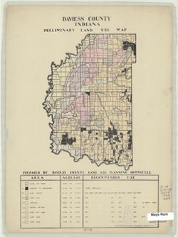
- Subject:
- Geographic Subject: Daviess County (Ind.) and Topical Subject: Land use
- Creator:
- Daviess County (Ind.). Land Use Planning Committee
- Publisher:
- United States. Bureau of Agricultural Economics
- Date Created:
- 1940
- Identifier:
- VAC3073-M-00818
- Genre:
- Thematic maps
- Geographic Location:
- Coordinates: W0871645 W0865414 N0385415 N0382925
- Related URL:
- Catalog URL: https://iucat.iu.edu/catalog/5125899
- Abstract:
- "Color reproduction by Bureau of Agricultural Economics, U.S.D.A." Includes chart showing type of land use, acreage, and recommended use.
- Call Number:
- G4093 .D2G4 1940 .D38
- Caption:
- Imprint: [Washington, D.C.?] : U.S. Bureau of Agricultural Economics, [1940]
- Physical Description:
- Scale: Scale not given. and Dimensions: 23 x 16 cm, on sheet 38 x 28 cm
- Alternate Identifier:
- Title Control Number: a5125899
- Persistent URL:
- https://purl.dlib.indiana.edu/iudl/images/VAC3073/VAC3073-M-00818
-
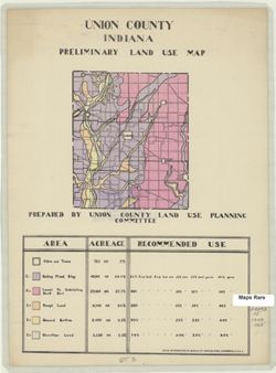
- Subject:
- Geographic Subject: Union County (Ind.) and Topical Subject: Land use
- Creator:
- Union County (Ind.). Land Use Planning Committee
- Publisher:
- United States. Bureau of Agricultural Economics
- Date Created:
- 1940
- Identifier:
- VAC3073-M-00409
- Genre:
- Thematic maps
- Geographic Location:
- Coordinates: W0850210 W0844851 N0394345 N0393119
- Related URL:
- Catalog URL: https://iucat.iu.edu/catalog/5126621
- Abstract:
- "Color reproduction by Bureau of Agricultural Economics, U.S.D.A." Includes chart showing type of land use, acreage, and recommended use.
- Call Number:
- G4093.U5 1940 .U55
- Caption:
- Imprint: [Washington, D.C.?] : U.S. Bureau of Agricultural Economics, [1940?]
- Physical Description:
- Scale: Scale not given. and Dimensions: 15 x 13 cm, on sheet 38 x 28 cm
- Alternate Identifier:
- Title Control Number: a5126621
- Persistent URL:
- https://purl.dlib.indiana.edu/iudl/images/VAC3073/VAC3073-M-00409
-
![Switzerland County [Indiana] preliminary land use map](https://iiif.uits.iu.edu/iiif/2/7p88dk86q%2Ffiles%2F702dbc2b-a33d-45c2-9347-ad26de2efd2e/full/250,/0/default.jpg)
- Subject:
- Geographic Subject: Switzerland County (Ind.) and Topical Subject: Land use
- Creator:
- Switzerland County (Ind.). Land Use Planning Committee
- Publisher:
- Switzerland County (Ind.). Land Use Planning Committee
- Date Created:
- 1940
- Identifier:
- VAC3073-M-00661
- Genre:
- Thematic maps
- Geographic Location:
- Coordinates: W0851212 W0844704 N0385546 N0384114
- Related URL:
- Catalog URL: https://iucat.iu.edu/catalog/5126605
- Abstract:
- Includes chart showing type of land use, acreage, and recommended use.
- Call Number:
- G4093.S9 1940 .S95
- Caption:
- Imprint: [Vevay, Ind.?] : The Committee, [1940?]
- Physical Description:
- Dimensions: 21 x 16 cm, on sheet 39 x 28 cm and Scale: Scale not given.
- Alternate Identifier:
- Title Control Number: a5126605
- Persistent URL:
- https://purl.dlib.indiana.edu/iudl/images/VAC3073/VAC3073-M-00661
-
![Jefferson County [Indiana] preliminary land use map](https://iiif.uits.iu.edu/iiif/2/2f75sc94w%2Ffiles%2F7a98897d-f193-46e6-9bdf-a873b1f3fc06/full/250,/0/default.jpg)
- Subject:
- Geographic Subject: Jefferson County (Ind.) and Topical Subject: Land use
- Creator:
- Jefferson County (Ind.). Land Use Planning Committee
- Publisher:
- United States. Bureau of Agricultural Economics
- Date Created:
- 1940
- Identifier:
- VAC3073-M-00300
- Genre:
- Thematic maps
- Geographic Location:
- Coordinates: W0854102 W0851205 N0385450 N0383509
- Related URL:
- Catalog URL: https://iucat.iu.edu/catalog/5126351
- Abstract:
- "Color reproduction by Bureau of Agricultural Economics, U.S.D.A." Includes chart showing type of land use, acreage, and recommended use.
- Call Number:
- G4093.J5 G4 1940 .J44
- Caption:
- Imprint: [Washington, D.C.?] : U.S. Bureau of Agricultural Economics, [1940?]
- Physical Description:
- Dimensions: 19 x 22 cm, on sheet 38 x 28 cm and Scale: Scale not given.
- Alternate Identifier:
- Title Control Number: a5126351
- Persistent URL:
- https://purl.dlib.indiana.edu/iudl/images/VAC3073/VAC3073-M-00300
-
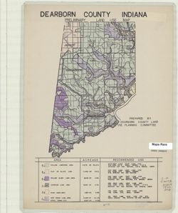
- Subject:
- Geographic Subject: Dearborn County (Ind.) and Topical Subject: Land use
- Creator:
- Dearborn County (Ind.). Land Use Planning Committee
- Publisher:
- Dearborn County (Ind.). Land Use Planning Committee
- Date Created:
- 1940
- Identifier:
- VAC3073-M-00613
- Genre:
- Thematic maps
- Geographic Location:
- Coordinates: W0850757 W0844909 N0391826 N0385607
- Related URL:
- Catalog URL: https://iucat.iu.edu/catalog/5126249
- Abstract:
- Includes chart showing type of land use, acreage, and recommended use.
- Call Number:
- G4093.D3G4 1940 .D43
- Caption:
- Imprint: [Lawrenceburg, Ind.?] : The Committee, [1940?]
- Physical Description:
- Dimensions: 26 x 17 cm, on sheet 39 x 28 cm and Scale: Scale not given.
- Alternate Identifier:
- Title Control Number: a5126249
- Persistent URL:
- https://purl.dlib.indiana.edu/iudl/images/VAC3073/VAC3073-M-00613
-
![Vigo County [Indiana] land use map: preliminary](https://iiif.uits.iu.edu/iiif/2/gq67kv03f%2Ffiles%2Fbc5313f9-e338-4b17-a48d-60e4496abc8a/full/250,/0/default.jpg)
- Subject:
- Geographic Subject: Vigo County (Ind.) and Topical Subject: Land use
- Creator:
- Vigo County (Ind.). Land Use Planning Committee
- Publisher:
- Vigo County (Ind.). Land Use Planning Committee
- Date Created:
- 1940
- Identifier:
- VAC3073-M-00953
- Genre:
- Thematic maps
- Geographic Location:
- Coordinates: W0873716 W0871156 N0393629 N0391532
- Related URL:
- Catalog URL: https://iucat.iu.edu/catalog/5126635
- Abstract:
- Includes chart showing type of land use, acreage, and recommended use.
- Call Number:
- G4093.V5G4 1940 .V54
- Caption:
- Imprint: [Terre Haute, Ind.?] : The Committee, [1940?]
- Physical Description:
- Dimensions: 24 x 21 cm, on sheet 39 x 28 cm and Scale: Scale not given.
- Alternate Identifier:
- Title Control Number: a5126635
- Persistent URL:
- https://purl.dlib.indiana.edu/iudl/images/VAC3073/VAC3073-M-00953
-
![Posey County [Indiana] land use map : preliminary](https://iiif.uits.iu.edu/iiif/2/z603s182f%2Ffiles%2F435d231e-86e7-4295-89a3-c11ee3702fdf/full/250,/0/default.jpg)
- Subject:
- Topical Subject: Land use and Geographic Subject: Posey County (Ind.)
- Creator:
- Posey County (Ind.). Land Use Planning Committee
- Publisher:
- Posey County (Ind.). Land Use Planning Committee
- Date Created:
- 1940
- Identifier:
- VAC3073-M-00997
- Genre:
- Thematic maps
- Geographic Location:
- Coordinates: W0880552 W0874117 N0381349 N0374618
- Related URL:
- Catalog URL: https://iucat.iu.edu/catalog/5126520
- Abstract:
- Includes chart showing type of land use, acreage, and recommended use.
- Call Number:
- G4093.P6G4 1940 .P67
- Caption:
- Imprint: [Mount Vernon, Ind.?] : The Committee, [1940?]
- Physical Description:
- Scale: Scale not given. and Dimensions: 28 x 19 cm, on sheet 39 x 28 cm
- Alternate Identifier:
- Title Control Number: a5126520
- Persistent URL:
- https://purl.dlib.indiana.edu/iudl/images/VAC3073/VAC3073-M-00997
-
![Clark County [Indiana] land use map](https://iiif.uits.iu.edu/iiif/2/0p097b31w%2Ffiles%2F05b32dea-49f5-4006-84cd-ba5a5f21b5fb/full/250,/0/default.jpg)
- Subject:
- Geographic Subject: Clark County (Ind.) and Topical Subject: Land use
- Creator:
- Clark County (Ind.). Land Use Planning Committee
- Publisher:
- Clark County (Ind.). Land Use Planning Committee
- Date Created:
- 1940
- Identifier:
- VAC3073-M-00765
- Genre:
- Thematic maps
- Geographic Location:
- Coordinates: W0855940 W0852455 N0383624 N0381601
- Related URL:
- Catalog URL: https://iucat.iu.edu/catalog/5125787
- Abstract:
- Includes chart showing type of land use, acreage, and recommended use.
- Call Number:
- G4093.C4G4 1940 C53
- Caption:
- Imprint: [Jeffersonville, Ind.?] : The Committee, [1940?]
- Physical Description:
- Scale: Scale not given. and Dimensions: 26 x 19 cm, on sheet 39 x 28 cm
- Alternate Identifier:
- Title Control Number: a5125787
- Persistent URL:
- https://purl.dlib.indiana.edu/iudl/images/VAC3073/VAC3073-M-00765
-
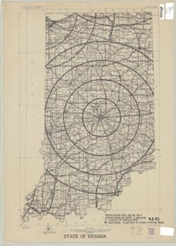
- Subject:
- Topical Subject: National cemeteries and Geographic Subject: Indiana
- Publisher:
- [U.S. War Dept.?]
- Date Created:
- 1940
- Identifier:
- VAC3073-M-00333
- Genre:
- Thematic maps
- Geographic Location:
- Coordinates: W0880700 W0844500 N0414500 N0375200
- Related URL:
- Catalog URL: https://iucat.iu.edu/catalog/5177103
- Abstract:
- Shows proposed National Cemetery in Indianapolis with 25 mile concentric rings showing distance from the proposed National Cemetery and other National Cemete...
- Call Number:
- G4091.G54 1940 .S73
- Caption:
- Imprint: [Washington, D.C.? : U.S. War Dept.?, 194-?]
- Physical Description:
- Dimensions: 64 x 42 cm and Scale: 1:715,000
- Alternate Identifier:
- Title Control Number: a5177103
- Persistent URL:
- https://purl.dlib.indiana.edu/iudl/images/VAC3073/VAC3073-M-00333
-
![Pike County [Indiana] land use map : preliminary](https://iiif.uits.iu.edu/iiif/2/rx914s61v%2Ffiles%2Fceecabf2-e7fb-4138-930c-04b192729886/full/250,/0/default.jpg)
- Subject:
- Topical Subject: Land use and Geographic Subject: Pike County (Ind.)
- Creator:
- Pike County (Ind.). Land Use Planning Committee
- Publisher:
- Pike County (Ind.). Land Use Planning Committee
- Date Created:
- 1940
- Identifier:
- VAC3073-M-00686
- Genre:
- Thematic maps
- Geographic Location:
- Coordinates: W0872746 W0870419 N0383308 N0381351
- Related URL:
- Catalog URL: https://iucat.iu.edu/catalog/5126511
- Abstract:
- Includes chart showing type of land use, acreage, and recommended use.
- Call Number:
- G4093.P4G4 1940 .P55
- Caption:
- Imprint: [Petersburg, Ind.?] : The Committee, [1940?]
- Physical Description:
- Scale: Scale not given. and Dimensions: 24 x 23 cm, on sheet 39 x 28 cm
- Alternate Identifier:
- Title Control Number: a5126511
- Persistent URL:
- https://purl.dlib.indiana.edu/iudl/images/VAC3073/VAC3073-M-00686
-
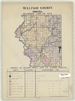
- Subject:
- Topical Subject: Land use and Geographic Subject: Sullivan County (Ind.)
- Creator:
- Sullivan County (Ind.). Land Use Planning Committee
- Publisher:
- United States. Bureau of Agricultural Economics
- Date Created:
- 1940
- Identifier:
- VAC3073-M-00727
- Genre:
- Thematic maps
- Geographic Location:
- Coordinates: W0873931 W0871425 N0391534 N0385405
- Related URL:
- Catalog URL: https://iucat.iu.edu/catalog/5126550
- Abstract:
- "Color reproduction by Bureau of Agricultural Economics, U.S.D.A." Includes chart showing type of land use, acreage, and recommended use.
- Call Number:
- G4093.S8G4 1940 .S85
- Caption:
- Imprint: [Washington, D.C.?] : U.S. Bureau of Agricultural Economics, [1940?]
- Physical Description:
- Dimensions: 21 x 19 cm, on sheet 38 x 28 cm and Scale: Scale not given.
- Alternate Identifier:
- Title Control Number: a5126550
- Persistent URL:
- https://purl.dlib.indiana.edu/iudl/images/VAC3073/VAC3073-M-00727
-
![Dubois County [Indiana] land use map : preliminary](https://iiif.uits.iu.edu/iiif/2/n583zx450%2Ffiles%2F8319c249-85b5-442f-8ac2-cef230e85e51/full/250,/0/default.jpg)
- Subject:
- Topical Subject: Land use and Geographic Subject: Dubois County (Ind.)
- Creator:
- Dubois County (Ind.). Land Use Planning Committee
- Publisher:
- Dubois County (Ind.). Land Use Planning Committee
- Date Created:
- 1940
- Identifier:
- VAC3073-M-00356
- Genre:
- Thematic maps
- Geographic Location:
- Coordinates: W0870423 W0864044 N0383135 N0381210
- Related URL:
- Catalog URL: https://iucat.iu.edu/catalog/5126254
- Abstract:
- Includes chart showing type of land use, acreage, and recommended use.
- Call Number:
- G4093.D8G4 1940 D83
- Caption:
- Imprint: [Jasper, Ind.?] : The Committee, [1940?]
- Physical Description:
- Dimensions: 22 x 22 cm, on sheet 39 x 28 cm and Scale: Scale not given.
- Alternate Identifier:
- Title Control Number: a5126254
- Persistent URL:
- https://purl.dlib.indiana.edu/iudl/images/VAC3073/VAC3073-M-00356
-
![Orange County [Indiana] preliminary land use map](https://iiif.uits.iu.edu/iiif/2/9p291f25v%2Ffiles%2Ffa8d35ba-54cc-4d4f-bc44-58833d93e051/full/250,/0/default.jpg)
- Subject:
- Topical Subject: Land use and Geographic Subject: Orange County (Ind.)
- Creator:
- Orange County (Ind.). Land Use Planning Committee
- Publisher:
- Orange County (Ind.). Land Use Planning Committee
- Date Created:
- 1940
- Identifier:
- VAC3073-M-00281
- Genre:
- Thematic maps
- Geographic Location:
- Coordinates: W0864059 W0861827 N0384119 N0382338
- Related URL:
- Catalog URL: https://iucat.iu.edu/catalog/5126491
- Abstract:
- Includes chart showing type of land use, acreage, and recommended use.
- Call Number:
- G4093.O6G4 1940 .O73
- Caption:
- Imprint: [Paoli, Ind.?] : The Committee, [1940?]
- Physical Description:
- Dimensions: 21 x 21 cm, on sheet 39 x 28 cm and Scale: Scale not given.
- Alternate Identifier:
- Title Control Number: a5126491
- Persistent URL:
- https://purl.dlib.indiana.edu/iudl/images/VAC3073/VAC3073-M-00281
-
![Spencer County [Indiana] land use map : preliminary](https://iiif.uits.iu.edu/iiif/2/1c18fj180%2Ffiles%2F9c0b4a8c-6bc8-420c-af21-908a4b5f3ba4/full/250,/0/default.jpg)
- Subject:
- Topical Subject: Land use and Geographic Subject: Spencer County (Ind.)
- Creator:
- Spencer County (Ind.). Land Use Planning Committee
- Publisher:
- Spencer County (Ind.). Land Use Planning Committee
- Date Created:
- 1940
- Identifier:
- VAC3073-M-00041
- Genre:
- Thematic maps
- Geographic Location:
- Coordinates: W0871606 W0864553 N0381218 N0374656
- Related URL:
- Catalog URL: https://iucat.iu.edu/catalog/5126542
- Abstract:
- Includes chart showing type of land use, acreage, and recommended use.
- Call Number:
- G4093.S5 G4 1940 .S64
- Caption:
- Imprint: [Rockport, Ind.?] : The Committee, [1940?]
- Physical Description:
- Dimensions: 27 x 25 cm, on sheet 39 x 28 cm and Scale: Scale not given.
- Alternate Identifier:
- Title Control Number: a5126542
- Persistent URL:
- https://purl.dlib.indiana.edu/iudl/images/VAC3073/VAC3073-M-00041
-
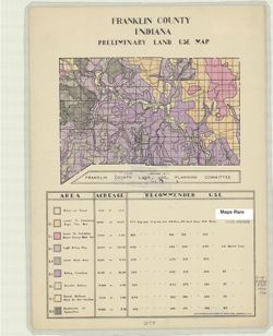
- Subject:
- Topical Subject: Land use and Geographic Subject: Franklin County (Ind.)
- Creator:
- Franklin County (Ind.). Land Use Planning Committee
- Publisher:
- United States. Bureau of Agricultural Economics
- Date Created:
- 1940
- Identifier:
- VAC3073-M-00144
- Genre:
- Thematic maps
- Geographic Location:
- Coordinates: W0851755 W0844855 N0393136 N0391605
- Related URL:
- Catalog URL: https://iucat.iu.edu/catalog/5126284
- Abstract:
- "Color reproduction by Bureau of Agricultural Economics, U.S.D.A." Includes chart showing type of land use, acreage, and recommended use.
- Call Number:
- G4093.F7G4 1940 .F73
- Caption:
- Imprint: [Washington, D.C.?] : U.S. Bureau of Agricultural Economics, [1940?]
- Physical Description:
- Dimensions: 15 x 21 cm, on sheet 38 x 28 cm and Scale: Scale not given.
- Alternate Identifier:
- Title Control Number: a5126284
- Persistent URL:
- https://purl.dlib.indiana.edu/iudl/images/VAC3073/VAC3073-M-00144
-
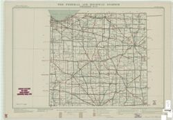
- Subject:
- Geographic Subject: Indiana and Topical Subject: Roads
- Creator:
- United States. Public Roads Administration
- Publisher:
- United States. Public Roads Administration
- Date Created:
- 1940
- Identifier:
- VAC3073-M-00588
- Genre:
- Road maps
- Geographic Location:
- Coordinates: W0880700 W0844500 N0414500 N0375200
- Related URL:
- Catalog URL: https://iucat.iu.edu/catalog/5164306
- Abstract:
- "Base map from U.S. Geological Survey state map." "Data corrected to May 1, 1940."
- Call Number:
- G4091.P2 1940 .U5
- Caption:
- Imprint: [Washington, D.C.?] : The Administration, [1940]
- Physical Description:
- Scale: 1:500,000 and Dimensions: 92 x 70 cm, sheets 55 x 79 cm
- Alternate Identifier:
- Title Control Number: a5164306
- Persistent URL:
- https://purl.dlib.indiana.edu/iudl/images/VAC3073/VAC3073-M-00588
-
![Fayette County [Indiana] preliminary land use map](https://iiif.uits.iu.edu/iiif/2/xk81kq192%2Ffiles%2F166701bf-144d-4037-bd2c-0e915f8f7b76/full/250,/0/default.jpg)
- Subject:
- Geographic Subject: Fayette County (Ind.) and Topical Subject: Land use
- Creator:
- Fayette County (Ind.). Land Use Planning Committee
- Publisher:
- Fayette County (Ind.). Land Use Planning Committee
- Date Created:
- 1940
- Identifier:
- VAC3073-M-00246
- Genre:
- Thematic maps
- Geographic Location:
- Coordinates: W0851805 W0850204 N0394718 N0393131
- Related URL:
- Catalog URL: https://iucat.iu.edu/catalog/5126278
- Abstract:
- Includes chart showing type of land use, acreage, and recommended use.
- Call Number:
- G4093.F3G4 1940 .F39
- Caption:
- Imprint: [Connersville, Ind.?] : The Committee, [1940?]
- Physical Description:
- Dimensions: 19 x 16 cm, on sheet 39 x 28 cm and Scale: Scale not given.
- Alternate Identifier:
- Title Control Number: a5126278
- Persistent URL:
- https://purl.dlib.indiana.edu/iudl/images/VAC3073/VAC3073-M-00246
-
![Vanderburgh County [Indiana] preliminary land use map](https://iiif.uits.iu.edu/iiif/2/qf85pf475%2Ffiles%2F018f45ab-c6b4-40b1-9e75-dc08e8ae02ae/full/250,/0/default.jpg)
- Subject:
- Geographic Subject: Vanderburgh County (Ind.) and Topical Subject: Land use
- Creator:
- Vanderburgh County (Ind.). Land Use Planning Committee
- Publisher:
- Vanderburgh County (Ind.). Land Use Planning Committee
- Date Created:
- 1940
- Identifier:
- VAC3073-M-00328
- Genre:
- Thematic maps
- Geographic Location:
- Coordinates: W0874202 W0872657 N0381006 N0374932
- Related URL:
- Catalog URL: https://iucat.iu.edu/catalog/5126629
- Abstract:
- Includes chart showing type of land use, acreage, and recommended use.
- Call Number:
- G4093.V3G4 1940 .V36
- Caption:
- Imprint: [Evansville, Ind.?] : The Committee, [1940?]
- Physical Description:
- Scale: Scale not given. and Dimensions: 26 x 14 cm, on sheet 39 x 28 cm
- Alternate Identifier:
- Title Control Number: a5126629
- Persistent URL:
- https://purl.dlib.indiana.edu/iudl/images/VAC3073/VAC3073-M-00328
-
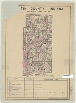
- Subject:
- Geographic Subject: Martin County (Ind.) and Topical Subject: Land use
- Creator:
- Martin County (Ind.). Land Use Planning Committee
- Publisher:
- United States. Bureau of Agricultural Economics
- Date Created:
- 1940
- Identifier:
- VAC3073-M-00782
- Genre:
- Thematic maps
- Geographic Location:
- Coordinates: W0865527 W0864056 N0385416 N0382941
- Related URL:
- Catalog URL: https://iucat.iu.edu/catalog/5126476
- Abstract:
- "Color reproduction by Bureau of Agricultural Economics, U.S.D.A." "8-31-40." Includes chart showing type of land use, acreage, and recom...
- Call Number:
- G4093.M5G4 1940 .M37
- Caption:
- Imprint: [Washington, D.C.?] : U.S. Bureau of Agricultural Economics, [1940]
- Physical Description:
- Scale: Scale not given. and Dimensions: 25 x 12 cm, on sheet 39 x 28 cm
- Alternate Identifier:
- Title Control Number: a5126476
- Persistent URL:
- https://purl.dlib.indiana.edu/iudl/images/VAC3073/VAC3073-M-00782
-
![Harrison County [Indiana] land use map : preliminary](https://iiif.uits.iu.edu/iiif/2/fb495d293%2Ffiles%2Fa6215f59-e4a8-4559-b192-18779587518f/full/250,/0/default.jpg)
- Subject:
- Topical Subject: Land use and Geographic Subject: Harrison County (Ind.)
- Creator:
- Harrison County (Ind.). Land Use Planning Committee
- Publisher:
- Harrison County (Ind.). Land Use Planning Committee
- Date Created:
- 1940
- Identifier:
- VAC3073-M-00901
- Genre:
- Thematic maps
- Geographic Location:
- Coordinates: W0861947 W0855402 N0382521 N0375728
- Related URL:
- Catalog URL: https://iucat.iu.edu/catalog/5126325
- Abstract:
- Includes chart showing type of land use, acreage, and recommended use.
- Call Number:
- G4093.H4G4 1940 .H37
- Caption:
- Imprint: [Corydon, Ind.?] : The Committee, [1940?]
- Physical Description:
- Scale: Scale not given. and Dimensions: 28 x 21 cm, on sheet 39 x 28 cm
- Alternate Identifier:
- Title Control Number: a5126325
- Persistent URL:
- https://purl.dlib.indiana.edu/iudl/images/VAC3073/VAC3073-M-00901
-

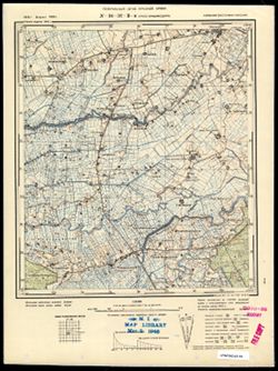
- Description:
- 1926
- Subject:
- Geographic Subject: Wieleń, Topical Subject: Soviet Union, and Topical Subject: Maps
- Publisher:
- Генеральный штаб Красной Армии
- Language:
- Russian
- Date Created:
- 1940
- Identifier:
- VAC9619-003881
- Genre:
- Topographic Maps and Military Maps
- Geographic Location:
- Coordinates: 52.667, 16, 53, 16.5
- Related URL:
- Catalog URL: https://iucat.iu.edu/catalog/5020129 and Download GeoTIFF: https://drive.google.com/file/d/1e0l5gZYZYukW5-SA95MhoYhbK0LMtX5h/view?usp=sharing
- Abstract:
- Modern area represented: Wieleń, Greater Poland, Poland
- Call Number:
- G7000 s100 .S7 sheet N-33-117
- City:
- Филене (Filehne)
- Copyright Holder:
- No Copyright - United States
- Country:
- Германия (Germany)
- Physical Description:
- Scale: 1:100,000
- Persistent URL:
- http://purl.dlib.indiana.edu/iudl/images/VAC9619/VAC9619-003881
- Provenance:
- DMA Topographic Center, Army Map Service Library, OMAHA, Library of Congress Geography & Map Division
-
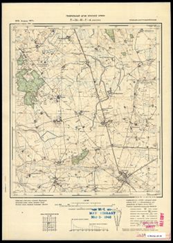
- Description:
- 1893
- Subject:
- Geographic Subject: Ostrowiec Świętokrzyski, Topical Subject: Soviet Union, and Topical Subject: Maps
- Publisher:
- Генеральный штаб Красной Армии
- Language:
- Russian
- Date Created:
- 1940
- Identifier:
- VAC9619-002824
- Genre:
- Topographic Maps and Military Maps
- Geographic Location:
- Coordinates: 50.667, 21, 51, 21.5
- Related URL:
- Download GeoTIFF: https://drive.google.com/file/d/1dCs56aJfHbIoqFvjV3G6y_azZfMDjo25/view?usp=sharing and Catalog URL: https://iucat.iu.edu/catalog/5020129
- Abstract:
- Modern area represented: Ostrowiec Świętokrzyski, Świętokrzyskie province, Poland
- Call Number:
- G7000 s100 .S7 sheet M-34-43
- City:
- Островец (Ostrowiec)
- Copyright Holder:
- No Copyright - United States
- State/Province:
- Область государственных интересов Германии (Region of German state interests)
- Physical Description:
- Scale: 1:100,000
- Persistent URL:
- http://purl.dlib.indiana.edu/iudl/images/VAC9619/VAC9619-002824
- Provenance:
- DMA Topographic Center, OMAHA
-
- Subject:
- Geographic Subject: Gastellovo, Topical Subject: Maps, and Topical Subject: Soviet Union
- Publisher:
- Генеральный штаб Красной Армии
- Language:
- Russian
- Date Created:
- 1940
- Identifier:
- VAC9619-003608
- Genre:
- Military Maps and Topographic Maps
- Geographic Location:
- Coordinates: 55, 21.5, 55.083, 21.625
- Related URL:
- Download GeoTIFF: https://drive.google.com/file/d/1MZqo3Hsc5RDE9S6gTO-v8LULaYz-h7eG/view?usp=sharing and Catalog URL: https://iucat.iu.edu/catalog/14701157
- Abstract:
- Modern area represented: Гастеллово (Gastellovo), Kaliningradskaya oblast, Russia
- Call Number:
- G7063.K2 s25 .S6 sheet N-34-32-C-c
- City:
- Гросс Фридрихсдорф (Gross-Friedrichsdorf)
- Copyright Holder:
- No Copyright - United States
- Country:
- Германия (Восточная Пруссия) (Germany (East Prussia))
- Physical Description:
- Scale: 1:25,000
- Persistent URL:
- http://purl.dlib.indiana.edu/iudl/images/VAC9619/VAC9619-003608
- Provenance:
- M. I. Map Library
-

- Subject:
- Geographic Subject: Pravdino, Topical Subject: Maps, and Topical Subject: Soviet Union
- Publisher:
- Генеральный штаб Красной Армии
- Language:
- Russian
- Date Created:
- 1940
- Identifier:
- VAC9619-003716
- Genre:
- Military Maps and Topographic Maps
- Geographic Location:
- Coordinates: 54.833, 22.5, 54.913, 22.625
- Related URL:
- Download GeoTIFF: https://drive.google.com/file/d/1Pj1DR5fQarxZS6xEnJBWhxqS5OgD1i5X/view?usp=sharing and Catalog URL: https://iucat.iu.edu/catalog/14701157
- Abstract:
- Modern area represented: Правдино (Pravdino), Kaliningradskaya oblast, Russia
- Call Number:
- G7063.K2 s25 .S6 sheet N-34-46-A-c
- City:
- Грумбковсфельде (Grumbkowsfelde)
- Copyright Holder:
- No Copyright - United States
- Country:
- Германия (Восточная Пруссия) (Germany (East Prussia))
- Physical Description:
- Scale: 1:25,000
- Persistent URL:
- http://purl.dlib.indiana.edu/iudl/images/VAC9619/VAC9619-003716
- Provenance:
- CIA Map Branch -- Received
-
- Subject:
- Topical Subject: Maps, Topical Subject: Soviet Union, and Geographic Subject: Vesnovo
- Publisher:
- Генеральный штаб Красной Армии
- Language:
- Russian
- Date Created:
- 1940
- Identifier:
- VAC9619-003711
- Genre:
- Military Maps and Topographic Maps
- Geographic Location:
- Coordinates: 54.75, 22.25, 54.833, 22.375
- Related URL:
- Catalog URL: https://iucat.iu.edu/catalog/14701157 and Download GeoTIFF: https://drive.google.com/file/d/10sCgRzFJLnu0eF0GiQnWqBfZ8ZsS4sKw/view?usp=sharing
- Abstract:
- Modern area represented: Весново (Vesnovo), Kaliningradskaya oblast, Russia
- Call Number:
- G7063.K2 s25 .S6 sheet N-34-45-D-а
- City:
- Куссен (Kussen)
- Copyright Holder:
- No Copyright - United States
- Country:
- Германия (Восточная Пруссия) (Germany (East Prussia))
- Physical Description:
- Scale: 1:25,000
- Persistent URL:
- http://purl.dlib.indiana.edu/iudl/images/VAC9619/VAC9619-003711
- Provenance:
- M. I. Map Library
-

- Subject:
- Topical Subject: Soviet Union, Topical Subject: Maps, and Geographic Subject: Novo-Biyskoye
- Publisher:
- Генеральный штаб РККА
- Language:
- Russian
- Date Created:
- 1940
- Identifier:
- VAC9619-003763
- Genre:
- Military Maps and Topographic Maps
- Geographic Location:
- Coordinates: 54.416667, 21.25, 54.5, 21.375
- Related URL:
- Download GeoTIFF: https://drive.google.com/file/d/12ADQ-KwvRsbz_NrkgrhOE6_uEKunq8Ac/view?usp=sharing and Catalog URL: https://iucat.iu.edu/catalog/14701157
- Abstract:
- Modern area represented: Ново-Бийское (Novo-Biyskoye), Kaliningradskaya oblast, Russia
- Call Number:
- G7063.K2 s25 .S6 sheet N-34-55-D-а
- Caption:
- Captured map
- City:
- Фридрихсвальде (Friedrichswalde)
- Copyright Holder:
- No Copyright - United States
- Country:
- Германия (Восточная Пруссия) (Germany (East Prussia))
- Physical Description:
- Scale: 1:25,000
- Persistent URL:
- http://purl.dlib.indiana.edu/iudl/images/VAC9619/VAC9619-003763
- Provenance:
- Army Map Service Library, OMAHA, Library of Congress Geography & Map Division
-
- Subject:
- Geographic Subject: Zaostrov’ye, Topical Subject: Soviet Union, and Topical Subject: Maps
- Publisher:
- Генеральный штаб РККА
- Language:
- Russian
- Date Created:
- 1940
- Identifier:
- VAC9619-003644
- Genre:
- Military Maps and Topographic Maps
- Geographic Location:
- Coordinates: 54.913, 20.25, 55, 20.375
- Related URL:
- Download GeoTIFF: https://drive.google.com/file/d/1_Rfi01p_uZbHxyLfwbvN0caeO3xUwMzh/view?usp=sharing and Catalog URL: https://iucat.iu.edu/catalog/14701157
- Abstract:
- Modern area represented: Заостровье (Zaostrov’ye), Kaliningradskaya oblast, Russia
- Call Number:
- G7063.K2 s25 .S6 sheet N-34-41-B-a
- City:
- Рантау (Rantau)
- Copyright Holder:
- No Copyright - United States
- Country:
- Германия (Восточная Пруссия) (Germany (East Prussia))
- Physical Description:
- Scale: 1:25,000
- Persistent URL:
- http://purl.dlib.indiana.edu/iudl/images/VAC9619/VAC9619-003644
- Provenance:
- CIA Map Branch -- Received
-
- Subject:
- Topical Subject: Soviet Union, Topical Subject: Maps, and Geographic Subject: Dorozhnyy
- Publisher:
- Генеральный штаб РККА
- Language:
- Russian
- Date Created:
- 1940
- Identifier:
- VAC9619-003653
- Genre:
- Military Maps and Topographic Maps
- Geographic Location:
- Coordinates: 54.75, 20.375, 54.833, 20.5
- Related URL:
- Download GeoTIFF: https://drive.google.com/file/d/1O9LWLzbW4TC8Jmx1-arl8hWMH0L5TBPK/view?usp=sharing and Catalog URL: https://iucat.iu.edu/catalog/14701157
- Abstract:
- Modern area represented: Дорожный (Dorozhnyy), Kaliningradskaya oblast, Russia
- Call Number:
- G7063.K2 s25 .S6 sheet N-34-41-D-b
- City:
- Нойхоф (Neuhof)
- Copyright Holder:
- No Copyright - United States
- Country:
- Германия (Восточная Пруссия) (Germany (East Prussia))
- Physical Description:
- Scale: 1:25,000
- Persistent URL:
- http://purl.dlib.indiana.edu/iudl/images/VAC9619/VAC9619-003653
- Provenance:
- CIA Map Branch -- Received
-
- Description:
- 1891
- Subject:
- Topical Subject: Soviet Union, Topical Subject: Maps, and Geographic Subject: Dragomireşti
- Publisher:
- Генеральный штаб Красной Армии
- Language:
- Russian
- Date Created:
- 1940
- Identifier:
- VAC9619-001755
- Genre:
- Military Maps and Topographic Maps
- Geographic Location:
- Coordinates: 46.3333, 27, 46.6667, 27.5
- Related URL:
- Download GeoTIFF: https://drive.google.com/file/d/1hCPO_hgwRlOoKYWPQdYYSitq_p-y_Ezx/view?usp=sharing and Catalog URL: https://iucat.iu.edu/catalog/5020129
- Abstract:
- Modern area represented: Dragomireşti, Vaslui county, Romania
- Call Number:
- G7000 s100 .S7 sheet L-35-55
- City:
- Драгомирешти (Dragomireşti)
- Copyright Holder:
- No Copyright - United States
- Country:
- Румыния (Romania)
- Physical Description:
- Scale: 1:100,000
- Persistent URL:
- http://purl.dlib.indiana.edu/iudl/images/VAC9619/VAC9619-001755
- Provenance:
- CIA Map Library
-

- Description:
- 1882
- Subject:
- Geographic Subject: Racibórz, Topical Subject: Soviet Union, and Topical Subject: Maps
- Publisher:
- Генеральный штаб Красной Армии
- Language:
- Russian
- Date Created:
- 1940
- Identifier:
- VAC9619-002860
- Genre:
- Military Maps and Topographic Maps
- Geographic Location:
- Coordinates: 50, 18, 50.333, 18.5
- Related URL:
- Download GeoTIFF: https://drive.google.com/file/d/1XcG44qM_SkibVzjFK8EuHetzDeu3O5g7/view?usp=sharing and Catalog URL: https://iucat.iu.edu/catalog/5020129
- Abstract:
- Modern area represented: Racibórz, Silesian province, Poland
- Call Number:
- G7000 s100 .S7 sheet M-34-61
- City:
- Ратибор (Ratibor)
- Copyright Holder:
- No Copyright - United States
- Country:
- Германия (Germany)
- Physical Description:
- Scale: 1:100,000
- Persistent URL:
- http://purl.dlib.indiana.edu/iudl/images/VAC9619/VAC9619-002860
- Provenance:
- DMA Topographic Center, Army Map Service Library, Library of Congress Geography & Map Division
-

- Description:
- 1890
- Subject:
- Topical Subject: Maps, Geographic Subject: Merkinė, and Topical Subject: Soviet Union
- Publisher:
- Генеральный штаб Красной Армии
- Language:
- Russian
- Date Created:
- 1940
- Identifier:
- VAC9619-004062
- Genre:
- Military Maps and Topographic Maps
- Geographic Location:
- Coordinates: 54, 24, 54.333, 24.5
- Related URL:
- Download GeoTIFF: https://drive.google.com/file/d/1y93Q-evfnuFOv1Y5G5Dz9TqcZre99-Eq/view?usp=sharing and Catalog URL: https://iucat.iu.edu/catalog/5020129
- Abstract:
- Modern area represented: Merkinė, Lithuania
- Call Number:
- G7000 s100 .S7 sheet N-35-61
- Caption:
- Для служебного пользования
- City:
- Меречь (Merecz)
- Copyright Holder:
- No Copyright - United States
- Country:
- СССР (USSR)
- State/Province:
- Литовская ССР (Lithuanian Soviet Socialist Republic)
- Physical Description:
- Scale: 1:100,000
- Persistent URL:
- http://purl.dlib.indiana.edu/iudl/images/VAC9619/VAC9619-004062
- Provenance:
- DMA Topographic Center, Army Map Service Library
-
- Description:
- 1891
- Subject:
- Topical Subject: Maps, Topical Subject: Soviet Union, and Geographic Subject: Piotrków Trybunalski
- Publisher:
- Генеральный штаб Красной Армии
- Language:
- Russian
- Date Created:
- 1940
- Identifier:
- VAC9619-002750
- Genre:
- Military Maps and Topographic Maps
- Geographic Location:
- Coordinates: 51.333, 19.5, 51.667, 20
- Related URL:
- Download GeoTIFF: https://drive.google.com/file/d/1wRwSFQwGKu57AUm2kuh8MYECeZZYxWlG/view?usp=sharing and Catalog URL: https://iucat.iu.edu/catalog/5020129
- Abstract:
- Modern area represented: Piotrków Trybunalski, Łódź province, Poland
- Call Number:
- G7000 s100 .S7 sheet M-34-16
- City:
- Пиотркув (Piotrków)
- Copyright Holder:
- No Copyright - United States
- State/Province:
- Область государственных интересов Германии (Region of German state interests)
- Physical Description:
- Scale: 1:100,000
- Persistent URL:
- http://purl.dlib.indiana.edu/iudl/images/VAC9619/VAC9619-002750
- Provenance:
- DMA Topographic Center, Library of Congress Geography & Map Division, Army Map Service Library, Geographic Names Branch, OMAHA
-
- Subject:
- Topical Subject: Soviet Union, Geographic Subject: Mys Ptichiy, and Topical Subject: Maps
- Publisher:
- Генеральный штаб РККА
- Language:
- Russian
- Date Created:
- 1940
- Identifier:
- VAC9619-003589
- Genre:
- Topographic Maps and Military Maps
- Geographic Location:
- Coordinates: 55, 20.625, 55.083, 20.75
- Related URL:
- Catalog URL: https://iucat.iu.edu/catalog/14701157 and Download GeoTIFF: https://drive.google.com/file/d/15WicBKNE8MRo4-2lVtS2fC8rJy6hMY_M/view?usp=sharing
- Abstract:
- Modern area represented: Mys Ptichiy, Kaliningrad oblast, Russia
- Call Number:
- G7063.K2 s25 .S6 sheet N-34-30-C-d
- City:
- Мевенхакен
- Copyright Holder:
- No Copyright - United States
- Country:
- Восточная Пруссия (East Prussia) and Германия (Germany)
- Physical Description:
- Scale: 1:25,000
- Persistent URL:
- http://purl.dlib.indiana.edu/iudl/images/VAC9619/VAC9619-003589
- Provenance:
- M. I. Map Library, G000-30, GS, RA
-

- Description:
- 1938
- Subject:
- Topical Subject: Soviet Union, Geographic Subject: Menyusha, and Topical Subject: Maps
- Publisher:
- Главное управление геодезии и картографии при СНК СССР
- Language:
- Russian
- Date Created:
- 1940
- Identifier:
- VAC9619-002141
- Genre:
- Topographic Maps and Military Maps
- Geographic Location:
- Coordinates: 58.3333, 30.5, 58.6667, 31
- Related URL:
- Download GeoTIFF: https://drive.google.com/open?id=1rAh5vxs28ciqg8ypvRJQ83miA2yO8NTU and Catalog URL: https://iucat.iu.edu/catalog/5020129
- Abstract:
- Modern area represented: Менюша (Menyusha), Novgorodskaya oblast, Russia
- Call Number:
- G7000 s100 .S7 sheet O-36-50
- Caption:
- Captured map and Для служебного пользования
- City:
- Менюши (Menyushi)
- Copyright Holder:
- No Copyright - United States
- Country:
- СССР (USSR)
- State/Province:
- Ленинградская область (Leningrad oblast), Новгородский район (Novgorod district), РСФСР (RSFSR), Батецкий район (Batetsky district), and Шимский район (Shims...
- Physical Description:
- Scale: 1:100,000
- Persistent URL:
- http://purl.dlib.indiana.edu/iudl/images/VAC9619/VAC9619-002141
- Provenance:
- DMA Topographic Center, Army Map Service Library, Library of Congress G & M Division
-
- Description:
- 1939
- Subject:
- Geographic Subject: Əbrəqunus, Topical Subject: Soviet Union, and Topical Subject: Maps
- Publisher:
- Генеральный штаб РККА
- Language:
- Russian
- Date Created:
- 1940
- Identifier:
- VAC9619-000079
- Genre:
- Military Maps and Topographic Maps
- Geographic Location:
- Coordinates: 39, 45.5, 39.1667, 45.75
- Related URL:
- Download GeoTIFF: https://drive.google.com/open?id=1998swVPJ9QtnYo-IMWGIfroqvaOTFJb9 and Catalog URL: http://iucat.iu.edu/catalog/5020131
- Abstract:
- Modern area represented: Əbrəqunus, Azerbaijan
- Call Number:
- G7000 s50 .S68 sheet J-38-32-C
- Caption:
- Не подлежит оглашению
- City:
- Абракунис
- Copyright Holder:
- No Copyright - United States
- Country:
- СССР (USSR)
- State/Province:
- Нахичеванская АССР (Nakhichevan Autonomous Soviet Socialist Republic)
- Physical Description:
- Scale: 1:50,000
- Persistent URL:
- http://purl.dlib.indiana.edu/iudl/images/VAC9619/VAC9619-000079
- Provenance:
- CIA Map Library
-
- Description:
- 1888
- Subject:
- Topical Subject: Maps, Topical Subject: Soviet Union, and Geographic Subject: Głogów
- Publisher:
- Генеральный штаб Красной Армии
- Language:
- Russian
- Date Created:
- 1940
- Identifier:
- VAC9619-002604
- Genre:
- Topographic Maps and Military Maps
- Geographic Location:
- Coordinates: 51.333, 16, 51.667, 16.5
- Related URL:
- Catalog URL: https://iucat.iu.edu/catalog/5020129 and Download GeoTIFF: https://drive.google.com/file/d/132tQw59_UVYPpS2FHIo-f3fPW2xHrIyq/view?usp=sharing
- Abstract:
- Modern area represented: Głogów, Lower Silesian province, Poland
- Call Number:
- G7000 s100 .S7 sheet M-33-21
- City:
- Глогау (Głogów)
- Copyright Holder:
- No Copyright - United States
- Country:
- Германия (Germany)
- Physical Description:
- Scale: 1:100,000
- Persistent URL:
- http://purl.dlib.indiana.edu/iudl/images/VAC9619/VAC9619-002604
- Provenance:
- DMA Topographic Center, Library of Congress G & M Division, Army Map Service Library, OMAHA
