
Search Constraints
You searched for:
Campus
IUB
Remove constraint Campus: IUB
Holding Location
B-WELLS
Remove constraint Holding Location: B-WELLS
State/Province
Западная область (Western oblast)
Remove constraint State/Province: Западная область (Western oblast)
« Previous |
1 - 50 of 195
|
Next »
Search Results
-
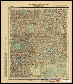
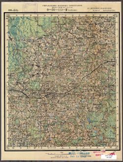
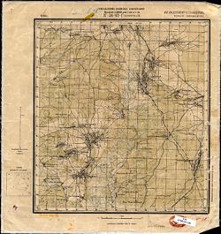
- Description:
- 1929
- Subject:
- Geographic Subject: Ostsy, Topical Subject: Soviet Union, and Topical Subject: Maps
- Publisher:
- Военно-топографическое управление
- Language:
- Russian
- Identifier:
- VAC9619-003571
- Genre:
- Topographic Maps and Military Maps
- Geographic Location:
- Coordinates: 57, 31.25, 57.167, 31.5
- Related URL:
- Download GeoTIFF: https://drive.google.com/file/d/1wTzgMw_Mf3W0MWGz0V_4RwL9nAaJXgit/view?usp=sharing and Catalog URL: http://iucat.iu.edu/catalog/5020131
- Abstract:
- Modern area represented: Осцы (Ostsy), Novgorodskaya oblast, Russia
- Call Number:
- GM G7000 s50 .S68 sheet O-36-99-D
- Caption:
- Captured map and Не подлежит оглашению
- City:
- Осцы (Ostsy)
- Copyright Holder:
- No Copyright - United States
- Country:
- СССР (USSR)
- State/Province:
- Западная область (Western oblast) and РСФСР (RSFSR)
- Physical Description:
- Scale: 1:50,000
- Persistent URL:
- http://purl.dlib.indiana.edu/iudl/images/VAC9619/VAC9619-003571
- Provenance:
- Army Map Service Library, Library of Congress G & M Division
-
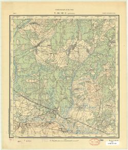
- Description:
- 1929
- Subject:
- Geographic Subject: Gorodnya, Topical Subject: Soviet Union, and Topical Subject: Maps
- Publisher:
- Военно-топографическое управление
- Language:
- Russian
- Identifier:
- VAC9619-003545
- Genre:
- Topographic Maps and Military Maps
- Geographic Location:
- Coordinates: 57.167, 31.25, 57.333, 31.5
- Related URL:
- Download GeoTIFF: https://drive.google.com/file/d/1FjmwidqkMb6yWwdQL_V2TgFIfjKpzItG/view?usp=sharing and Catalog URL: http://iucat.iu.edu/catalog/5020131
- Abstract:
- Modern area represented: Городня (Gorodnya), Novgorodskaya oblast, Russia
- Call Number:
- GM G7000 s50 .S68 sheet O-36-99-B
- Caption:
- Не подлежит оглашению and Captured map
- City:
- Городня (Gorodnya)
- Copyright Holder:
- No Copyright - United States
- Country:
- СССР (USSR)
- State/Province:
- Западная область (Western oblast), Ленинградская область (Leningrad oblast), and РСФСР (RSFSR)
- Physical Description:
- Scale: 1:50,000
- Persistent URL:
- http://purl.dlib.indiana.edu/iudl/images/VAC9619/VAC9619-003545
- Provenance:
- Army Map Service Library, OMAHA, Library of Congress Geography & Map Division
-
- Description:
- 1929
- Subject:
- Geographic Subject: Kholm, Topical Subject: Soviet Union, and Topical Subject: Maps
- Publisher:
- Военно-топографическое управление
- Language:
- Russian
- Date Created:
- 1931
- Identifier:
- VAC9619-003546
- Genre:
- Topographic Maps and Military Maps
- Geographic Location:
- Coordinates: 57, 31, 57.167, 31.25
- Related URL:
- Catalog URL: http://iucat.iu.edu/catalog/5020131 and Download GeoTIFF: https://drive.google.com/file/d/14FZ72RnG3YaQdv665_8KZieiVdZ2ESep/view?usp=sharing
- Abstract:
- Modern area represented: Холм (Kholm), Novgorodskaya oblast, Russia
- Call Number:
- GM G7000 s50 .S68 sheet O-36-99-C
- Caption:
- Не подлежит оглашению and Captured map
- City:
- Холм (Kholm)
- Copyright Holder:
- No Copyright - United States
- Country:
- СССР (USSR)
- State/Province:
- Западная область (Western oblast) and РСФСР (RSFSR)
- Physical Description:
- Scale: 1:50,000
- Persistent URL:
- http://purl.dlib.indiana.edu/iudl/images/VAC9619/VAC9619-003546
- Provenance:
- DMA Topographic Center, Army Map Service Library, Library of Congress Geography & Map Division
-
- Description:
- 1929
- Subject:
- Geographic Subject: Kamenka, Topical Subject: Soviet Union, and Topical Subject: Maps
- Publisher:
- Военно-топографическое управление
- Language:
- Russian
- Identifier:
- VAC9619-003544
- Genre:
- Topographic Maps and Military Maps
- Geographic Location:
- Coordinates: 57.167, 31, 57.333, 31.25
- Related URL:
- Download GeoTIFF: https://drive.google.com/file/d/1lmBNnLm3Poz1CI8n_BfSwm8NcQNlU4M-/view?usp=sharing and Catalog URL: http://iucat.iu.edu/catalog/5020131
- Abstract:
- Modern area represented: Каменка (Kamenka), Novgorodskaya oblast, Russia
- Call Number:
- GM G7000 s50 .S68 sheet O-36-99-A
- Caption:
- Не подлежит оглашению
- City:
- Каменка (Kamenka)
- Copyright Holder:
- No Copyright - United States
- Country:
- СССР (USSR)
- State/Province:
- РСФСР (RSFSR), Западная область (Western oblast), and Ленинградская область (Leningrad oblast)
- Physical Description:
- Scale: 1:50,000
- Persistent URL:
- http://purl.dlib.indiana.edu/iudl/images/VAC9619/VAC9619-003544
- Provenance:
- DMA Topographic Center, Army Map Service Library, Library of Congress Geography & Map Division
-
- Description:
- 1929
- Subject:
- Topical Subject: Maps, Geographic Subject: Grukhovka, and Topical Subject: Soviet Union
- Publisher:
- Военно-топографическое управление
- Language:
- Russian
- Date Created:
- 1931
- Identifier:
- VAC9619-003543
- Genre:
- Military Maps and Topographic Maps
- Geographic Location:
- Coordinates: 57, 30.75, 57.167, 31
- Related URL:
- Catalog URL: http://iucat.iu.edu/catalog/5020131 and Download GeoTIFF: https://drive.google.com/file/d/10cBEg6wt7rsu8y81pFFEQTVI_l7MGGPb/view?usp=sharing
- Abstract:
- Modern area represented: Груховка (Grukhovka), Novgorodskaya oblast, Russia
- Call Number:
- GM G7000 s50 .S68 sheet O-36-98-D
- Caption:
- Captured map and Не подлежит оглашению
- City:
- Груховка (Grukhovka)
- Copyright Holder:
- No Copyright - United States
- Country:
- СССР (USSR)
- State/Province:
- РСФСР (RSFSR) and Западная область (Western oblast)
- Physical Description:
- Scale: 1:50,000
- Persistent URL:
- http://purl.dlib.indiana.edu/iudl/images/VAC9619/VAC9619-003543
- Provenance:
- Army Map Service Library, OMAHA, Library of Congress Geography & Map Division
-
- Description:
- 1929
- Subject:
- Topical Subject: Maps, Topical Subject: Soviet Union, and Geographic Subject: Kakachevo
- Publisher:
- Военно-топографическое управление
- Language:
- Russian
- Identifier:
- VAC9619-003542
- Genre:
- Military Maps and Topographic Maps
- Geographic Location:
- Coordinates: 57.167, 30.75, 57.333, 31
- Related URL:
- Download GeoTIFF: https://drive.google.com/file/d/1YT8nZVeHKlhrNeoy8rtiqLf1NAd8Sj-v/view?usp=sharing and Catalog URL: http://iucat.iu.edu/catalog/5020131
- Abstract:
- Modern area represented: Какачево (Kakachevo), Novgorodskaya oblast, Russia
- Call Number:
- GM G7000 s50 .S68 sheet O-36-98-B
- Caption:
- Не подлежит оглашению and Captured map
- City:
- Какачево (Kakachevo)
- Copyright Holder:
- No Copyright - United States
- Country:
- СССР (USSR)
- State/Province:
- Западная область (Western oblast), РСФСР (RSFSR), and Ленинградская область (Leningrad oblast)
- Physical Description:
- Scale: 1:50,000
- Persistent URL:
- http://purl.dlib.indiana.edu/iudl/images/VAC9619/VAC9619-003542
- Provenance:
- Army Map Service Library, OMAHA, Library of Congress Geography & Map Division
-
- Description:
- 1929
- Subject:
- Topical Subject: Soviet Union, Geographic Subject: Ratcha, and Topical Subject: Maps
- Publisher:
- Военно-топографическое управление
- Language:
- Russian
- Identifier:
- VAC9619-003541
- Genre:
- Military Maps and Topographic Maps
- Geographic Location:
- Coordinates: 57.167, 30.5, 57.333, 30.75
- Related URL:
- Download GeoTIFF: https://drive.google.com/file/d/1pdcmxgXbZcHes0ODfezImWRALQDr-Qxg/view?usp=sharing and Catalog URL: http://iucat.iu.edu/catalog/5020131
- Abstract:
- Modern area represented: Ратча (Ratcha), Pskovskaya oblast, Russia
- Call Number:
- GM G7000 s50 .S68 sheet O-36-98-A
- Caption:
- Не подлежит оглашению and Captured map
- City:
- Ратча (Ratcha)
- Copyright Holder:
- No Copyright - United States
- Country:
- СССР (USSR)
- State/Province:
- РСФСР (RSFSR), Ленинградская область (Leningrad oblast), and Западная область (Western oblast)
- Physical Description:
- Scale: 1:50,000
- Persistent URL:
- http://purl.dlib.indiana.edu/iudl/images/VAC9619/VAC9619-003541
- Provenance:
- DMA Topographic Center, Army Map Service Library, OMAHA, Library of Congress Geography & Map Division
-
- Description:
- 1927
- Subject:
- Topical Subject: Soviet Union, Geographic Subject: Shoptovo, and Topical Subject: Maps
- Publisher:
- Военно-топографическое управление
- Language:
- Russian
- Identifier:
- VAC9619-003504
- Genre:
- Topographic Maps and Military Maps
- Geographic Location:
- Coordinates: 56.0, 33.0, 56.16667, 33.25
- Related URL:
- Catalog URL: http://iucat.iu.edu/catalog/5020131 and Download GeoTIFF: https://drive.google.com/file/d/1jBZ7c8YBwoL20pu6vc6Qs9-_gZvQX4Sd/view?usp=sharing
- Abstract:
- Modern area represented: Шоптово (Shoptovo), Tverskaya oblast, Russia
- Call Number:
- GM G7000 s50 .S68 sheet O-36-139-C
- City:
- Шопотово (Shopotovo)
- Copyright Holder:
- No Copyright - United States
- Country:
- СССР (USSR)
- State/Province:
- РСФСР (RSFSR) and Западная область (Western oblast)
- Physical Description:
- Scale: 1:50,000
- Persistent URL:
- http://purl.dlib.indiana.edu/iudl/images/VAC9619/VAC9619-003504
- Provenance:
- CIA Map Library
-
- Description:
- 1927
- Subject:
- Topical Subject: Soviet Union, Geographic Subject: Mezheninka, and Topical Subject: Maps
- Publisher:
- Военно-топографическое управление
- Language:
- Russian
- Identifier:
- VAC9619-003502
- Genre:
- Military Maps and Topographic Maps
- Geographic Location:
- Coordinates: 56.16667, 33.0, 56.3333, 33.25
- Related URL:
- Catalog URL: http://iucat.iu.edu/catalog/5020131 and Download GeoTIFF: https://drive.google.com/file/d/1msDwvef1CncSNMwEPY6URhxcHpecNCQ8/view?usp=sharing
- Abstract:
- Modern area represented: Меженинка (Mezheninka), Tverskaya oblast, Russia
- Call Number:
- GM G7000 s50 .S68 sheet O-36-139-A
- City:
- Межененские (Mezhenenskiye)
- Copyright Holder:
- No Copyright - United States
- Country:
- СССР (USSR)
- State/Province:
- РСФСР (RSFSR) and Западная область (Western oblast)
- Physical Description:
- Scale: 1:50,000
- Persistent URL:
- http://purl.dlib.indiana.edu/iudl/images/VAC9619/VAC9619-003502
- Provenance:
- DMA Topographic Center, Army Map Service Library, OMAHA, Library of Congress Geography & Map Division
-
- Description:
- 1927
- Subject:
- Topical Subject: Soviet Union, Topical Subject: Maps, and Geographic Subject: Antipovo
- Publisher:
- Военно-топографическое управление
- Language:
- Russian
- Identifier:
- VAC9619-003501
- Genre:
- Military Maps and Topographic Maps
- Geographic Location:
- Coordinates: 56.0, 32.75, 56.16667, 33.0
- Related URL:
- Catalog URL: http://iucat.iu.edu/catalog/5020131 and Download GeoTIFF: https://drive.google.com/file/d/17UPVPdSxwT698hAzuDjXjYF7zuw1u4my/view?usp=sharing
- Abstract:
- Modern area represented: Антипово (Antipovo), Tverskaya oblast, Russia
- Call Number:
- GM G7000 s50 .S68 sheet O-36-138-D
- Caption:
- Captured map
- City:
- Антипино (Antipino)
- Copyright Holder:
- No Copyright - United States
- Country:
- СССР (USSR)
- State/Province:
- Западная область (Western oblast) and РСФСР (RSFSR)
- Physical Description:
- Scale: 1:50,000
- Persistent URL:
- http://purl.dlib.indiana.edu/iudl/images/VAC9619/VAC9619-003501
- Provenance:
- DMA Topographic Center, Army Map Service Library, OMAHA, Library of Congress Geography & Map Division
-
- Description:
- 1927
- Subject:
- Geographic Subject: Nelidovo, Topical Subject: Soviet Union, and Topical Subject: Maps
- Publisher:
- Военно-топографическое управление
- Language:
- Russian
- Identifier:
- VAC9619-003499
- Genre:
- Military Maps and Topographic Maps
- Geographic Location:
- Coordinates: 56.167, 32.75, 56.333, 33
- Related URL:
- Download GeoTIFF: https://drive.google.com/file/d/1lyldTXRTAWh4xkvxGY4qHYiAm3I1vIe8/view?usp=sharing and Catalog URL: http://iucat.iu.edu/catalog/5020131
- Abstract:
- Modern area represented: Нелидово (Nelidovo), Tverskaya oblast, Russia
- Call Number:
- G7000 s50 .S68 sheet O-36-138-B
- Caption:
- Секретно
- City:
- Нелидово (Nelidovo)
- Copyright Holder:
- No Copyright - United States
- Country:
- СССР (USSR)
- State/Province:
- РСФСР (RSFSR) and Западная область (Western oblast)
- Physical Description:
- Scale: 1:50,000
- Persistent URL:
- http://purl.dlib.indiana.edu/iudl/images/VAC9619/VAC9619-003499
- Provenance:
- Army Map Service Library, OMAHA, Library of Congress Geography & Map Division
-
- Description:
- 1927
- Subject:
- Topical Subject: Soviet Union, Geographic Subject: Vlasovo, and Topical Subject: Maps
- Publisher:
- Военно-топографическое управление
- Language:
- Russian
- Identifier:
- VAC9619-003500
- Genre:
- Topographic Maps and Military Maps
- Geographic Location:
- Coordinates: 56.0, 32.5, 56.16667, 32.75
- Related URL:
- Download GeoTIFF: https://drive.google.com/file/d/1K43SRLCcHp7muoj_V23JS8nYEDh6zZTF/view?usp=sharing and Catalog URL: http://iucat.iu.edu/catalog/5020131
- Abstract:
- Modern area represented: Власово (Vlasovo), Tverskaya oblast, Russia
- Call Number:
- GM G7000 s50 .S68 sheet O-36-138-C
- Caption:
- Секретно
- City:
- Власово (Vlasovo)
- Copyright Holder:
- No Copyright - United States
- Country:
- СССР (USSR)
- State/Province:
- РСФСР (RSFSR) and Западная область (Western oblast)
- Physical Description:
- Scale: 1:50,000
- Persistent URL:
- http://purl.dlib.indiana.edu/iudl/images/VAC9619/VAC9619-003500
- Provenance:
- DMA Topographic Center, Army Map Service Library, OMAHA, Library of Congress Geography & Map Division
-
- Description:
- 1927
- Subject:
- Topical Subject: Maps, Geographic Subject: Pustyn’ki, and Topical Subject: Soviet Union
- Publisher:
- Управление военных топографов
- Language:
- Russian
- Identifier:
- VAC9619-003498
- Genre:
- Military Maps and Topographic Maps
- Geographic Location:
- Coordinates: 56.0, 32.25, 56.16667, 32.5
- Related URL:
- Download GeoTIFF: https://drive.google.com/file/d/1Yv9r_825jXoWaOU8ElrPqiG4PfOhsCNr/view?usp=sharing and Catalog URL: http://iucat.iu.edu/catalog/5020131
- Abstract:
- Modern area represented: Пустыньки (Pustyn'ki), Tverskaya oblast, Russia
- Call Number:
- G7000 s50 .S68 sheet O-36-137-D
- Caption:
- Не подлежит оглашению and Captured map
- City:
- Пустынки (Pustynki)
- Copyright Holder:
- No Copyright - United States
- Country:
- СССР (USSR)
- State/Province:
- Западная область (Western oblast) and РСФСР (RSFSR)
- Physical Description:
- Scale: 1:50,000
- Persistent URL:
- http://purl.dlib.indiana.edu/iudl/images/VAC9619/VAC9619-003498
- Provenance:
- Army Map Service Library, OMAHA, Library of Congress Geography & Map Division
-
- Description:
- 1927
- Subject:
- Topical Subject: Maps, Geographic Subject: Kostino, and Topical Subject: Soviet Union
- Publisher:
- Военно-топографическое управление
- Language:
- Russian
- Date Created:
- 1931
- Identifier:
- VAC9619-003496
- Genre:
- Military Maps and Topographic Maps
- Geographic Location:
- Coordinates: 56.16667, 32.25, 56.3333, 32.5
- Related URL:
- Catalog URL: http://iucat.iu.edu/catalog/5020131 and Download GeoTIFF: https://drive.google.com/file/d/1GYX8MG1pr7HLk6E4vDVjIph0M1NGD7w_/view?usp=sharing
- Abstract:
- Modern area represented: Костино (Kostino), Tverskaya oblast, Russia
- Call Number:
- G7000 s50 .S68 sheet O-36-137-B
- Caption:
- Секретно
- City:
- Костино (Kostino)
- Copyright Holder:
- No Copyright - United States
- Country:
- СССР (USSR)
- State/Province:
- Западная область (Western oblast) and РСФСР (RSFSR)
- Physical Description:
- Scale: 1:50,000
- Persistent URL:
- http://purl.dlib.indiana.edu/iudl/images/VAC9619/VAC9619-003496
- Provenance:
- CIA Map Branch -- Received
-
- Description:
- 1927
- Subject:
- Topical Subject: Soviet Union, Topical Subject: Maps, and Geographic Subject: Rudnya
- Publisher:
- Военно-топографическое управление
- Language:
- Russian
- Date Created:
- 1931
- Identifier:
- VAC9619-003497
- Genre:
- Military Maps and Topographic Maps
- Geographic Location:
- Coordinates: 56.0, 32.0, 56.16667, 32.25
- Related URL:
- Download GeoTIFF: https://drive.google.com/file/d/16Iw_-iilBMElN1C8ra9TPxFfDoK8zl3z/view?usp=sharing and Catalog URL: http://iucat.iu.edu/catalog/5020131
- Abstract:
- Modern area represented: Рудня (Rudnya), Tverskaya oblast, Russia
- Call Number:
- G7000 s50 .S68 sheet O-36-137-C
- Caption:
- Секретно
- City:
- Рудня (Rudnya)
- Copyright Holder:
- No Copyright - United States
- Country:
- СССР (USSR)
- State/Province:
- Западная область (Western oblast) and РСФСР (RSFSR)
- Physical Description:
- Scale: 1:50,000
- Persistent URL:
- http://purl.dlib.indiana.edu/iudl/images/VAC9619/VAC9619-003497
- Provenance:
- CIA Map Branch -- Received
-
- Description:
- 1927
- Subject:
- Topical Subject: Maps, Geographic Subject: Zapadnaya Dvina, and Topical Subject: Soviet Union
- Publisher:
- Управление военных топографов
- Language:
- Russian
- Identifier:
- VAC9619-003495
- Genre:
- Military Maps and Topographic Maps
- Geographic Location:
- Coordinates: 56.16667, 32.0, 56.3333, 32.25
- Related URL:
- Download GeoTIFF: https://drive.google.com/file/d/1i7dz_XUT0SGw9D_NJ6YdfUDZSYjLc8Lx/view?usp=sharing and Catalog URL: http://iucat.iu.edu/catalog/5020131
- Abstract:
- Modern area represented: Западная Двина (Zapadnaya Dvina), Tverskaya oblast, Russia
- Call Number:
- G7000 s50 .S68 sheet O-36-137-A
- Caption:
- Не подлежит оглашению
- City:
- Западная Двина (Zapadnaya Dvina)
- Copyright Holder:
- No Copyright - United States
- Country:
- СССР (USSR)
- State/Province:
- РСФСР (RSFSR) and Западная область (Western oblast)
- Physical Description:
- Scale: 1:50,000
- Persistent URL:
- http://purl.dlib.indiana.edu/iudl/images/VAC9619/VAC9619-003495
- Provenance:
- CIA Map Branch -- Received
-
- Description:
- 1927
- Subject:
- Topical Subject: Soviet Union, Geographic Subject: Kovali, and Topical Subject: Maps
- Publisher:
- Управление военных топографов
- Language:
- Russian
- Identifier:
- VAC9619-003494
- Genre:
- Topographic Maps and Military Maps
- Geographic Location:
- Coordinates: 56.0, 31.75, 56.16667, 32.0
- Related URL:
- Download GeoTIFF: https://drive.google.com/file/d/1aUs01744U8z9WJUyVwJHJ7uEfI1G5EIX/view?usp=sharing and Catalog URL: http://iucat.iu.edu/catalog/5020131
- Abstract:
- Modern area represented: Ковали (Kovali), Tverskaya oblast, Russia
- Call Number:
- G7000 s50 .S68 sheet O-36-136-D
- Caption:
- Не подлежит оглашению
- City:
- Ковали (Kovali)
- Copyright Holder:
- No Copyright - United States
- Country:
- СССР (USSR)
- State/Province:
- РСФСР (RSFSR) and Западная область (Western oblast)
- Physical Description:
- Scale: 1:50,000
- Persistent URL:
- http://purl.dlib.indiana.edu/iudl/images/VAC9619/VAC9619-003494
- Provenance:
- M. I. Map Library
-
- Description:
- 1927
- Subject:
- Geographic Subject: Semenovskoye, Topical Subject: Maps, and Topical Subject: Soviet Union
- Publisher:
- Военно-топографическое управление
- Language:
- Russian
- Identifier:
- VAC9619-003492
- Genre:
- Military Maps and Topographic Maps
- Geographic Location:
- Coordinates: 56.167, 31.75, 56.333, 32
- Related URL:
- Download GeoTIFF: https://drive.google.com/file/d/1jeayTwDfSv2qhhL-amQahbqGYgOI-mU8/view?usp=sharing and Catalog URL: http://iucat.iu.edu/catalog/5020131
- Abstract:
- Modern area represented: Семеновское (Semenovskoye), Tverskaya oblast, Russia
- Call Number:
- G7000 s50 .S68 sheet O-36-136-B
- Caption:
- Captured map and Секретно
- City:
- Семеновское (Semenovskoye)
- Copyright Holder:
- No Copyright - United States
- Country:
- СССР (USSR)
- State/Province:
- РСФСР (RSFSR) and Западная область (Western oblast)
- Physical Description:
- Scale: 1:50,000
- Persistent URL:
- http://purl.dlib.indiana.edu/iudl/images/VAC9619/VAC9619-003492
- Provenance:
- Army Map Service Library, Library of Congress Geography & Map Division
-
- Description:
- 1927
- Subject:
- Geographic Subject: Sutrimino, Topical Subject: Maps, and Topical Subject: Soviet Union
- Publisher:
- Военно-топографическое управление
- Language:
- Russian
- Date Created:
- 1931
- Identifier:
- VAC9619-003493
- Genre:
- Military Maps and Topographic Maps
- Geographic Location:
- Coordinates: 56, 31.5, 56.167, 31.75
- Related URL:
- Catalog URL: http://iucat.iu.edu/catalog/5020131 and Download GeoTIFF: https://drive.google.com/file/d/1uE3rahGvu03Kf3HjsBCnvMFHxgTLi5jl/view?usp=sharing
- Abstract:
- Modern area represented: Сутрмино (Sutrimino), Tverskaya oblast, Russia
- Call Number:
- G7000 s50 .S68 sheet O-36-136-C
- Caption:
- Captured map and Секретно
- City:
- Сутрмино (Sutrimino)
- Copyright Holder:
- No Copyright - United States
- Country:
- СССР (USSR)
- State/Province:
- РСФСР (RSFSR) and Западная область (Western oblast)
- Physical Description:
- Scale: 1:50,000
- Persistent URL:
- http://purl.dlib.indiana.edu/iudl/images/VAC9619/VAC9619-003493
- Provenance:
- Army Map Service Library, OMAHA, Library of Congress Geography & Map Division
-
- Description:
- 1926
- Subject:
- Topical Subject: Maps, Geographic Subject: Osinovka, and Topical Subject: Soviet Union
- Publisher:
- Военно-топографическое управление
- Language:
- Russian
- Identifier:
- VAC9619-003491
- Genre:
- Military Maps and Topographic Maps
- Geographic Location:
- Coordinates: 56, 31.25, 56.167, 31.5
- Related URL:
- Download GeoTIFF: https://drive.google.com/file/d/1FqjNxEe2q9VGb-MjNqD-YMmMHRNRwm4W/view?usp=sharing and Catalog URL: http://iucat.iu.edu/catalog/5020131
- Abstract:
- Modern area represented: Осиновка (Osinovka), Pskovskaya oblast, Russia
- Call Number:
- G7000 s50 .S68 sheet O-36-135-D
- Caption:
- Секретно
- City:
- Осиновка (Osinovka)
- Copyright Holder:
- No Copyright - United States
- Country:
- СССР (USSR)
- State/Province:
- РСФСР (RSFSR) and Западная область (Western oblast)
- Physical Description:
- Scale: 1:50,000
- Persistent URL:
- http://purl.dlib.indiana.edu/iudl/images/VAC9619/VAC9619-003491
- Provenance:
- DMA Topographic Center, Army Map Service Library, Library of Congress Geography & Map Division
-
- Description:
- 1926
- Subject:
- Topical Subject: Soviet Union, Topical Subject: Maps, and Geographic Subject: Zhizhitsa
- Publisher:
- Управление военных топографов
- Language:
- Russian
- Date Created:
- 1933
- Identifier:
- VAC9619-003490
- Genre:
- Topographic Maps and Military Maps
- Geographic Location:
- Coordinates: 56.167, 31.25, 56.333, 31.5
- Related URL:
- Download GeoTIFF: https://drive.google.com/file/d/1akHjhCoHjwS7M9NoqxD_Wge8T9N5pm0n/view?usp=sharing and Catalog URL: http://iucat.iu.edu/catalog/5020131
- Abstract:
- Modern area represented: Жижица (Zhizhitsa), Pskovskaya oblast, Russia
- Call Number:
- G7000 s50 .S68 sheet O-36-135-B
- Caption:
- Captured map and Не подлежит оглашению
- City:
- Жижица (Zhizhitsa)
- Copyright Holder:
- No Copyright - United States
- Country:
- СССР (USSR)
- State/Province:
- Западная область (Western oblast) and РСФСР (RSFSR)
- Physical Description:
- Scale: 1:50,000
- Persistent URL:
- http://purl.dlib.indiana.edu/iudl/images/VAC9619/VAC9619-003490
- Provenance:
- DMA Topographic Center, Army Map Service Library, OMAHA, Library of Congress Geography & Map Division
-
- Subject:
- Topical Subject: Soviet Union, Geographic Subject: Gruzdovo, and Topical Subject: Maps
- Publisher:
- Управление военных топографов
- Language:
- Russian
- Identifier:
- VAC9619-003489
- Genre:
- Military Maps and Topographic Maps
- Geographic Location:
- Coordinates: 56.167, 31, 56.333, 31.25
- Related URL:
- Catalog URL: http://iucat.iu.edu/catalog/5020131 and Download GeoTIFF: https://drive.google.com/file/d/1CMigDyHomt0Hpi1G7k_zN6Skk154K5Hw/view?usp=sharing
- Abstract:
- Modern area represented: Груздово (Gruzdovo), Pskovskaya oblast, Russia
- Call Number:
- G7000 s50 .S68 sheet O-36-135-A
- Caption:
- Не подлежит оглашению
- City:
- Груздово (Gruzdovo)
- Copyright Holder:
- No Copyright - United States
- Country:
- СССР (USSR)
- State/Province:
- Западная область (Western oblast) and РСФСР (RSFSR)
- Physical Description:
- Scale: 1:50,000
- Persistent URL:
- http://purl.dlib.indiana.edu/iudl/images/VAC9619/VAC9619-003489
- Provenance:
- DMA Topographic Center, Army Map Service Library, OMAHA, Library of Congress Geography & Map Division
-
- Description:
- 1926
- Subject:
- Topical Subject: Maps, Geographic Subject: Vsteselovo, and Topical Subject: Soviet Union
- Publisher:
- Военно-топографическое управление
- Language:
- Russian
- Identifier:
- VAC9619-003488
- Genre:
- Topographic Maps and Military Maps
- Geographic Location:
- Coordinates: 56, 30.75, 56.167, 31
- Related URL:
- Catalog URL: http://iucat.iu.edu/catalog/5020131 and Download GeoTIFF: https://drive.google.com/file/d/1J33z0365O18Sf0e9kIrm__IBnH6t-Qhx/view?usp=sharing
- Abstract:
- Modern area represented: Встеселово (Vsteselovo), Pskovskaya oblast, Russia
- Call Number:
- G7000 s50 .S68 sheet O-36-134-D
- Caption:
- Не подлежит оглашению
- City:
- Встеселово (Vsteselovo)
- Copyright Holder:
- No Copyright - United States
- Country:
- СССР (USSR)
- State/Province:
- Западная область (Western oblast) and РСФСР (RSFSR)
- Physical Description:
- Scale: 1:50,000
- Persistent URL:
- http://purl.dlib.indiana.edu/iudl/images/VAC9619/VAC9619-003488
- Provenance:
- DMA Topographic Center, Army Map Service Library, OMAHA, Library of Congress Geography & Map Division
-
- Description:
- 1928
- Subject:
- Topical Subject: Soviet Union, Topical Subject: Maps, and Geographic Subject: Zaruchev’ye
- Publisher:
- Военно-топографическое управление
- Language:
- Russian
- Identifier:
- VAC9619-003487
- Genre:
- Military Maps and Topographic Maps
- Geographic Location:
- Coordinates: 56, 30.5, 56.167, 30.75
- Related URL:
- Catalog URL: http://iucat.iu.edu/catalog/5020131 and Download GeoTIFF: https://drive.google.com/file/d/1sZvT1aSi1X-gztb-fetgX7GjTlx1OctD/view?usp=sharing
- Abstract:
- Modern area represented: Заручевье (Zaruchev’ye), Pskovskaya oblast, Russia
- Call Number:
- G7000 s50 .S68 sheet O-36-134-С
- Caption:
- Секретно
- City:
- Заручевье (Zaruchev’ye)
- Copyright Holder:
- No Copyright - United States
- Country:
- СССР (USSR)
- State/Province:
- Западная область (Western oblast) and РСФСР (RSFSR)
- Physical Description:
- Scale: 1:50,000
- Persistent URL:
- http://purl.dlib.indiana.edu/iudl/images/VAC9619/VAC9619-003487
- Provenance:
- DMA Topographic Center, Army Map Service Library, OMAHA, Library of Congress Geography & Map Division
-
- Description:
- 1928
- Subject:
- Topical Subject: Soviet Union, Geographic Subject: Zadezha, and Topical Subject: Maps
- Publisher:
- Военно-топографическое управление
- Language:
- Russian
- Identifier:
- VAC9619-003486
- Genre:
- Topographic Maps and Military Maps
- Geographic Location:
- Coordinates: 56.167, 30.5, 56.333, 30.75
- Related URL:
- Catalog URL: http://iucat.iu.edu/catalog/5020131 and Download GeoTIFF: https://drive.google.com/file/d/1BBdeav3jC7XdQPWsClGL0rPZ8l48vS3Q/view?usp=sharing
- Abstract:
- Modern area represented: Задежа (Zadezha), Pskovskaya oblast, Russia
- Call Number:
- G7000 s50 .S68 sheet O-36-134-A
- Caption:
- Captured map and Секретно
- City:
- Задежа (Zadezha)
- Copyright Holder:
- No Copyright - United States
- Country:
- СССР (USSR)
- State/Province:
- РСФСР (RSFSR) and Западная область (Western oblast)
- Physical Description:
- Scale: 1:50,000
- Persistent URL:
- http://purl.dlib.indiana.edu/iudl/images/VAC9619/VAC9619-003486
- Provenance:
- DMA Topographic Center, Army Map Service Library, OMAHA, Library of Congress Geography & Map Division
-
- Subject:
- Topical Subject: Maps, Geographic Subject: Mordovichi, and Topical Subject: Soviet Union
- Publisher:
- Военно-топографическое управление
- Language:
- Russian
- Identifier:
- VAC9619-003481
- Genre:
- Military Maps and Topographic Maps
- Geographic Location:
- Coordinates: 56.167, 30.25, 56.333, 30.5
- Related URL:
- Download GeoTIFF: https://drive.google.com/file/d/1sY6hntrqKdah00xa6GFpl1pQ1wwGGLia/view?usp=sharing and Catalog URL: http://iucat.iu.edu/catalog/5020131
- Abstract:
- Modern area represented: Мордовичи (Mordovichi), Pskovskaya oblast, Russia
- Call Number:
- G7000 s50 .S68 sheet O-36-133-B
- Caption:
- Не подлежит оглашению
- City:
- Мордовищи (Mordovishchi)
- Copyright Holder:
- No Copyright - United States
- Country:
- СССР (USSR)
- State/Province:
- Западная область (Western oblast) and РСФСР (RSFSR)
- Physical Description:
- Scale: 1:50,000
- Persistent URL:
- http://purl.dlib.indiana.edu/iudl/images/VAC9619/VAC9619-003481
- Provenance:
- M. I. Map Library
-

- Subject:
- Topical Subject: Soviet Union, Geographic Subject: Trushkovo, and Topical Subject: Maps
- Publisher:
- Управление военных топографов
- Language:
- Russian
- Date Created:
- 1931
- Identifier:
- VAC9619-003483
- Genre:
- Military Maps and Topographic Maps
- Geographic Location:
- Coordinates: 56, 30, 56.167, 30.25
- Related URL:
- Download GeoTIFF: https://drive.google.com/file/d/1F9AHdWYQlqmtkTiBR4olg1MOZEsEhO3c/view?usp=sharing and Catalog URL: http://iucat.iu.edu/catalog/5020131
- Abstract:
- Modern area represented: Трушково (Trushkovo), Pskovskaya oblast, Russia
- Call Number:
- G7000 s50 .S68 sheet O-36-133-C
- Caption:
- Не подлежит оглашению
- City:
- Трушкова (Trushkova)
- Copyright Holder:
- No Copyright - United States
- Country:
- СССР (USSR)
- State/Province:
- Западная область (Western oblast) and РСФСР (RSFSR)
- Physical Description:
- Scale: 1:50,000
- Persistent URL:
- http://purl.dlib.indiana.edu/iudl/images/VAC9619/VAC9619-003483
- Provenance:
- M. I. Map Library
-
- Description:
- 1926
- Subject:
- Geographic Subject: Vysokoye, Topical Subject: Maps, and Topical Subject: Soviet Union
- Publisher:
- Управление военных топографов
- Language:
- Russian
- Date Created:
- 1933
- Identifier:
- VAC9619-003462
- Genre:
- Topographic Maps and Military Maps
- Geographic Location:
- Coordinates: 56.333, 31.25, 56.5, 31.5
- Related URL:
- Download GeoTIFF: https://drive.google.com/file/d/1tidCd1WzQh7iMs7Mrr31FLldj-CyVjKl/view?usp=sharing and Catalog URL: http://iucat.iu.edu/catalog/5020131
- Abstract:
- Modern area represented: Высокое (Vysokoye), Tverskaya oblast, Russia
- Call Number:
- GM G7000 s50 .S68 sheet O-36-123-D
- Caption:
- Не подлежит оглашению
- City:
- Лошаеды (Loshayedy)
- Copyright Holder:
- No Copyright - United States
- Country:
- СССР (USSR)
- State/Province:
- Западная область (Western oblast) and РСФСР (RSFSR)
- Physical Description:
- Scale: 1:50,000
- Persistent URL:
- http://purl.dlib.indiana.edu/iudl/images/VAC9619/VAC9619-003462
- Provenance:
- M. I. Map Library, Library of Congress Geography & Map Division
-
- Description:
- 1929
- Subject:
- Topical Subject: Soviet Union, Topical Subject: Maps, and Geographic Subject: Pozhnya
- Publisher:
- Управление военных топографов
- Language:
- Russian
- Identifier:
- VAC9619-003460
- Genre:
- Military Maps and Topographic Maps
- Geographic Location:
- Coordinates: 56.5, 31.25, 56.667, 31.5
- Related URL:
- Catalog URL: http://iucat.iu.edu/catalog/5020131 and Download GeoTIFF: https://drive.google.com/file/d/1o1jzgZnaCM3LKgtKnLRkAVWh_75Saf4b/view?usp=sharing
- Abstract:
- This place does not exist anymore. The nearest populated place is Пожня (Pozhnya), Tverskaya oblast, Russia
- Call Number:
- GM G7000 s50 .S68 sheet O-36-123-B
- Caption:
- Captured map and Не подлежит оглашению
- City:
- Стрелицы (Strelitsy)
- Copyright Holder:
- No Copyright - United States
- Country:
- СССР (USSR)
- State/Province:
- Западная область (Western oblast) and РСФСР (RSFSR)
- Physical Description:
- Scale: 1:50,000
- Persistent URL:
- http://purl.dlib.indiana.edu/iudl/images/VAC9619/VAC9619-003460
- Provenance:
- Army Map Service Library, OMAHA
-
- Subject:
- Geographic Subject: Sheykino, Topical Subject: Soviet Union, and Topical Subject: Maps
- Publisher:
- Управление военных топографов
- Language:
- Russian
- Date Created:
- 1933
- Identifier:
- VAC9619-003461
- Genre:
- Topographic Maps and Military Maps
- Geographic Location:
- Coordinates: 56.333, 31, 56.5, 31.25
- Related URL:
- Catalog URL: http://iucat.iu.edu/catalog/5020131 and Download GeoTIFF: https://drive.google.com/file/d/1fjd216-PEi63ervxn65sPkj51GMPE7fJ/view?usp=sharing
- Abstract:
- Modern area represented: Шейкино (Sheykino), Pskovskaya oblast, Russia
- Call Number:
- GM G7000 s50 .S68 sheet O-36-123-C
- Caption:
- Не подлежит оглашению
- City:
- Шейкино (Sheykino)
- Copyright Holder:
- No Copyright - United States
- Country:
- СССР (USSR)
- State/Province:
- РСФСР (RSFSR) and Западная область (Western oblast)
- Physical Description:
- Scale: 1:50,000
- Persistent URL:
- http://purl.dlib.indiana.edu/iudl/images/VAC9619/VAC9619-003461
- Provenance:
- M. I. Map Library, Justus Perthes Kartensammlung
-
- Description:
- 1929
- Subject:
- Topical Subject: Soviet Union, Geographic Subject: Ozerets, and Topical Subject: Maps
- Publisher:
- Военно-топографическое управление
- Language:
- Russian
- Identifier:
- VAC9619-003459
- Genre:
- Military Maps and Topographic Maps
- Geographic Location:
- Coordinates: 56.5, 31, 56.667, 31.25
- Related URL:
- Download GeoTIFF: https://drive.google.com/file/d/1cT42mzGQhuJLOzygRkkFgj1IWXSdrEVz/view?usp=sharing and Catalog URL: http://iucat.iu.edu/catalog/5020131
- Abstract:
- Modern area represented: Озерец (Ozerets), Tverskaya oblast, Russia
- Call Number:
- GM G7000 s50 .S68 sheet O-36-123-A
- Caption:
- Captured map
- City:
- Озерец (Ozerets)
- Copyright Holder:
- No Copyright - United States
- Country:
- СССР (USSR)
- State/Province:
- Западная область (Western oblast) and РСФСР (RSFSR)
- Physical Description:
- Scale: 1:50,000
- Persistent URL:
- http://purl.dlib.indiana.edu/iudl/images/VAC9619/VAC9619-003459
- Provenance:
- Army Map Service Library, OMAHA, Library of Congress Geography & Map Division
-
- Description:
- 1929
- Subject:
- Geographic Subject: Losevo, Topical Subject: Maps, and Topical Subject: Soviet Union
- Publisher:
- Военно-топографическое управление
- Language:
- Russian
- Identifier:
- VAC9619-003456
- Genre:
- Military Maps and Topographic Maps
- Geographic Location:
- Coordinates: 56.5, 30.75, 56.667, 31
- Related URL:
- Download GeoTIFF: https://drive.google.com/file/d/1mCc7mDbIMU7d0awqcp0m037ofjOFPAeZ/view?usp=sharing and Catalog URL: http://iucat.iu.edu/catalog/5020131
- Abstract:
- Modern area represented: Лосево (Losevo), Pskovskaya oblast, Russia
- Call Number:
- GM G7000 s50 .S68 sheet O-36-122-B
- Caption:
- Не подлежит оглашению and Captured map
- City:
- Лосево (Losevo)
- Copyright Holder:
- No Copyright - United States
- Country:
- СССР (USSR)
- State/Province:
- РСФСР (RSFSR) and Западная область (Western oblast)
- Physical Description:
- Scale: 1:50,000
- Persistent URL:
- http://purl.dlib.indiana.edu/iudl/images/VAC9619/VAC9619-003456
- Provenance:
- Army Map Service Library, OMAHA, Library of Congress Geography & Map Division
-
- Description:
- 1928
- Subject:
- Topical Subject: Maps, Geographic Subject: Velikiye Luki, and Topical Subject: Soviet Union
- Publisher:
- Военно-топографическое управление
- Language:
- Russian
- Identifier:
- VAC9619-003457
- Genre:
- Topographic Maps and Military Maps
- Geographic Location:
- Coordinates: 56.333, 30.5, 56.5, 30.75
- Related URL:
- Download GeoTIFF: https://drive.google.com/file/d/1DV1mP350rw_AJEbcbKbZFpOVZkStCKS6/view?usp=sharing and Catalog URL: http://iucat.iu.edu/catalog/5020131
- Abstract:
- Modern area represented: Великие Луки (Velikiye Luki), Pskovskaya oblast, Russia
- Call Number:
- GM G7000 s50 .S68 sheet O-36-122-C
- Caption:
- Секретно
- City:
- Великие Луки (Velikiye Luki)
- Copyright Holder:
- No Copyright - United States
- Country:
- СССР (USSR)
- State/Province:
- Западная область (Western oblast) and РСФСР (RSFSR)
- Physical Description:
- Scale: 1:50,000
- Persistent URL:
- http://purl.dlib.indiana.edu/iudl/images/VAC9619/VAC9619-003457
- Provenance:
- Army Map Service Library, OMAHA, Library of Congress Geography & Map Division
-
- Description:
- 1929
- Subject:
- Geographic Subject: Yamno, Topical Subject: Maps, and Topical Subject: Soviet Union
- Publisher:
- Управление военных топографов
- Language:
- Russian
- Identifier:
- VAC9619-003455
- Genre:
- Topographic Maps and Military Maps
- Geographic Location:
- Coordinates: 56.5, 30.5, 56.667, 30.75
- Related URL:
- Download GeoTIFF: https://drive.google.com/file/d/10tCV2tBCoSxmA7UTGYuqXbgnplyPQ7ZJ/view?usp=sharing and Catalog URL: http://iucat.iu.edu/catalog/5020131
- Abstract:
- Modern area represented: Ямно (Yamno), Pskovskaya oblast, Russia
- Call Number:
- GM G7000 s50 .S68 sheet O-36-122-A
- Caption:
- Не подлежит оглашению
- City:
- Ямна (Yamna)
- Copyright Holder:
- No Copyright - United States
- Country:
- СССР (USSR)
- State/Province:
- Западная область (Western oblast) and РСФСР (RSFSR)
- Physical Description:
- Scale: 1:50,000
- Persistent URL:
- http://purl.dlib.indiana.edu/iudl/images/VAC9619/VAC9619-003455
- Provenance:
- DMA Topographic Center, Army Map Service Library, Library of Congress Geography & Map Division
-
- Subject:
- Topical Subject: Soviet Union, Geographic Subject: Novosokol'niki, and Topical Subject: Maps
- Publisher:
- Управление военных топографов
- Language:
- Russian
- Identifier:
- VAC9619-003452
- Genre:
- Military Maps and Topographic Maps
- Geographic Location:
- Coordinates: 56.333, 30, 56.5, 30.25
- Related URL:
- Catalog URL: http://iucat.iu.edu/catalog/5020131 and Download GeoTIFF: https://drive.google.com/file/d/1gaXgS-FU0XLVESFIImmZDPBMjVcF6kYx/view?usp=sharing
- Abstract:
- Modern area represented: Новосокольники (Novosokol'niki), Pskovskaya oblast, Russia
- Call Number:
- GM G7000 s50 .S68 sheet O-36-121-C
- Caption:
- Не подлежит оглашению
- City:
- Новосокольники (Novosokol'niki)
- Copyright Holder:
- No Copyright - United States
- Country:
- СССР (USSR)
- State/Province:
- Западная область (Western oblast) and РСФСР (RSFSR)
- Physical Description:
- Scale: 1:50,000
- Persistent URL:
- http://purl.dlib.indiana.edu/iudl/images/VAC9619/VAC9619-003452
- Provenance:
- Army Map Service Library, OMAHA, Library of Congress Geography & Map Division, Property of German Military Doc. Sect. Dept. Records Br., AGO, D/A
-
- Description:
- 1929
- Subject:
- Geographic Subject: Staroye, Topical Subject: Maps, and Topical Subject: Soviet Union
- Publisher:
- Военно-топографическое управление
- Language:
- Russian
- Identifier:
- VAC9619-002883
- Genre:
- Topographic Maps and Military Maps
- Geographic Location:
- Coordinates: 56.667, 31, 56.833, 31.25
- Related URL:
- Catalog URL: http://iucat.iu.edu/catalog/5020131 and Download GeoTIFF: https://drive.google.com/file/d/1qZnU3nJ67toU9cqV6GIqsUl1E8TDZgj_/view?usp=sharing
- Abstract:
- Modern area represented: Старое (Staroye), Tverskaya oblast, Russia
- Call Number:
- GM G7000 s50 .S68 sheet O-36-111-С
- Caption:
- Captured map
- City:
- Старая (Staraya)
- Copyright Holder:
- No Copyright - United States
- Country:
- СССР (USSR)
- State/Province:
- РСФСР (RSFSR) and Западная область (Western oblast)
- Physical Description:
- Scale: 1:50,000
- Persistent URL:
- http://purl.dlib.indiana.edu/iudl/images/VAC9619/VAC9619-002883
- Provenance:
- Army Map Service Library, OMAHA, Library of Congress Geography & Map Division
-
- Description:
- 1929
- Subject:
- Geographic Subject: Baranosovo, Topical Subject: Soviet Union, and Topical Subject: Maps
- Publisher:
- Военно-топографическое управление
- Language:
- Russian
- Identifier:
- VAC9619-002881
- Genre:
- Topographic Maps and Military Maps
- Geographic Location:
- Coordinates: 56.833, 31, 57, 31.25
- Related URL:
- Download GeoTIFF: https://drive.google.com/file/d/1cDtxM3X3FImj9xCn0yL-b9dpNcA42kaY/view?usp=sharing and Catalog URL: http://iucat.iu.edu/catalog/5020131
- Abstract:
- Modern area represented: Бараносово (Baranosovo), Pskovskaya oblast, Russia
- Call Number:
- GM G7000 s50 .S68 sheet O-36-111-A
- Caption:
- Не подлежит оглашению and Captured map
- City:
- Бараносово (Baranosovo)
- Copyright Holder:
- No Copyright - United States
- Country:
- СССР (USSR)
- State/Province:
- Западная область (Western oblast) and РСФСР (RSFSR)
- Physical Description:
- Scale: 1:50,000
- Persistent URL:
- http://purl.dlib.indiana.edu/iudl/images/VAC9619/VAC9619-002881
- Provenance:
- DMA Topographic Center, Army Map Service Library, OMAHA, Library of Congress Geography & Map Division
-
- Description:
- 1929
- Subject:
- Topical Subject: Soviet Union, Topical Subject: Maps, and Geographic Subject: Usvyatovo
- Publisher:
- Военно-топографическое управление
- Language:
- Russian
- Identifier:
- VAC9619-002880
- Genre:
- Military Maps and Topographic Maps
- Geographic Location:
- Coordinates: 56.667, 30.75, 56.833, 31
- Related URL:
- Download GeoTIFF: https://drive.google.com/file/d/1rxh9thlIRzGiHkrigs5zagOh4AaRUUW3/view?usp=sharing and Catalog URL: http://iucat.iu.edu/catalog/5020131
- Abstract:
- Modern area represented: Усвятово (Usvyatovo), Tverskaya oblast, Russia
- Call Number:
- GM G7000 s50 .S68 sheet O-36-110-D
- Caption:
- Captured map and Не подлежит оглашению
- City:
- Усвятово (Usvyatovo)
- Copyright Holder:
- No Copyright - United States
- Country:
- СССР (USSR)
- State/Province:
- РСФСР (RSFSR) and Западная область (Western oblast)
- Physical Description:
- Scale: 1:50,000
- Persistent URL:
- http://purl.dlib.indiana.edu/iudl/images/VAC9619/VAC9619-002880
- Provenance:
- Army Map Service Library, OMAHA, Library of Congress Geography & Map Division
-
- Description:
- 1929
- Subject:
- Geographic Subject: Udino, Topical Subject: Maps, and Topical Subject: Soviet Union
- Publisher:
- Управление военных топографов
- Language:
- Russian
- Identifier:
- VAC9619-002879
- Genre:
- Military Maps and Topographic Maps
- Geographic Location:
- Coordinates: 56.667, 30.5, 56.833, 30.75
- Related URL:
- Download GeoTIFF: https://drive.google.com/file/d/1qMWL_kQqT8zq51Mwzie6EdtMyFNLyhNP/view?usp=sharing and Catalog URL: http://iucat.iu.edu/catalog/5020131
- Abstract:
- Modern area represented: Удино (Udino), Pskovskaya oblast, Russia
- Call Number:
- GM G7000 s50 .S68 sheet O-36-110-C
- Caption:
- Не подлежит оглашению and Captured map
- City:
- Удино (Udino)
- Copyright Holder:
- No Copyright - United States
- Country:
- СССР (USSR)
- State/Province:
- РСФСР (RSFSR) and Западная область (Western oblast)
- Physical Description:
- Scale: 1:50,000
- Persistent URL:
- http://purl.dlib.indiana.edu/iudl/images/VAC9619/VAC9619-002879
- Provenance:
- DMA Topographic Center, Army Map Service Library, Library of Congress Geography & Map Division
-
- Subject:
- Topical Subject: Maps, Topical Subject: Soviet Union, and Geographic Subject: Yukhovo
- Publisher:
- Управление военных топографов
- Language:
- Russian
- Identifier:
- VAC9619-002875
- Genre:
- Military Maps and Topographic Maps
- Geographic Location:
- Coordinates: 56.833, 30.25, 57, 30.5
- Related URL:
- Download GeoTIFF: https://drive.google.com/file/d/1MG0yuebNlbjIZ6nAn8ieGGwoY5Ktxu8E/view?usp=sharing and Catalog URL: http://iucat.iu.edu/catalog/5020131
- Abstract:
- Modern area represented: Юхово (Yukhovo), Pskovskaya oblast, Russia
- Call Number:
- GM G7000 s50 .S68 sheet O-36-109-B
- Caption:
- Не подлежит оглашению
- City:
- Юхово (Yukhovo)
- Copyright Holder:
- No Copyright - United States
- Country:
- СССР (USSR)
- State/Province:
- Западная область (Western oblast) and РСФСР (RSFSR)
- Physical Description:
- Scale: 1:50,000
- Persistent URL:
- http://purl.dlib.indiana.edu/iudl/images/VAC9619/VAC9619-002875
- Provenance:
- Army Map Service Library, OMAHA, Library of Congress Geography & Map Division
-
- Description:
- 1929
- Subject:
- Geographic Subject: Krasnyy Bor, Topical Subject: Maps, and Topical Subject: Soviet Union
- Publisher:
- Военно-топографическое управление
- Language:
- Russian
- Identifier:
- VAC9619-002878
- Genre:
- Military Maps and Topographic Maps
- Geographic Location:
- Coordinates: 56.833, 30.75, 57, 31
- Related URL:
- Download GeoTIFF: https://drive.google.com/file/d/1tRP6vA30sltgAeBoQYIW9qfHTR-CT4XL/view?usp=sharing and Catalog URL: http://iucat.iu.edu/catalog/5020131
- Abstract:
- Modern area represented: Красный Бор (Krasnyy Bor), Novgorodskaya oblast, Russia
- Call Number:
- GM G7000 s50 .S68 sheet O-36-100-B
- City:
- Поколоты (Pokoloty)
- Copyright Holder:
- No Copyright - United States
- Country:
- СССР (USSR)
- State/Province:
- Западная область (Western oblast) and РСФСР (RSFSR)
- Physical Description:
- Scale: 1:50,000
- Persistent URL:
- http://purl.dlib.indiana.edu/iudl/images/VAC9619/VAC9619-002878
- Provenance:
- DMA Topographic Center, Army Map Service Library, OMAHA, Library of Congress Geography & Map Division
-
- Description:
- 1928
- Subject:
- Topical Subject: Maps, Geographic Subject: Perelazy, and Topical Subject: Soviet Union
- Publisher:
- Военно-топографическое управление
- Language:
- Russian
- Identifier:
- VAC9619-001492
- Genre:
- Military Maps and Topographic Maps
- Geographic Location:
- Coordinates: 53, 31.25, 53.1667, 31.5
- Related URL:
- Download GeoTIFF: https://drive.google.com/open?id=1ENiuALuDhQhhmTPCP9izmCTMfCtZ8nYe and Catalog URL: http://iucat.iu.edu/catalog/5020131
- Abstract:
- Modern area represented: Perelazy, Bryansk oblast, Russia
- Call Number:
- G7000 s50 .S68 sheet N-36-99-D
- Caption:
- Секретно
- City:
- Перелазы (Perelazy)
- Copyright Holder:
- No Copyright - United States
- Country:
- СССР (USSR)
- State/Province:
- РСФСР (RSFSR), Западная область (Western oblast), and Белорусская ССР (Byelorussian Soviet Socialist Republic)
- Physical Description:
- Scale: 1:50,000
- Persistent URL:
- http://purl.dlib.indiana.edu/iudl/images/VAC9619/VAC9619-001492
- Provenance:
- DMA Topographic Center, Army Map Service Library, OMAHA, Library of Congress Geography & Map Division
-
- Description:
- 1930
- Subject:
- Geographic Subject: Ogor, Topical Subject: Soviet Union, and Topical Subject: Maps
- Publisher:
- Генеральный штаб РККА
- Language:
- Russian
- Identifier:
- VAC9619-001467
- Genre:
- Military Maps and Topographic Maps
- Geographic Location:
- Coordinates: 53.3333, 34.5, 53.5, 34.75
- Related URL:
- Download GeoTIFF: https://drive.google.com/open?id=1z8Szky-2BN4VYpKe91aBjVJdTlFW2w8J and Catalog URL: http://iucat.iu.edu/catalog/5020131
- Abstract:
- Modern area represented: Ogor, Kaluga, Russia
- Call Number:
- G7000 s50 .S68 sheet N-36-94-C
- City:
- Огорь (Ogor)
- Copyright Holder:
- No Copyright - United States
- Country:
- СССР (USSR)
- State/Province:
- РСФСР (RSFSR) and Западная область (Western oblast)
- Physical Description:
- Scale: 1:50,000
- Persistent URL:
- http://purl.dlib.indiana.edu/iudl/images/VAC9619/VAC9619-001467
- Provenance:
- DMA Topographic Center, Army Map Service Library, OMAHA, Library of Congress Geography & Map Division
-
- Description:
- 1930
- Subject:
- Geographic Subject: Boyanovichi, Topical Subject: Maps, and Topical Subject: Soviet Union
- Publisher:
- Генеральный штаб РККА
- Language:
- Russian
- Identifier:
- VAC9619-001468
- Genre:
- Military Maps and Topographic Maps
- Geographic Location:
- Coordinates: 53.3333, 34.75, 53.5, 35
- Related URL:
- Catalog URL: http://iucat.iu.edu/catalog/5020131 and Download GeoTIFF: https://drive.google.com/open?id=1DREx2N3APY6G30YlAAt889SzguoUBH-8
- Abstract:
- Modern area represented: Boyanovichi, Kaluga, Russia
- Call Number:
- G7000 s50 .S68 sheet N-36-94-D
- City:
- Буяновичи (Boyanovichi)
- Copyright Holder:
- No Copyright - United States
- Country:
- СССР (USSR)
- State/Province:
- РСФСР (RSFSR) and Западная область (Western oblast)
- Physical Description:
- Scale: 1:50,000
- Persistent URL:
- http://purl.dlib.indiana.edu/iudl/images/VAC9619/VAC9619-001468
- Provenance:
- DMA Topographic Center, Army Map Service Library, OMAHA, Library of Congress Geography & Map Division
-
- Description:
- 1930
- Subject:
- Geographic Subject: Podbuzhye, Topical Subject: Soviet Union, and Topical Subject: Maps
- Publisher:
- Управление военных топографов
- Language:
- Russian
- Identifier:
- VAC9619-001466
- Genre:
- Topographic Maps and Military Maps
- Geographic Location:
- Coordinates: 53.5, 34.75, 53.6667, 35
- Related URL:
- Catalog URL: http://iucat.iu.edu/catalog/5020131 and Download GeoTIFF: https://drive.google.com/open?id=1Eww5StjrX-Dqvf6ITLq-G9SIVbI7CZbV
- Abstract:
- Modern area represented: Podbuzhye, Kaluga, Russia
- Call Number:
- G7000 s50 .S68 sheet N-36-94-B
- Caption:
- Не подлежит оглашению
- City:
- Подбужье (Podbuzhye)
- Copyright Holder:
- No Copyright - United States
- Country:
- СССР (USSR)
- State/Province:
- РСФСР (RSFSR) and Западная область (Western oblast)
- Physical Description:
- Scale: 1:50,000
- Persistent URL:
- http://purl.dlib.indiana.edu/iudl/images/VAC9619/VAC9619-001466
- Provenance:
- Army Map Service Library, Library of Congress Geography & Map Division, OMAHA
-

- Description:
- 1930
- Subject:
- Geographic Subject: Uleml, Topical Subject: Maps, and Topical Subject: Soviet Union
- Publisher:
- Генеральный штаб Красной Армии
- Language:
- Russian
- Identifier:
- VAC9619-001465
- Genre:
- Topographic Maps and Military Maps
- Geographic Location:
- Coordinates: 53.5, 34.5, 53.6667, 34.75
- Related URL:
- Catalog URL: http://iucat.iu.edu/catalog/5020131 and Download GeoTIFF: https://drive.google.com/open?id=1U2PXzsrgKahBGHM3IuYx6EP5TM3z_EsH
- Abstract:
- Modern area represented: Uleml, Kaluga, Russia
- Call Number:
- G7000 s50 .S68 sheet N-36-94-A
- City:
- Улемль (Uleml)
- Copyright Holder:
- No Copyright - United States
- Country:
- СССР (USSR)
- State/Province:
- Западная область (Western oblast) and РСФСР (RSFSR)
- Physical Description:
- Scale: 1:50,000
- Persistent URL:
- http://purl.dlib.indiana.edu/iudl/images/VAC9619/VAC9619-001465
- Provenance:
- Army Map Service Library, Library of Congress Geography & Map Division, OMAHA
-
- Description:
- 1930
- Subject:
- Topical Subject: Maps, Topical Subject: Soviet Union, and Geographic Subject: Tsementniy
- Publisher:
- Управление военных топографов
- Language:
- Russian
- Identifier:
- VAC9619-001464
- Genre:
- Topographic Maps and Military Maps
- Geographic Location:
- Coordinates: 53.333333, 34.25, 53.5, 34.5
- Related URL:
- Catalog URL: http://iucat.iu.edu/catalog/5020131 and Download GeoTIFF: https://drive.google.com/open?id=1_hLet8LTbNamOAFJkTRu0yxEhS2JXJ71
- Abstract:
- Modern area represented: Tsementniy, Russia
- Call Number:
- G7000 s50 .S68 sheet N-36-93-D
- Caption:
- Не подлежит оглашению
- City:
- Цементный (Tsementniy)
- Copyright Holder:
- No Copyright - United States
- Country:
- СССР (USSR)
- State/Province:
- РСФСР (RSFSR) and Западная область (Western oblast)
- Physical Description:
- Scale: 1:50,000
- Persistent URL:
- http://purl.dlib.indiana.edu/iudl/images/VAC9619/VAC9619-001464
- Provenance:
- Library of Congress Geography & Map Division
-
- Description:
- 1930
- Subject:
- Geographic Subject: Dorozhovo, Topical Subject: Soviet Union, and Topical Subject: Maps
- Publisher:
- Генеральный штаб РККА
- Language:
- Russian
- Identifier:
- VAC9619-001458
- Genre:
- Topographic Maps and Military Maps
- Geographic Location:
- Coordinates: 53.3333, 34, 53.5, 34.25
- Related URL:
- Catalog URL: http://iucat.iu.edu/catalog/5020131 and Download GeoTIFF: https://drive.google.com/open?id=1BYCAZEWtRh1BqxrBTrB9jFx29DVLXjx5
- Abstract:
- Modern area represented: Dorozhovo, Bryansk oblast, Russia
- Call Number:
- G7000 s50 .S68 sheet N-36-93-C
- City:
- Дорожова (Dorozhovo)
- Copyright Holder:
- No Copyright - United States
- Country:
- СССР (USSR)
- State/Province:
- Западная область (Western oblast) and РСФСР (RSFSR)
- Physical Description:
- Scale: 1:50,000
- Persistent URL:
- http://purl.dlib.indiana.edu/iudl/images/VAC9619/VAC9619-001458
- Provenance:
- DMA Topographic Center, Army Map Service Library, OMAHA, Library of Congress Geography & Map Division
-
- Description:
- 1930
- Subject:
- Geographic Subject: Dorozhovo, Topical Subject: Soviet Union, and Topical Subject: Maps
- Publisher:
- Генеральный штаб РККА
- Language:
- Russian
- Identifier:
- VAC9619-001462
- Genre:
- Topographic Maps and Military Maps
- Geographic Location:
- Coordinates: 53.333, 34, 53.5, 34.25
- Related URL:
- Catalog URL: http://iucat.iu.edu/catalog/5020131 and Download GeoTIFF: https://drive.google.com/file/d/1IoKkocKFWbu6Qc0u_yyNg9Xyt_t7bcRx/view?usp=sharing
- Abstract:
- Modern area represented: Dorozhovo, Bryansk oblast, Russia
- Call Number:
- G7000 s50 .S68 sheet N-36-93-В
- City:
- Дорожова (Dorozhova)
- Copyright Holder:
- No Copyright - United States
- Country:
- СССР (USSR)
- State/Province:
- РСФСР (RSFSR) and Западная область (Western oblast)
- Physical Description:
- Scale: 1:50,000
- Persistent URL:
- http://purl.dlib.indiana.edu/iudl/images/VAC9619/VAC9619-001462
- Provenance:
- Library of Congress Geography & Map Division
-
- Description:
- 1930
- Subject:
- Topical Subject: Maps, Topical Subject: Soviet Union, and Geographic Subject: Star
- Publisher:
- Генеральный штаб Красной Армии
- Language:
- Russian
- Identifier:
- VAC9619-001457
- Genre:
- Topographic Maps and Military Maps
- Geographic Location:
- Coordinates: 53.5, 34, 53.6667, 34.25
- Related URL:
- Catalog URL: http://iucat.iu.edu/catalog/5020131 and Download GeoTIFF: https://drive.google.com/open?id=1cwSkU0O5TqIj_1CEnBGyBnuygl-HrYzx
- Abstract:
- Modern area represented: Star, Russia
- Call Number:
- GM G7000 S50 .S68 N-36-93-A
- City:
- Старь (Star)
- Copyright Holder:
- No Copyright - United States
- Country:
- СССР (USSR)
- State/Province:
- РСФСР (RSFSR) and Западная область (Western oblast)
- Physical Description:
- Scale: 1:50,000
- Persistent URL:
- http://purl.dlib.indiana.edu/iudl/images/VAC9619/VAC9619-001457
- Provenance:
- Army Map Service Library, Library of Congress Geography & Map Division, OMAHA

- « Previous
- Next »
- 1
- 2
- 3
- 4