Schneider, Allan F. (Allan Frank), 1926-, Gooding, Ansel Miller, Forsyth, Jane L. (Jane Louise), 1921-, Gray, Henry Hamilton, 1922-, and Indiana. Geological ...
Publisher:
Indiana. Geological Survey
Date Created:
1972
Identifier:
VAC3073-M-01245
Genre:
Geological maps, Geological cross-sections, and Quadrangle maps
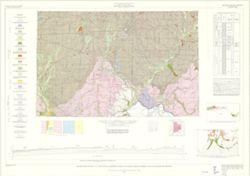
By Henry H. Gray, Jane L. Forsyth, Allan F. Schneider, and Ansel M. Gooding. Transverse Mercator projection. "Base map modified from Army Map Service, M...
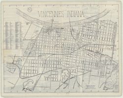
Includes index to streets and "Explanations for street name prefixing." Shows railroads, roads, churches, schools, fire houses, other public buildi...
Call Number:
G4094.E9 1929 .E3
Caption:
Imprint: Philadelphia, Penna. : E.E. Brownell, [1929]
Physical Description:
Dimensions: 45 x 68 cm, on sheet 56 x 86 cm and Scale: 1:18,000
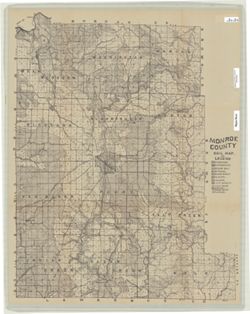
Topical Subject: Geology, Economic, Topical Subject: Mines and mineral resources, Geographic Subject: Sullivan County (Ind.), and Topical Subject: IGS Annual...
Creator:
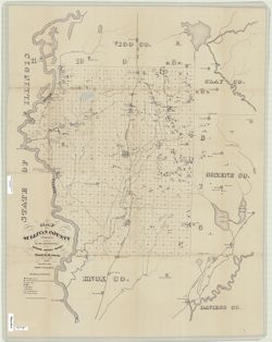
Levette, G. M. (Gilbert M.), Collett, John, 1828-1899, and Cox, E. T. (Edward Travers), 1821-1907
Drawn by G.M. Levette, for the second annual report of Prof. E.T. Cox, state geologist , geology by John Collett. "Braden & Burford, Lith., Indianap...
Call Number:
G4093.S8H1 1870 .L4
Caption:
Imprint: Indianapolis, Ind. : Geological Survey of Indiana, [1871]
Physical Description:
Scale: Approximately 1:85,000 and Dimensions: on sheet 82 x 64 cm
Alternate Identifier:
Title Control Number: a18283359 and Alternate ID: 390721IP
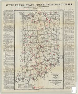
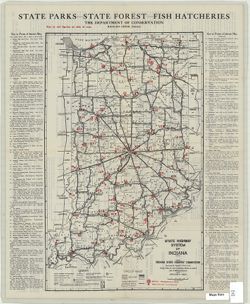
Topical Subject: Parks, Topical Subject: Roads, and Geographic Subject: Indiana
Creator:
Indiana. Department of Conservation
Publisher:
Indiana. State Highway Commission (1919-1953)
Date Created:
1924
Identifier:
VAC3073-M-01238
Genre:
Tourist maps
Geographic Location:
Coordinates: W0880500 W0844700 N0414500 N0374600
Related URL:
Catalog URL: https://iucat.iu.edu/catalog/4040824
Abstract:
Compiled by Chas. G. Sauers. Map title: Map of Indiana showing points of interest and state highways. "Map furnished by Indiana State Highway Commission...
Call Number:
G4091 .E635 1924 .I6
Caption:
Imprint: [Indianapolis] : The Department of Conservation, 1924
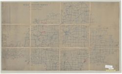
Geographic Subject: Lawrence County (Ind.), Geographic Subject: Lost River Watershed (Ind.), Topical Subject: Drainage, Geographic Subject: Lost River (Ind. ...
Creator:
Malott, Clyde A.
Publisher:
[publisher not identified]
Date Created:
1927
Identifier:
VAC3073-M-01239
Genre:
Manuscript maps and Thematic maps
Geographic Location:
Coordinates: W0864059 W0861220 N0384445 N0383053
Related URL:
Catalog URL: https://iucat.iu.edu/catalog/7745828
Abstract:
Pen, colored ink and colored pencils on drafting cloth. Includes table of drainage areas.
Call Number:
G4092.L8C315 1927 .M35
Caption:
Imprint: [Place of publication not identified] : [publisher not identified], 1927.
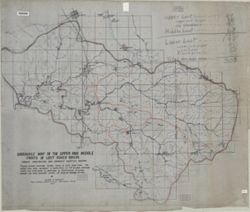
Geographic Subject: Indiana, Topical Subject: Parks, and Topical Subject: Roads
Creator:
Indiana. Department of Conservation
Publisher:
Indiana. State Highway Commission (1919-1953)
Date Created:
1925
Identifier:
VAC3073-M-01237
Genre:
Tourist maps
Geographic Location:
Coordinates: W0880500 W0844700 N0414500 N0374600
Related URL:
Catalog URL: https://iucat.iu.edu/catalog/1204523
Abstract:
Map title: Map of Indiana showing points of interest and state highways. "Map furnished by Indiana State Highway Commission, R.F. Pickens, del." On...
Call Number:
G4091.E635 1925 .I6
Caption:
Imprint: [Indianapolis] : The Department of Conservation, [approximately 1925]
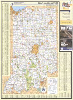
Panel title: Indiana, 2011/2012, taking major moves forward. Includes indexes, note, and color illustrations. Text, indexed map of "Downtown Indianapoli...
Call Number:
G1403 .S7 2011-2012
Caption:
Imprint: [Indianapolis] : Indiana Department of Transportation, [2011]
Physical Description:
Dimensions: 94 x 59 cm and Scale: Approximately 1:550,000