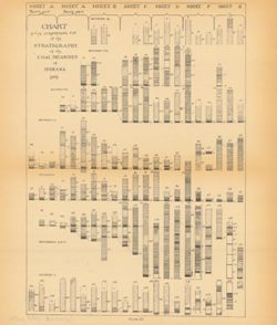
Includes stratigraphic columns, correlation lines, and depth measurements. Plate IX. Columnar sections included in this diagram are also shown accompanying a...
Call Number:
G4091.H9 1898 .C43
Caption:
Imprint: [Indianapolis] : [Indiana Department of Geology and Natural Resources], [1899]
Physical Description:
Dimensions: 27 x 23 cm and Scale: Scale not given.
Alternate Identifier:
Title Control Number: a18276213 and Alternate ID: 390726IP
Geographic Subject: Indiana, Topical Subject: Gas fields, Topical Subject: Oil fields, and Topical Subject: Natural gas--Storage
Creator:
Carpenter, G. L. (Gerald Leon), 1924-2012
Publisher:
Indiana. Department of Natural Resources
Date Created:
1976
Identifier:
VAC3073-M-00117
Genre:
Thematic maps
Geographic Location:
Coordinates: W0880000 W0850000 N0414500 N0380000
Related URL:
Catalog URL: https://iucat.iu.edu/catalog/5363901
Abstract:
"Base modified from U.S. Geological Survey base map of Indiana, 1950". "Compiled from Indiana Geological Survey Petroleum Exploration Maps of ...
Call Number:
G4091 .H8 1976 .C3
Caption:
Imprint: 1) [Indianapolis, Indiana] : [State of Indiana, Department of Natural Resources], 1976 2) Bloomington, Indiana : Publications Section, Indiana Ge...
Geographic Subject: Indiana, Topical Subject: Coal mines and mining, and Topical Subject: Coal
Creator:
Coal Trade Association of Indiana
Publisher:
Coal Trade Association of Indiana
Date Created:
1947
Identifier:
VAC3073-M-00116
Genre:
Thematic maps and Mine maps
Geographic Location:
Coordinates: W0880500 W0844700 N0414500 N0374600
Related URL:
Catalog URL: https://iucat.iu.edu/catalog/5277927
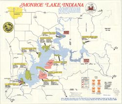
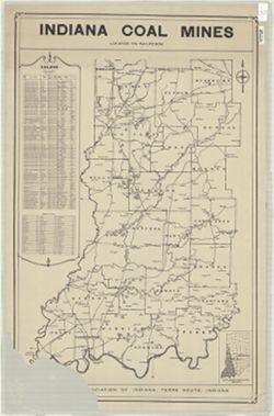
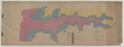
Abstract:
Shows southwestern Indiana from Newport in the north to the Ohio River on the south and from the Wabash River on the west to Morgantown on the east. Includes...
Call Number:
G4091.H9 1947 .C63
Caption:
Imprint: Terre Haute, Ind. : The Association, [1947?]
Physical Description:
Dimensions: 84 x 59 cm and Scale: Scale not given.
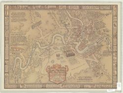
Geographic Subject: Fort Wayne (Ind.) and Topical Subject: History
Creator:
Brainard, Noble E.
Publisher:
News-Sentinel
Date Created:
1989
Identifier:
VAC3073-M-00115
Genre:
Thematic maps and Pictorial maps
Geographic Location:
Coordinates: W0851811 W0845955 N0411159 N0405755
Related URL:
Catalog URL: https://iucat.iu.edu/catalog/4965612
Abstract:
"The area included on the map is about 2 1/2 miles from east to west & 1 7/8 miles north to south." Includes illustrations and text on the map ...
Geographic Subject: Clifty Falls State Park (Ind.)
Publisher:
Indiana. Department of Conservation
Date Created:
1922
Identifier:
VAC3073-M-00114
Genre:
Topographic maps
Geographic Location:
Coordinates: W0852521 W0852511 N0384523 N0384513
Related URL:
Catalog URL: https://iucat.iu.edu/catalog/5325180
Abstract:
"Surveyed 1921-22 by The Department of Conservation, State of Indiana, Division of Engineering." Oriented with north toward the lower right. Black ...
Call Number:
G4092.C59 1922 .T67
Caption:
Imprint: [Indianapolis?] : [Indiana Dept. of Conservation?], [192?]
Physical Description:
Scale: Approximately 1:2,400 and Dimensions: 70 x 190 cm
Relief shown by profile. Includes index map showing locations of coal fields in around Washington in Daviess County, Indiana, 25 stratigraphic columns, corre...
Call Number:
G4093.D2H9 1898 .C63
Caption:
Imprint: [Indianapolis] : [Indiana Department of Geology and Natural Resources], [1899]
Physical Description:
Dimensions: 23 x 26 cm and Scale: Approximately 1:63,360
Alternate Identifier:
Alternate ID: 390726IP and Title Control Number: a18214666
Title derived by cataloger from accompanying text. Shows administrative regions adopted by the Indiana Vocational Technical College (IVTC), including those w...
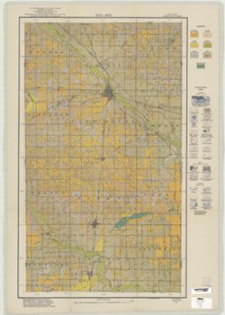
Topical Subject: Soils and Geographic Subject: Adams County (Ind.)
Creator:
Jones, Grove B., 1877-
Publisher:
United States. Bureau of Soils
Date Created:
1921
Identifier:
VAC3073-M-00111
Genre:
Thematic maps
Geographic Location:
Coordinates: W0850400 W0844700 N0405700 N0403400
Related URL:
Catalog URL: https://iucat.iu.edu/catalog/2863406
Abstract:
Shows soil types classification by colors and symbols. Relief shown by contours and hachures. Soils surveyed by Grove B. Jones, Mark Baldwin, S.C. Jones, Tho...
Call Number:
G4093 .A2J3 1921 .J6
Caption:
Imprint: [Washington, D.C.?] : The Bureau, [1921?]

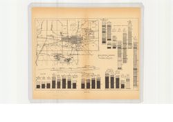
![[Indiana Vocational Technical College regional divisions map]](https://iiif.uits.iu.edu/iiif/2/9306v223c%2Ffiles%2F8a6eb2dc-5701-44ea-bf10-63f6864b672d/full/250,/0/default.jpg)
![Floyd County [Indiana] land use map : preliminary](https://iiif.uits.iu.edu/iiif/2/r207vr80n%2Ffiles%2Fba1ce671-118c-499c-8c40-0c3612b65e19/full/250,/0/default.jpg)