
Search Constraints
You searched for:
Publisher
Geological Survey (U.S.)
Remove constraint Publisher: Geological Survey (U.S.)
Subject
Geographic Subject: Knox County (Ind.)
Remove constraint Subject: Geographic Subject: Knox County (Ind.)
1 - 23 of 23
Search Results
-
![Indiana-Illinois, Vincennes quadrangle : topography [1944 printing without vegetation]](https://iiif.uits.iu.edu/iiif/2/5425mf004%2Ffiles%2Fed25173c-f2ac-49e5-986c-99cf4220f9c3/full/250,/0/default.jpg)
- Subject:
- Geographic Subject: Gibson County (Ind.), Geographic Subject: Wabash County (Ill.), Geographic Subject: Lawrence County (Ill.), and Geographic Subject: Knox ...
- Creator:
- Marshall, R. B. (Robert Bradford), 1867-1949, Geological Survey (U.S.), Tweedy, Frank, 1854-1937, United States. Army. Corps of Engineers, Illinois State Geo...
- Publisher:
- Geological Survey (U.S.)
- Date Created:
- 1944
- Identifier:
- VAC3073-M-01508
- Genre:
- Topographic maps, 15 minute topographic maps, and Quadrangle maps
- Geographic Location:
- Coordinates: W0874500 W0873000 N0384500 N0383000
- Related URL:
- Catalog URL: https://iucat.iu.edu/catalog/18415517
- Abstract:
- R.B. Marshall, chief geographer , W.H. Herron, geographer in charge , topography by Frank Tweedy, C.L. Sadler, Chas. Hartmann, Jr., L.L. Lee, W.S. Gehres, an...
- Call Number:
- G4090 s62 .G4 Vincennes 1944
- Caption:
- Imprint: [Washington, D.C.] : U.S. Geological Survey, 1944.
- Physical Description:
- Scale: 1:62,500 and Dimensions: 45 x 42 cm or smaller
- Alternate Identifier:
- Title Control Number: a18415517
- Persistent URL:
- https://purl.dlib.indiana.edu/iudl/images/VAC3073/VAC3073-M-01508
- Provenance:
- Part of Geological Survey (U.S.). Indiana 1:62,500.
-
![Princeton quadrangle, Indiana-Illinois : 15 minute series (topographic) [1965 reprint with vegetation]](https://iiif.uits.iu.edu/iiif/2/7m01cp47j%2Ffiles%2Fdc826735-24b7-4c3f-9d9b-87ad67efd7e8/full/250,/0/default.jpg)
- Subject:
- Geographic Subject: Gibson County (Ind.), Geographic Subject: Knox County (Ind.), Geographic Subject: Wabash County (Ill.), and Topical Subject: Vegetation m...
- Creator:
- Geological Survey (U.S.), United States. Army Map Service, and Illinois State Geological Survey
- Publisher:
- Geological Survey (U.S.)
- Date Created:
- 1965
- Identifier:
- VAC3073-M-01504
- Genre:
- Topographic maps, 15 minute topographic maps, and Quadrangle maps
- Geographic Location:
- Coordinates: W0874500 W0873000 N0383000 N0381500
- Related URL:
- Catalog URL: https://iucat.iu.edu/catalog/18413928
- Abstract:
- Mapped, edited and published by the Geological Survey , Illinois area mapped in cooperation with State of Illinois Geological Survey. Filing title: Princeton...
- Call Number:
- G4090 s62 .G4 Princeton 1959 V
- Caption:
- Imprint: Washington, D.C. : Interior--U.S. Geological Survey, 1965
- Physical Description:
- Scale: 1:62,500 and Dimensions: 45 x 42 cm or smaller
- Alternate Identifier:
- Title Control Number: a18413928
- Persistent URL:
- https://purl.dlib.indiana.edu/iudl/images/VAC3073/VAC3073-M-01504
- Provenance:
- Part of Geological Survey (U.S.). Indiana 1:62,500.
-
![Princeton quadrangle, Indiana-Illinois : 15 minute series (topographic) [1965 printing without vegetation]](https://iiif.uits.iu.edu/iiif/2/70796d47m%2Ffiles%2Fedc5c6d4-9f41-4b7c-9447-a370bfe906e0/full/250,/0/default.jpg)
- Subject:
- Geographic Subject: Knox County (Ind.), Geographic Subject: Gibson County (Ind.), and Geographic Subject: Wabash County (Ill.)
- Creator:
- Illinois State Geological Survey, United States. Army Map Service, and Geological Survey (U.S.)
- Publisher:
- Geological Survey (U.S.)
- Date Created:
- 1965
- Identifier:
- VAC3073-M-01503
- Genre:
- Quadrangle maps, 15 minute topographic maps, and Topographic maps
- Geographic Location:
- Coordinates: W0874500 W0873000 N0383000 N0381500
- Related URL:
- Catalog URL: https://iucat.iu.edu/catalog/18413928
- Abstract:
- Mapped, edited and published by the Geological Survey , Illinois area mapped in cooperation with State of Illinois Geological Survey. Filing title: Princeton...
- Call Number:
- G4090 s62 .G4 Princeton 1959
- Caption:
- Imprint: Washington, D.C. : Interior--U.S. Geological Survey, 1964.
- Physical Description:
- Dimensions: 45 x 42 cm or smaller and Scale: 1:62,500
- Alternate Identifier:
- Title Control Number: a18413928
- Persistent URL:
- https://purl.dlib.indiana.edu/iudl/images/VAC3073/VAC3073-M-01503
- Provenance:
- Part of Geological Survey (U.S.). Indiana 1:62,500.
-
![Indiana-Illinois Patoka quadrangle [1921 reprint]](https://iiif.uits.iu.edu/iiif/2/t435hg288%2Ffiles%2F74c3c556-9b7b-4cea-8524-77cc4573da67/full/250,/0/default.jpg)
- Subject:
- Geographic Subject: Posey County (Ind.), Geographic Subject: Gibson County (Ind.), Geographic Subject: White County (Ill.), Geographic Subject: Vanderburgh C...
- Creator:
- Hawkins, Geo. T. (George T.), Geological Survey (U.S.), Renshawe, John H., and Goodlove, C. W.
- Publisher:
- Geological Survey (U.S.)
- Date Created:
- 1921
- Identifier:
- VAC3073-M-01419
- Genre:
- 30 minute topographic maps, Topographic maps, and Quadrangle maps
- Geographic Location:
- Coordinates: W0880000 W0873000 N0383000 N0380000
- Related URL:
- Catalog URL: https://iucat.iu.edu/catalog/18416043
- Abstract:
- Jno. H. Renshawe, geographer in charge , control by Geo. T. Hawkins , topography by Chas. W. Goodlove , engraved June 1903 by U.S.G.S. Relief shown by contou...
- Call Number:
- G4090 s125 .G4 Patoka 1903 rep1921
- Caption:
- Imprint: [Washington, D.C.] : U.S. Geological Survey, 1921
- Physical Description:
- Dimensions: 45 x 36 cm and Scale: 1:125,000
- Alternate Identifier:
- Title Control Number: a18416043
- Persistent URL:
- https://purl.dlib.indiana.edu/iudl/images/VAC3073/VAC3073-M-01419
- Provenance:
- Part of Geological Survey (U.S.). Indiana 1:125,000.
-
![Indiana-Illinois Patoka quadrangle [1903 print]](https://iiif.uits.iu.edu/iiif/2/697004346%2Ffiles%2Fa8ce9ba2-6345-47f5-8aa5-e6adddaad8fd/full/250,/0/default.jpg)
- Subject:
- Geographic Subject: White County (Ill.), Geographic Subject: Edwards County (Ill.), Geographic Subject: Knox County (Ind.), Geographic Subject: Posey County ...
- Creator:
- Goodlove, C. W., Hawkins, Geo. T. (George T.), Geological Survey (U.S.), and Renshawe, John H.
- Publisher:
- Geological Survey (U.S.)
- Date Created:
- 1903
- Identifier:
- VAC3073-M-01418
- Genre:
- 30 minute topographic maps, Quadrangle maps, and Topographic maps
- Geographic Location:
- Coordinates: W0880000 W0873000 N0383000 N0380000
- Related URL:
- Catalog URL: https://iucat.iu.edu/catalog/18416043
- Abstract:
- Jno. H. Renshawe, geographer in charge , control by Geo. T. Hawkins , topography by Chas. W. Goodlove , engraved June 1903 by U.S.G.S. Relief shown by contou...
- Call Number:
- G4090 s125 .G4 Patoka 1903
- Caption:
- Imprint: [Washington, D.C.] : U.S. Geological Survey, [1903]
- Physical Description:
- Dimensions: 45 x 36 cm and Scale: 1:125,000
- Alternate Identifier:
- Title Control Number: a18416043
- Persistent URL:
- https://purl.dlib.indiana.edu/iudl/images/VAC3073/VAC3073-M-01418
- Provenance:
- Part of Geological Survey (U.S.). Indiana 1:125,000.
-
![Indiana-Illinois, Vincennes quadrangle : topography [1958 reprint with vegetation]](https://iiif.uits.iu.edu/iiif/2/bv73d371v%2Ffiles%2Fd8eeacfe-4380-4ba5-814d-cbf9ec40a053/full/250,/0/default.jpg)
- Subject:
- Geographic Subject: Wabash County (Ill.), Topical Subject: Vegetation mapping, Geographic Subject: Lawrence County (Ill.), Geographic Subject: Gibson County ...
- Creator:
- Geological Survey (U.S.)
- Publisher:
- Geological Survey (U.S.)
- Date Created:
- 1958
- Identifier:
- VAC3073-M-01412
- Genre:
- Quadrangle maps, Topographic maps, and 15 minute topographic maps
- Geographic Location:
- Coordinates: W0874500 W0873000 N0384500 N0383000
- Related URL:
- Catalog URL: https://iucat.iu.edu/catalog/18415517
- Abstract:
- R.B. Marshall, chief geographer , W.H. Herron, geographer in charge , topography by Frank Tweedy, C.L. Sadler, Chas. Hartmann, Jr., L.L. Lee, W.S. Gehres, an...
- Call Number:
- G4090 s62 .G4 Vincennes 1944 rep1958 V
- Caption:
- Imprint: [Washington, D.C.] : U.S. Geological Survey, 1958
- Physical Description:
- Dimensions: 45 x 42 cm or smaller and Scale: 1:62,500
- Alternate Identifier:
- Title Control Number: a18415517
- Persistent URL:
- https://purl.dlib.indiana.edu/iudl/images/VAC3073/VAC3073-M-01412
- Provenance:
- Part of Geological Survey (U.S.). Indiana 1:62,500.
-
![Indiana, 15 minute series (topographic), Vincennes quadrangle. [1915 printing with vegetation]](https://iiif.uits.iu.edu/iiif/2/d791tm29s%2Ffiles%2F3ba9ccbe-8be1-48ce-9aac-c0c3b1eb0e6b/full/250,/0/default.jpg)
- Subject:
- Geographic Subject: Lawrence County (Ill.), Topical Subject: Vegetation mapping, Geographic Subject: Knox County (Ind.), Geographic Subject: Gibson County (I...
- Creator:
- Tweedy, Frank, 1854-1937, Geological Survey (U.S.), Marshall, R. B. (Robert Bradford), 1867-1949, United States. Army. Corps of Engineers, Herron, W. H. (Wil...
- Publisher:
- Geological Survey (U.S.)
- Date Created:
- 1915
- Identifier:
- VAC3073-M-01411
- Genre:
- 15 minute topographic maps, Topographic maps, and Quadrangle maps
- Geographic Location:
- Coordinates: W0874500 W0873000 N0384500 N0383000
- Related URL:
- Catalog URL: https://iucat.iu.edu/catalog/18415508
- Abstract:
- R.B. Marshall, chief geographer , W.H. Herron, geographer in charge , topography by Frank Tweedy, C.L. Sadler, Chas. Hartmann, Jr., L.L. Lee, W.S. Gehres, an...
- Call Number:
- G4090 s62 .G4 Vincennes 1915
- Caption:
- Imprint: [Washington, D.C.] : U.S. Geological Survey, [1915]
- Physical Description:
- Dimensions: 45 x 42 cm or smaller and Scale: 1:62,500
- Alternate Identifier:
- Title Control Number: a18415508
- Persistent URL:
- https://purl.dlib.indiana.edu/iudl/images/VAC3073/VAC3073-M-01411
- Provenance:
- Part of Geological Survey (U.S.). Indiana 1:62,500.
-
![Indiana-Illinois, Vincennes quadrangle : topography [1946 reprint with corrections and without vegetation]](https://iiif.uits.iu.edu/iiif/2/n009x521b%2Ffiles%2Fda21d6eb-ada6-4f1f-8c3c-8022f31eb1a9/full/250,/0/default.jpg)
- Subject:
- Geographic Subject: Lawrence County (Ill.), Geographic Subject: Knox County (Ind.), Geographic Subject: Gibson County (Ind.), and Geographic Subject: Wabash ...
- Creator:
- Geological Survey (U.S.), U.S. Coast and Geodetic Survey, Tweedy, Frank, 1854-1937, Illinois State Geological Survey, Marshall, R. B. (Robert Bradford), 1867...
- Publisher:
- Geological Survey (U.S.)
- Date Created:
- 1946
- Identifier:
- VAC3073-M-01410
- Genre:
- 15 minute topographic maps, Quadrangle maps, and Topographic maps
- Geographic Location:
- Coordinates: W0874500 W0873000 N0384500 N0383000
- Related URL:
- Catalog URL: https://iucat.iu.edu/catalog/18415510
- Abstract:
- R.B. Marshall, chief geographer , W.H. Herron, geographer in charge , topography by Frank Tweedy, C.L. Sadler, Chas. Hartmann, Jr., L.L. Lee, W.S. Gehres, an...
- Call Number:
- G4090 s62 .G4 Vincennes 1915 rep1946
- Caption:
- Imprint: [Washington, D.C.] : U.S. Geological Survey, 1946
- Physical Description:
- Scale: 1:62,500 and Dimensions: 45 x 42 cm or smaller
- Alternate Identifier:
- Title Control Number: a18415510
- Persistent URL:
- https://purl.dlib.indiana.edu/iudl/images/VAC3073/VAC3073-M-01410
- Provenance:
- Part of Geological Survey (U.S.). Indiana 1:62,500.
-
![Indiana, 15 minute series (topographic), Vincennes quadrangle. [1934 reprint without vegetation]](https://iiif.uits.iu.edu/iiif/2/h702rb42n%2Ffiles%2Ff1e13118-9dbf-4ee1-a0ac-56cd2eb3a880/full/250,/0/default.jpg)
- Subject:
- Geographic Subject: Gibson County (Ind.), Geographic Subject: Knox County (Ind.), Geographic Subject: Lawrence County (Ill.), and Geographic Subject: Wabash ...
- Creator:
- Tweedy, Frank, 1854-1937, U.S. Coast and Geodetic Survey, Herron, W. H. (William Harrison), 1865-, United States. Army. Corps of Engineers, Geological Survey...
- Publisher:
- Geological Survey (U.S.)
- Date Created:
- 1934
- Identifier:
- VAC3073-M-01409
- Genre:
- Topographic maps, Quadrangle maps, and 15 minute topographic maps
- Geographic Location:
- Coordinates: W0874500 W0873000 N0384500 N0383000
- Related URL:
- Catalog URL: https://iucat.iu.edu/catalog/18415508
- Abstract:
- R.B. Marshall, chief geographer , W.H. Herron, geographer in charge , topography by Frank Tweedy, C.L. Sadler, Chas. Hartmann, Jr., L.L. Lee, W.S. Gehres, an...
- Call Number:
- G4090 s62 .G4 Vincennes 1915 rep1934
- Caption:
- Imprint: [Washington, D.C.] : U.S. Geological Survey, 1934
- Physical Description:
- Scale: 1:62,500 and Dimensions: 45 x 42 cm or smaller
- Alternate Identifier:
- Title Control Number: a18415508
- Persistent URL:
- https://purl.dlib.indiana.edu/iudl/images/VAC3073/VAC3073-M-01409
- Provenance:
- Part of Geological Survey (U.S.). Indiana 1:62,500.
-
![Princeton quadrangle, Indiana-Illinois : 15 minute series (topographic) [1965 reprint with vegetation]](https://iiif.uits.iu.edu/iiif/2/sx61fr138%2Ffiles%2F603798b1-0337-482a-9bb7-934a41ad4b2b/full/250,/0/default.jpg)
- Subject:
- Geographic Subject: Knox County (Ind.), Geographic Subject: Wabash County (Ill.), Topical Subject: Vegetation mapping, and Geographic Subject: Gibson County ...
- Creator:
- Geological Survey (U.S.), Illinois State Geological Survey, and United States. Army Map Service
- Publisher:
- Geological Survey (U.S.)
- Date Created:
- 1965
- Identifier:
- VAC3073-M-01388
- Genre:
- 15 minute topographic maps, Quadrangle maps, and Topographic maps
- Geographic Location:
- Coordinates: W0874500 W0873000 N0383000 N0381500
- Related URL:
- Catalog URL: https://iucat.iu.edu/catalog/18413928
- Abstract:
- Mapped, edited and published by the Geological Survey , Illinois area mapped in cooperation with State of Illinois Geological Survey. Filing title: Princeton...
- Call Number:
- G4090 s62 .G4 Princeton 1959 rep1965 V
- Caption:
- Imprint: Washington, D.C. : Interior--U.S. Geological Survey, 1965.
- Physical Description:
- Dimensions: 45 x 42 cm or smaller and Scale: 1:62,500
- Alternate Identifier:
- Title Control Number: a18413928
- Persistent URL:
- https://purl.dlib.indiana.edu/iudl/images/VAC3073/VAC3073-M-01388
- Provenance:
- Part of Geological Survey (U.S.). Indiana 1:62,500.
-
![Princeton quadrangle, Indiana-Illinois : 15 minute series (topographic) [1964 printing with vegetation]](https://iiif.uits.iu.edu/iiif/2/m900px89p%2Ffiles%2Fe957c77d-db8c-42d6-aef0-05abd0d3301b/full/250,/0/default.jpg)
- Subject:
- Geographic Subject: Gibson County (Ind.), Topical Subject: Vegetation mapping, Geographic Subject: Wabash County (Ill.), and Geographic Subject: Knox County ...
- Creator:
- Geological Survey (U.S.), United States. Army Map Service, and Illinois State Geological Survey
- Publisher:
- Geological Survey (U.S.)
- Date Created:
- 1964
- Identifier:
- VAC3073-M-01387
- Genre:
- Quadrangle maps, 15 minute topographic maps, and Topographic maps
- Geographic Location:
- Coordinates: W0874500 W0873000 N0383000 N0381500
- Related URL:
- Catalog URL: https://iucat.iu.edu/catalog/18413928
- Abstract:
- Mapped, edited and published by the Geological Survey , Illinois area mapped in cooperation with State of Illinois Geological Survey. Filing title: Princeton...
- Call Number:
- G4090 s62 .G4 1959 rep1964 V
- Caption:
- Imprint: Washington, D.C. : Interior--U.S. Geological Survey, 1964
- Physical Description:
- Dimensions: 45 x 42 cm or smaller and Scale: 1:62,500
- Alternate Identifier:
- Title Control Number: a18413928
- Persistent URL:
- https://purl.dlib.indiana.edu/iudl/images/VAC3073/VAC3073-M-01387
- Provenance:
- Part of Geological Survey (U.S.). Indiana 1:62,500.
-
![Princeton quadrangle, Indiana-Illinois : 15 minute series (topographic) [1964 printing with vegetation]](https://iiif.uits.iu.edu/iiif/2/ng452m35w%2Ffiles%2F49af6c65-fc22-44ea-8486-c7923f5afb8b/full/250,/0/default.jpg)
- Subject:
- Geographic Subject: Knox County (Ind.), Geographic Subject: Gibson County (Ind.), Geographic Subject: Wabash County (Ill.), and Topical Subject: Vegetation m...
- Creator:
- Illinois State Geological Survey, Geological Survey (U.S.), and United States. Army Map Service
- Publisher:
- Geological Survey (U.S.)
- Date Created:
- 1964
- Identifier:
- VAC3073-M-01386
- Genre:
- 15 minute topographic maps, Topographic maps, and Quadrangle maps
- Geographic Location:
- Coordinates: W0874500 W0873000 N0383000 N0381500
- Related URL:
- Catalog URL: https://iucat.iu.edu/catalog/18413928
- Abstract:
- Mapped, edited and published by the Geological Survey , Illinois area mapped in cooperation with State of Illinois Geological Survey. Filing title: Princeton...
- Call Number:
- G4090 s62 .G4 Princeton 1959 rep1964
- Caption:
- Imprint: Washington, D.C. : Interior--U.S. Geological Survey, 1964
- Physical Description:
- Scale: 1:62,500 and Dimensions: 45 x 42 cm or smaller
- Alternate Identifier:
- Title Control Number: a18413928
- Persistent URL:
- https://purl.dlib.indiana.edu/iudl/images/VAC3073/VAC3073-M-01386
- Provenance:
- Part of Geological Survey (U.S.). Indiana 1:62,500.
-
![Indiana-Illinois Princeton quadrangle [1942 reprint with corrections]](https://iiif.uits.iu.edu/iiif/2/5425md989%2Ffiles%2Fb50408af-597e-49b1-b839-d9b52b097540/full/250,/0/default.jpg)
- Subject:
- Geographic Subject: Gibson County (Ind.) and Geographic Subject: Knox County (Ind.)
- Creator:
- Geological Survey (U.S.), Goodlove, C. W., Renshawe, John H., and Hawkins, Geo. T. (George T.)
- Publisher:
- Geological Survey (U.S.)
- Date Created:
- 1942
- Identifier:
- VAC3073-M-01385
- Genre:
- Quadrangle maps, Topographic maps, and 15 minute topographic maps
- Geographic Location:
- Coordinates: W0874500 W0873000 N0383000 N0381500
- Related URL:
- Catalog URL: https://iucat.iu.edu/catalog/18413585
- Abstract:
- Jno. H. Renshawe, geographer in charge , control by Geo. T. Hawkins , topography by Chas. W. Goodlove. Filing title: Princeton, Ind.-Ill. Edition of 1903, re...
- Call Number:
- Part of Geological Survey (U.S.). Indiana 1:62,500.
- Caption:
- Imprint: [Washington, D.C.] : U.S. Geological Survey, 1942.
- Physical Description:
- Dimensions: 45 x 42 cm or smaller and Scale: 1:62,500
- Alternate Identifier:
- Title Control Number: a18413585
- Persistent URL:
- https://purl.dlib.indiana.edu/iudl/images/VAC3073/VAC3073-M-01385
- Provenance:
- Part of Geological Survey (U.S.). Indiana 1:62,500.
-
![Indiana-Illinois Princeton quadrangle [1922 reprint without vegetation]](https://iiif.uits.iu.edu/iiif/2/0r968719t%2Ffiles%2F75ec17c9-3877-4a76-8f1a-579970db193c/full/250,/0/default.jpg)
- Subject:
- Geographic Subject: Knox County (Ind.), Geographic Subject: Wabash County (Ill.), and Geographic Subject: Gibson County (Ind.)
- Creator:
- Goodlove, C. W., Geological Survey (U.S.), Renshawe, John H., and Hawkins, Geo. T. (George T.)
- Publisher:
- Geological Survey (U.S.)
- Date Created:
- 1922
- Identifier:
- VAC3073-M-01384
- Genre:
- 15 minute topographic maps, Topographic maps, and Quadrangle maps
- Geographic Location:
- Coordinates: W0874500 W0873000 N0383000 N0381500
- Related URL:
- Catalog URL: https://iucat.iu.edu/catalog/18413584
- Abstract:
- Jno. H. Renshawe, geographer in charge , control by Geo. T. Hawkins , topography by Chas. W. Goodlove. Filing title: Princeton, Ind.-Ill. Edition of 1903. Re...
- Call Number:
- G4090 s62 .G4 Princeton 1903 rep1922
- Caption:
- Imprint: Washington, D.C. : U.S. Geological Survey, 1922
- Physical Description:
- Scale: 1:62,500 and Dimensions: 45 x 42 cm or smaller
- Alternate Identifier:
- Title Control Number: a18413584
- Persistent URL:
- https://purl.dlib.indiana.edu/iudl/images/VAC3073/VAC3073-M-01384
- Provenance:
- Part of Geological Survey (U.S.). Indiana 1:62,500.
-
![Indiana-Illinois Princeton quadrangle [1918 reprint without vegetation]](https://iiif.uits.iu.edu/iiif/2/k356b654d%2Ffiles%2Fb7ecfd4f-f49f-4665-bea2-c519898beb43/full/250,/0/default.jpg)
- Subject:
- Geographic Subject: Gibson County (Ind.), Geographic Subject: Knox County (Ind.), and Geographic Subject: Wabash County (Ill.)
- Creator:
- Hawkins, Geo. T. (George T.), Geological Survey (U.S.), Renshawe, John H., and Goodlove, C. W.
- Publisher:
- Geological Survey (U.S.)
- Date Created:
- 1918
- Identifier:
- VAC3073-M-01383
- Genre:
- 15 minute topographic maps, Topographic maps, and Quadrangle maps
- Geographic Location:
- Coordinates: W0874500 W0873000 N0383000 N0381500
- Related URL:
- Catalog URL: https://iucat.iu.edu/catalog/18413584
- Abstract:
- Jno. H. Renshawe, geographer in charge , control by Geo. T. Hawkins , topography by Chas. W. Goodlove. Filing title: Princeton, Ind.-Ill. Edition of 1903. Re...
- Call Number:
- G4090 s62 .G4 Princeton 1903 rep1918
- Caption:
- Imprint: Washington, D.C. : U.S. Geological Survey, 1918.
- Physical Description:
- Dimensions: 45 x 42 cm or smaller and Scale: 1:62,500
- Alternate Identifier:
- Title Control Number: a18413584
- Persistent URL:
- https://purl.dlib.indiana.edu/iudl/images/VAC3073/VAC3073-M-01383
- Provenance:
- Part of Geological Survey (U.S.). Indiana 1:62,500.
-
![Indiana-Illinois Princeton quadrangle [1949 printing with minor corrections]](https://iiif.uits.iu.edu/iiif/2/2801qk457%2Ffiles%2Fcc6a6a50-c066-4d88-b5e1-b12fb8789f26/full/250,/0/default.jpg)
- Subject:
- Geographic Subject: Gibson County (Ind.), Geographic Subject: Knox County (Ind.), and Geographic Subject: Wabash County (Ill.)
- Creator:
- Geological Survey (U.S.), Goodlove, C. W., Renshawe, John H., and Hawkins, Geo. T. (George T.)
- Publisher:
- Geological Survey (U.S.)
- Date Created:
- 1949
- Identifier:
- VAC3073-M-01381
- Genre:
- 15 minute topographic maps, Quadrangle maps, and Topographic maps
- Geographic Location:
- Coordinates: W0874500 W0873000 N0383000 N0381500
- Related URL:
- Catalog URL: https://iucat.iu.edu/catalog/18413586
- Abstract:
- Jno. H. Renshawe, geographer in charge , control by Geo. T. Hawkins , topography by Chas. W. Goodlove. Filing title: Princeton, Ind.-Ill. [Edition of] 1901, ...
- Call Number:
- G4090 s62 .G4 Princeton 1901 MC1949
- Caption:
- Imprint: Washington, D.C. : Interior--Geological Survey, 1949.
- Physical Description:
- Dimensions: 45 x 42 cm or smaller and Scale: 1:62,500
- Alternate Identifier:
- Title Control Number: a18413586
- Persistent URL:
- https://purl.dlib.indiana.edu/iudl/images/VAC3073/VAC3073-M-01381
- Provenance:
- Part of Geological Survey (U.S.). Indiana 1:62,500.
-
![Indiana-Illinois Princeton quadrangle [1954 reprint without vegetation]](https://iiif.uits.iu.edu/iiif/2/jw828f49z%2Ffiles%2F930dff42-24ed-494d-8f59-03710825468a/full/250,/0/default.jpg)
- Subject:
- Geographic Subject: Knox County (Ind.), Geographic Subject: Gibson County (Ind.), and Geographic Subject: Wabash County (Ill.)
- Creator:
- Renshawe, John H., Goodlove, C. W., Geological Survey (U.S.), and Hawkins, Geo. T. (George T.)
- Publisher:
- Geological Survey (U.S.)
- Date Created:
- 1954
- Identifier:
- VAC3073-M-01382
- Genre:
- Quadrangle maps, 15 minute topographic maps, and Topographic maps
- Geographic Location:
- Coordinates: W0874500 W0873000 N0383000 N0381500
- Related URL:
- Catalog URL: https://iucat.iu.edu/catalog/18413586
- Abstract:
- Jno. H. Renshawe, geographer in charge , control by Geo. T. Hawkins , topography by Chas. W. Goodlove. Filing title: Princeton, Ind.-Ill. [Edition of] 1901, ...
- Call Number:
- G4090 s62 .G4 Princeton 1903 rep1954
- Caption:
- Imprint: Washington, D.C. : Interior--Geological Survey, 1954
- Physical Description:
- Scale: 1:62,500 and Dimensions: 45 x 42 cm or smaller
- Alternate Identifier:
- Title Control Number: a18413586
- Persistent URL:
- https://purl.dlib.indiana.edu/iudl/images/VAC3073/VAC3073-M-01382
- Provenance:
- Part of Geological Survey (U.S.). Indiana 1:62,500.
-
![Illinois-Indiana Birds quadrangle : topography [1943 reprint]](https://iiif.uits.iu.edu/iiif/2/k643c5517%2Ffiles%2F919c9455-6809-440d-bdac-0eaf5779317c/full/250,/0/default.jpg)
- Subject:
- Geographic Subject: Crawford County (Ill.), Geographic Subject: Sullivan County (Ind.), and Geographic Subject: Knox County (Ind.)
- Creator:
- U.S. Coast and Geodetic Survey, United States. Army, Graff, Fred, Jr., Herron, W. H. (William Harrison), 1865-, Marshall, R. B. (Robert Bradford), 1867-1949,...
- Publisher:
- Geological Survey (U.S.)
- Date Created:
- 1943
- Identifier:
- VAC3073-M-01316
- Genre:
- Quadrangle maps, Topographic maps, and 15 minute topographic maps
- Geographic Location:
- Coordinates: W0874500 W0873000 N0390000 N0384500
- Related URL:
- Catalog URL: https://iucat.iu.edu/catalog/18408527
- Abstract:
- R.B. Marshall, Chief Geographer , W.H. Herron, Geographer in charge , topography by F. Graff, Jr. , control by Corps of Engineers U.S. Army, U.S. Coast and G...
- Call Number:
- G4090 s62 .G4 Birds 1917 R1943
- Caption:
- Imprint: [Urbana, Ill.] : Geological Survey Division, [1943] and Imprint: [Washington, D.C.] : U.S. Geological Survey
- Physical Description:
- Dimensions: 45 x 42 cm or smaller and Scale: 1:62,500
- Alternate Identifier:
- Title Control Number: a18408527
- Persistent URL:
- https://purl.dlib.indiana.edu/iudl/images/VAC3073/VAC3073-M-01316
- Provenance:
- Part of Geological Survey (U.S.). Indiana 1:62,500.
-
![Illinois-Indiana Birds quadrangle : topography [1958 reprint]](https://iiif.uits.iu.edu/iiif/2/vt151n461%2Ffiles%2F8d479352-343d-4029-a644-fe61b614fa55/full/250,/0/default.jpg)
- Subject:
- Geographic Subject: Sullivan County (Ind.), Geographic Subject: Crawford County (Ill.), and Geographic Subject: Knox County (Ind.)
- Creator:
- U.S. Coast and Geodetic Survey, Herron, W. H. (William Harrison), 1865-, Marshall, R. B. (Robert Bradford), 1867-1949, Graff, Fred, Jr., United States. Army,...
- Publisher:
- Geological Survey (U.S.)
- Date Created:
- 1958
- Identifier:
- VAC3073-M-01317
- Genre:
- Quadrangle maps, Topographic maps, and 15 minute topographic maps
- Geographic Location:
- Coordinates: W0874500 W0873000 N0390000 N0384500
- Related URL:
- Catalog URL: https://iucat.iu.edu/catalog/18408528
- Abstract:
- R.B. Marshall, Chief Geographer , W.H. Herron, Geographer in charge , topography by F. Graff, Jr. , control by Corps of Engineers U.S. Army, U.S. Coast and G...
- Call Number:
- G4090 s62 .G4 Birds 1942 rep1958
- Caption:
- Imprint: Washington, D.C. : Interior--Geological Survey, 1958. Washington, D.C. : for sale by U.S. Geological Survey and Imprint: Urbana, Illinois : State Ge...
- Physical Description:
- Scale: 1:62,500 and Dimensions: 45 x 42 cm or smaller
- Alternate Identifier:
- Title Control Number: a18408528
- Persistent URL:
- https://purl.dlib.indiana.edu/iudl/images/VAC3073/VAC3073-M-01317
- Provenance:
- Part of Geological Survey (U.S.). Indiana 1:62,500.
-
![Indiana-Illinois Princeton quadrangle [1942 print with corrections]](https://iiif.uits.iu.edu/iiif/2/9c67xs27g%2Ffiles%2F3b41e866-678d-4037-bcb6-7d00a8c69e5b/full/250,/0/default.jpg)
- Subject:
- Geographic Subject: Knox County (Ind.), Geographic Subject: Wabash County (Ill.), and Geographic Subject: Gibson County (Ind.)
- Creator:
- Geological Survey (U.S.), Goodlove, C. W., Hawkins, Geo. T. (George T.), and Renshawe, John H.
- Publisher:
- Geological Survey (U.S.)
- Date Created:
- 1942
- Identifier:
- VAC3073-M-01303
- Genre:
- Quadrangle maps, 15 minute topographic maps, and Topographic maps
- Geographic Location:
- Coordinates: W0874500 W0873000 N0383000 N0381500
- Related URL:
- Catalog URL: https://iucat.iu.edu/catalog/a18413584
- Abstract:
- Jno. H. Renshawe, geographer in charge , control by Geo. T. Hawkins , topography by Chas. W. Goodlove. Filing title: Princeton, Ind.-Ill. Edition of 1903, re...
- Call Number:
- G4090 s62 .G4 Princeton 1903 R1942
- Caption:
- Imprint: [Washington, D.C.] : U.S. Geological Survey, 1942
- Physical Description:
- Scale: 1:62,500 and Dimensions: 45 x 42 cm or smaller
- Alternate Identifier:
- Title Control Number: a18413585
- Persistent URL:
- https://purl.dlib.indiana.edu/iudl/images/VAC3073/VAC3073-M-01303
- Provenance:
- Part of Geological Survey (U.S.). Indiana 1:62,500.
-
![Indiana-Illinois Princeton quadrangle [1922 reprint without vegetation]](https://iiif.uits.iu.edu/iiif/2/6h441w77c%2Ffiles%2F986f1cc4-da3e-4f00-892e-f811ead944f8/full/250,/0/default.jpg)
- Subject:
- Geographic Subject: Gibson County (Ind.), Geographic Subject: Knox County (Ind.), and Geographic Subject: Wabash County (Ill.)
- Creator:
- Renshawe, John H., Hawkins, Geo. T. (George T.), Geological Survey (U.S.), and Goodlove, C. W.
- Publisher:
- Geological Survey (U.S.)
- Identifier:
- VAC3073-M-01302
- Genre:
- 15 minute topographic maps, Quadrangle maps, and Topographic maps
- Geographic Location:
- Coordinates: W0874500 W0873000 N0383000 N0381500
- Related URL:
- Catalog URL: https://iucat.iu.edu/catalog/a18413584
- Abstract:
- Jno. H. Renshawe, geographer in charge , control by Geo. T. Hawkins , topography by Chas. W. Goodlove. Filing title: Princeton, Ind.-Ill. Edition of 1903. Re...
- Call Number:
- G4090 s62 .G4 Princeton 1903 R1922
- Caption:
- Imprint: Washington, D.C. : U.S. Geological Survey, 1922
- Physical Description:
- Dimensions: 45 x 42 cm or smaller and Scale: 1:62,500
- Alternate Identifier:
- Title Control Number: a18413584
- Persistent URL:
- https://purl.dlib.indiana.edu/iudl/images/VAC3073/VAC3073-M-01302
- Provenance:
- Part of Geological Survey (U.S.). Indiana 1:62,500.
-
![Indiana-Illinois Princeton quadrangle [1918 reprint without vegetation]](https://iiif.uits.iu.edu/iiif/2/4j03f204d%2Ffiles%2Ff6858e73-7524-45b9-95f0-84b35f918de9/full/250,/0/default.jpg)
- Subject:
- Geographic Subject: Gibson County (Ind.), Geographic Subject: Knox County (Ind.), and Geographic Subject: Wabash County (Ill.)
- Creator:
- Goodlove, C. W., Hawkins, Geo. T. (George T.), Renshawe, John H., and Geological Survey (U.S.)
- Publisher:
- Geological Survey (U.S.)
- Date Created:
- 1918
- Identifier:
- VAC3073-M-01300
- Genre:
- Quadrangle maps, Topographic maps, and 15 minute topographic maps
- Geographic Location:
- Coordinates: W0874500 W0873000 N0383000 N0381500
- Related URL:
- Catalog URL: https://iucat.iu.edu/catalog/18413584
- Abstract:
- Jno. H. Renshawe, geographer in charge , control by Geo. T. Hawkins , topography by Chas. W. Goodlove. Filing title: Princeton, Ind.-Ill. Edition of 1903. Re...
- Call Number:
- G4090 s62 .G4 Princeton 1903 R1918
- Caption:
- Imprint: Washington, D.C. : U.S. Geological Survey, 1918
- Physical Description:
- Dimensions: 45 x 42 cm or smaller and Scale: 1:62,500
- Alternate Identifier:
- Title Control Number: a18413584
- Persistent URL:
- https://purl.dlib.indiana.edu/iudl/images/VAC3073/VAC3073-M-01300
- Provenance:
- Part of Geological Survey (U.S.). Indiana 1:62,500.
-
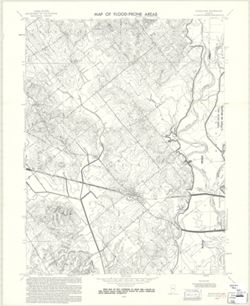
- Subject:
- Topical Subject: Flood forecasting, Geographic Subject: Knox County (Ind.), Topical Subject: Floodplains, Geographic Subject: Daviess County (Ind.), and Topi...
- Creator:
- Geological Survey (U.S.)
- Publisher:
- Geological Survey (U.S.)
- Date Created:
- 1970
- Identifier:
- VAC3073-M-00649
- Genre:
- Thematic maps
- Geographic Location:
- Coordinates: W0872230 W0871500 N0384500 N0383730
- Related URL:
- Catalog URL: https://iucat.iu.edu/catalog/18416340
- Abstract:
- Filing title: Wheatland, Ind. Relief shown by contours and spot heights. Contour interval 10 feet. Includes quadrangle location map. Shows portion of Knox Co...
- Call Number:
- G4091.C32 s24 .G4 Wheatland, Ind. 1970
- Caption:
- Imprint: Washington, D.C. : Interior--Geological Survey, [1970]
- Physical Description:
- Dimensions: 59 x 45 or smaller and Scale: 1:24,000
- Alternate Identifier:
- Alternate ID: CAW5372BB and Title Control Number: a18416340
- Persistent URL:
- https://purl.dlib.indiana.edu/iudl/images/VAC3073/VAC3073-M-00649
- Provenance:
- United States Department of the Interior, Geological Survey. Map of flood-prone areas : [Indiana]. Washington, D.C. : The Survey, 1969-.
