
Search Constraints
You searched for:
Pages
0-99 pages
Remove constraint Pages: 0-99 pages
Publisher
Indiana. Department of Geology and Natural Resources
Remove constraint Publisher: Indiana. Department of Geology and Natural Resources
« Previous |
1 - 10 of 196
|
Next »
Search Results
-
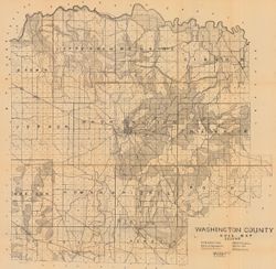
- Subject:
- Geographic Subject: Washington County (Ind.) and Topical Subject: Soils
- Creator:
- Indiana. Department of Geology and Natural Resources
- Publisher:
- Indiana. Department of Geology and Natural Resources
- Date Created:
- 1908
- Identifier:
- VAC3073-M-00603
- Genre:
- Thematic maps
- Geographic Location:
- Coordinates: W0861836 W0855051 N0384700 N0382504
- Related URL:
- Catalog URL: https://iucat.iu.edu/catalog/16096233
- Abstract:
- Shows railroads, dirt roads, improved roads, school houses, and churches. Detached from: Soil survey of Monroe, Brown, Lawrence, Martin, Orange, Washingto...
- Call Number:
- G4093.W5J3 1907 .I53
- Caption:
- Imprint: [Indianapolis] : [Indiana Department of Geology and Natural Resources], [1908]
- Physical Description:
- Scale: Approximately 1:63,360 and Dimensions: 67 x 68 cm
- Alternate Identifier:
- Title Control Number: a16096233 and Alternate ID: 390726IP
- Persistent URL:
- https://purl.dlib.indiana.edu/iudl/images/VAC3073/VAC3073-M-00603
- Provenance:
- 32nd Annual Report (1907) / Indiana. Department of Geology and Natural Resources.
-
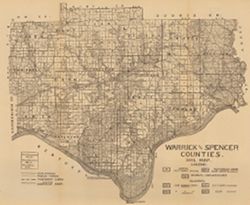
- Subject:
- Geographic Subject: Spencer County (Ind.), Geographic Subject: Warrick County (Ind.), and Topical Subject: Soils
- Creator:
- Shannon, C. W. (Charles William), 1879-1934
- Publisher:
- Indiana. Department of Geology and Natural Resources
- Date Created:
- 1910
- Identifier:
- VAC3073-M-00654
- Genre:
- Thematic maps
- Geographic Location:
- Coordinates: W0872823 W0864559 N0381446 N0374653
- Related URL:
- Catalog URL: https://iucat.iu.edu/catalog/16123910
- Abstract:
- Shows public roads and railroads. Detached from: A soil survey of Vanderburgh, Gibson, and Pike, and parts of Warrick and Spencer counties / Chas. W. Shan...
- Call Number:
- G4093.S5J3 1909 .S5
- Caption:
- Imprint: [Indianapolis] : [Indiana Department of Geology and Natural Resources], [1910]
- Physical Description:
- Dimensions: 44 x 52 cm and Scale: Approximately 1:126,720
- Alternate Identifier:
- Title Control Number: a16123910 and Alternate ID: 390726IP
- Persistent URL:
- https://purl.dlib.indiana.edu/iudl/images/VAC3073/VAC3073-M-00654
- Provenance:
- 34th Annual Report (1909) / Indiana. Department of Geology and Natural Resources.
-
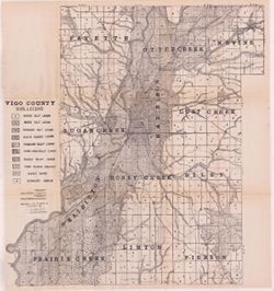
- Subject:
- Geographic Subject: Vigo County (Ind.), Topical Subject: Soils, Topical Subject: Geology, and Topical Subject: Mines and mineral resources
- Creator:
- Shannon, M. E., Shannon, C. W. (Charles William), 1879-1934, and United States. Bureau of Soils
- Publisher:
- Indiana. Department of Geology and Natural Resources
- Date Created:
- 1912
- Identifier:
- VAC3073-M-01092
- Genre:
- Thematic maps
- Geographic Location:
- Coordinates: W0873635 W0871156 N0393629 N0391532
- Related URL:
- Catalog URL: https://iucat.iu.edu/catalog/16131306
- Abstract:
- Shows dirt roads and improved public roads, railroads, school houses, cemeteries, and churches. Detached from: Soil survey of Clay, Knox, Sullivan, and Vi...
- Call Number:
- G4093.V5J3 1911 .S5
- Caption:
- Imprint: [Indianapolis] : [Department of Geology and Natural Resources, Indiana], [1912] [Indianapolis] : [Wm. B. Burford], [1912]
- Physical Description:
- Dimensions: 64 x 59 cm and Scale: Approximately 1:63,360
- Alternate Identifier:
- Title Control Number: a16131306 and Alternate ID: 390726IP
- Persistent URL:
- https://purl.dlib.indiana.edu/iudl/images/VAC3073/VAC3073-M-01092
- Provenance:
- 36th Annual Report (1911) / Indiana. Department of Geology and Natural Resources.
-
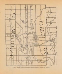
- Subject:
- Geographic Subject: Montezuma (Ind.), Topical Subject: Shale, Topical Subject: Clay industries, Geographic Subject: Vermillion County (Ind.), Topical Subject...
- Creator:
- Blatchley, Raymond S. (Raymond Sillliman)
- Publisher:
- Indiana. Department of Geology and Natural Resources
- Date Created:
- 1905
- Identifier:
- VAC3073-M-00274
- Genre:
- Geological maps
- Geographic Location:
- Coordinates: W0872510 W0872023 N0395020 N0394532
- Related URL:
- Catalog URL: https://iucat.iu.edu/catalog/18282337
- Abstract:
- Shows the location of clay and shale deposits as well as the locations of brick, clay works, and tile companies. At head of title: Fig. 5. "R.S.B. Del.&...
- Call Number:
- G4094.M68H5 1904 .V53
- Caption:
- Imprint: [Indianapolis] : [Wm. B. Burford], [1905] and Imprint: [Indianapolis] : [Indiana Department of Geology and Natural Resources], [1905]
- Physical Description:
- Dimensions: 23 x 19 cm and Scale: Approximately 1:53,000
- Alternate Identifier:
- Alternate ID: 390726IP and Title Control Number: a18282337
- Persistent URL:
- https://purl.dlib.indiana.edu/iudl/images/VAC3073/VAC3073-M-00274
- Provenance:
- 29th Annual Report (1904) / Indiana. Department of Geology and Natural Resources.
-
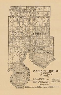
- Subject:
- Topical Subject: Soils and Geographic Subject: Vanderburgh County (Ind.)
- Creator:
- Shannon, C. W. (Charles William), 1879-1934
- Publisher:
- Indiana. Department of Geology and Natural Resources
- Date Created:
- 1910
- Identifier:
- VAC3073-M-00292
- Genre:
- Thematic maps
- Geographic Location:
- Coordinates: W0874202 W0872657 N0381006 N0374932
- Related URL:
- Catalog URL: https://iucat.iu.edu/catalog/16123565
- Abstract:
- Shows railroads and public roads. Detached from: A soil survey of Vanderburgh, Gibson, and Pike, and parts of Warrick and Spencer counties / Chas. W. Shan...
- Call Number:
- G4093.V3J3 1909 .S5
- Caption:
- Imprint: [Indianapolis] : [Indiana Department of Geology and Natural Resources], [1910]
- Physical Description:
- Dimensions: 37 x 24 cm and Scale: Approximately 1:126,720
- Alternate Identifier:
- Alternate ID: 390726IP and Title Control Number: a16123565
- Persistent URL:
- https://purl.dlib.indiana.edu/iudl/images/VAC3073/VAC3073-M-00292
- Provenance:
- 34th Annual Report (1909) / Indiana. Department of Geology and Natural Resources.
-
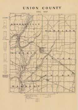
- Subject:
- Topical Subject: Soils and Geographic Subject: Union County (Ind.)
- Creator:
- Indiana. Department of Geology and Natural Resources
- Publisher:
- Indiana. Department of Geology and Natural Resources
- Date Created:
- 1910
- Identifier:
- VAC3073-M-00859
- Genre:
- Thematic maps
- Geographic Location:
- Coordinates: W0850210 W0844851 N0394345 N0393119
- Related URL:
- Catalog URL: https://iucat.iu.edu/catalog/16124317
- Abstract:
- Shows railroads, dirt roads, and gravel roads. Includes notes on general topography. Detached from: A soil survey of Randolph, Wayne, Henry, Rush, Fayette...
- Call Number:
- G4093.U5J3 1909 .I53
- Caption:
- Imprint: [Indianapolis] : [Indiana Department of Geology and Natural Resources], [1910]
- Physical Description:
- Dimensions: 25 x 21 cm and Scale: Approximately 1:95,000
- Alternate Identifier:
- Title Control Number: a16124317 and Alternate ID: 390726IP
- Persistent URL:
- https://purl.dlib.indiana.edu/iudl/images/VAC3073/VAC3073-M-00859
- Provenance:
- 34th Annual Report (1909) / Indiana. Department of Geology and Natural Resources.
-
- Subject:
- Topical Subject: Mines and mineral resources, Topical Subject: Geology, Topical Subject: IGS Annual Reports, Geographic Subject: Perry County (Ind.), and Top...
- Publisher:
- Indiana. Department of Geology and Natural Resources
- Date Created:
- 1898
- Identifier:
- VAC3073-M-00991
- Genre:
- Geological maps and Geological cross-sections
- Geographic Location:
- Coordinates: W0864825 W0863629 N0380227 N0375602
- Related URL:
- Catalog URL: https://iucat.iu.edu/catalog/18349350
- Abstract:
- ncludes index map and 16 stratigraphic columns showing coal measurements. Plate LXVII. "Troy. Tell City." Detached from: Seventh annual report o...
- Call Number:
- G4093.P2H9 1876 .T69
- Caption:
- Imprint: [Indianapolis] : [Sentinel Company, printers], [1876] and Imprint: [Indianapolis] : [Geological Survey of Indiana], [1876]
- Physical Description:
- Scale: Approximately 1:63,360. Vertical scale indeterminable and Dimensions: on sheet 21 x 26 cm
- Alternate Identifier:
- Title Control Number: a18349350 and Alternate ID: 390726IP
- Persistent URL:
- https://purl.dlib.indiana.edu/iudl/images/VAC3073/VAC3073-M-00991
- Provenance:
- 7th Annual Report (1875) / Indiana. Geological Survey.
-
![Township 5 south, range 8 west [Indiana]](https://iiif.uits.iu.edu/iiif/2/df65wb20n%2Ffiles%2F076a45f7-4ea5-41d9-9a65-3d0fbf136b54/full/250,/0/default.jpg)
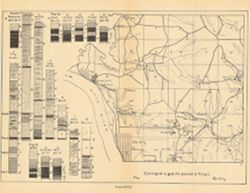
- Subject:
- Topical Subject: Geology, Stratigraphic, Topical Subject: IGS Annual Reports, Geographic Subject: Warrick County (Ind.), and Topical Subject: Coal reserves
- Publisher:
- Indiana. Department of Geology and Natural Resources
- Date Created:
- 1899
- Identifier:
- VAC3073-M-00913
- Genre:
- Geological cross-sections and Geological maps
- Geographic Location:
- Coordinates: W0872133 W0871442 N0380715 N0380157
- Related URL:
- Catalog URL: https://iucat.iu.edu/catalog/18418184
- Abstract:
- Title from caption. Other title from Bureau of Land Management database: IN T5S R8W. 16 columnar sections showing coal measures and location map for unnamed ...
- Call Number:
- G4093.W4H9 1898 .T6
- Caption:
- Imprint: [Indianapolis] : [Wm. B. Burford], [1899] and Imprint: [Indianapolis] : [Indiana, Dept. of Geology and Natural History], [1899]
- Physical Description:
- Dimensions: 23 x 27 cm and Scale: Approximately 1:63,360
- Alternate Identifier:
- Alternate ID: 390726IP and Title Control Number: a18418184
- Persistent URL:
- https://purl.dlib.indiana.edu/iudl/images/VAC3073/VAC3073-M-00913
- Provenance:
- 23rd Annual Report (1898) / Indiana. Department of Geology and Natural Resources.
-
![Township 2 south, range 7 west [Indiana]](https://iiif.uits.iu.edu/iiif/2/2b88rf889%2Ffiles%2F8503c6af-2a95-4ca4-acde-dcd4736a0d0c/full/250,/0/default.jpg)
- Subject:
- Topical Subject: Coal reserves, Geographic Subject: Pike County (Ind.), Topical Subject: Geology, Stratigraphic, and Topical Subject: IGS Annual Reports
- Publisher:
- Indiana. Department of Geology and Natural Resources
- Date Created:
- 1899
- Identifier:
- VAC3073-M-00614
- Genre:
- Geological cross-sections and Geological maps
- Geographic Location:
- Coordinates: W0871432 W0870735 N0382243 N0381721
- Related URL:
- Catalog URL: http://www.iucat.iu.edu/catalog/18418128
- Abstract:
- Relief shown by profile. Other title from Bureau of Land Management database: IN T2S R7W. 20 columnar sections showing coal measures and location map for unn...
- Call Number:
- G4093.P4H9 1898 .T6
- Caption:
- Imprint: [Indianapolis] : [Wm. B. Burford], [1899] and Imprint: [Indianapolis] : [Indiana, Dept. of Geology and Natural History], [1899]
- Physical Description:
- Dimensions: 23 x 27 cm and Scale: Approximately 1:63,360. Vertical scale not given
- Alternate Identifier:
- Title Control Number: a18418128 and Alternate ID: 390726IP
- Persistent URL:
- https://purl.dlib.indiana.edu/iudl/images/VAC3073/VAC3073-M-00614
- Provenance:
- 23rd Annual Report (1898) / Indiana. Department of Geology and Natural Resources.
-
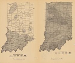
- Subject:
- Geographic Subject: Indiana, Topical Subject: Precipitation (Meteorology), and Topical Subject: IGS Annual Reports
- Publisher:
- Indiana. Department of Geology and Natural Resources
- Date Created:
- 1911
- Identifier:
- VAC3073-M-00072
- Genre:
- Thematic maps
- Geographic Location:
- Coordinates: W0880500 W0844700 N0414500 N0374600
- Related URL:
- Catalog URL: https://iucat.iu.edu/catalog/18307828
- Abstract:
- 2 maps on one sheet. Shows rainfall over the state of Indiana in inches. "Fig. 2." Detached from: Water power of Indiana / W.M. Tucker. In India...
- Call Number:
- G4091.C88 1909 .T6
- Caption:
- Imprint: [Indianapolis] : [Indiana Department of Geology and Natural Resources], [1911]
- Physical Description:
- Scale: Scale not given. and Dimensions: on sheet 23 x 27 cm
- Alternate Identifier:
- Alternate ID: 390726IP and Title Control Number: a18307828
- Persistent URL:
- https://purl.dlib.indiana.edu/iudl/images/VAC3073/VAC3073-M-00072
- Provenance:
- 35th Annual Report (1910) / Indiana. Department of Geology and Natural Resources.
