
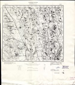
Search Constraints
« Previous |
1 - 10 of 28
|
Next »
Search Results
-
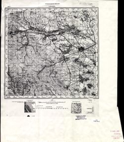
- Description:
- 1894
- Subject:
- Geographic Subject: Radauti, Topical Subject: Maps, and Topical Subject: Soviet Union
- Publisher:
- Управление военных топографов
- Language:
- Russian
- Date Created:
- 1896
- Identifier:
- VAC9619-001476
- Genre:
- Military Maps and Topographic Maps
- Geographic Location:
- Coordinates: 47.6667, 25.5, 48, 26
- Related URL:
- DataCORE Dataset Download: https://datacore.iu.edu/concern/data_sets/x059c828x
- Abstract:
- Modern area represented: Radauti, Suceava county, Romania
- Call Number:
- G7000 s100 .S7 sheet L-35-4
- Caption:
- Для служебного пользования
- City:
- Рэдэуци (Radauti)
- Copyright Holder:
- No Copyright - United States
- Country:
- Румыния (Romania)
- Physical Description:
- Scale: 1:100,000
- Persistent URL:
- http://purl.dlib.indiana.edu/iudl/images/VAC9619/VAC9619-001476
- Provenance:
- CIA Map Library
-

- Description:
- 1894
- Subject:
- Geographic Subject: Luokė, Topical Subject: Soviet Union, and Topical Subject: Maps
- Publisher:
- Генеральный штаб РККА
- Language:
- Russian
- Date Created:
- 1896
- Identifier:
- VAC9619-003896
- Genre:
- Topographic Maps and Military Maps
- Geographic Location:
- Coordinates: 55.667, 22.5, 56, 23
- Related URL:
- DataCORE Dataset Download: https://datacore.iu.edu/concern/data_sets/000000841
- Abstract:
- Modern area represented: Luokė, Telšiai county, Lithuania
- Call Number:
- G7000 s100 .S7 sheet N-34-10
- City:
- Луока (Luokė)
- Copyright Holder:
- No Copyright - United States
- Country:
- Литва (Lithuania)
- Physical Description:
- Scale: 1:100,000
- Persistent URL:
- http://purl.dlib.indiana.edu/iudl/images/VAC9619/VAC9619-003896
- Provenance:
- DMA Topographic Center, Army Map Service Library
-
- Description:
- 1883
- Subject:
- Topical Subject: Soviet Union, Geographic Subject: Buftea, and Topical Subject: Maps
- Publisher:
- Генеральный штаб РККА
- Language:
- Russian
- Date Created:
- 1896
- Identifier:
- VAC9619-001789
- Genre:
- Military Maps and Topographic Maps
- Geographic Location:
- Coordinates: 44.3333, 25.5, 44.6667, 26
- Related URL:
- DataCORE Dataset Download: https://datacore.iu.edu/concern/data_sets/wd375w962
- Abstract:
- Modern area represented: Buftea, Ilfov county, Romania
- Call Number:
- G7000 s100 .S7 sheet L-35-124
- City:
- Буфтя (Buftea)
- Copyright Holder:
- No Copyright - United States
- Country:
- Румыния (Romania)
- Physical Description:
- Scale: 1:100,000
- Persistent URL:
- http://purl.dlib.indiana.edu/iudl/images/VAC9619/VAC9619-001789
- Provenance:
- DMA Topographic Center, Army Map Service Library, OMAHA, Atlasblatt, Library of Congress Geography & Map Division
-
- Description:
- 1889
- Subject:
- Geographic Subject: Moineşti, Topical Subject: Soviet Union, and Topical Subject: Maps
- Publisher:
- Генеральный штаб РККА
- Language:
- Russian
- Date Created:
- 1896
- Identifier:
- VAC9619-001738
- Genre:
- Topographic Maps and Military Maps
- Geographic Location:
- Coordinates: 46.3333, 26, 46.6667, 26.5
- Related URL:
- DataCORE Dataset Download: https://datacore.iu.edu/concern/data_sets/x346d495t
- Abstract:
- Modern area represented: Moineşti, Bacău county, Romania
- Call Number:
- G7000 s100 .S7 sheet L-35-53
- City:
- Мойнешти (Moineşti)
- Copyright Holder:
- No Copyright - United States
- Country:
- Румыния (Romania)
- Physical Description:
- Scale: 1:100,000
- Persistent URL:
- http://purl.dlib.indiana.edu/iudl/images/VAC9619/VAC9619-001738
- Provenance:
- DMA Topographic Center, Army Map Service Library, OMAHA, Atlasblatt, Library of Congress Geography & Map Division
-
- Description:
- 1889
- Subject:
- Geographic Subject: Moineşti, Topical Subject: Maps, and Topical Subject: Soviet Union
- Publisher:
- Генеральный штаб РККА
- Language:
- Russian
- Date Created:
- 1896
- Identifier:
- VAC9619-001730
- Genre:
- Military Maps and Topographic Maps
- Geographic Location:
- Coordinates: 46.3333, 26, 46.6667, 26.5
- Related URL:
- DataCORE Dataset Download: https://datacore.iu.edu/concern/data_sets/dr26xz22f
- Abstract:
- Modern area represented: Moineşti, Bacău county, Romania
- Call Number:
- G7000 s100 .S7 sheet L-35-53
- City:
- Мойнешти (Moineşti)
- Copyright Holder:
- No Copyright - United States
- Country:
- Румыния (Romania)
- Physical Description:
- Scale: 1:100,000
- Persistent URL:
- http://purl.dlib.indiana.edu/iudl/images/VAC9619/VAC9619-001730
- Provenance:
- Library of Congress G & M Division, Army Map Service Library
-
- Description:
- 1893
- Subject:
- Topical Subject: Maps, Topical Subject: Soviet Union, and Geographic Subject: Adjud
- Publisher:
- Генеральный штаб РККА
- Language:
- Russian
- Date Created:
- 1896
- Identifier:
- VAC9619-001612
- Genre:
- Topographic Maps and Military Maps
- Geographic Location:
- Coordinates: 46, 27, 46.3333, 27.5
- Related URL:
- DataCORE Dataset Download: https://datacore.iu.edu/concern/data_sets/8w32r630d
- Abstract:
- Modern area represented: Adjud, Vrancea county, Romania
- Call Number:
- G7000 s100 .S7 sheet L-35-67
- City:
- Аджуд Ноуа (Adjudu Nou)
- Copyright Holder:
- No Copyright - United States
- Country:
- Румыния (Romania)
- Physical Description:
- Scale: 1:100,000
- Persistent URL:
- http://purl.dlib.indiana.edu/iudl/images/VAC9619/VAC9619-001612
- Provenance:
- CIA Map Library
-
- Description:
- 1893
- Subject:
- Topical Subject: Soviet Union, Topical Subject: Maps, and Geographic Subject: Adjud
- Publisher:
- Генеральный штаб РККА
- Language:
- Russian
- Date Created:
- 1896
- Identifier:
- VAC9619-001602
- Genre:
- Topographic Maps and Military Maps
- Geographic Location:
- Coordinates: 46, 27, 46.3333, 27.5
- Related URL:
- DataCORE Dataset Download: https://datacore.iu.edu/concern/data_sets/5t34sk28v
- Abstract:
- Modern area represented: Adjud, Vrancea county, Romania
- Call Number:
- G7000 s100 .S7 sheet L-35-67
- City:
- Аджуд Ноуа (Adjudu Nou)
- Copyright Holder:
- No Copyright - United States
- Country:
- Румыния (Romania)
- Physical Description:
- Scale: 1:100,000
- Persistent URL:
- http://purl.dlib.indiana.edu/iudl/images/VAC9619/VAC9619-001602
- Provenance:
- DMA Topographic Center, Army Map Service Library, OMAHA, Library of Congress Geography & Map Division
-
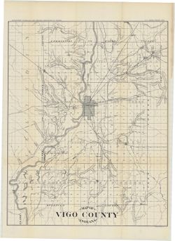
- Subject:
- Topical Subject: IGS Annual Reports and Geographic Subject: Vigo County (Ind.)
- Publisher:
- Indiana. Department of Geology and Natural Resources
- Date Created:
- 1896
- Identifier:
- VAC3073-M-01452
- Genre:
- Maps
- Geographic Location:
- Coordinates: W0873635 W0871156 N0393629 N0391532
- Related URL:
- Catalog URL: https://iucat.iu.edu/catalog/16180108
- Abstract:
- Relief shown by hachures. Shows roads and railroads. Detached from: Geology of Vigo County, Indiana / J.T. Scovell. In Indiana Department of Geology and N...
- Call Number:
- G4093.V5 1896 .I53
- Caption:
- Imprint: [Indianapolis] : Department of Geology and Natural Resources of Indiana, [1897] and Imprint: Indianapolis, Ind. : Wm. B. Burford, [1897]
- Physical Description:
- Dimensions: 55 x 43 cm
- Alternate Identifier:
- Title Control Number: a16180108 and Alternate ID: 390726IP
- Persistent URL:
- https://purl.dlib.indiana.edu/iudl/images/VAC3073/VAC3073-M-01452
- Provenance:
- 21st Annual Report (1896) / Indiana. Department of Geology and Natural Resources.
-
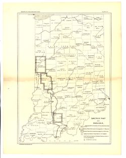
- Subject:
- Topical Subject: Quarries and quarrying, Topical Subject: IGS Annual Reports, Geographic Subject: Indiana, Topical Subject: Sandstone, and Topical Subject: M...
- Creator:
- Hopkins, Thomas Cramer, 1861-1935 and Kindle, E. M. (Edward Martin), 1869-1940
- Publisher:
- Indiana. Department of Geology and Natural Resources
- Date Created:
- 1896
- Identifier:
- VAC3073-M-01179
- Genre:
- Index maps and Thematic maps
- Geographic Location:
- Coordinates: W0880500 W0844700 N0414500 N0374600
- Related URL:
- Catalog URL: https://iucat.iu.edu/catalog/18416374
- Abstract:
- Shows Mansfield sandstone areas and quarries. Plate VIII. Detached from: Area of Mansfield sandstone / mapped by T.C. Hopkins [and] E.M. Kindle. In Indian...
- Call Number:
- G4091.H5 1895 .H6
- Caption:
- Imprint: [Indianapolis] : [Indiana Department of Geology and Natural Resources], [1896] and Imprint: Indianapolis : Wm. B. Burford, [1896]
- Physical Description:
- Scale: Approximately 1:1,788,600 and Dimensions: 30 x 23 cm
- Alternate Identifier:
- Alternate ID: 390726IP and Title Control Number: a18416374
- Persistent URL:
- https://purl.dlib.indiana.edu/iudl/images/VAC3073/VAC3073-M-01179
- Provenance:
- 20th Annual Report (1895) / Indiana. Department of Geology and Natural Resources.
-
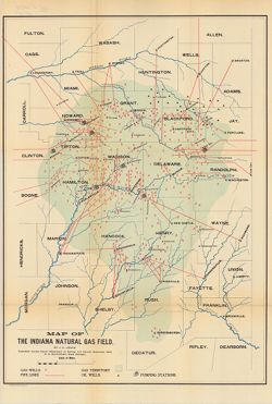
- Subject:
- Topical Subject: IGS Annual Reports, Topical Subject: Gas fields, Topical Subject: Gas wells, Geographic Subject: Indiana, Topical Subject: Oil wells, and To...
- Creator:
- Leach, J. C.
- Publisher:
- Indiana. Department of Geology and Natural Resources
- Date Created:
- 1896
- Identifier:
- VAC3073-M-01064
- Genre:
- Geological maps
- Geographic Location:
- Coordinates: W0864100 W0844800 N0410000 N0390500
- Related URL:
- Catalog URL: https://iucat.iu.edu/catalog/4022271
- Abstract:
- Shows gas wells, pipelines, pumping stations, and oil wells in east-central Indiana. Detached from: Report of the State Natural Gas Supervisor / J.C. Leac...
- Call Number:
- G4091.H8 1895 .L4
- Caption:
- Imprint: Indianapolis, Ind. : Wm. B. Burford, Lith., [1896]
- Physical Description:
- Dimensions: 56 x 39 cm and Scale: Approximately 1:434,000
- Alternate Identifier:
- Title Control Number: a18225037 and Alternate ID: 390726IP
- Persistent URL:
- https://purl.dlib.indiana.edu/iudl/images/VAC3073/VAC3073-M-01064
- Provenance:
- 20th Annual Report (1895) / Indiana. Department of Geology and Natural Resources.

- « Previous
- Next »
- 1
- 2
- 3