
Search Constraints
You searched for:
Publisher
Indiana. Department of Geology and Natural Resources
Remove constraint Publisher: Indiana. Department of Geology and Natural Resources
Search Results
-
- Subject:
- Topical Subject: IGS Annual Reports, Topical Subject: Rivers, Geographic Subject: White River Valley (Ind.), Geographic Subject: Shoals (Ind.), Topical Subje...
- Publisher:
- Indiana. Department of Geology and Natural Resources
- Date Created:
- 1911
- Identifier:
- VAC3073-M-00393
- Genre:
- Topographic maps
- Geographic Location:
- Coordinates: W0864835 W0864633 N0384050 N0383903
- Related URL:
- Catalog URL: https://iucat.iu.edu/catalog/18418396
- Abstract:
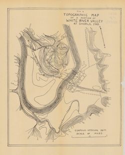
- Relief shown by contours. Contour interval 10 feet. Shows proposed canal routes, proposed dam location, and power house. At head of title: "Fig. 4."...
- Call Number:
- G4093.M5C2 1910 .T6
- Caption:
- Imprint: [Indianapolis] : [Indiana Department of Geology and Natural Resources], [1911] and Imprint: [Indianapolis] : [Wm. B. Burford], [1911]
- Physical Description:
- Scale: Approximately 1:11,750 and Dimensions: 28 x 23 cm
- Alternate Identifier:
- Title Control Number: a18418396 and Alternate ID: 390726IP
- Persistent URL:
- https://purl.dlib.indiana.edu/iudl/images/VAC3073/VAC3073-M-00393
- Provenance:
- 35th Annual Report (1910) / Indiana. Department of Geology and Natural Resources.
-
- Subject:
- Geographic Subject: Owen County (Ind.), Geographic Subject: Eel River Valley (Ind. : Valley), Topical Subject: IGS Annual Reports, and Topical Subject: Valleys
- Publisher:
- Indiana. Department of Geology and Natural Resources
- Date Created:
- 1911
- Identifier:
- VAC3073-M-00830
- Genre:
- Topographic maps
- Geographic Location:
- Coordinates: W0865003 W0864726 N0392725 N0392513
- Related URL:
- Catalog URL: https://iucat.iu.edu/catalog/18418393
- Abstract:
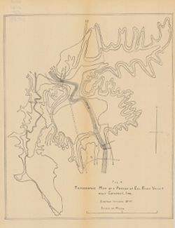
- Relief shown by contours. Contour interval 20 feet. Shows upper falls dam and proposed lower falls dams now located within the Cataract Falls State Recreatio...
- Call Number:
- G4092.O8C2 1910 .T6
- Caption:
- Imprint: [Indianapolis] : [Wm. B. Burford], [1911] and Imprint: [Indianapolis] : [Indiana Department of Geology and Natural Resources], [1911]
- Physical Description:
- Scale: Approximately 1:7,650 and Dimensions: 31 x 25 cm
- Alternate Identifier:
- Title Control Number: a18418393 and Alternate ID: 390726IP
- Persistent URL:
- https://purl.dlib.indiana.edu/iudl/images/VAC3073/VAC3073-M-00830
- Provenance:
- 35th Annual Report (1910) / Indiana. Department of Geology and Natural Resources.
-
- Subject:
- Geographic Subject: Maxinkuckee, Lake (Ind.), Topical Subject: IGS Annual Reports, Topical Subject: Lakes, Geographic Subject: Marshall County (Ind.), Geogra...
- Creator:
- Scovell, J. T. (Josiah Thomas), 1841-
- Publisher:
- Indiana. Department of Geology and Natural Resources
- Date Created:
- 1901
- Identifier:
- VAC3073-M-00003
- Genre:
- Bathymetric maps and Topographic maps
- Geographic Location:
- Coordinates: W0862605 W0862248 N0411337 N0411052
- Related URL:
- Catalog URL: https://iucat.iu.edu/catalog/18279165
- Abstract:
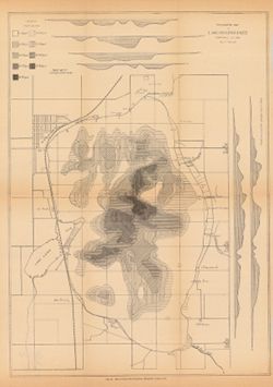
- Depth shown by isolines, patterning, and profile. In addition to Lake Maxinkuckee, the map shows local sites including Marmont (now Culver), a railroad, mill...
- Call Number:
- G4092.M33 1900 .S36
- Caption:
- Imprint: [Indianapolis] : [Indiana. Department of Geology and Natural Resources], [1901]
- Physical Description:
- Scale: Approximately 1:14,630 and Dimensions: on sheet 44 x 33 cm
- Alternate Identifier:
- Title Control Number: a18279165 and Alternate ID: 390726IP
- Persistent URL:
- https://purl.dlib.indiana.edu/iudl/images/VAC3073/VAC3073-M-00003
- Provenance:
- 25th Annual Report (1900) / Indiana. Department of Geology and Natural Resources.
-
- Subject:
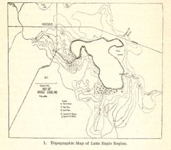
- Topical Subject: Lakes, Geographic Subject: Winona Lake (Ind. : Lake), Geographic Subject: Warsaw (Ind.), and Topical Subject: IGS Annual Reports
- Publisher:
- Indiana. Department of Geology and Natural Resources
- Date Created:
- 1904
- Identifier:
- VAC3073-M-01577
- Genre:
- Topographic maps
- Related URL:
- Catalog URL: new.iucat.iu.edu/catalog/4022271
- Call Number:
- QE109 .A2 1903
- Caption:
- Imprint: Indianapolis : 1904.
- Persistent URL:
- https://purl.dlib.indiana.edu/iudl/images/VAC3073/VAC3073-M-01577
- Provenance:
- 28th Annual Report (1903) / Indiana. Department of Geology and Natural Resources.
-
- Subject:
- Geographic Subject: Indiana and Topical Subject: IGS Annual Reports
- Creator:
- Hesler, R. S.
- Publisher:
- Indiana. Department of Geology and Natural Resources
- Date Created:
- 1913
- Identifier:
- VAC3073-M-01536
- Genre:
- Topographic maps
- Geographic Location:
- Coordinates: W0880500 W0844700 N0414500 N0374600
- Related URL:
- Catalog URL: https://iucat.iu.edu/catalog/18466085
- Abstract:
- Relief shown by choropleth methods. "Note: Data--railroad elevations, Plan--after Leverett." Detached from: Topography of Indiana--Map / Edward ...
- Call Number:
- G4091.C2 1913 .H4
- Caption:
- Imprint: [Indianapolis] : [Indiana Department of Geology and Natural Resources], [1913]
- Physical Description:
- Dimensions: on sheet 73 x 46 cm and Scale: Scale not given.
- Alternate Identifier:
- Alternate ID: 390726IP and Title Control Number: a18466085
- Persistent URL:
- https://purl.dlib.indiana.edu/iudl/images/VAC3073/VAC3073-M-01536
- Provenance:
- 37th Annual Report (1912) / Indiana. Department of Geology and Natural Resources.
-

- Subject:
- Geographic Subject: Indiana, Topical Subject: IGS Annual Reports, and Topical Subject: Geology, Stratigraphic--Ordovician
- Creator:
- Cumings, E. R. (Edgar Roscoe), 1874-1967
- Publisher:
- Indiana. Department of Geology and Natural Resources
- Date Created:
- 1908
- Identifier:
- VAC3073-M-00874
- Genre:
- Geological cross-sections
- Geographic Location:
- Coordinates: W0880500 W0844700 N0414500 N0374600
- Related URL:
- Catalog URL: https://iucat.iu.edu/catalog/18307667
- Abstract:
- 3 sections on one sheet. Title from caption. Shows strategraphic measurements for sections 5.9A, 1.38A, and 1.38B. Detached from: The stratigraphy and pal...
- Call Number:
- G4091.C57 1907 .Z47
- Caption:
- Imprint: [Indianapolis] : [Indiana Department of Geology and Natural Resources], [1908]
- Physical Description:
- Dimensions: 44 x 19 cm
- Alternate Identifier:
- Title Control Number: a18307667 and Alternate ID: 390726IP
- Persistent URL:
- https://purl.dlib.indiana.edu/iudl/images/VAC3073/VAC3073-M-00874
- Provenance:
- 32nd Annual Report (1907) / Indiana. Department of Geology and Natural Resources.
-
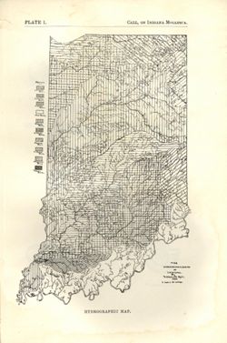
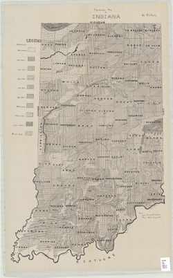
- Subject:
- Topical Subject: Watersheds and Geographic Subject: Indiana
- Creator:
- Call, Richard Ellsworth, 1856-1917
- Publisher:
- Indiana. Department of Geology and Natural Resources
- Date Created:
- 1900
- Identifier:
- VAC3073-M-01572
- Genre:
- Maps
- Geographic Location:
- Coordinates: W0880500 W0844700 N0414500 N0374600
- Related URL:
- Catalog URL: https://iucat.iu.edu/catalog/18418197
- Abstract:
- At foot of map: "Hydrographic map." At head of map: "Plate 1 -- Call, On Indiana mollusca." Detached from: A descriptive illustrated cata...
- Call Number:
- G4091.C315 1896 .C3
- Caption:
- Imprint: [Indianapolis] : [Department of Geology and Natural Resources], [1900] and Imprint: [Indianapolis] : [Wm. B. Burford], [1900]
- Physical Description:
- Dimensions: on sheet 22 x 15 cm and Scale: Approximately 1:1,267,200. 1 inch = 20 miles
- Alternate Identifier:
- Alternate ID: 390726IP and Title Control Number: a18418197
- Persistent URL:
- https://purl.dlib.indiana.edu/iudl/images/VAC3073/VAC3073-M-01572
- Provenance:
- 24th Annual Report (1899) / Indiana. Department of Geology and Natural Resources.
-
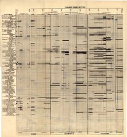
- Subject:
- Topical Subject: Stratigraphic correlation, Topical Subject: Geology, Stratigraphic--Ordovician, Topical Subject: Bilateria, Fossil, Topical Subject: IGS Ann...
- Creator:
- Cumings, E. R. (Edgar Roscoe), 1874-1967 and Galloway, J. J. (Jesse James), 1882-1962
- Publisher:
- Indiana. Department of Geology and Natural Resources
- Date Created:
- 1913
- Identifier:
- VAC3073-M-01183
- Genre:
- Cartographic materials and Graphs
- Geographic Location:
- Coordinates: W0880500 W0844700 N0414500 N0374600
- Related URL:
- Catalog URL: https://iucat.iu.edu/catalog/18416521
- Abstract:
- Sections on one sheet. Title from caption. Diagram showing stratagraphic measurements for bilateria fossils in the Tanner's Creek Formation from the Cinc...
- Call Number:
- G4091.C57 1912 .C8
- Caption:
- Imprint: [Indianapolis] : [Department of Geology and Natural Resources], [1913] and Imprint: [Indianapolis] : [Wm. B. Burford, contractor for state printing ...
- Physical Description:
- Scale: Scale not given. Vertical scale approximately 1:550 and Dimensions: 38 x 41 cm
- Alternate Identifier:
- Title Control Number: a18416521 and Alternate ID: 390726IP
- Persistent URL:
- https://purl.dlib.indiana.edu/iudl/images/VAC3073/VAC3073-M-01183
- Provenance:
- 37th Annual Report (1912) / Indiana. Department of Geology and Natural Resources.
-
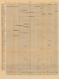
- Subject:
- Geographic Subject: Wayne County (Ind.), Topical Subject: Geology, Topical Subject: Paleontology, Geographic Subject: Tanners Creek (Ind. : Creek), Topical S...
- Creator:
- Cumings, E. R. (Edgar Roscoe), 1874-1967
- Publisher:
- Indiana. Department of Geology and Natural Resources
- Date Created:
- 1908
- Identifier:
- VAC3073-M-00692
- Genre:
- Graphs
- Geographic Location:
- Coordinates: W0845749 W0844849 N0395257 N0390333
- Related URL:
- Catalog URL: https://iucat.iu.edu/catalog/18298805
- Abstract:
- Title derived from captions. Chart showing stratigraphic measurements for paleontology samples collected around Tanner's Creek in Dearborn County and Ric...
- Call Number:
- G4091.C57 1908 .C86
- Caption:
- Imprint: [Indianapolis] : [Indiana Dept. of Geology and Natural Resources], [1908]
- Physical Description:
- Dimensions: 63 x 48 cm
- Alternate Identifier:
- Title Control Number: a18298805 and Alternate ID: 390726IP
- Persistent URL:
- https://purl.dlib.indiana.edu/iudl/images/VAC3073/VAC3073-M-00692
- Provenance:
- 32nd Annual Report (1907) / Indiana. Department of Geology and Natural Resources.
-
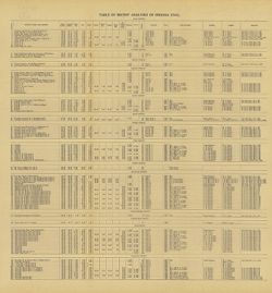
- Subject:
- Geographic Subject: Clay County (Ind.), Topical Subject: IGS Annual Reports, Topical Subject: Coal, Topical Subject: Mines and mineral resources, Geographic ...
- Creator:
- Ashley, Geo. H. (George Hall), 1866-1951
- Publisher:
- Indiana. Department of Geology and Natural Resources
- Date Created:
- 1909
- Identifier:
- VAC3073-M-00359
- Genre:
- Tables (Data) and Charts
- Related URL:
- Catalog URL: https://iucat.iu.edu/catalog/4022271
- Abstract:
- Detached from: The coal deposits of Indiana : a supplemental report to the one issued in 1898 / by Beorge H. Ashley. In Indiana Department of Geology and Nat...
- Call Number:
- QE109 .A2 1908 map p144
- Caption:
- Imprint: Indianapolis : 1909
- Physical Description:
- Dimensions: 40 x 38 cm
- Alternate Identifier:
- Title Control Number: 390726IP
- Persistent URL:
- https://purl.dlib.indiana.edu/iudl/images/VAC3073/VAC3073-M-00359
- Provenance:
- 33rd Annual Report (1908) / Indiana. Department of Geology and Natural Resources.
