Geographic Subject: Indiana, Topical Subject: Mineral industries, and Topical Subject: Mineral resources
Creator:
Smith, Ned M. (Ned Myron), Guennel, G. K., Patton, John B. (John Barratt), 1915-, Wayne, William J. (William John), 1922-, and Murray, Haydn H. (Haydn Herber...
Publisher:
Indiana. Geological Survey
Date Created:
1953
Identifier:
VAC3073-M-00645
Genre:
Thematic maps
Geographic Location:
Coordinates: W0880500 W0844700 N0414500 N0374600
Related URL:
Catalog URL: No Record at this time
Abstract:
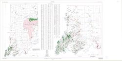
"Base from Map of Indiana, 1950 edition, published by U.S. Geological Survey. Minor revisions made from Indiana Dept. of Conservation, Geological Survey...
Call Number:
0.00E+00
Caption:
Imprint: [Bloomington, In.:] Indiana Department of Conservation, Geological Survey, 1953.
Physical Description:
Scale: 1:1,000,000 and Dimensions: 46 x 31 cm
Alternate Identifier:
Title Control Number: https://iucat.iu.edu/catalog/18571114 and Alternate ID: a18571114
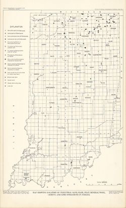
"Base from Map of Indiana, 1950 edition, published by U.S. Geological Survey. Minor revisions and additions made from Indiana Department of Conservation...
Call Number:
G4091.H5 1952 .M8
Caption:
Imprint: [Bloomington, Ind.?] : Indiana Department of Conservation, Geological Survey, 1952.
Geographic Subject: Indiana and Topical Subject: Coal mines and mining
Publisher:
Indiana. Geological Survey
Date Created:
2000
Identifier:
VAC3073-M-00283
Genre:
Geological maps
Related URL:
Catalog URL: https://iucat.iu.edu/catalog/4898390
Abstract:
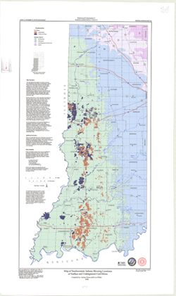
"Minde data compilation complete through October 1997." "All mine data shown on this map are recompiled by IGS personnel as part of the Co...
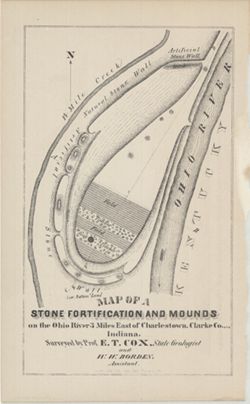
Surveyed by Prof. E. T. Cox and W. W. Borden. Pictorial map showing natural and artificial stone walls surrounding fields, timber, and mounds between the Ohi...
Call Number:
G4093.C4R4 1873 .C69
Caption:
Imprint: Indianapolis : Braden & Burford, Steam Lith., [1873] and Imprint: [Indianapolis] : [Geological Survey of Indiana], [1874]
Physical Description:
Dimensions: on sheet 22 x 14 cm and Scale: Scale not given.
Alternate Identifier:
Title Control Number: a18318556 and Alternate ID: 390723IP
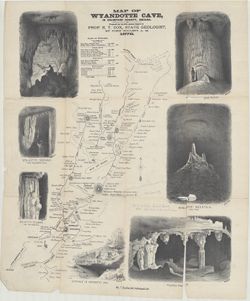
Prepared for the 10th Annual Report of Prof. E. T. Cox, State Geologist, by John Collett, A. M. Relief shown by hachures. Includes sketches of some cave feat...
Call Number:
G4093.C7C23 1878 .C6
Caption:
Imprint: [Indianapolis] : [Indianapolis Journal Company, State printers], [1879] and Imprint: [Indianapolis] : [Geological Survey of Indiana], [1879]
Physical Description:
Dimensions: on sheet 54 x 46 cm and Scale: Approximately 1:11,000
Alternate Identifier:
Alternate ID: 390723IP and Title Control Number: a18372653
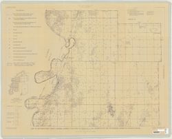
Relief shown by hachures. Shows cities and towns, operating and proposed railroads, prairies, test bores, deposits of iron ore and mill stone grit, mills, qu...
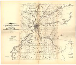
Compiled for the seventh annual report of E.T. Cox, State Geologist , geology by Prof. E.T. Cox, 1875. Shows cities and towns, railroads, coal seams and outc...
Call Number:
G4093.V5C5 1875 .C6
Caption:
Imprint: [Indianapolis] : [Sentinel Company, printers], [1876] and Imprint: [Indianapolis] : [Geological Survey of Indiana], [1876]
Physical Description:
Scale: Approximately 1:120,000 and Dimensions: on sheet 39 x 45 cm
Alternate Identifier:
Title Control Number: a18349323 and Alternate ID: 390723IP
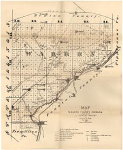
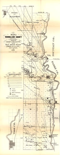
Drawn by John Collett for the 1st annual report of Prof. E.T. Cox, State Geologist, 1869 , lith. by W & J. Braden. Shows towns, railroads, coal, mills...
Call Number:
G4093.V4 1869 .C6
Caption:
Imprint: [Indianapolis] : [Alexander H. Conner, State Printer], [1869] and Imprint: [Indianapolis] : [Geological Survey of Indiana], [1869]
Physical Description:
Dimensions: on sheet 77 x 32 cm and Scale: Approximately 1:85,000. 3/4 of an inch to one mile
Alternate Identifier:
Title Control Number: a16799192 and Alternate ID: 390720IP