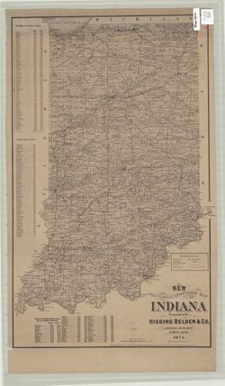
Geographic Subject: Indiana and Topical Subject: Administrative and political divisions
Creator:
Bourquin, D. L.
Publisher:
Higgins Beldin & Co.
Date Created:
1874
Identifier:
VAC3073-M-01284
Genre:
Maps
Geographic Location:
Coordinates: W0880700 W0844500 N0414500 N0375200
Related URL:
Catalog URL: https://iucat.iu.edu/catalog/4665301
Abstract:
D.L. Bourquin. Related name: Higgins, Belden & Company. Shows counties, townships, sections, county seats, other towns and post offices, rivers, an...
Call Number:
G4090 1874 .B68
Caption:
Imprint: Chicago : Higgins Beldin & Co., 1874.
Physical Description:
Scale: Approximately 1:760,320. 12 miles to the inch and Dimensions: 67 x 40 cm
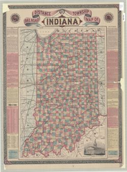
Geographic Subject: Indiana, Topical Subject: Railroads, and Topical Subject: Administrative and political divisions
Creator:
Bridgman, E. C.
Publisher:
Bridgman, E. C.
Date Created:
1871
Identifier:
VAC3073-M-01283
Genre:
Maps
Geographic Location:
Coordinates: W0880700 W0844500 N0414500 N0375200
Related URL:
Catalog URL: https://iucat.iu.edu/catalog/5052641
Abstract:
Shows railroads, counties, townships, cities, towns, and railroad stations. Includes "Description on Indiana", 1870 census figures for counties...
Call Number:
G4090 1871 .B75
Caption:
Imprint: New York : E.C. Bridgman, c1871.
Physical Description:
Dimensions: 69 x 46 cm and Scale: Approximately 1:675,000
Topical Subject: Administrative and political divisions and Geographic Subject: Indiana
Creator:
Mendenhall, Edward
Publisher:
Mendenhall, Edward
Date Created:
1854
Identifier:
VAC3073-M-01281
Genre:
Maps
Geographic Location:
Coordinates: W0880700 W0844500 N0414500 N0375200
Related URL:
Catalog URL: https://iucat.iu.edu/catalog/5176337
Abstract:
Cover title: Township map of Indiana Prime meridian: Washington. Folded in covers 15 x 10 cm. "Transfer'd from copper & printed from sto...
Call Number:
G4090 1854 .M46
Caption:
Imprint: Cincinnati, O. : E. Mendenhall, 1854.
Physical Description:
Scale: Approximately 1:1,013,760 and Dimensions: 46 x 33 cm
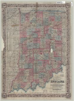
Topical Subject: Administrative and political divisions and Geographic Subject: Indiana
Creator:
Spears, Ed and Cram, George Franklin, 1841-1928
Publisher:
Western Map Depot
Date Created:
1875
Identifier:
VAC3073-M-01279
Genre:
Maps
Geographic Location:
Coordinates: W0880700 W0844500 N0414500 N0375200
Related URL:
Catalog URL: https://iucat.iu.edu/catalog/2801811
Abstract:
Variant title: New sectional map of Indiana Shows counties, townships, sections, cities and towns, and railroads. Includes text and census by counties. ...
Call Number:
G4090 1875 .C73
Caption:
Imprint: Chicago : Western Map Depot, 1875.
Physical Description:
Scale: Approximately 1:462,000 and Dimensions: 96 x 71 cm, on sheet 107 x 87 cm
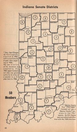
Topical Subject: Election districts, Topical Subject: Administrative and political divisions, Geographic Subject: Indiana, Topical Subject: Railroads, Topica...
Creator:
Colton, J. H. (Joseph Hutchins), 1800-1893
Publisher:
J.H. Colton & Co.
Date Created:
1854
Identifier:
VAC3073-M-01277
Genre:
Thematic maps
Geographic Location:
Coordinates: W0880700 W0844500 N0414500 N0375200
Related URL:
Catalog URL: https://iucat.iu.edu/catalog/7738188
Abstract:
"Entered according to act of Congress in the year 1852 ..." Also shows congressional districts. Includes inset tables "Statistics of populatio...
Call Number:
G4090 1854 .C6
Caption:
Imprint: New York : J.H. Colton, 1854
Physical Description:
Dimensions: 91 x 63 cm and Scale: Scale not given.
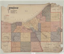
Geographic Subject: Indianapolis Metropolitan Area (Ind.), Topical Subject: Schools, Topical Subject: Administrative and political divisions, Geographic Subj...
Creator:
Palmer, Thos. W. (Thomas W.) and Carpenter, H. C.
Publisher:
Baker & Randolph
Date Created:
1889
Identifier:
VAC3073-M-01274
Genre:
Maps and Cadastral maps
Geographic Location:
Coordinates: W0860929 W0860929 N0394606 N0394606
Related URL:
Catalog URL: new.iucat.iu.edu/catalog/4665173
Abstract:
Surveyed and compiled from official records by H.C Carpenter , Thos. W. Palmer, draughtsman. Cadastral map showing landowners. Shows ward and school district...
Call Number:
G4094.I4G46 1889 .C37
Caption:
Imprint: Indianapolis : Baker & Randolph, [c1889]
Physical Description:
Scale: Approximately 1:7,150 and Dimensions: 159 x 206 cm, on sheets 89 x 57 cm or smaller
Shows Indiana election districts for the state's Senate with the number of senators for each district. Appears in Indiana almanac and fact book. Secon...
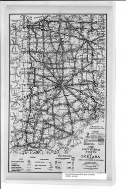
Caption title: Sub-district & road section map. Shows roads by surface and composition type as well as official highway markers, boundaries and headquart...
Call Number:
G4091.P2 1929 .I5
Caption:
Imprint: [Indianapolis] : [Wm. B. Burford, contractor for state printing and binding], [1930] and Imprint: [Indianapolis] : [The Legislative Bureau], [1930]
Physical Description:
Scale: Approximately 1:1,370,000 and Dimensions: 38 x 23 cm, on sheet 43 x 26 cm
Alternate Identifier:
Alternate ID: 397754IP and Title Control Number: a18455618


![A new map of Indiana [cartographic material] : exhibiting the counties, townships, cities, villages, and post offices, rail roads, canals, and common roads.](https://iiif.uits.iu.edu/iiif/2/rf560b15p%2Ffiles%2F277d357a-ee84-4cfa-987c-4c52a6d19c25/full/250,/0/default.jpg)
![Cram's new sectional map of Indiana [map] / complied and published by George F. Cram , drawn & engraved in the offices of Geo. F. Cram by Ed Spears.](https://iiif.uits.iu.edu/iiif/2/9306v2729%2Ffiles%2Ff383089b-1489-467d-80c2-3f33e7384298/full/250,/0/default.jpg)
![Map of the City of Indianapolis and its suburbs [map]](https://iiif.uits.iu.edu/iiif/2/v692v943f%2Ffiles%2Fcb6898c0-54f1-4245-b5e2-96cd8bf1b867/full/250,/0/default.jpg)