
Search Constraints
« Previous |
1 - 50 of 8,218
|
Next »
Search Results
-
- Subject:
- Entomologists and Wasps
- Creator:
- Kinsey, Alfred C. (Alfred Charles), 1894-1956
- Language:
- English
- Date Created:
- Circa 1931-1932
- Identifier:
- VAE1595-000004
- Geographic Location:
- Mexico and United States
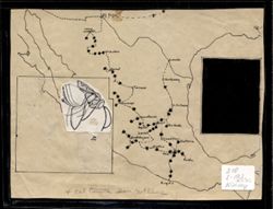
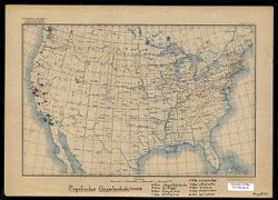
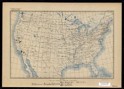
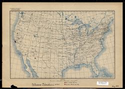
- Abstract:
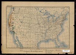
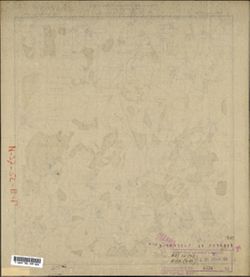
- Map created by Alfred C. Kinsey displaying route and data points associated with Kinsey's field research on gall wasps. On this map, data points, marked ...
- Call Number:
- 210 L-193 (1931-32) Kinsey
- Caption:
- The words "4 col tonite Don McClane" appear at the bottom center of the map. It is unclear at this time whether the words are related to the map co...
- Country:
- United States
- Persistent URL:
- http://purl.dlib.indiana.edu/iudl/images/VAE1595/VAE1595-000004
-
- Subject:
- Wasps and Entomologists
- Creator:
- Kinsey, Alfred C. (Alfred Charles), 1894-1956
- Language:
- English
- Date Created:
- Circa 1936-1937
- Identifier:
- VAE1595-000003
- Geographic Location:
- United States, Mexico, and Guatemala
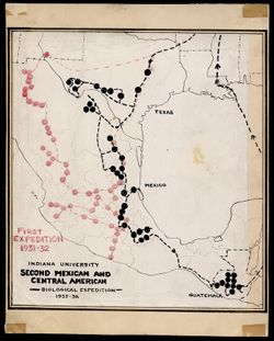
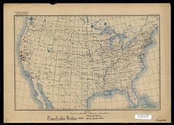
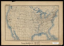
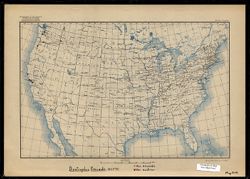
- Abstract:
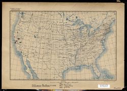
- Map created by Alfred C. Kinsey displaying routes and data points associated with Kinsey's field research on gall wasps. On this map, Second Expedition d...
- Country:
- United States
- Persistent URL:
- http://purl.dlib.indiana.edu/iudl/images/VAE1595/VAE1595-000003
-
- Subject:
- Entomologists and Wasps
- Creator:
- Kinsey, Alfred C. (Alfred Charles), 1894-1956
- Language:
- Latin and English
- Date Created:
- Circa 1917-1937
- Identifier:
- VAE1595-000006
- Geographic Location:
- United States and Canada
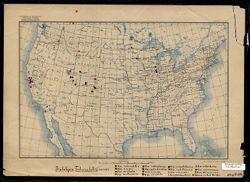
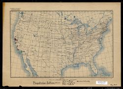
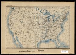
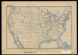
- Abstract:
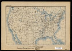
- One of a series of maps created or annotated by Alfred C. Kinsey, Most contain gall wasp data. Several only contain data on other types of flora and fauna. O...
- Caption:
- Var. tuberculatrix, Var. similis, Var. arefacta, Var. multispinosa, Var. coloradensis, Var. subcoloradesis [sic], Var. tumida, Var. xerophila, Var. wasatchen...
- Country:
- United States
- Physical Description:
- Base map type 1 (USGS. Edition of May 1906, reprinted 1922.) Map scale indicated in both graphic representation and representative fraction., Print Size: 7.5...
- Alternate Identifier:
- Map B28
- Persistent URL:
- http://purl.dlib.indiana.edu/iudl/images/VAE1595/VAE1595-000006
-
- Subject:
- Trees and Entomologists
- Creator:
- Kinsey, Alfred C. (Alfred Charles), 1894-1956
- Language:
- English
- Date Created:
- Circa 1917-1937
- Identifier:
- VAE1595-000005
- Geographic Location:
- Canada, United States, and Mexico
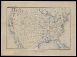
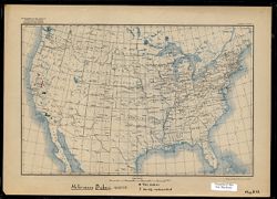
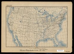
- Abstract:
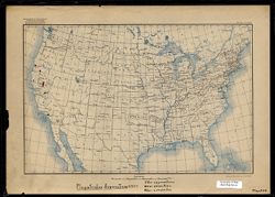
- One of a series of maps created or annotated by Alfred C. Kinsey. Most contain gall wasp data. Several only contain data on other types of flora and fauna. T...
- Country:
- United States
- Physical Description:
- Print Size: 7.5 x 11.5, Base map type 2 (USGS. Edition of Mar. 1911, reprinted 1923). Map scale indicated in graphic representation only., and Scale: Approxi...
- Persistent URL:
- http://purl.dlib.indiana.edu/iudl/images/VAE1595/VAE1595-000005
-
- Subject:
- Reptiles and Entomologists
- Creator:
- Kinsey, Alfred C. (Alfred Charles), 1894-1956
- Language:
- English and Latin
- Date Created:
- Circa 1917-1937
- Identifier:
- VAE1595-000008
- Geographic Location:
- United States and Mexico
- Abstract:
- One of a series of maps created or annotated by Alfred C. Kinsey. Most contain gall wasp data. Several only contain data on other types of flora and fauna. O...
- Caption:
- Var. occidentalis, Var. biseriatus, Var. taylori, Var. Beckii. This map is torn in several places on the bottom edge. One tear obscures the end of a handwrit...
- Country:
- United States
- Physical Description:
- Base map type 1 (USGS. Edition of May 1906, reprinted 1922.) Map scale indicated in both graphic representation and representative fraction., Scale: 1:11,875...
- Alternate Identifier:
- Map D2
- Persistent URL:
- http://purl.dlib.indiana.edu/iudl/images/VAE1595/VAE1595-000008
-
![Pituophis Catenife[r] Blainville](https://iiif.uits.iu.edu/iiif/2/7w62gm576%2Ffiles%2F173c48ee-315d-4457-a1b8-f492d0eedbb1/full/250,/0/default.jpg)
- Subject:
- Snakes and Entomologists
- Creator:
- Kinsey, Alfred C. (Alfred Charles), 1894-1956
- Language:
- Latin and English
- Date Created:
- 1917-1937
- Identifier:
- VAE1595-000007
- Geographic Location:
- United States and Mexico
- Abstract:
- One of a series of maps created or annotated by Alfred C. Kinsey. Most contain gall wasp data. Several only contain data on other types of flora and fauna. O...
- Caption:
- catenifer, heermanni, annectens, stejnegeri, deserticola, rutilus, ?? determination uncertain, possibly deserticola.
- Country:
- United States
- Physical Description:
- Scale: 1:11,875,000, Print Size: 7.5 x 11.5, and Base map type 1 (USGS. Edition of May 1906, reprinted 1922.) Map scale indicated in both graphic representat...
- Alternate Identifier:
- Map D1
- Persistent URL:
- http://purl.dlib.indiana.edu/iudl/images/VAE1595/VAE1595-000007
-
- Subject:
- Entomologists and Wasps
- Creator:
- Kinsey, Alfred C. (Alfred Charles), 1894-1956
- Language:
- English and Latin
- Date Created:
- Circa 1917-1937
- Identifier:
- VAE1595-000009
- Geographic Location:
- United States
- Abstract:
- One of a series of maps created or annotated by Alfred C. Kinsey. Most contain gall wasp data. Several only contain data on other types of flora and fauna. O...
- Caption:
- Var. pacificus, Var. subpacificus, Var. gracilis
- Country:
- United States
- Physical Description:
- Base map type 1 (USGS. Edition of May 1906, reprinted 1922.) Map scale indicated in both graphic representation and representative fraction., Print Size: 7.5...
- Alternate Identifier:
- Map B22
- Persistent URL:
- http://purl.dlib.indiana.edu/iudl/images/VAE1595/VAE1595-000009
-
- Subject:
- Entomologists and Wasps
- Creator:
- Kinsey, Alfred C. (Alfred Charles), 1894-1956
- Language:
- Latin and English
- Date Created:
- Circa 1917-1937
- Identifier:
- VAE1595-000010
- Geographic Location:
- United States
- Abstract:
- One of a series of maps created or annotated by Alfred C. Kinsey. Most contain gall wasp data. Several only contain data on other types of flora and fauna. O...
- Caption:
- Var. sanctae-clarae, Var. fuscior, Var. aliud
- Country:
- United States
- Physical Description:
- Scale: 1:11,875,000, Base map type 1 (USGS. Edition of May 1906, reprinted 1922.) Map scale indicated in both graphic representation and representative fract...
- Alternate Identifier:
- Map B23
- Persistent URL:
- http://purl.dlib.indiana.edu/iudl/images/VAE1595/VAE1595-000010
-
- Subject:
- Wasps and Entomologists
- Creator:
- Kinsey, Alfred C. (Alfred Charles), 1894-1956
- Language:
- Latin and English
- Date Created:
- Circa 1917-1937
- Identifier:
- VAE1595-000011
- Geographic Location:
- United States
- Abstract:
- One of a series of maps created or annotated by Alfred C. Kinsey. Most contain gall wasp data. Several only contain data on other types of flora and fauna. O...
- Caption:
- Var. asymmetricus, Var. annectens, Var. compactus
- Country:
- United States
- Physical Description:
- Print Size: 7.5 x 11.5, Base map type 1 (USGS. Edition of May 1906, reprinted 1922.) Map scale indicated in both graphic representation and representative fr...
- Alternate Identifier:
- Map B24
- Persistent URL:
- http://purl.dlib.indiana.edu/iudl/images/VAE1595/VAE1595-000011
-
- Subject:
- Entomologists and Wasps
- Creator:
- Kinsey, Alfred C. (Alfred Charles), 1894-1956
- Language:
- English and Latin
- Date Created:
- Circa 1917-1937
- Identifier:
- VAE1595-000012
- Geographic Location:
- United States
- Abstract:
- One of a series of maps created or annotated by Alfred C. Kinsey. Most contain gall wasp data. Several only contain data on other types of flora and fauna. O...
- Caption:
- Var. chrysolepidicola, Var. kelloggi, Var. diminuens, Var. alutaceus, Var. compositus, Var atricinctus, Var. pugnus, Var. pugnoides, Var. garryanae
- Country:
- United States
- Physical Description:
- Print Size: 7.5 x 11.5, Scale: 1:11,875,000, and Base map type 1 (USGS. Edition of May 1906, reprinted 1922.) Map scale indicated in both graphic representat...
- Alternate Identifier:
- Map B25
- Persistent URL:
- http://purl.dlib.indiana.edu/iudl/images/VAE1595/VAE1595-000012
-
- Subject:
- Entomologists and Wasps
- Creator:
- Kinsey, Alfred C. (Alfred Charles), 1894-1956
- Language:
- English and Latin
- Date Created:
- Circa 1917-1937
- Identifier:
- VAE1595-000013
- Geographic Location:
- United States
- Abstract:
- One of a series of maps created or annotated by Alfred C. Kinsey. Most contain gall wasp data. Several only contain data on other types of flora and fauna. O...
- Caption:
- Var. perdens, Var. destructor
- Country:
- United States
- Physical Description:
- Print Size: 7.5 x 11.5, Base map type 1 (USGS. Edition of May 1906, reprinted 1922.) Map scale indicated in both graphic representation and representative fr...
- Alternate Identifier:
- Map B26
- Persistent URL:
- http://purl.dlib.indiana.edu/iudl/images/VAE1595/VAE1595-000013
-
- Subject:
- Wasps and Entomologists
- Creator:
- Kinsey, Alfred C. (Alfred Charles), 1894-1956
- Language:
- English and Latin
- Date Created:
- Circa 1917-1937
- Identifier:
- VAE1595-000014
- Geographic Location:
- United States
- Abstract:
- One of a series of maps created or annotated by Alfred C. Kinsey. Most contain gall wasp data. Several only contain data on other types of flora and fauna. O...
- Caption:
- Var. suttonii, Var. polythyra, Var. lustrior, undescribed variety
- Country:
- United States
- Physical Description:
- Base map type 1 (USGS. Edition of May 1906, reprinted 1922.) Map scale indicated in both graphic representation and representative fraction., Print Size: 7.5...
- Alternate Identifier:
- Map B27
- Persistent URL:
- http://purl.dlib.indiana.edu/iudl/images/VAE1595/VAE1595-000014
-
- Subject:
- Wasps and Entomologists
- Creator:
- Kinsey, Alfred C. (Alfred Charles), 1894-1956
- Language:
- English and Latin
- Date Created:
- Circa 1917-1937
- Identifier:
- VAE1595-000015
- Geographic Location:
- United States
- Abstract:
- One of a series of maps created or annotated by Alfred C. Kinsey. Most contain gall wasp data. Several only contain data on other types of flora and fauna. O...
- Caption:
- Var. bakeri, Variety undescribed
- Country:
- United States
- Physical Description:
- Base map type 1 (USGS. Edition of May 1906, reprinted 1922.) Map scale indicated in both graphic representation and representative fraction., Scale: 1:11,875...
- Alternate Identifier:
- Map B18
- Persistent URL:
- http://purl.dlib.indiana.edu/iudl/images/VAE1595/VAE1595-000015
-
- Subject:
- Entomologists and Wasps
- Creator:
- Kinsey, Alfred C. (Alfred Charles), 1894-1956
- Language:
- English and Latin
- Date Created:
- Circa 1917-1937
- Identifier:
- VAE1595-000016
- Geographic Location:
- United States
- Abstract:
- One of a series of maps created or annotated by Alfred C. Kinsey. Most contain gall wasp data. Several only contain data on other types of flora and fauna. O...
- Caption:
- Var. dasydaclyli [sic], Var. eriophorus, Var. pygmaeus, Var. medius
- Country:
- United States
- Physical Description:
- Scale: 1:11,875,000, Print Size: 7.5 x 11.5, and Base map type 1 (USGS. Edition of May 1906, reprinted 1922.) Map scale indicated in both graphic representat...
- Alternate Identifier:
- Map B19
- Persistent URL:
- http://purl.dlib.indiana.edu/iudl/images/VAE1595/VAE1595-000016
-
- Subject:
- Entomologists and Wasps
- Creator:
- Kinsey, Alfred C. (Alfred Charles), 1894-1956
- Language:
- English and Latin
- Date Created:
- Circa 1917-1937
- Identifier:
- VAE1595-000019
- Geographic Location:
- United States
- Abstract:
- One of a series of maps created or annotated by Alfred C. Kinsey. Most contain gall wasp data. Several only contain data on other types of flora and fauna. O...
- Caption:
- Var. spectabilis, Var. incisus, Var. ukiahensis, Variety has not been determined.
- Country:
- United States
- Physical Description:
- Scale: 1:11,875,000, Print Size: 7.5 x 11.5, and Base map type 1 (USGS. Edition of May 1906, reprinted 1922.) Map scale indicated in both graphic representat...
- Alternate Identifier:
- Map B11
- Persistent URL:
- http://purl.dlib.indiana.edu/iudl/images/VAE1595/VAE1595-000019
-
- Subject:
- Entomologists and Wasps
- Creator:
- Kinsey, Alfred C. (Alfred Charles), 1894-1956
- Language:
- English and Latin
- Date Created:
- Circa 1917-1937
- Identifier:
- VAE1595-000020
- Geographic Location:
- United States
- Abstract:
- One of a series of maps created or annotated by Alfred C. Kinsey. Most contain gall wasp data. Several only contain data on other types of flora and fauna. O...
- Caption:
- Var. brunneus, Var. atrior
- Country:
- United States
- Physical Description:
- Base map type 1 (USGS. Edition of May 1906, reprinted 1922.) Map scale indicated in both graphic representation and representative fraction., Print Size: 7.5...
- Alternate Identifier:
- Map B12
- Persistent URL:
- http://purl.dlib.indiana.edu/iudl/images/VAE1595/VAE1595-000020
-
- Subject:
- Wasps and Entomologists
- Creator:
- Kinsey, Alfred C. (Alfred Charles), 1894-1956
- Language:
- English and Latin
- Date Created:
- Circa 1917-1937
- Identifier:
- VAE1595-000017
- Geographic Location:
- United States
- Abstract:
- One of a series of maps created or annotated by Alfred C. Kinsey. Most contain gall wasp data. Several only contain data on other types of flora and fauna. O...
- Caption:
- Var. chrysolepidis, Var. malus
- Country:
- United States
- Physical Description:
- Base map type 1 (USGS. Edition of May 1906, reprinted 1922.) Map scale indicated in both graphic representation and representative fraction., Print Size: 7.5...
- Alternate Identifier:
- Map B20
- Persistent URL:
- http://purl.dlib.indiana.edu/iudl/images/VAE1595/VAE1595-000017
-
- Subject:
- Entomologists and Wasps
- Creator:
- Kinsey, Alfred C. (Alfred Charles), 1894-1956
- Language:
- Latin and English
- Date Created:
- Circa 1917-1937
- Identifier:
- VAE1595-000018
- Geographic Location:
- United States
- Abstract:
- One of a series of maps created or annotated by Alfred C. Kinsey. Most contain gall wasp data. Several only contain data on other types of flora and fauna. O...
- Caption:
- Var. melanoderma, Undescribed variety
- Country:
- United States
- Physical Description:
- Print Size: 7.5 x 11.5, Base map type 1 (USGS. Edition of May 1906, reprinted 1922.) Map scale indicated in both graphic representation and representative fr...
- Alternate Identifier:
- Map B21
- Persistent URL:
- http://purl.dlib.indiana.edu/iudl/images/VAE1595/VAE1595-000018
-
- Subject:
- Wasps and Entomologists
- Creator:
- Kinsey, Alfred C. (Alfred Charles), 1894-1956
- Language:
- English and Latin
- Date Created:
- Circa 1917-1937
- Identifier:
- VAE1595-000022
- Geographic Location:
- United States
- Abstract:
- One of a series of maps created or annotated by Alfred C. Kinsey. Most contain gall wasp data. Several only contain data on other types of flora and fauna. O...
- Caption:
- Var. kincaidii, Var. austrior
- Country:
- United States
- Physical Description:
- Print Size: 7.5 x 11.5, Scale: 1:11,875,000, and Base map type 1 (USGS. Edition of May 1906, reprinted 1922.) Map scale indicated in both graphic representat...
- Alternate Identifier:
- Map B14
- Persistent URL:
- http://purl.dlib.indiana.edu/iudl/images/VAE1595/VAE1595-000022
-
- Subject:
- Entomologists and Wasps
- Creator:
- Kinsey, Alfred C. (Alfred Charles), 1894-1956
- Language:
- Latin and English
- Date Created:
- Circa 1917-1937
- Identifier:
- VAE1595-000021
- Geographic Location:
- United States
- Abstract:
- One of a series of maps created or annotated by Alfred C. Kinsey. Most contain gall wasp data. Several only contain data on other types of flora and fauna. O...
- Country:
- United States
- Physical Description:
- Scale: 1:11,875,000, Print Size: 7.5 x 11.5, and Base map type 1 (USGS. Edition of May 1906, reprinted 1922.) Map scale indicated in both graphic representat...
- Alternate Identifier:
- Map B13
- Persistent URL:
- http://purl.dlib.indiana.edu/iudl/images/VAE1595/VAE1595-000021
-
- Description:
- 1938
- Subject:
- Topical Subject: Soviet Union, Topical Subject: Maps, and Geographic Subject: Gorshkovo
- Publisher:
- Главное Управление Геодезии и Картографии при СНК СССР
- Language:
- Russian
- Date Created:
- 1941
- Identifier:
- VAC9619-001600
- Genre:
- Military Maps and Topographic Maps
- Geographic Location:
- Coordinates: 54.3333, 37.75, 54.5, 38
- Related URL:
- Download GeoTIFF: https://drive.google.com/open?id=1n5OJOuYUDbObh4psLn6H0cDRB7jPil10 and Catalog URL: http://iucat.iu.edu/catalog/5020131
- Abstract:
- Modern area represented: Gorshkovo, Tula oblast, Russia
- Call Number:
- G7000 s50 .S68 sheet N-37-52-Г
- City:
- Горшково (Gorshkovo)
- Copyright Holder:
- No Copyright - United States
- Country:
- СССР (USSR)
- State/Province:
- РСФСР (RSFSR) and Тульская область (Tula oblast)
- Physical Description:
- Scale: 1:50,000
- Persistent URL:
- http://purl.dlib.indiana.edu/iudl/images/VAC9619/VAC9619-001600
- Provenance:
- DMA Topographic Center, Army Map Service Library, OMAHA, Library of Congress Geography & Map Division
-
- Description:
- 1853
- Subject:
- Geographic Subject: Laptevo, Topical Subject: Soviet Union, and Topical Subject: Maps
- Publisher:
- Управление военных топографов
- Language:
- Russian
- Date Created:
- 1930
- Identifier:
- VAC9619-001599
- Genre:
- Topographic Maps and Military Maps
- Geographic Location:
- Coordinates: 54.333, 37.573, 54.5, 37.823
- Related URL:
- Catalog URL: http://iucat.iu.edu/catalog/5020131 and Download GeoTIFF: https://drive.google.com/file/d/1aGuqwqLIQb2dh7zU2_a7HtzP9CLQ1XqP/view?usp=sharing
- Abstract:
- Modern area represented: Laptevo, Tula oblast, Russia
- Call Number:
- G7000 s50 .S68 sheet N-37-52-В/Г
- City:
- Ст. Лаптево (Laptevo)
- Copyright Holder:
- No Copyright - United States
- Country:
- СССР (USSR)
- State/Province:
- Московская область (Moscow oblast) and РСФСР (RSFSR)
- Physical Description:
- Scale: 1:50,000
- Persistent URL:
- http://purl.dlib.indiana.edu/iudl/images/VAC9619/VAC9619-001599
- Provenance:
- Army Map Service Library, Library of Congress Geography & Map Division, OMAHA
-
- Description:
- 1938
- Subject:
- Topical Subject: Maps, Geographic Subject: Laptevo, and Topical Subject: Soviet Union
- Publisher:
- Главное Управление Геодезии и Картографии при СНК СССР
- Language:
- Russian
- Date Created:
- 1941
- Identifier:
- VAC9619-001598
- Genre:
- Military Maps and Topographic Maps
- Geographic Location:
- Coordinates: 54.3333, 37.5, 54.5, 37.75
- Related URL:
- Download GeoTIFF: https://drive.google.com/open?id=1jVqSWj3avGDHX-ZeBo8XOwnk6HPHPUR3 and Catalog URL: http://iucat.iu.edu/catalog/5020131
- Abstract:
- Moder area represented: Laptevo, Tula oblast, Russia
- Call Number:
- G7000 s50 .S68 sheet N-37-52-B
- City:
- Лаптево (Laptevo)
- Copyright Holder:
- No Copyright - United States
- Country:
- СССР (USSR)
- State/Province:
- Тульская область (Tula oblast) and РСФСР (RSFSR)
- Physical Description:
- Scale: 1:50,000
- Persistent URL:
- http://purl.dlib.indiana.edu/iudl/images/VAC9619/VAC9619-001598
- Provenance:
- DMA Topographic Center, Army Map Service Library, OMAHA, Library of Congress Geography & Map Division
-
- Description:
- 1938
- Subject:
- Topical Subject: Maps, Geographic Subject: Mokraya Kor, and Topical Subject: Soviet Union
- Publisher:
- Главное Управление Геодезии и Картографии при СНК СССР
- Language:
- Russian
- Date Created:
- 1941
- Identifier:
- VAC9619-001597
- Genre:
- Military Maps and Topographic Maps
- Geographic Location:
- Coordinates: 54.5, 37.75, 54.6667, 38
- Related URL:
- Download GeoTIFF: https://drive.google.com/open?id=1gffQELAjTu3MBlbTHyYP8PMSKwWWqeE2 and Catalog URL: http://iucat.iu.edu/catalog/5020131
- Abstract:
- Modern area represented: Mokraya Kor, Tula oblast, Russia
- Call Number:
- G7000 s50 .S68 sheet N-37-52-B
- City:
- Мокрая Корь (Mokraya Kor)
- Copyright Holder:
- No Copyright - United States
- Country:
- СССР (USSR)
- State/Province:
- Тульская область (Tula oblast) and РСФСР (RSFSR)
- Physical Description:
- Scale: 1:50,000
- Persistent URL:
- http://purl.dlib.indiana.edu/iudl/images/VAC9619/VAC9619-001597
- Provenance:
- DMA Topographic Center, Army Map Service Library, OMAHA, Library of Congress Geography & Map Division
-
- Description:
- 1938
- Subject:
- Geographic Subject: Nikiforovo, Topical Subject: Maps, and Topical Subject: Soviet Union
- Publisher:
- Главное Управление Геодезии и Картографии при СНК СССР
- Language:
- Russian
- Date Created:
- 1941
- Identifier:
- VAC9619-001596
- Genre:
- Topographic Maps and Military Maps
- Geographic Location:
- Coordinates: 54.833, 37.5, 55, 37.75
- Related URL:
- Catalog URL: http://iucat.iu.edu/catalog/5020131 and Download GeoTIFF: https://drive.google.com/open?id=1El5NA8PIkjw7gec-UlLvip8MP0uFlYEF
- Abstract:
- Modern area represented: Nikiforovo, Moscow oblast, Russia
- Call Number:
- G7000 s50 .S68 sheet N-37-40-A
- City:
- Никифорово (Nikiforovo)
- Copyright Holder:
- No Copyright - United States
- Country:
- СССР (USSR)
- State/Province:
- РСФСР (RSFSR), Московская область (Moscow oblast), and Тульская область (Tula oblast)
- Physical Description:
- Scale: 1:50,000
- Persistent URL:
- http://purl.dlib.indiana.edu/iudl/images/VAC9619/VAC9619-001596
- Provenance:
- DMA Topographic Center, Army Map Service Library, OMAHA, Library of Congress Geography & Map Division
-
- Description:
- 1939
- Subject:
- Topical Subject: Soviet Union, Geographic Subject: Novoye Titovo, and Topical Subject: Maps
- Publisher:
- Главное Управление Геодезии и Картографии при СНК СССР
- Language:
- Russian
- Date Created:
- 1941
- Identifier:
- VAC9619-001595
- Genre:
- Topographic Maps and Military Maps
- Geographic Location:
- Coordinates: 55.5, 39, 55.6667, 39.25
- Related URL:
- Catalog URL: http://iucat.iu.edu/catalog/5020131 and Download GeoTIFF: https://drive.google.com/open?id=15wtPDAMzRpWlDqIsKsp-80h3KG7fUqbB
- Abstract:
- Modern area represented: Novoye Titovo, Moscow oblast, Russia
- Call Number:
- G7000 s50 .S68 sheet N-37-19-A
- Copyright Holder:
- No Copyright - United States
- Country:
- СССР (USSR)
- State/Province:
- Московская область (Moscow oblast) and РСФСР (RSFSR)
- Physical Description:
- Scale: 1:50,000
- Persistent URL:
- http://purl.dlib.indiana.edu/iudl/images/VAC9619/VAC9619-001595
- Provenance:
- Army Map Service Library, Library of Congress Geography & Map Division, OMAHA
-
- Description:
- 1926
- Subject:
- Topical Subject: Maps, Geographic Subject: Ilyinsky Pogost, and Topical Subject: Soviet Union
- Publisher:
- Главный Геодезический Комитет
- Language:
- Russian
- Identifier:
- VAC9619-001594
- Genre:
- Military Maps and Topographic Maps
- Geographic Location:
- Coordinates: 55.3333, 38.75, 55.5, 39
- Related URL:
- Download GeoTIFF: https://drive.google.com/open?id=1UmQ-GGS9hBMKjr1ZyiAC9Gg6-BTnRgIE and Catalog URL: http://iucat.iu.edu/catalog/5020131
- Abstract:
- Modern area represented: Ilyinsky Pogost, Moscow oblast, Russia
- Call Number:
- G7000 s50 .S68 sheet N-37-18-Г
- City:
- Ильинский Погост (Ilinskiy Pogost)
- Copyright Holder:
- No Copyright - United States
- Country:
- СССР (USSR)
- State/Province:
- РСФСР (RSFSR) and Московская область (Moscow oblast)
- Physical Description:
- Scale: 1:50,000
- Persistent URL:
- http://purl.dlib.indiana.edu/iudl/images/VAC9619/VAC9619-001594
- Provenance:
- Army Map Service Library, Library of Congress Geography & Map Division, OMAHA
-
- Description:
- 1927
- Subject:
- Geographic Subject: Kurovskoye, Topical Subject: Soviet Union, and Topical Subject: Maps
- Publisher:
- Главный Геодезический Комитет
- Language:
- Russian
- Identifier:
- VAC9619-001592
- Genre:
- Topographic Maps and Military Maps
- Geographic Location:
- Coordinates: 55.5, 38.75, 55.6667, 39
- Related URL:
- Download GeoTIFF: https://drive.google.com/open?id=1PCPLpNhalxc-K3di2FF8ZgGX5bcUdweA and Catalog URL: http://iucat.iu.edu/catalog/5020131
- Abstract:
- Modern area represented: Kurovskoye, Moscow oblast, Russia
- Call Number:
- G7000 s50 .S68 sheet N-37-18-Б
- City:
- Куровская (Kurovskaya)
- Copyright Holder:
- No Copyright - United States
- Country:
- СССР (USSR)
- State/Province:
- Московская область (Moscow oblast) and РСФСР (RSFSR)
- Physical Description:
- Scale: 1:50,000
- Persistent URL:
- http://purl.dlib.indiana.edu/iudl/images/VAC9619/VAC9619-001592
- Provenance:
- DMA Topographic Center, Army Map Service Library, OMAHA, Library of Congress Geography & Map Division
-
- Description:
- 1926
- Subject:
- Topical Subject: Soviet Union, Topical Subject: Maps, and Geographic Subject: Konobeyevo
- Publisher:
- Главный Геодезический Комитет
- Language:
- Russian
- Identifier:
- VAC9619-001593
- Genre:
- Topographic Maps and Military Maps
- Geographic Location:
- Coordinates: 55.3333, 38.5, 55.5, 38.75
- Related URL:
- Catalog URL: http://iucat.iu.edu/catalog/5020131 and Download GeoTIFF: https://drive.google.com/open?id=1n_4NvNZ74yltpHy3SigmaZbvsD15D76K
- Abstract:
- Modern area represented: Konobeyevo, Moscow oblast, Russia
- Call Number:
- G7000 s50 .S68 sheet N-37-18-B
- City:
- Конобеево (Konobeyevo)
- Copyright Holder:
- No Copyright - United States
- Country:
- СССР (USSR)
- State/Province:
- Московская область (Moscow oblast) and РСФСР (RSFSR)
- Physical Description:
- Scale: 1:50,000
- Persistent URL:
- http://purl.dlib.indiana.edu/iudl/images/VAC9619/VAC9619-001593
- Provenance:
- DMA Topographic Center, Army Map Service Library, Library of Congress Geography & Map Division
-
- Description:
- 1883
- Subject:
- Geographic Subject: Târgu Ocna, Topical Subject: Soviet Union, and Topical Subject: Maps
- Publisher:
- Генеральный штаб РККА
- Language:
- Russian
- Date Created:
- 1901
- Identifier:
- VAC9619-001591
- Genre:
- Topographic Maps and Military Maps
- Geographic Location:
- Coordinates: 46, 26.5, 46.3333, 27
- Related URL:
- Catalog URL: https://iucat.iu.edu/catalog/5020129 and Download GeoTIFF: https://drive.google.com/open?id=10x2oiAscdChrKJVEN93a3hEPHjpl_70K
- Abstract:
- Modern area represented: Târgu Ocna, Bacău county, Romania
- Call Number:
- G7000 s100 .S7 sheet L-35-66
- City:
- Тыргул Окна (Târgu Ocna)
- Copyright Holder:
- No Copyright - United States
- Country:
- Румыния (Romania)
- Physical Description:
- Scale: 1:100,000
- Persistent URL:
- http://purl.dlib.indiana.edu/iudl/images/VAC9619/VAC9619-001591
- Provenance:
- CIA Map Library, Atlasblatt
-
- Description:
- 1938
- Subject:
- Geographic Subject: Vereya, Topical Subject: Soviet Union, and Topical Subject: Maps
- Publisher:
- Главное Управление Геодезии и Картографии при СНК СССР
- Language:
- Russian
- Date Created:
- 1941
- Identifier:
- VAC9619-001590
- Genre:
- Topographic Maps and Military Maps
- Geographic Location:
- Coordinates: 55.3333, 36, 55.5, 36.25
- Related URL:
- Download GeoTIFF: https://drive.google.com/open?id=1wBMla9XTlKS1xoCxrPqhKu9J0XdbhkEc and Catalog URL: http://iucat.iu.edu/catalog/5020131
- Abstract:
- Modern area represented: Vereya, Moscow oblast, Russia
- Call Number:
- G7000 s50 .S68 sheet N-37-13-C
- Copyright Holder:
- No Copyright - United States
- Country:
- СССР (USSR)
- State/Province:
- РСФСР (RSFSR) and Московская область (Moscow oblast)
- Physical Description:
- Scale: 1:50,000
- Persistent URL:
- http://purl.dlib.indiana.edu/iudl/images/VAC9619/VAC9619-001590
- Provenance:
- DMA Topographic Center, Army Map Service Library, OMAHA, Library of Congress Geography & Map Division
-
- Description:
- 1938
- Subject:
- Topical Subject: Maps, Topical Subject: Soviet Union, and Geographic Subject: Dorokhovo
- Publisher:
- Главное Управление Геодезии и Картографии при СНК СССР
- Language:
- Russian
- Date Created:
- 1941
- Identifier:
- VAC9619-001589
- Genre:
- Topographic Maps and Military Maps
- Geographic Location:
- Coordinates: 55.5, 36.25, 55.6667, 36.5
- Related URL:
- Catalog URL: http://iucat.iu.edu/catalog/5020131 and Download GeoTIFF: https://drive.google.com/open?id=1ae8VatKg7mKS3Ot_8Hz2EdxDA5_NzAMs
- Abstract:
- Modern area represented: Dorokhovo, Moscow oblast, Russia
- Call Number:
- G7000 s50 .S68 sheet N-37-13-Б
- City:
- Дорохово (Dorokhovo)
- Copyright Holder:
- No Copyright - United States
- Country:
- СССР (USSR)
- State/Province:
- РСФСР (RSFSR) and Московская область (Moscow oblast)
- Physical Description:
- Scale: 1:50,000
- Persistent URL:
- http://purl.dlib.indiana.edu/iudl/images/VAC9619/VAC9619-001589
- Provenance:
- DMA Topographic Center, Army Map Service Library, OMAHA, Library of Congress Geography & Map Division
-
- Description:
- 1938
- Subject:
- Geographic Subject: Mozhaysk, Topical Subject: Soviet Union, and Topical Subject: Maps
- Publisher:
- Главное Управление Геодезии и Картографии при СНК СССР
- Language:
- Russian
- Date Created:
- 1941
- Identifier:
- VAC9619-001588
- Genre:
- Topographic Maps and Military Maps
- Geographic Location:
- Coordinates: 55.5, 36, 55.667, 36.25
- Related URL:
- Catalog URL: http://iucat.iu.edu/catalog/5020131 and Download GeoTIFF: https://drive.google.com/open?id=16nonxp3OQjYiALBOGxIINLA42ZbyRq_9
- Abstract:
- Modern area represented: Mozhaysk, Moscow oblast, Russia
- Call Number:
- G7000 s50 .S68 sheet N-37-13-A
- Copyright Holder:
- No Copyright - United States
- Country:
- СССР (USSR)
- State/Province:
- Московская область (Moscow oblast) and РСФСР (RSFSR)
- Physical Description:
- Scale: 1:50,000
- Persistent URL:
- http://purl.dlib.indiana.edu/iudl/images/VAC9619/VAC9619-001588
- Provenance:
- Library of Congress Geography & Map Division
-
- Description:
- 1922
- Subject:
- Topical Subject: Maps, Topical Subject: Soviet Union, and Geographic Subject: Orekhovo-Zuyevo
- Publisher:
- Геодезический комитет ВСНХ-СССР
- Language:
- Russian
- Date Created:
- 1925
- Identifier:
- VAC9619-001587
- Genre:
- Topographic Maps and Military Maps
- Geographic Location:
- Coordinates: 55.6667, 38.75, 55.8333, 39
- Related URL:
- Catalog URL: http://iucat.iu.edu/catalog/5020131 and Download GeoTIFF: https://drive.google.com/open?id=1YSoC4qULp6BdN-5c-DqfZ7rEYz_wNjk4
- Abstract:
- Modern area represented: Orekhovo-Zuyevo, Moscow oblast, Russia
- Call Number:
- G7000 s50 .S68 sheet N-37-6-Г
- City:
- Орехово-Зуево (Orekhovo-Zuyevo)
- Copyright Holder:
- No Copyright - United States
- Country:
- СССР (USSR)
- State/Province:
- Московская область (Moscow oblast) and РСФСР (RSFSR)
- Physical Description:
- Scale: 1:50,000
- Persistent URL:
- http://purl.dlib.indiana.edu/iudl/images/VAC9619/VAC9619-001587
- Provenance:
- DMA Topographic Center, Army Map Service Library, OMAHA, Library of Congress Geography & Map Division
-
- Description:
- 1922
- Subject:
- Topical Subject: Soviet Union, Topical Subject: Maps, and Geographic Subject: Mytishchi
- Publisher:
- Управление военных топографов
- Language:
- Russian
- Date Created:
- 1929
- Identifier:
- VAC9619-001586
- Genre:
- Military Maps and Topographic Maps
- Geographic Location:
- Coordinates: 55.8667, 37.75, 56, 38
- Related URL:
- Catalog URL: http://iucat.iu.edu/catalog/5020131 and Download GeoTIFF: https://drive.google.com/open?id=1PxyJ7XDtUzjmwpjIlxN45-6k_XMUG50I
- Abstract:
- Modern area represented: Mytishchi, Moscow oblast, Russia
- Call Number:
- G7000 s50 .S68 sheet N-37-4-B
- City:
- Мытищи (Mytishchi)
- Copyright Holder:
- No Copyright - United States
- Country:
- СССР (USSR)
- State/Province:
- РСФСР (RSFSR) and Московская область (Moscow oblast)
- Physical Description:
- Scale: 1:50,000
- Persistent URL:
- http://purl.dlib.indiana.edu/iudl/images/VAC9619/VAC9619-001586
- Provenance:
- CIA Map Library
-
- Description:
- 1922
- Subject:
- Geographic Subject: Pavlovskaya Sloboda, Topical Subject: Soviet Union, and Topical Subject: Maps
- Publisher:
- Главное геодезическое управление
- Language:
- Russian
- Date Created:
- 1925
- Identifier:
- VAC9619-001585
- Genre:
- Topographic Maps and Military Maps
- Geographic Location:
- Coordinates: 55.6667, 37, 55.8667, 37.25
- Related URL:
- Download GeoTIFF: https://drive.google.com/open?id=19y6_pc0fOC1JCk_Asjh7Xv3p2fRVcApN and Catalog URL: http://iucat.iu.edu/catalog/5020131
- Abstract:
- Modern area represented: Pavlovskaya Sloboda, Moscow oblast, Russia
- Call Number:
- G7000 s50 .S68 sheet N-37-3-C
- City:
- Павловская Слобода (Pavlovskaya Sloboda)
- Copyright Holder:
- No Copyright - United States
- Country:
- СССР (USSR)
- State/Province:
- Московская область (Moscow oblast) and РСФСР (RSFSR)
- Physical Description:
- Scale: 1:50,000
- Persistent URL:
- http://purl.dlib.indiana.edu/iudl/images/VAC9619/VAC9619-001585
- Provenance:
- DMA Topographic Center, Army Map Service Library, OMAHA, Library of Congress Geography & Map Division
-
- Subject:
- Geographic Subject: Dedovsk, Topical Subject: Maps, and Topical Subject: Soviet Union
- Publisher:
- Главное геодезическое управление
- Language:
- Russian
- Identifier:
- VAC9619-001584
- Genre:
- Military Maps and Topographic Maps
- Geographic Location:
- Coordinates: 55.8667, 37, 56, 37.25
- Related URL:
- Download GeoTIFF: https://drive.google.com/open?id=17Vk9RVssm99Q1ZXT6QcsxKfPK7EWyVVA and Catalog URL: http://iucat.iu.edu/catalog/5020131
- Abstract:
- Modern area represented: Dedovsk, Moscow oblast, Russia
- Call Number:
- G7000 s50 .S68 sheet N-37-3-A
- City:
- Дедовский (Dedovskiy)
- Copyright Holder:
- No Copyright - United States
- Country:
- СССР (USSR)
- State/Province:
- Московская область (Moscow oblast) and РСФСР (RSFSR)
- Physical Description:
- Scale: 1:50,000
- Persistent URL:
- http://purl.dlib.indiana.edu/iudl/images/VAC9619/VAC9619-001584
- Provenance:
- M. I. Map Library, Atlasblatt, CIA Map Library
-

- Description:
- 1922
- Subject:
- Geographic Subject: Voskresensk, Topical Subject: Maps, and Topical Subject: Soviet Union
- Publisher:
- Главное геодезическое управление
- Language:
- Russian
- Date Created:
- 1928
- Identifier:
- VAC9619-001583
- Genre:
- Military Maps and Topographic Maps
- Geographic Location:
- Coordinates: 55.833, 36.5, 56, 37
- Related URL:
- Download GeoTIFF: https://drive.google.com/open?id=1bXX-gCKsqYNk7YsGTvpN1RcM9YGjuXCj and Catalog URL: http://iucat.iu.edu/catalog/5020131
- Abstract:
- Modern area represented: Voskresensk, Moscow oblast, Russia
- Call Number:
- G7000 s50 .S68 sheet N-37-2-A-Б
- City:
- Воскресенск (Voskresensk)
- Copyright Holder:
- No Copyright - United States
- Country:
- СССР (USSR)
- State/Province:
- Московская область (Moscow oblast) and РСФСР (RSFSR)
- Physical Description:
- Scale: 1:50,000
- Persistent URL:
- http://purl.dlib.indiana.edu/iudl/images/VAC9619/VAC9619-001583
- Provenance:
- Library of Congress Geography & Map Division
-
- Description:
- 1938
- Subject:
- Topical Subject: Soviet Union, Topical Subject: Maps, and Geographic Subject: Ruza
- Publisher:
- Главное Управление Геодезии и Картографии при СНК СССР
- Language:
- Russian
- Date Created:
- 1941
- Identifier:
- VAC9619-001582
- Genre:
- Military Maps and Topographic Maps
- Geographic Location:
- Coordinates: 55.6667, 36, 55.8667, 36.25
- Related URL:
- Catalog URL: http://iucat.iu.edu/catalog/5020131 and Download GeoTIFF: https://drive.google.com/open?id=1tuRpf90DTOraQjRedbuLGH5HqzxGMcL0
- Abstract:
- Modern area represented: Ruza, Moscow oblast, Russia
- Call Number:
- G7000 s50 .S68 sheet N-37-1-B
- Copyright Holder:
- No Copyright - United States
- Country:
- СССР (USSR)
- State/Province:
- Московская область (Moscow oblast) and РСФСР (RSFSR)
- Physical Description:
- Scale: 1:50,000
- Persistent URL:
- http://purl.dlib.indiana.edu/iudl/images/VAC9619/VAC9619-001582
- Provenance:
- DMA Topographic Center, Army Map Service Library, Library of Congress Geography & Map Division
-
- Description:
- 1875
- Subject:
- Geographic Subject: Volintiri, Topical Subject: Soviet Union, and Topical Subject: Maps
- Publisher:
- Генеральный штаб РККА
- Language:
- Russian
- Date Created:
- 1940
- Identifier:
- VAC9619-001581
- Genre:
- Topographic Maps and Military Maps
- Geographic Location:
- Coordinates: 46.3333, 29.5, 46.6667, 30
- Related URL:
- Download GeoTIFF: https://drive.google.com/open?id=1yjBpyWEhLGUL0b_IOaIHHjcBR0P7r7Hi and Catalog URL: https://iucat.iu.edu/catalog/5020129
- Abstract:
- Modern area represented: Volintiri, Ștefan Vodă district, Moldova
- Call Number:
- G7000 s100 .S7 sheet L-35-60
- Caption:
- Не подлежит оглашению
- City:
- Волинтирь (Volintiri)
- Copyright Holder:
- No Copyright - United States
- Country:
- СССР (USSR)
- State/Province:
- Украинская ССР (Ukrainian Soviet Socialist Republic), Одесская область (Odessa oblast), Молдавская АССР (Moldavian Autonomous Soviet Socialist Republic), and...
- Physical Description:
- Scale: 1:100,000
- Persistent URL:
- http://purl.dlib.indiana.edu/iudl/images/VAC9619/VAC9619-001581
- Provenance:
- Library of Congress Geography & Map Division, Atlasblatt, DMA Topographic Center, Army Map Service Library, OMAHA
-
- Description:
- 1930
- Subject:
- Topical Subject: Maps, Topical Subject: Soviet Union, and Geographic Subject: Kamenskiy Khutor
- Publisher:
- Управление военных топографов
- Language:
- Russian
- Identifier:
- VAC9619-001580
- Genre:
- Topographic Maps and Military Maps
- Geographic Location:
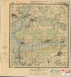
- Coordinates: 52, 32.25, 52.1667, 32.5
- Related URL:
- Catalog URL: http://iucat.iu.edu/catalog/5020131 and Download GeoTIFF: https://drive.google.com/open?id=1F40ViE0yDvGViIOC-bOSCTmjsYKUPP0M
- Abstract:
- Modern area represented: Kamenskiy Khutor, Bryansk oblast, Russia
- Call Number:
- G7000 s50 .S68 sheet N-36-137-D
- Caption:
- Не подлежит оглашению
- City:
- Каменский Хутор (Kamenskiy Khutor)
- Copyright Holder:
- No Copyright - United States
- Country:
- СССР (USSR)
- State/Province:
- Западная область (Western oblast), РСФСР (RSFSR), and Украинская ССР (Ukrainian Soviet Socialist Republic)
- Physical Description:
- Scale: 1:50,000
- Persistent URL:
- http://purl.dlib.indiana.edu/iudl/images/VAC9619/VAC9619-001580
- Provenance:
- M. I. Map Library, Atlasblatt
-
- Description:
- 1930
- Subject:
- Geographic Subject: Shumilovka, Topical Subject: Maps, and Topical Subject: Soviet Union
- Publisher:
- Управление военных топографов
- Language:
- Russian
- Identifier:
- VAC9619-001579
- Genre:
- Military Maps and Topographic Maps
- Geographic Location:
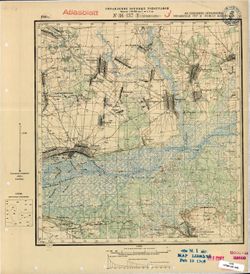
- Coordinates: 52, 32, 52.1667, 32.25
- Related URL:
- Download GeoTIFF: https://drive.google.com/open?id=1ag3f8ipdIBTu9si4SD7EBCIPQZrD4_po and Catalog URL: http://iucat.iu.edu/catalog/5020131
- Abstract:
- Modern area represented: Shumilovka, Bryansk oblast, Russia
- Call Number:
- G7000 s50 .S68 sheet N-36-137-C
- Caption:
- Не подлежит оглашению
- City:
- Шумиловка (Shumilovka)
- Copyright Holder:
- No Copyright - United States
- Country:
- СССР (USSR)
- State/Province:
- Западная область (Western oblast), РСФСР (RSFSR), and Украинская ССР (Ukrainian Soviet Socialist Republic)
- Physical Description:
- Scale: 1:50,000
- Persistent URL:
- http://purl.dlib.indiana.edu/iudl/images/VAC9619/VAC9619-001579
- Provenance:
- M. I. Map Library, Atlasblatt
-
- Description:
- 1930
- Subject:
- Topical Subject: Maps, Geographic Subject: Novyy Ropsk, and Topical Subject: Soviet Union
- Publisher:
- Управление военных топографов
- Language:
- Russian
- Identifier:
- VAC9619-001578
- Genre:
- Topographic Maps and Military Maps
- Geographic Location:
- Coordinates: 52.1667, 32.25, 52.3333, 32.5
- Related URL:
- Catalog URL: http://iucat.iu.edu/catalog/5020131 and Download GeoTIFF: https://drive.google.com/open?id=13t64kb76EHxk27fhUSp4LHrgQc7MI4jm
- Abstract:
- Modern area represented: Novyy Ropsk, Bryansk oblast, Russia
- Call Number:
- G7000 s50 .S68 sheet N-36-137-Б
- Caption:
- Не подлежит оглашению
- City:
- М. Нов. Ропск (Novyy Ropsk)
- Copyright Holder:
- No Copyright - United States
- Country:
- СССР (USSR)
- State/Province:
- Украинская ССР (Ukrainian Soviet Socialist Republic), РСФСР (RSFSR), and Западная область (Western oblast)
- Physical Description:
- Scale: 1:50,000
- Persistent URL:
- http://purl.dlib.indiana.edu/iudl/images/VAC9619/VAC9619-001578
- Provenance:
- M. I. Map Library, Atlasblatt
-
- Description:
- 1930
- Subject:
- Topical Subject: Maps, Geographic Subject: Churovichi, and Topical Subject: Soviet Union
- Publisher:
- Управление военных топографов
- Language:
- Russian
- Identifier:
- VAC9619-001577
- Genre:
- Topographic Maps and Military Maps
- Geographic Location:
- Coordinates: 52.1667, 32, 52.3333, 32.25
- Related URL:
- Download GeoTIFF: https://drive.google.com/open?id=1YYiYB76v1eGKgaj7wwzlZh2Pm243OTCJ and Catalog URL: http://iucat.iu.edu/catalog/5020131
- Abstract:
- Modern area represented: Churovichi, Bryansk oblast, Russia
- Call Number:
- G7000 s50 .S68 sheet N-36-137-A
- Caption:
- Не подлежит оглашению
- City:
- Чуровичи (Churovichi)
- Copyright Holder:
- No Copyright - United States
- Country:
- СССР (USSR)
- State/Province:
- Западная область (Western oblast) and РСФСР (RSFSR)
- Physical Description:
- Scale: 1:50,000
- Persistent URL:
- http://purl.dlib.indiana.edu/iudl/images/VAC9619/VAC9619-001577
- Provenance:
- G000-30
-
- Description:
- 1875
- Subject:
- Topical Subject: Soviet Union, Geographic Subject: Leova, and Topical Subject: Maps
- Publisher:
- Генеральный штаб РККА
- Language:
- Russian
- Date Created:
- 1940
- Identifier:
- VAC9619-001576
- Genre:
- Military Maps and Topographic Maps
- Geographic Location:
- Coordinates: 46.3333, 28, 46.6667, 28.5
- Related URL:
- Catalog URL: https://iucat.iu.edu/catalog/5020129 and Download GeoTIFF: https://drive.google.com/open?id=1W71to7iMT8UwC4o77msQuVXKGW3_2Y6g
- Abstract:
- Modern area represented: Leova, Leova district, Moldova
- Call Number:
- G7000 s100 .S7 sheet L-35-57
- City:
- Леово (Leovo)
- Copyright Holder:
- No Copyright - United States
- Country:
- Румыния (Romania)
- State/Province:
- Бессарабия (Bessarabia)
- Physical Description:
- Scale: 1:100,000
- Persistent URL:
- http://purl.dlib.indiana.edu/iudl/images/VAC9619/VAC9619-001576
- Provenance:
- CIA Map Library, Atlasblatt
-
- Description:
- 1929
- Subject:
- Topical Subject: Soviet Union, Geographic Subject: Rogov, and Topical Subject: Maps
- Publisher:
- Военно-топографическое управление
- Language:
- Russian
- Identifier:
- VAC9619-001575
- Genre:
- Topographic Maps and Military Maps
- Geographic Location:
- Coordinates: 52.1667, 31.75, 52.3333, 32
- Related URL:
- Download GeoTIFF: https://drive.google.com/open?id=1dA5Kx5cmuWAiQsNvN42a4-HpPtHvpoN6 and Catalog URL: http://iucat.iu.edu/catalog/5020131
- Abstract:
- Modern area represented: Rogov, Bryansk oblast, Russia
- Call Number:
- G7000 s50 .S68 sheet N-36-136-Б
- Caption:
- Не подлежит оглашению
- City:
- Рогов (Rogov)
- Copyright Holder:
- No Copyright - United States
- Country:
- СССР (USSR)
- State/Province:
- Западная область (Western oblast), РСФСР (RSFSR), and Белорусская ССР (Byelorussian Soviet Socialist Republic)
- Physical Description:
- Scale: 1:50,000
- Persistent URL:
- http://purl.dlib.indiana.edu/iudl/images/VAC9619/VAC9619-001575
- Provenance:
- G000-30
-
- Description:
- 1923
- Subject:
- Topical Subject: Soviet Union, Topical Subject: Maps, and Geographic Subject: Ogorodnya
- Publisher:
- Военно-топографическое управление
- Language:
- Russian
- Identifier:
- VAC9619-001574
- Genre:
- Topographic Maps and Military Maps
- Geographic Location:
- Coordinates: 52.1667, 31.5, 52.3333, 31.75
- Related URL:
- Catalog URL: http://iucat.iu.edu/catalog/5020131 and Download GeoTIFF: https://drive.google.com/open?id=1cw2R9AaZ8ZAzRWXedmEogRMPy8AsxYyA
- Abstract:
- Modern area represented: Ogorodnya, Homyel oblast, Belarus
- Call Number:
- G7000 s50 .S68 sheet N-36-136-A
- Caption:
- Секретно
- City:
- Огородня Гомельская (Ogorodnya-Gomelskaya)
- Copyright Holder:
- No Copyright - United States
- Country:
- СССР (USSR)
- State/Province:
- Западная область (Western oblast), РСФСР (RSFSR), and Белорусская ССР (Byelorussian Soviet Socialist Republic)
- Physical Description:
- Scale: 1:50,000
- Persistent URL:
- http://purl.dlib.indiana.edu/iudl/images/VAC9619/VAC9619-001574
- Provenance:
- G000-30
-
- Description:
- 1929
- Subject:
- Topical Subject: Maps, Geographic Subject: Perepis, and Topical Subject: Soviet Union
- Publisher:
- Военно-топографическое управление
- Language:
- Russian
- Identifier:
- VAC9619-001573
- Genre:
- Military Maps and Topographic Maps
- Geographic Location:
- Coordinates: 52, 31.25, 52.1667, 31.5
- Related URL:
- Download GeoTIFF: https://drive.google.com/open?id=1IRbUSwpZbhhRPZFIBdro4RVzKaabMFon and Catalog URL: http://iucat.iu.edu/catalog/5020131
- Abstract:
- Modern area represented: Perepis, Chernihiv oblast, Ukraine
- Call Number:
- G7000 s50 .S68 sheet N-36-135-Г
- Caption:
- Не подлежит оглашению
- City:
- Перепис (Perepis)
- Copyright Holder:
- No Copyright - United States
- Country:
- СССР (USSR)
- State/Province:
- Белорусская ССР (Byelorussian Soviet Socialist Republic) and Украинская ССР (Ukrainian Soviet Socialist Republic)
- Physical Description:
- Scale: 1:50,000
- Persistent URL:
- http://purl.dlib.indiana.edu/iudl/images/VAC9619/VAC9619-001573
- Provenance:
- G000-30
-

- Description:
- 1889
- Subject:
- Geographic Subject: Sighișoara, Topical Subject: Soviet Union, and Topical Subject: Maps
- Publisher:
- Генеральный штаб РККА
- Language:
- Russian
- Date Created:
- 1940
- Identifier:
- VAC9619-001572
- Genre:
- Topographic Maps and Military Maps
- Geographic Location:
- Coordinates: 46, 24.5, 46.3333, 25
- Related URL:
- Catalog URL: https://iucat.iu.edu/catalog/5020129 and Download GeoTIFF: https://drive.google.com/open?id=1pMjt1y7xJ_zezttERad19SLcAJyJ7ok-
- Abstract:
- Modern area represented: Sighișoara, Mureş county, Romania
- Call Number:
- G7000 s100 .S7 sheet L-35-62
- City:
- Сигишоара (Sighișoara)
- Copyright Holder:
- No Copyright - United States
- Country:
- Венгрия (Hungary) and Румыния (Romania)
- Physical Description:
- Scale: 1:100,000
- Persistent URL:
- http://purl.dlib.indiana.edu/iudl/images/VAC9619/VAC9619-001572
- Provenance:
- Library of Congress Geography & Map Division, Atlasblatt, DMA Topographic Center, Army Map Service Library, OMAHA
-
- Description:
- 1923
- Subject:
- Geographic Subject: Nasovichy, Topical Subject: Maps, and Topical Subject: Soviet Union
- Publisher:
- Управление военных топографов
- Language:
- Russian
- Identifier:
- VAC9619-001571
- Genre:
- Topographic Maps and Military Maps
- Geographic Location:
- Coordinates: 52.1667, 31.25, 52.3333, 31.5
- Related URL:
- Catalog URL: http://iucat.iu.edu/catalog/5020131 and Download GeoTIFF: https://drive.google.com/open?id=10rJAA9fYtU4y4aDEfDF16VBaltwvwW1O
- Abstract:
- Modern area represented: Nasovichy, Homyel Voblasc, Belarus
- Call Number:
- G7000 s50 .S68 sheet N-36-135-Б
- Caption:
- Не подлежит оглашению
- City:
- М. Носовичи (Nasovichy)
- Copyright Holder:
- No Copyright - United States
- Country:
- СССР (USSR)
- State/Province:
- Белорусская ССР (Byelorussian Soviet Socialist Republic)
- Physical Description:
- Scale: 1:50,000
- Persistent URL:
- http://purl.dlib.indiana.edu/iudl/images/VAC9619/VAC9619-001571
- Provenance:
- M. I. Map Library, Atlasblatt
