Indiana University
Indiana University
IU
Skip to Content
Digital Collections
Toggle navigation
Digital
Collections
Switch language
English
Switch language
Deutsch
English
Español
Français
Italiano
Português do Brasil
中文
Login
Home
About
Contact
Search Digital Collections
Go
×
Search Constraints
Start Over
You searched for:
Subject
Topical Subject: Land use
Remove constraint Subject: Topical Subject: Land use
« Previous |
1
-
10
of
55
|
Next »
Sort by relevance ▼
relevance ▼
recently updated
title ▲
title ▼
date created ▲
date created ▼
pages ▲
pages ▼
collection size ▲
collection size ▼
Number of results to display per page
10 per page
10
per page
20
per page
50
per page
100
per page
View results as:
List
Gallery
Masonry
Search Results
1.
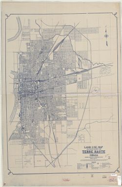
Land use map real property inventory, 1935 Terre Haute, Indiana
2.
[Monroe County, Indiana, existing use of land.] Sheet 14. Unincorporated communities, Monroe County, Indiana, existing use of land
3.
[Monroe County, Indiana, existing use of land.] Sheet 13. Washington Township, Monroe County, Indiana, existing use of land
4.
[Monroe County, Indiana, existing use of land.] Sheet 6. Van Buren Township, Monroe County, Indiana, existing use of land
5.
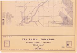
Van Buren Township, Monroe County, Indiana, zone map
6.
[Monroe County, Indiana, existing use of land.] Sheet 10. Salt Creek Township, Monroe County, Indiana, existing use of land
7.
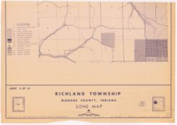
Richland Township, Monroe County, Indiana, zone map
8.
[Monroe County, Indiana, existing use of land.] Sheet 5. Richland Township, Monroe County, Indiana, existing use of land
9.
[Monroe County, Indiana, existing use of land.] Sheet 9. Polk Township, Monroe County, Indiana, existing use of land
10.
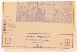
Perry Township, Monroe County, Indiana, zone map
« Previous
Next »
1
2
3
4
5
6
Toggle facets
Limit your search
Type
Image
55
Creator
Schellie Associates
18
Bartholomew County (Ind.). Land Use Planning Committee
1
Camiros, Ltd.
1
Clark County (Ind.). Land Use Planning Committee
1
Crawford County (Ind.). Land Use Planning Committee
1
Daviess County (Ind.). Land Use Planning Committee
1
Dearborn County (Ind.). Land Use Planning Committee
1
Dubois County (Ind.). Land Use Planning Committee
1
Fayette County (Ind.). Land Use Planning Committee
1
Floyd County (Ind.). Land Use Planning Committee
1
more
Creators
»
Subject
Topical Subject: Land use
[remove]
55
Geographic Subject: Monroe County (Ind.)
3
Geographic Subject: Benton (Monroe County, Ind. : Township)
2
Geographic Subject: Bloomington (Ind.)
2
Geographic Subject: Bloomington (Monroe County, Ind. : Township)
2
Geographic Subject: Perry (Monroe County, Ind. : Township)
2
Geographic Subject: Richland (Monroe County, Ind. : Township)
2
Geographic Subject: Van Buren (Monroe County, Ind. : Township)
2
Geographic Subject: Bartholomew County (Ind.)
1
Geographic Subject: Bean Blossom (Monroe County, Ind. : Township)
1
more
Subjects
»
Publisher
Schellie Associates
18
United States. Bureau of Agricultural Economics
9
[publisher not identified]
2
Bartholomew County (Ind.). Land Use Planning Committee
1
Camiros, Ltd.
1
Clark County (Ind.). Land Use Planning Committee
1
Crawford County (Ind.). Land Use Planning Committee
1
Dearborn County (Ind.). Land Use Planning Committee
1
Dubois County (Ind.). Land Use Planning Committee
1
Fayette County (Ind.). Land Use Planning Committee
1
more
Publishers
»
Date Created
1940
26
1961
13
1941
4
1963
4
1950
2
1935
1
1939
1
1969
1
1978
1
1995
1
Pages
0-99 pages
55
Collections
Indiana Historic Maps
55
State
deposited
55
Campus
IUB
55
Holding Location
B-WELLS
55
Provenance
Schellie Associates. Monroe County Indiana, Existing Use of Land. [Bloomington, Indiana] : Monroe County Plan Commission, 1961.
12
Schellie Associates. Monroe County Indiana, zone map. [Bloomington, Indiana] : Monroe County Plan Commission, 1963.
4
Monroe County, Indiana, Existing Use of Land
1
Salt Creek Township, Monroe County, Indiana, Existing Use of Land
1

![[Monroe County, Indiana, existing use of land.] Sheet 14. Unincorporated communities, Monroe County, Indiana, existing use of land](https://iiif.uits.iu.edu/iiif/2/zk51wj270%2Ffiles%2F62b7ef2f-84c1-4e40-a5e2-39ef248cf3ce/full/250,/0/default.jpg)
![[Monroe County, Indiana, existing use of land.] Sheet 13. Washington Township, Monroe County, Indiana, existing use of land](https://iiif.uits.iu.edu/iiif/2/nc581p990%2Ffiles%2F07609495-360c-4713-9c4e-887099eaa1cc/full/250,/0/default.jpg)
![[Monroe County, Indiana, existing use of land.] Sheet 6. Van Buren Township, Monroe County, Indiana, existing use of land](https://iiif.uits.iu.edu/iiif/2/js957j36n%2Ffiles%2Fb7c53c79-855f-4c3c-87bb-abc60884f2ba/full/250,/0/default.jpg)
![[Monroe County, Indiana, existing use of land.] Sheet 10. Salt Creek Township, Monroe County, Indiana, existing use of land](https://iiif.uits.iu.edu/iiif/2/41688m61r%2Ffiles%2F794b5ec7-9465-4a56-a95f-23c98afc60dc/full/250,/0/default.jpg)
![[Monroe County, Indiana, existing use of land.] Sheet 5. Richland Township, Monroe County, Indiana, existing use of land](https://iiif.uits.iu.edu/iiif/2/2z10xt559%2Ffiles%2Fccd422c0-2373-4819-b6e9-60a0db266735/full/250,/0/default.jpg)
![[Monroe County, Indiana, existing use of land.] Sheet 9. Polk Township, Monroe County, Indiana, existing use of land](https://iiif.uits.iu.edu/iiif/2/th83n346m%2Ffiles%2F98da6cf6-258c-482d-aae7-a3cd05bc5456/full/250,/0/default.jpg)