
Search Constraints
You searched for:
Subject
Geographic Subject: Newton County (Ind.)
Remove constraint Subject: Geographic Subject: Newton County (Ind.)
1 - 7 of 7
Search Results
-
![Illinois-Indiana, Watseka quadrangle [1939 printing]](https://iiif.uits.iu.edu/iiif/2/s4656k49c%2Ffiles%2F4facd9e8-e703-4a71-992c-b586d52778ed/full/250,/0/default.jpg)
- Subject:
- Geographic Subject: Iroquois County (Ill.) and Geographic Subject: Newton County (Ind.)
- Creator:
- Schultz, J. T. (Jack Thurman), 1899-1972 and Geological Survey (U.S.)
- Publisher:
- Geological Survey (U.S.)
- Date Created:
- 1939
- Identifier:
- VAC3073-M-01413
- Genre:
- Quadrangle maps, 15 minute topographic maps, and Topographic maps
- Geographic Location:
- Coordinates: W0874500 W0873000 N0410000 N0404500
- Related URL:
- Catalog URL: https://iucat.iu.edu/catalog/18416003
- Abstract:
- Topography by J.T. Schultz, R.G. Shirley, T.B. McNeill, and H. McDermith. Filing title: Watseka, Ill.-Ind. Polyconic projection. Relief shown by contours and...
- Call Number:
- G4090 s62 .G4 Wateska 1939
- Caption:
- Imprint: [Washington, D.C.] : Geological Survey, [1939]
- Physical Description:
- Dimensions: 45 x 42 cm or smaller and Scale: 1:62,500
- Alternate Identifier:
- Title Control Number: a18416003
- Persistent URL:
- https://purl.dlib.indiana.edu/iudl/images/VAC3073/VAC3073-M-01413
- Provenance:
- Part of Geological Survey (U.S.). Indiana 1:62,500.
-
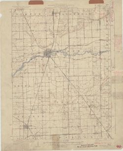
- Subject:
- Geographic Subject: Lake County (Ind.), Geographic Subject: Newton County (Ind.), Geographic Subject: Kanakee County (Ill.), and Geographic Subject: Iroquois...
- Creator:
- Geological Survey (U.S.), U.S. Lake Survey, Illinois State Geological Survey, Jennings, J. H. (James H.), 1864-1927, and Illinois. Department of Registration...
- Publisher:
- Geological Survey (U.S.)
- Date Created:
- 1924
- Identifier:
- VAC3073-M-01350
- Genre:
- Quadrangle maps, Topographic maps, and 15 minute topographic maps
- Geographic Location:
- Coordinates: W0874500 W0873000 N0411500 N0410000
- Related URL:
- Catalog URL: https://iucat.iu.edu/catalog/18408408
- Abstract:
- Filing title: Momence, Ill.-Ind. Polyconic projection. Relief shown by contours and spot heights. Shows Kankakee County, Illinois, as well as small portions ...
- Call Number:
- G4090 s62 .G4 Momence 1924
- Caption:
- Imprint: [Urbana, Ill.] : Geological Survey Division, 1924 and Imprint: [Washington, D.C.] : U.S. Geological Survey
- Physical Description:
- Dimensions: 45 x 42 cm or smaller and Scale: 1:62,500
- Alternate Identifier:
- Title Control Number: a18408408
- Persistent URL:
- https://purl.dlib.indiana.edu/iudl/images/VAC3073/VAC3073-M-01350
- Provenance:
- Part of Geological Survey (U.S.). Indiana 1:62,500.
-
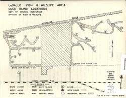
- Subject:
- Geographic Subject: Lake County (Ind.), Geographic Subject: Newton County (Ind.), Topical Subject: Blinds (Hunting), Topical Subject: Waterfowl shooting--Law...
- Creator:
- Indiana. Division of Fish and Wildlife
- Publisher:
- Indiana. Division of Fish and Wildlife
- Date Created:
- 1971
- Identifier:
- VAC3073-M-01270
- Genre:
- Thematic maps
- Geographic Location:
- Coordinates: W0873136 W0872652 N0411057 N0410840
- Related URL:
- Catalog URL: https://iucat.iu.edu/catalog/18405988
- Abstract:
- Title on verso: Migratory waterfowl hunting rules and regulations : LaSalle Fish and Wildlife Area. Shows roads, water areas, duck blinds, headquarters, park...
- Call Number:
- G4091.E63 svar .I5 LaSalle 2
- Caption:
- Imprint: [Indianapolis?] : [The Division], 1971.
- Physical Description:
- Dimensions: 36 x 22 cm or smaller and Scale: Scale not given.
- Alternate Identifier:
- Title Control Number: a18405988
- Persistent URL:
- https://purl.dlib.indiana.edu/iudl/images/VAC3073/VAC3073-M-01270
- Provenance:
- Indiana state fish and wildlife areas. Department of Natural Resources. Division of Fish and Wildlife. [Indianapolis?] : The Division, 1971-.
-
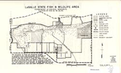
- Subject:
- Topical Subject: Game laws, Topical Subject: Wildlife management areas, Geographic Subject: LaSalle Fish and Wildlife Area (Ind.), Geographic Subject: Newton...
- Creator:
- Indiana. Division of Fish and Wildlife
- Publisher:
- Indiana. Division of Fish and Wildlife
- Date Created:
- 1971
- Identifier:
- VAC3073-M-01261
- Genre:
- Thematic maps
- Geographic Location:
- Coordinates: W0873136 W0872652 N0411057 N0410840
- Related URL:
- Catalog URL: https://iucat.iu.edu/catalog/18405983
- Abstract:
- Title on verso: Rules and regulations : LaSalle Fish and Wildlife Area. Shows hunting, water, and waterfowl resting areas, as well as marshes, railroads, par...
- Call Number:
- G4091.E63 svar .I5 LeSalle 1
- Caption:
- Imprint: [Indianapolis?] : [The Division], 1971.
- Physical Description:
- Dimensions: 36 x 22 cm or smaller and Scale: Approximately 1:28,000
- Alternate Identifier:
- Title Control Number: a18405983
- Persistent URL:
- https://purl.dlib.indiana.edu/iudl/images/VAC3073/VAC3073-M-01261
- Provenance:
- Indiana state fish and wildlife areas. Department of Natural Resources. Division of Fish and Wildlife. [Indianapolis?] : The Division, 1971-.
-
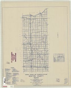
- Subject:
- Geographic Subject: Newton County (Ind.) and Topical Subject: Roads
- Creator:
- Indiana. State Highway Commission (1919-1953)
- Publisher:
- State Highway Commission of Indiana
- Date Created:
- 1949
- Identifier:
- VAC3073-M-00719
- Genre:
- Road maps
- Geographic Location:
- Coordinates: W0873200 W0871600 N0411400 N0404400
- Related URL:
- Catalog URL: https://iucat.iu.edu/catalog/5707499
- Abstract:
- Blueline. "State roads revised to January 1, 1949." "1937." "Data obtained from State-wide Highway Planning Survey." Includes l...
- Call Number:
- G4093.N4 P2 1949 .I53
- Caption:
- Imprint: [Indianapolis?] : State Highway Commission of Indiana, 1949.
- Physical Description:
- Dimensions: 52 x 44 cm and Scale: 1:130,000
- Alternate Identifier:
- Title Control Number: a5707499
- Persistent URL:
- https://purl.dlib.indiana.edu/iudl/images/VAC3073/VAC3073-M-00719
-
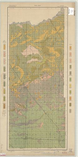
- Subject:
- Geographic Subject: Putnam County (Ind.), Geographic Subject: Benton County (Ind.), Geographic Subject: Fountain County (Ind.), Geographic Subject: Newton Co...
- Creator:
- Ashley, Geo. H. (George Hall), 1866-1951, Siebenthal, C. E. (Claude Ellsworth), 1869-1930, and Kindle, E. M. (Edward Martin), 1869-1940
- Publisher:
- Indiana. Department of Geology and Natural Resources
- Date Created:
- 1899
- Identifier:
- VAC3073-M-00270
- Genre:
- Geological cross-sections and Geological maps
- Geographic Location:
- Coordinates: W0873200 W0865200 N0403000 N0393600
- Related URL:
- Catalog URL: https://iucat.iu.edu/catalog/18265361
- Abstract:
- Relief shown by spot heights. Includes map showing coal locations and features, railroads, and quarries as well as two inset maps for parts of Newton and Ben...
- Call Number:
- G4093.W3H9 1898 .A84
- Caption:
- Imprint: Indianapolis, Ind. : Wm. B. Burford, [1899]
- Physical Description:
- Dimensions: 79 x 48 cm and Scale: Approximately 1:126,720. 2 miles = 1 inch
- Alternate Identifier:
- Alternate ID: 390726IP and Title Control Number: a18265361
- Persistent URL:
- https://purl.dlib.indiana.edu/iudl/images/VAC3073/VAC3073-M-00270
- Provenance:
- 23rd Annual Report (1898) / Indiana. Department of Geology and Natural Resources.
-
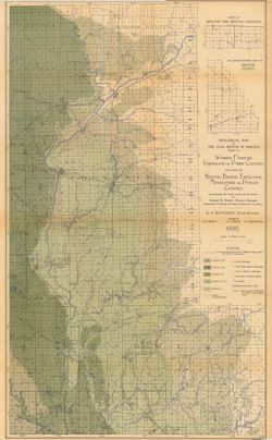
- Subject:
- Geographic Subject: Newton County (Ind.) and Topical Subject: Soils
- Creator:
- Neill, N. P. (Nelson Prentice)
- Publisher:
- United States. Bureau of Soils
- Date Created:
- 1905
- Identifier:
- VAC3073-M-00047
- Genre:
- Thematic maps
- Geographic Location:
- Coordinates: W0873200 W0871600 N0411400 N0404400
- Related URL:
- Catalog URL: https://iucat.iu.edu/catalog/2873371
- Abstract:
- Shows soil types classification by colors and symbols. "Field Operations, Bureau of Soils, 1905." "A. Hoen & Co. Lith. Baltimore, Md."
- Call Number:
- G4093 .N4J3 1905 .N45
- Caption:
- Imprint: Washington, D.C.: Bureau of Soils. [1905]
- Physical Description:
- Scale: 1:63,360 and Dimensions: 86 x 35 cm
- Alternate Identifier:
- Title Control Number: CAY9035BB
- Persistent URL:
- https://purl.dlib.indiana.edu/iudl/images/VAC3073/VAC3073-M-00047
