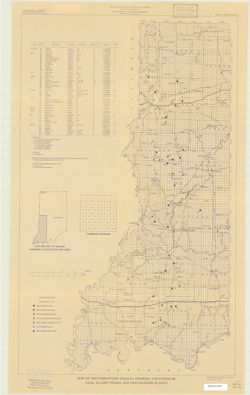
Geographic Subject: Spencer County (Ind.), Topical Subject: Coal mines and mining, and Topical Subject: Coal
Creator:
Hutchison, Harold C. (Harold Christy), 1925-
Publisher:
Indiana. Geological Survey
Date Created:
1959
Identifier:
VAC3073-M-00222
Genre:
Mine maps and Thematic maps
Geographic Location:
Coordinates: W0871600 W0844600 N0381200 N0374700
Related URL:
Catalog URL: https://iucat.iu.edu/catalog/5389271
Abstract:
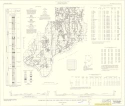
"Preliminary Coal Map no. 8". Includes 2 geologic cross sections, location map, geologic column, index of mines, tables, and diagram of township se...
Call Number:
G4093.S5H9 1959 .H8
Caption:
Imprint: Bloomington, Ind. : Indiana Department of Conservation, Geological Survey, 1959.
Topical Subject: Administrative and political divisions and Geographic Subject: Indiana
Creator:
Moran, W. H. (William H.)
Publisher:
Indiana. Geological Survey
Date Created:
1952
Identifier:
VAC3073-M-00215
Genre:
Maps
Geographic Location:
Coordinates: W0880500 W0844700 N0414500 N0374600
Related URL:
Catalog URL: https://iucat.iu.edu/catalog/1233088
Abstract:
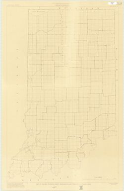
"January 1952." Black line print. "Traced from Map of Indiana, edition of 1950, published by U.S. Geological Survey. Minor revisions and addit...
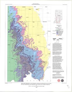
Topical Subject: Geology and Geographic Subject: Indiana
Creator:
Patton, John B. (John Barratt), 1915-
Publisher:
Indiana. Geological Survey
Date Created:
1956
Identifier:
VAC3073-M-00212
Genre:
Geological maps
Geographic Location:
Coordinates: W0880000 W0844500 N0414500 N0375200
Related URL:
Catalog URL: https://iucat.iu.edu/catalog/5888483
Abstract:
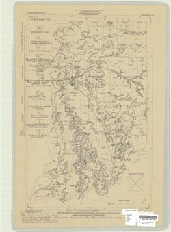
"Base from Map of Indiana, 1950 edition, published by the U.S. Geological Survey. Minor revisions and additions made from Indiana Department of Conserva...
Geographic Subject: Porter County (Ind.), Geographic Subject: Indiana, Geographic Subject: Michigan, Lake, Coast (Ind.), Topical Subject: Lakes, Topical Subj...
Creator:
Thompson, Todd A. (Todd Alan), 1959-
Publisher:
Indiana. Geological Survey
Date Created:
2000
Identifier:
VAC3073-M-00193
Genre:
Thematic maps
Geographic Location:
Coordinates: W0873136 W0871307 N0414539 N0410943
Related URL:
Catalog URL: https://iucat.iu.edu/catalog/4898581
Abstract:
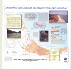
Includes illustrations, text, graphs showing "Lake-level fluctuations over the past 4,700 years" and a timeline showing historical events since 116...
Topical Subject: Caves, Geographic Subject: Indiana, Topical Subject: Springs, Topical Subject: Sinkholes, and Topical Subject: Karst
Creator:
Powell, Richard L.
Publisher:
Indiana. Geological Survey
Date Created:
2002
Identifier:
VAC3073-M-00135
Genre:
Geological maps
Geographic Location:
Coordinates: W0870002 W0854608 N0394722 N0375826
Related URL:
Catalog URL: https://iucat.iu.edu/catalog/5325676
Abstract:
"This map data was compiled in 1997 from information available at the time, but was unpublished until until 2002, the map does not reflect any changes i...
Topical Subject: Administrative and political divisions and Geographic Subject: Indiana
Creator:
Moran, W. H. (William H.)
Publisher:
Indiana. Geological Survey
Date Created:
1951
Identifier:
VAC3073-M-00001
Genre:
Maps
Geographic Location:
Coordinates: W0880500 W0844700 N0414500 N0374600
Related URL:
Catalog URL: https://iucat.iu.edu/catalog/1233513
Abstract:
Photocopy, 118 x 77 cm "November, 1951." "Traced from compilation proof sheets of new base map of Indiana, prepared by the U.S. Geological Sur...