R. B. Marshall, chief geographer , W. H. Herron, Geographer in charge , topography by W. H. Griffin and C. L. Sandler , Control by J. R. Ellis and C. H. Semp...
Call Number:
G4090 s62 .G4 Bloomington 1910 R1931
Caption:
Imprint: [Washington, D.C.] : United States, Department of the Interior, Geological Survey, [1931]
Physical Description:
Scale: 1:62,500 and Dimensions: 45 x 42 cm or smaller
Geographic Subject: Warrick County (Ind.), Geographic Subject: Dubois County (Ind.), Geographic Subject: Spencer County (Ind.), and Geographic Subject: Pike ...
Creator:
Renshawe, John H., Goodlove, C. W., Geological Survey (U.S.), and Hawkins, Geo. T. (George T.)
Publisher:
Geological Survey (U.S.)
Date Created:
1936
Identifier:
VAC3073-M-01293
Genre:
15 minute topographic maps, Topographic maps, and Quadrangle maps
Engraved Oct. 1902 by U.S.G.S. , Jno. Renshawe, geographer in charge , control by Geo. T. Hawkins , topography by Chas. W. Goodlove. Filing title: Degonia Sp...
Call Number:
G4090 s62 .G4 Degonia Springs 1902 rep1936
Caption:
Imprint: [Washington, D.C.] : U.S. Geological Survey, 1936
Physical Description:
Scale: 1:62,500 and Dimensions: 45 x 42 cm or smaller
Geographic Subject: Johnson County (Ind.), Geographic Subject: Shelby County (Ind.), Geographic Subject: Bartholomew County (Ind.), and Topical Subject: Vege...
Creator:
Geological Survey (U.S.) and United States. Army. Corps of Engineers
Geographic Subject: Brown County (Ind.), Geographic Subject: Johnson County (Ind.), Geographic Subject: Bartholomew County (Ind.), and Topical Subject: Veget...
Creator:
United States. Army. Corps of Engineers and Geological Survey (U.S.)
Filing title: Franklin, Ind. Mapped, edited, and published by Geological Survey. Edition of 1950. Polyconic projection. Relief shown by contours and spot hei...
R. B. Marshall, chief geographer , W. H. Herron, Geographer in charge , topography by W. H. Griffin and C. L. Sandler , Control by J. R. Ellis and C. H. Semp...
Call Number:
G4090 s62 .G4 Bloomington 1910 R1948
Caption:
Imprint: [Washington, D.C.] : United States, Department of the Interior, Geological Survey, [1948]
Physical Description:
Dimensions: 45 x 42 cm or smaller and Scale: 1:62,500
R. B. Marshall, chief geographer , W. H. Herron, Geographer in charge , topography by W. H. Griffin and C. L. Sandler , Control by J. R. Ellis and C. H. Semp...
Call Number:
G4090 s62 .G4 Bloomington 1910 R1946
Caption:
Imprint: [Washington, D.C.] : United States, Department of the Interior, Geological Survey, [1946]
Physical Description:
Scale: 1:62,500 and Dimensions: 45 x 42 cm or smaller
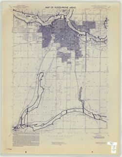
Geographic Subject: Madison County (Ind.), Topical Subject: Floodplains, Geographic Subject: Anderson Region (Ind.), Topical Subject: Floods, and Topical Sub...
Creator:
Geological Survey (U.S.)
Publisher:
Geological Survey (U.S.)
Date Created:
1973
Identifier:
VAC3073-M-01007
Genre:
Topographic maps, Quadrangle maps, and 7.5 minute topographic maps
Filing title: Anderson South, Ind. Relief shown by contours and spot heights. Contour interval 10 feet. Includes quadrangle location map. Flood prone areas a...

![Indiana Bloomington quadrangle [1931 reprint]](https://iiif.uits.iu.edu/iiif/2/k356b6534%2Ffiles%2F0825088b-bc9a-4258-b21f-7c4300529747/full/250,/0/default.jpg)
![Indiana Degonia Springs quadrangle [1936 reprint]](https://iiif.uits.iu.edu/iiif/2/x346f640t%2Ffiles%2F0b272452-2a1a-4415-897a-e57e4a8c1f70/full/250,/0/default.jpg)
![Edinburg Quadrangle Indiana : 15 minute series (topographic) [1950 printing with vegetation]](https://iiif.uits.iu.edu/iiif/2/4b29c880r%2Ffiles%2F58f84ee1-c680-40d2-9a78-baf3613c076f/full/250,/0/default.jpg)
![Edinburg Quadrangle Indiana : 15 minute series (topographic) [1950 printing without vegetation]](https://iiif.uits.iu.edu/iiif/2/3b592c294%2Ffiles%2F06928e89-6508-4c49-a4ff-7f390a205f57/full/250,/0/default.jpg)
![Franklin Quadrangle Indiana : 15 minute series (topographic) [1964 reprint with vegetation]](https://iiif.uits.iu.edu/iiif/2/6q183p48p%2Ffiles%2Fc56a46c5-d4c7-4d8d-bc73-62e73b26e4c3/full/250,/0/default.jpg)
![Indiana Bloomington quadrangle [1948 reprint]](https://iiif.uits.iu.edu/iiif/2/2j62t788s%2Ffiles%2F57d817cb-ee47-4ed5-9f38-24d8a93dcb0b/full/250,/0/default.jpg)
![Indiana Bloomington quadrangle [1946 reprint with 21 indexed cave locations]](https://iiif.uits.iu.edu/iiif/2/dz011t645%2Ffiles%2Fbb3033b6-3144-4af2-a6c7-a5710771ff06/full/250,/0/default.jpg)