
Search Constraints
You searched for:
Date Created
1939
Remove constraint Date Created: 1939
Holding Location
B-WELLS
Remove constraint Holding Location: B-WELLS
Search Results
-
- Subject:
- Topical Subject: Real property, Topical Subject: Landowners, and Geographic Subject: Bean Blossom (Monroe County, Ind. : Township)
- Creator:
- Stevens, Katherine (Mapmaker)
- Publisher:
- Stevens, Katherine (Mapmaker)
- Date Created:
- 1939
- Identifier:
- VAC3073-M-01520
- Genre:
- Cadastral maps
- Geographic Location:
- Coordinates: W0864107 W0863429 N0392125 N0391505
- Related URL:
- Catalog URL: https://iucat.iu.edu/catalog/18408228
- Abstract:
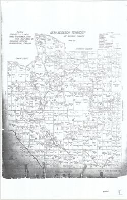
- Made by Katherine Stevens. Title in lower right corner: Plat #1, Bean Blossom Twp. Shows roads, creeks, railroads, churches, cemeteries, schools, and owner n...
- Call Number:
- G4093.M7G46 1939 .S74 Bean Blossom
- Caption:
- Imprint: Bloomington, Indiana : Katherine Stevens, [1939]
- Physical Description:
- Scale: Approximately 1:18,000. 1,500 feet = 1 inch and Dimensions: on sheet 92 x 59 cm
- Alternate Identifier:
- Title Control Number: a18408228
- Persistent URL:
- https://purl.dlib.indiana.edu/iudl/images/VAC3073/VAC3073-M-01520
- Provenance:
- Katherine Stevens. Township maps of Monroe County, Indiana, [1939]
-
- Subject:
- Topical Subject: Real property, Topical Subject: Landowners, and Geographic Subject: Salt Creek (Monroe County, Ind. : Township)
- Creator:
- Stevens, Katherine (Mapmaker)
- Publisher:
- Stevens, Katherine (Mapmaker)
- Date Created:
- 1939
- Identifier:
- VAC3073-M-01519
- Genre:
- Cadastral maps
- Geographic Location:
- Coordinates: W0862738 W0862209 N0390953 N0390440
- Related URL:
- Catalog URL: https://iucat.iu.edu/catalog/18408344
- Abstract:
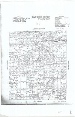
- Made by Katherine Stevens. Title in lower right corner: Plat #9, Salt Creek Twp. Shows roads, creeks, churches, cemeteries, schools, and owner names with acr...
- Call Number:
- G4093.M7G46 1939 .S74 Salt Creek
- Caption:
- Imprint: Bloomington, Indiana : Katherine Stevens, [1939]
- Physical Description:
- Scale: 1:18,000. 1,500 feet = 1 inch and Dimensions: on sheet 92 x 59 cm
- Alternate Identifier:
- Title Control Number: a18408344
- Persistent URL:
- https://purl.dlib.indiana.edu/iudl/images/VAC3073/VAC3073-M-01519
- Provenance:
- Katherine Stevens. Township maps of Monroe County, Indiana, [1939]
-
- Subject:
- Geographic Subject: Richland (Monroe County, Ind. : Township), Topical Subject: Real property, and Topical Subject: Landowners
- Creator:
- Stevens, Katherine (Mapmaker)
- Publisher:
- Stevens, Katherine (Mapmaker)
- Date Created:
- 1939
- Identifier:
- VAC3073-M-01518
- Genre:
- Cadastral maps
- Geographic Location:
- Coordinates: W0864102 W0863423 N0391509 N0390951
- Related URL:
- Catalog URL: https://iucat.iu.edu/catalog/18409340
- Abstract:
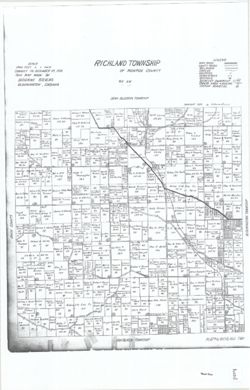
- Made by Katherine Stevens. Title in lower right corner: Plat #4, Richland Twp. Shows roads, creeks, railroads, churches, cemeteries, schools, and owner names...
- Call Number:
- G4093.M7G46 1939 .S74 Richland
- Caption:
- Imprint: Bloomington, Indiana : Katherine Stevens, [1939]
- Physical Description:
- Dimensions: on sheet 92 x 59 cm and Scale: Approximately 1:18,000. 1,500 feet = 1 inch
- Alternate Identifier:
- Title Control Number: a18409340
- Persistent URL:
- https://purl.dlib.indiana.edu/iudl/images/VAC3073/VAC3073-M-01518
- Provenance:
- Katherine Stevens. Township maps of Monroe County, Indiana, [1939]
-
- Subject:
- Topical Subject: Landowners, Geographic Subject: Clear Creek (Monroe County, Ind. : Township), and Topical Subject: Real property
- Creator:
- Stevens, Katherine (Mapmaker)
- Publisher:
- Stevens, Katherine (Mapmaker)
- Date Created:
- 1939
- Identifier:
- VAC3073-M-01517
- Genre:
- Cadastral maps
- Geographic Location:
- Coordinates: W0863409 W0862740 N0390438 N0385938
- Related URL:
- Catalog URL: https://iucat.iu.edu/catalog/18409339
- Abstract:
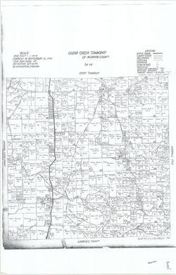
- Made by Katherine Stevens. Title in lower right corner: Plat #11, Clear Creek Twp. Shows roads, creeks, railroads, churches, cemeteries, schools, and owner n...
- Call Number:
- G4093.M7G46 1939 .S74 Clear Creek
- Caption:
- Imprint: Bloomington, Indiana : Katherine Stevens, [1939]
- Physical Description:
- Scale: 1:18,000. 1,500 feet = 1 inch and Dimensions: on sheet 92 x 59 cm
- Alternate Identifier:
- Title Control Number: a18409339
- Persistent URL:
- https://purl.dlib.indiana.edu/iudl/images/VAC3073/VAC3073-M-01517
- Provenance:
- Katherine Stevens. Township maps of Monroe County, Indiana, [1939]
-
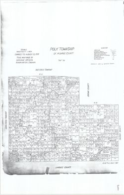
- Subject:
- Geographic Subject: Polk (Monroe County, Ind. : Township), Topical Subject: Landowners, and Topical Subject: Real property
- Creator:
- Stevens, Katherine (Mapmaker)
- Publisher:
- Stevens, Katherine (Mapmaker)
- Date Created:
- 1939
- Identifier:
- VAC3073-M-01516
- Genre:
- Cadastral maps
- Geographic Location:
- Coordinates: W0862741 W0861901 N0390447 N0385936
- Related URL:
- Catalog URL: https://iucat.iu.edu/catalog/18408242
- Abstract:
- Made by Katherine Stevens. Title in lower right corner: Plat #12, Polk Twp. Shows roads, creeks, churches, cemeteries, schools, and owner names with acreage....
- Call Number:
- G4093.M7G46 1939 .S74 Polk
- Caption:
- Imprint: Bloomington, Indiana : Katherine Stevens, [1939]
- Physical Description:
- Scale: 1:18,000. 1,500 feet = 1 inch and Dimensions: on sheet 92 x 59 cm
- Alternate Identifier:
- Title Control Number: a18408242
- Persistent URL:
- https://purl.dlib.indiana.edu/iudl/images/VAC3073/VAC3073-M-01516
- Provenance:
- Katherine Stevens. Township maps of Monroe County, Indiana, [1939]
-
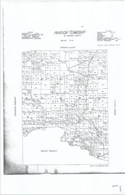
- Subject:
- Topical Subject: Real property, Geographic Subject: Marion (Monroe County, Ind. : Township), Geographic Subject: Benton (Monroe County, Ind. : Township), and...
- Creator:
- Stevens, Katherine (Mapmaker)
- Publisher:
- Stevens, Katherine (Mapmaker)
- Date Created:
- 1939
- Identifier:
- VAC3073-M-01514
- Genre:
- Cadastral maps
- Geographic Location:
- Coordinates: W0862748 W0862250 N0392024 N0391624
- Related URL:
- Catalog URL: https://iucat.iu.edu/catalog/18409341
- Abstract:
- Made by Katherine Stevens. Title in lower right corner: Plat #3, Marion Twp. Shows roads, creeks, churches, cemeteries, schools, and owner names with acreage...
- Call Number:
- G4093.M7G46 1939 .S74 Marion
- Caption:
- Imprint: Bloomington, Indiana : Katherine Stevens, [1939]
- Physical Description:
- Scale: Approximately 1:18,000. 1,500 feet = 1 inch and Dimensions: on sheet 92 x 59 cm
- Alternate Identifier:
- Title Control Number: a18409341
- Persistent URL:
- https://purl.dlib.indiana.edu/iudl/images/VAC3073/VAC3073-M-01514
- Provenance:
- Katherine Stevens. Township maps of Monroe County, Indiana, [1939]
-
![Illinois-Indiana, Watseka quadrangle [1939 printing]](https://iiif.uits.iu.edu/iiif/2/s4656k49c%2Ffiles%2F4facd9e8-e703-4a71-992c-b586d52778ed/full/250,/0/default.jpg)
- Subject:
- Geographic Subject: Iroquois County (Ill.) and Geographic Subject: Newton County (Ind.)
- Creator:
- Schultz, J. T. (Jack Thurman), 1899-1972 and Geological Survey (U.S.)
- Publisher:
- Geological Survey (U.S.)
- Date Created:
- 1939
- Identifier:
- VAC3073-M-01413
- Genre:
- Quadrangle maps, 15 minute topographic maps, and Topographic maps
- Geographic Location:
- Coordinates: W0874500 W0873000 N0410000 N0404500
- Related URL:
- Catalog URL: https://iucat.iu.edu/catalog/18416003
- Abstract:
- Topography by J.T. Schultz, R.G. Shirley, T.B. McNeill, and H. McDermith. Filing title: Watseka, Ill.-Ind. Polyconic projection. Relief shown by contours and...
- Call Number:
- G4090 s62 .G4 Wateska 1939
- Caption:
- Imprint: [Washington, D.C.] : Geological Survey, [1939]
- Physical Description:
- Dimensions: 45 x 42 cm or smaller and Scale: 1:62,500
- Alternate Identifier:
- Title Control Number: a18416003
- Persistent URL:
- https://purl.dlib.indiana.edu/iudl/images/VAC3073/VAC3073-M-01413
- Provenance:
- Part of Geological Survey (U.S.). Indiana 1:62,500.
-
![Indiana (Lake County) Tolleston quadrangle [1939 reprint]](https://iiif.uits.iu.edu/iiif/2/6108wd719%2Ffiles%2F57b5a9e6-6bbb-4ee3-8635-de3edfe763d1/full/250,/0/default.jpg)
- Subject:
- Geographic Subject: Lake County (Ind.)
- Creator:
- U.S. Lake Survey, McKinney, R. C. (Robert C.), Geological Survey (U.S.), and Renshawe, John H.
- Publisher:
- Geological Survey (U.S.)
- Date Created:
- 1939
- Identifier:
- VAC3073-M-01400
- Genre:
- Topographic maps, 15 minute topographic maps, and Quadrangle maps
- Geographic Location:
- Coordinates: W0873000 W0871500 N0414500 N0413000
- Related URL:
- Catalog URL: https://iucat.iu.edu/catalog/18406229
- Abstract:
- United States, Department of the Interior, Geological Survey , Jno. H. Renshawe, geographer in charge , control by U.S. Lake Survey , topography by R. C. McK...
- Call Number:
- G4090 s62 .G4 Toleston 1900 rep1939
- Caption:
- Imprint: Washington, D. C. : United States, Department of the Interior, Geological Survey, 1939
- Physical Description:
- Scale: 1:62,500 and Dimensions: 45 x 42 cm or smaller
- Alternate Identifier:
- Title Control Number: a18406229
- Persistent URL:
- https://purl.dlib.indiana.edu/iudl/images/VAC3073/VAC3073-M-01400
- Provenance:
- Part of Geological Survey (U.S.). Indiana 1:62,500.
-
![Indiana-Kentucky Owensboro quadrangle [1939 reprint]](https://iiif.uits.iu.edu/iiif/2/vh53xz17f%2Ffiles%2F2a5358ca-9489-45f4-bdc4-1efa562d3cd9/full/250,/0/default.jpg)
- Subject:
- Geographic Subject: Spencer County (Ind.), Geographic Subject: Warrick County (Ind.), and Geographic Subject: Daviess County (Ky.)
- Creator:
- Renshawe, John H., Geological Survey (U.S.), Hawkins, Geo. T. (George T.), and Cooke, Chas. E. (Charles E.)
- Publisher:
- Geological Survey (U.S.)
- Date Created:
- 1939
- Identifier:
- VAC3073-M-01375
- Genre:
- Quadrangle maps, Topographic maps, and 15 minute topographic maps
- Geographic Location:
- Coordinates: W0871500 W0870000 N0380000 N0374500
- Related URL:
- Catalog URL: https://iucat.iu.edu/catalog/18413576
- Abstract:
- John H. Renshaw, geographer in charge , control by George T. Hawkins , topography by Chas. E. Cooke. Filing title: Owensboro, Ind.-Ky. Edition of Nov. 1901. ...
- Call Number:
- G4090 s62 .G4 Owensboro 1901 rep 1939
- Caption:
- Imprint: Washington, D.C. : U.S. Geological Survey, 1939
- Physical Description:
- Dimensions: 45 x 42 cm or smaller and Scale: 1:62,500
- Alternate Identifier:
- Title Control Number: a18413576
- Persistent URL:
- https://purl.dlib.indiana.edu/iudl/images/VAC3073/VAC3073-M-01375
- Provenance:
- Part of Geological Survey (U.S.). Indiana 1:62,500.
-
![Illinois-Indiana-Kentucky, New Haven quadrangle [1939 reprint without vegetation]](https://iiif.uits.iu.edu/iiif/2/qj72qc053%2Ffiles%2Fbde64e1d-6659-4d18-a8c8-db54ce923770/full/250,/0/default.jpg)
- Subject:
- Geographic Subject: Union County (Ky.), Geographic Subject: Gallatin County (Ill.), Geographic Subject: White County (Ill.), and Geographic Subject: Posey Co...
- Creator:
- Geological Survey (U.S.)
- Publisher:
- Geological Survey (U.S.)
- Date Created:
- 1939
- Identifier:
- VAC3073-M-01359
- Genre:
- Quadrangle maps, Topographic maps, and 15 minute topographic maps
- Geographic Location:
- Coordinates: W0881500 W0880000 N0380000 N0374500
- Related URL:
- Catalog URL: https://iucat.iu.edu/catalog/18413859
- Abstract:
- United States, Department of the Interior, Geological Survey , State of Illinois, Department of Registration and Education, Geological Survey Division , Stat...
- Call Number:
- G4090 s62 .G4 New Haven 1906 rep 1939
- Caption:
- Imprint: [Washington, D.C.] : U.S. Geological Survey, [1939]
- Physical Description:
- Dimensions: 45 x 42 cm or smaller and Scale: 1:62,500
- Alternate Identifier:
- Title Control Number: a18413859
- Persistent URL:
- https://purl.dlib.indiana.edu/iudl/images/VAC3073/VAC3073-M-01359
- Provenance:
- Part of Geological Survey (U.S.). Indiana 1:62,500.
