
Search Constraints
You searched for:
Creator
Illinois State Geological Survey
Remove constraint Creator: Illinois State Geological Survey
Publisher
Geological Survey (U.S.)
Remove constraint Publisher: Geological Survey (U.S.)
« Previous |
1 - 10 of 20
|
Next »
Search Results
-
![Indiana, 15 minute series (topographic), Vincennes quadrangle. [1915 printing with vegetation]](https://iiif.uits.iu.edu/iiif/2/d791tm29s%2Ffiles%2F3ba9ccbe-8be1-48ce-9aac-c0c3b1eb0e6b/full/250,/0/default.jpg)
- Subject:
- Geographic Subject: Lawrence County (Ill.), Topical Subject: Vegetation mapping, Geographic Subject: Knox County (Ind.), Geographic Subject: Gibson County (I...
- Creator:
- Tweedy, Frank, 1854-1937, Geological Survey (U.S.), Marshall, R. B. (Robert Bradford), 1867-1949, United States. Army. Corps of Engineers, Herron, W. H. (Wil...
- Publisher:
- Geological Survey (U.S.)
- Date Created:
- 1915
- Identifier:
- VAC3073-M-01411
- Genre:
- 15 minute topographic maps, Topographic maps, and Quadrangle maps
- Geographic Location:
- Coordinates: W0874500 W0873000 N0384500 N0383000
- Related URL:
- Catalog URL: https://iucat.iu.edu/catalog/18415508
- Abstract:
- R.B. Marshall, chief geographer , W.H. Herron, geographer in charge , topography by Frank Tweedy, C.L. Sadler, Chas. Hartmann, Jr., L.L. Lee, W.S. Gehres, an...
- Call Number:
- G4090 s62 .G4 Vincennes 1915
- Caption:
- Imprint: [Washington, D.C.] : U.S. Geological Survey, [1915]
- Physical Description:
- Dimensions: 45 x 42 cm or smaller and Scale: 1:62,500
- Alternate Identifier:
- Title Control Number: a18415508
- Persistent URL:
- https://purl.dlib.indiana.edu/iudl/images/VAC3073/VAC3073-M-01411
- Provenance:
- Part of Geological Survey (U.S.). Indiana 1:62,500.
-
![Illinois-Indiana-Kentucky, New Haven quadrangle : topography [1920 reprint without vegetation]](https://iiif.uits.iu.edu/iiif/2/pz50hz88n%2Ffiles%2Ff9ee1b77-e188-458e-ba78-5dd112ba1556/full/250,/0/default.jpg)
- Subject:
- Geographic Subject: Posey County (Ind.), Geographic Subject: White County (Ill.), and Geographic Subject: Gallatin County (Ill.)
- Creator:
- Lloyd, W. J. (Topographer), Kentucky Geological Survey, Smith, L. Scott, Ellis, J. R. (Topographer), Cooke, Chas. E. (Charles E.), Illinois State Geological ...
- Publisher:
- Geological Survey (U.S.)
- Date Created:
- 1920
- Identifier:
- VAC3073-M-01358
- Genre:
- Topographic maps, 15 minute topographic maps, and Quadrangle maps
- Geographic Location:
- Coordinates: W0881500 W0880000 N0380000 N0374500
- Related URL:
- Catalog URL: https://iucat.iu.edu/catalog/18413857
- Abstract:
- H. M. Wilson, chief geographer , Chas. E. Cooke, in charge of section , topography by W. J. Lloyd and L. Scott Smith , control by J. R. Ellis , engraved Aug....
- Call Number:
- G4090 s62 .G4 New Haven 1906 rep 1920
- Caption:
- Imprint: [Lexington, Ky.] : Geological Survey, 1920, Imprint: [Urbana, Ill.] : Geological Survey Division, and Imprint: [Washington, D.C.] : U.S. Geological ...
- Physical Description:
- Dimensions: 45 x 42 cm or smaller and Scale: 1:62,500
- Alternate Identifier:
- Title Control Number: a18413857
- Persistent URL:
- https://purl.dlib.indiana.edu/iudl/images/VAC3073/VAC3073-M-01358
- Provenance:
- Part of Geological Survey (U.S.). Indiana 1:62,500.
-
- Subject:
- Geographic Subject: Lake County (Ind.), Geographic Subject: Newton County (Ind.), Geographic Subject: Kanakee County (Ill.), and Geographic Subject: Iroquois...
- Creator:
- Geological Survey (U.S.), U.S. Lake Survey, Illinois State Geological Survey, Jennings, J. H. (James H.), 1864-1927, and Illinois. Department of Registration...
- Publisher:
- Geological Survey (U.S.)
- Date Created:
- 1924
- Identifier:
- VAC3073-M-01350
- Genre:
- Quadrangle maps, Topographic maps, and 15 minute topographic maps
- Geographic Location:
- Coordinates: W0874500 W0873000 N0411500 N0410000
- Related URL:
- Catalog URL: https://iucat.iu.edu/catalog/18408408
- Abstract:
- Filing title: Momence, Ill.-Ind. Polyconic projection. Relief shown by contours and spot heights. Shows Kankakee County, Illinois, as well as small portions ...
- Call Number:
- G4090 s62 .G4 Momence 1924
- Caption:
- Imprint: [Urbana, Ill.] : Geological Survey Division, 1924 and Imprint: [Washington, D.C.] : U.S. Geological Survey
- Physical Description:
- Dimensions: 45 x 42 cm or smaller and Scale: 1:62,500
- Alternate Identifier:
- Title Control Number: a18408408
- Persistent URL:
- https://purl.dlib.indiana.edu/iudl/images/VAC3073/VAC3073-M-01350
- Provenance:
- Part of Geological Survey (U.S.). Indiana 1:62,500.
-
![Indiana, 15 minute series (topographic), Vincennes quadrangle. [1934 reprint without vegetation]](https://iiif.uits.iu.edu/iiif/2/h702rb42n%2Ffiles%2Ff1e13118-9dbf-4ee1-a0ac-56cd2eb3a880/full/250,/0/default.jpg)
- Subject:
- Geographic Subject: Gibson County (Ind.), Geographic Subject: Knox County (Ind.), Geographic Subject: Lawrence County (Ill.), and Geographic Subject: Wabash ...
- Creator:
- Tweedy, Frank, 1854-1937, U.S. Coast and Geodetic Survey, Herron, W. H. (William Harrison), 1865-, United States. Army. Corps of Engineers, Geological Survey...
- Publisher:
- Geological Survey (U.S.)
- Date Created:
- 1934
- Identifier:
- VAC3073-M-01409
- Genre:
- Topographic maps, Quadrangle maps, and 15 minute topographic maps
- Geographic Location:
- Coordinates: W0874500 W0873000 N0384500 N0383000
- Related URL:
- Catalog URL: https://iucat.iu.edu/catalog/18415508
- Abstract:
- R.B. Marshall, chief geographer , W.H. Herron, geographer in charge , topography by Frank Tweedy, C.L. Sadler, Chas. Hartmann, Jr., L.L. Lee, W.S. Gehres, an...
- Call Number:
- G4090 s62 .G4 Vincennes 1915 rep1934
- Caption:
- Imprint: [Washington, D.C.] : U.S. Geological Survey, 1934
- Physical Description:
- Scale: 1:62,500 and Dimensions: 45 x 42 cm or smaller
- Alternate Identifier:
- Title Control Number: a18415508
- Persistent URL:
- https://purl.dlib.indiana.edu/iudl/images/VAC3073/VAC3073-M-01409
- Provenance:
- Part of Geological Survey (U.S.). Indiana 1:62,500.
-
![Illinois-Indiana Birds quadrangle : topography [1943 reprint]](https://iiif.uits.iu.edu/iiif/2/k643c5517%2Ffiles%2F919c9455-6809-440d-bdac-0eaf5779317c/full/250,/0/default.jpg)
- Subject:
- Geographic Subject: Crawford County (Ill.), Geographic Subject: Sullivan County (Ind.), and Geographic Subject: Knox County (Ind.)
- Creator:
- U.S. Coast and Geodetic Survey, United States. Army, Graff, Fred, Jr., Herron, W. H. (William Harrison), 1865-, Marshall, R. B. (Robert Bradford), 1867-1949,...
- Publisher:
- Geological Survey (U.S.)
- Date Created:
- 1943
- Identifier:
- VAC3073-M-01316
- Genre:
- Quadrangle maps, Topographic maps, and 15 minute topographic maps
- Geographic Location:
- Coordinates: W0874500 W0873000 N0390000 N0384500
- Related URL:
- Catalog URL: https://iucat.iu.edu/catalog/18408527
- Abstract:
- R.B. Marshall, Chief Geographer , W.H. Herron, Geographer in charge , topography by F. Graff, Jr. , control by Corps of Engineers U.S. Army, U.S. Coast and G...
- Call Number:
- G4090 s62 .G4 Birds 1917 R1943
- Caption:
- Imprint: [Urbana, Ill.] : Geological Survey Division, [1943] and Imprint: [Washington, D.C.] : U.S. Geological Survey
- Physical Description:
- Dimensions: 45 x 42 cm or smaller and Scale: 1:62,500
- Alternate Identifier:
- Title Control Number: a18408527
- Persistent URL:
- https://purl.dlib.indiana.edu/iudl/images/VAC3073/VAC3073-M-01316
- Provenance:
- Part of Geological Survey (U.S.). Indiana 1:62,500.
-
![Illinois-Indiana, Carmi quadrangle : 15-minute series [Vegetation version]](https://iiif.uits.iu.edu/iiif/2/05742t84z%2Ffiles%2Fe2026c3b-8fbe-4027-b8c6-30e90057113a/full/250,/0/default.jpg)
- Subject:
- Topical Subject: Vegetation mapping, Geographic Subject: Posey County (Ind.), and Geographic Subject: White County (Ill.)
- Creator:
- Geological Survey (U.S.) and Illinois State Geological Survey
- Publisher:
- Geological Survey (U.S.)
- Date Created:
- 1943
- Identifier:
- VAC3073-M-01339
- Genre:
- Quadrangle maps, Topographic maps, and 15 minute topographic maps
- Geographic Location:
- Coordinates: W0881500 W0880000 N0381500 N0380000
- Related URL:
- Catalog URL: https://iucat.iu.edu/catalog/18408711
- Abstract:
- Topography by H. E. Simmons, J. C. Hilliard, A. T. Munson, E. W. Gouchenour, P. L. Sampson, A. W. Thomas, and F. W. Weber. ... Topography in Indiana from cha...
- Call Number:
- G4090 s62 .G4 Carmi 1943 V
- Caption:
- Imprint: [Washington, D.C.] : U.S. Geological Survey, [1943].
- Physical Description:
- Scale: 1:62,500 and Dimensions: 45 x 42 cm or smaller
- Alternate Identifier:
- Title Control Number: a18408711
- Persistent URL:
- https://purl.dlib.indiana.edu/iudl/images/VAC3073/VAC3073-M-01339
- Provenance:
- Part of Geological Survey (U.S.). Indiana 1:62,500.
-
![Indiana-Illinois, Vincennes quadrangle : topography [1944 printing without vegetation]](https://iiif.uits.iu.edu/iiif/2/5425mf004%2Ffiles%2Fed25173c-f2ac-49e5-986c-99cf4220f9c3/full/250,/0/default.jpg)
- Subject:
- Geographic Subject: Gibson County (Ind.), Geographic Subject: Wabash County (Ill.), Geographic Subject: Lawrence County (Ill.), and Geographic Subject: Knox ...
- Creator:
- Marshall, R. B. (Robert Bradford), 1867-1949, Geological Survey (U.S.), Tweedy, Frank, 1854-1937, United States. Army. Corps of Engineers, Illinois State Geo...
- Publisher:
- Geological Survey (U.S.)
- Date Created:
- 1944
- Identifier:
- VAC3073-M-01508
- Genre:
- Topographic maps, 15 minute topographic maps, and Quadrangle maps
- Geographic Location:
- Coordinates: W0874500 W0873000 N0384500 N0383000
- Related URL:
- Catalog URL: https://iucat.iu.edu/catalog/18415517
- Abstract:
- R.B. Marshall, chief geographer , W.H. Herron, geographer in charge , topography by Frank Tweedy, C.L. Sadler, Chas. Hartmann, Jr., L.L. Lee, W.S. Gehres, an...
- Call Number:
- G4090 s62 .G4 Vincennes 1944
- Caption:
- Imprint: [Washington, D.C.] : U.S. Geological Survey, 1944.
- Physical Description:
- Scale: 1:62,500 and Dimensions: 45 x 42 cm or smaller
- Alternate Identifier:
- Title Control Number: a18415517
- Persistent URL:
- https://purl.dlib.indiana.edu/iudl/images/VAC3073/VAC3073-M-01508
- Provenance:
- Part of Geological Survey (U.S.). Indiana 1:62,500.
-
![Indiana-Illinois, Vincennes quadrangle : topography [1946 reprint with corrections and without vegetation]](https://iiif.uits.iu.edu/iiif/2/n009x521b%2Ffiles%2Fda21d6eb-ada6-4f1f-8c3c-8022f31eb1a9/full/250,/0/default.jpg)
- Subject:
- Geographic Subject: Lawrence County (Ill.), Geographic Subject: Knox County (Ind.), Geographic Subject: Gibson County (Ind.), and Geographic Subject: Wabash ...
- Creator:
- Geological Survey (U.S.), U.S. Coast and Geodetic Survey, Tweedy, Frank, 1854-1937, Illinois State Geological Survey, Marshall, R. B. (Robert Bradford), 1867...
- Publisher:
- Geological Survey (U.S.)
- Date Created:
- 1946
- Identifier:
- VAC3073-M-01410
- Genre:
- 15 minute topographic maps, Quadrangle maps, and Topographic maps
- Geographic Location:
- Coordinates: W0874500 W0873000 N0384500 N0383000
- Related URL:
- Catalog URL: https://iucat.iu.edu/catalog/18415510
- Abstract:
- R.B. Marshall, chief geographer , W.H. Herron, geographer in charge , topography by Frank Tweedy, C.L. Sadler, Chas. Hartmann, Jr., L.L. Lee, W.S. Gehres, an...
- Call Number:
- G4090 s62 .G4 Vincennes 1915 rep1946
- Caption:
- Imprint: [Washington, D.C.] : U.S. Geological Survey, 1946
- Physical Description:
- Scale: 1:62,500 and Dimensions: 45 x 42 cm or smaller
- Alternate Identifier:
- Title Control Number: a18415510
- Persistent URL:
- https://purl.dlib.indiana.edu/iudl/images/VAC3073/VAC3073-M-01410
- Provenance:
- Part of Geological Survey (U.S.). Indiana 1:62,500.
-
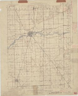
![Danville quadrangle, Illinois-Indiana : topographic sheet [1946 reprint]](https://iiif.uits.iu.edu/iiif/2/dz011t65f%2Ffiles%2F0d88511d-4915-434c-875f-219d4a99befe/full/250,/0/default.jpg)
- Subject:
- Geographic Subject: Danville Region (Ill.), Geographic Subject: Vermillion County (Ind.), and Geographic Subject: Vermilion County (Ill.)
- Creator:
- Lloyd, W. J. (Topographer), Illinois. Department of Registration and Education, Geological Survey (U.S.), Illinois State Geological Survey, Hawkins, Geo. T. ...
- Publisher:
- Geological Survey (U.S.)
- Date Created:
- 1946
- Identifier:
- VAC3073-M-01311
- Genre:
- 15 minute topographic maps, Quadrangle maps, and Topographic maps
- Geographic Location:
- Coordinates: W0874500 W0873000 N0401500 N0400000
- Related URL:
- Catalog URL: https://iucat.iu.edu/catalog/18409392
- Abstract:
- Jno. H. Renshawe, geographer in charge , control by U.S. Lake Survey and Geo. T. Hawkins , topography by W. J. Lloyd. Edition of Nov. 1900, reprinted 1946 wi...
- Call Number:
- G4090 s62 .G4 Danville 1900 R1946
- Caption:
- Imprint: [Washington, D.C.] : Geological Survey, [1946]
- Physical Description:
- Scale: 1:62,500 and Dimensions: 45 x 42 cm or smaller
- Alternate Identifier:
- Title Control Number: a18409392
- Persistent URL:
- https://purl.dlib.indiana.edu/iudl/images/VAC3073/VAC3073-M-01311
- Provenance:
- Part of Geological Survey (U.S.). Indiana 1:62,500.
-
![Illinois-Indiana, Ridge Farm quadrangle : 15-minute series [1947 printing]](https://iiif.uits.iu.edu/iiif/2/s4656k47t%2Ffiles%2F1b742aea-c167-4972-8ac1-b0b7bb864c42/full/250,/0/default.jpg)
- Subject:
- Geographic Subject: Edgar County (Ill.) and Geographic Subject: Vermilion County (Ill.)
- Creator:
- Geological Survey (U.S.) and Illinois State Geological Survey
- Publisher:
- Geological Survey (U.S.)
- Date Created:
- 1947
- Identifier:
- VAC3073-M-01391
- Genre:
- Topographic maps, 15 minute topographic maps, and Quadrangle maps
- Geographic Location:
- Coordinates: W0874500 W0873000 N0400000 N0394500
- Related URL:
- Catalog URL: https://iucat.iu.edu/catalog/18413964
- Abstract:
- Mapped by the Geological Survey. Filing title: Ridge Farm, Ill.-Ind. Edition of 1947. Polyconic projection. Relief shown by contours and spot heights. Contou...
- Call Number:
- G4090 s62 .G4 Ridge Farm 1947
- Caption:
- Imprint: [Washington, D.C.] : U.S. Geological Survey, [1947]
- Physical Description:
- Scale: 1:62,500 and Dimensions: 45 x 42 cm or smaller
- Alternate Identifier:
- Title Control Number: a18413964
- Persistent URL:
- https://purl.dlib.indiana.edu/iudl/images/VAC3073/VAC3073-M-01391
- Provenance:
- Part of Geological Survey (U.S.). Indiana 1:62,500.
