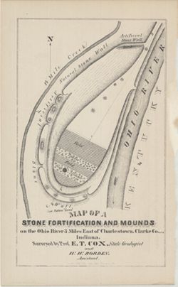
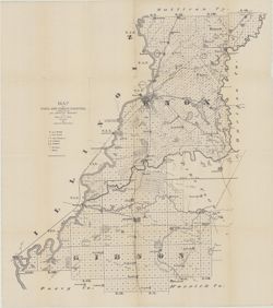
Surveyed by Prof. E. T. Cox and W. W. Borden. Pictorial map showing natural and artificial stone walls surrounding fields, timber, and mounds between the Ohi...
Call Number:
G4093.C4R4 1873 .C69
Caption:
Imprint: Indianapolis : Braden & Burford, Steam Lith., [1873] and Imprint: [Indianapolis] : [Geological Survey of Indiana], [1874]
Physical Description:
Dimensions: on sheet 22 x 14 cm and Scale: Scale not given.
Alternate Identifier:
Title Control Number: a18318556 and Alternate ID: 390723IP
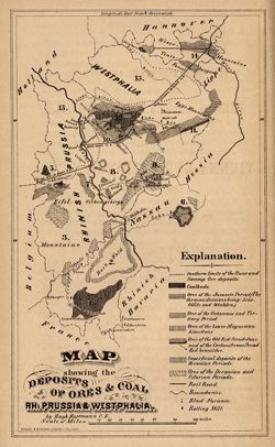
Other title: Map showing the deposits of ores and coal in Rhineland Prussia and Westphalia. Shows coal beds and ore deposits by period as well as railroads, ...
Call Number:
G6361.H1 1873 .H3
Caption:
Imprint: [Indianapolis] [Geological Survey of Indiana], [1873]
Physical Description:
Scale: Approximately 1:3,352,800 and Dimensions: 18 x 11 cm
Alternate Identifier:
Alternate ID: 390723IP and Title Control Number: a18422455
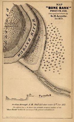
Geographic Subject: Bone Bank Site (Ind.), Topical Subject: IGS Annual Reports, Geographic Subject: Posey County (Ind.), Topical Subject: Mississippian cultu...
1 map and 1 section on 1 sheet. Surveyed and drawn by G.M. Levette Nov. 1873. Shows the "probable western outline of the 'Bone Bank' within the ...
Call Number:
G4093.P6E15 1873 .L48
Caption:
Imprint: Inds. : Braden & Burford Steam Lith. [1874] and Imprint: [Indianapolis] : [Geological Survey of Indiana], [1874]
Physical Description:
Scale: Not drawn to scale. and Dimensions: on sheet 20 x 12 cm
Alternate Identifier:
Alternate ID: 390723IP and Title Control Number: a18308000
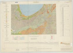
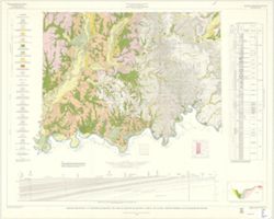
By Allan F. Schneider and Stanley J. Keller. Transverse Mercator projection. "Indiana Geological Survey in cooperation with Illinois State Geological Su...
Topical Subject: Geology, Economic, Geographic Subject: Sullivan County (Ind.), Topical Subject: Mines and mineral resources, and Topical Subject: IGS Annual...
Creator:
Collett, John, 1828-1899, Levette, G. M. (Gilbert M.), and Cox, E. T. (Edward Travers), 1821-1907
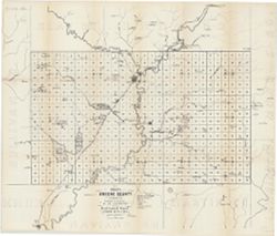
Drawn by G.M. Levette, for the second annual report of Prof. E.T. Cox, state geologist , geology by John Collett. "Braden & Burford, Lith., Indianap...
Call Number:
QE109 .A2 1870 map Sullivan
Caption:
Imprint: Indianapolis, Ind. : Geological Survey of Indiana, [1871]
Physical Description:
Scale: Approximately 1:85,000 and Dimensions: on sheet 82 x 64 cm
Alternate Identifier:
Alternate ID: 390721IP and Title Control Number: a18283359
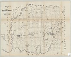
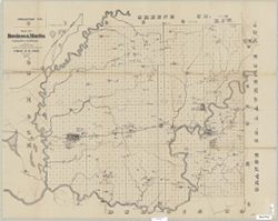
Drawn by G.M. Levette for the second annual report of Prof. E.T. Cox, state geologist , [geology by John Collett]. Shows worked coal, coal outcrops, iron ore...
Call Number:
G4093.D2H1 1870 .L4
Caption:
Imprint: Indianapolis, Ind. : Geological Survey of Indiana, [1871]
Physical Description:
Scale: Approximately 1:85,000 and Dimensions: on sheet 63 x 79 cm
Alternate Identifier:
Title Control Number: a18282530 and Alternate ID: 390721IP
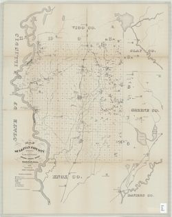
Shows towns, railroads, coal and iron ore, mills, furnaces, and stone quarries. "For the first annual report of Prof. E.T. Cox, State Geologist." ...
Call Number:
G4093.G7H1 1869 .L3
Caption:
Imprint: [Indianapolis] : [Alexander M. Conner], [1869]
Physical Description:
Dimensions: 61 x 71 cm and Scale: Approximately 1:85,000
Drawn by G.M. Levette for the second annual report of Prof. E.T. Cox, state geologist , [geology by John Collett]. Shows worked coal, coal outcrops, iron ore...
Call Number:
G4093.D2H1 1870 .L4
Caption:
Imprint: Indianapolis, Ind. : Geological Survey of Indiana, [1871]
Physical Description:
Scale: Approximately 1:85,000 and Dimensions: on sheet 63 x 79 cm
Alternate Identifier:
Alternate ID: 390721IP and Title Control Number: a18282530
Gray, Henry Hamilton, 1922-, Wier, Charles E. (Charles Eugene), 1921-, Indiana. Geological Survey, Wayne, William J. (William John), 1922-, and Illinois Stat...
Publisher:
Indiana. Geological Survey
Date Created:
1970
Identifier:
VAC3073-M-01257
Genre:
Quadrangle maps, Geological maps, and Geological cross-sections
By Henry H. Gray, William J. Wayne, and Charles E. Wier , Indiana Geological Survey, in cooperation with Illinois State Geological Survey. Transverse Mercato...