
Search Constraints
« Previous |
1 - 100 of 1,113
|
Next »
Search Results
-

- Date Created:
- 1941
- Rights Statement:
- http://rightsstatements.org/vocab/InC-EDU/1.0/
- Archival Instance:
- Art Work and Paintings by Hoagy Carmichael
- Abstract:
- Oil. 21 x 16.
- Call Number:
- ATM-MC2-7-1-1-3
- Persistent URL:
- http://purl.dlib.indiana.edu/iudl/images/VAC9217/VAC9217-000942
- Owning Institution:
- Archives of Traditional Music
-

- Description:
- Bob - Mexico 1941. Guest of Mexican government. Photo PAC.
- Date Created:
- 1941
- Rights Statement:
- http://rightsstatements.org/vocab/InC-EDU/1.0/
- Archival Instance:
- Africa/Misc.
- Call Number:
- RC-P-0027
- Caption:
- Bob - Mexico 1941. Guest of Mexican government. Photo PAC.
- Country:
- Mexico
- Persistent URL:
- http://purl.dlib.indiana.edu/iudl/iuk/VAE0296/VAE0296-000027
-
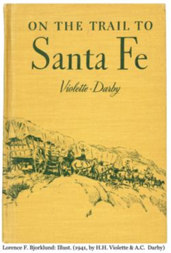
- Description:
- Cover illustrated in green on yellow/brown, covered wagon train, with line of horses, some with riders (?), in rocky terrain
- Creator:
- Bjorklund, Lorence F.
- Contributor:
- Darby, A.C. and Violette, H.H.
- Language:
- English
- Date Created:
- 1941
- Rights Statement:
- http://rightsstatements.org/vocab/NoC-US/1.0/
- Publication Place:
- Houghton Mifflin, Boston, MA
- Physical Description:
- W 13.5" x H 9.75" and Hardcover book with wrap-around illustrated cover
- Alternate Identifier:
- Lorence F. Bjorklund 98. Front
- Rights Notes:
- This work is not subject to copyright, as its copyright has not been renewed. For questions please contact Eiteljorg Museum management.
- Holding Location:
- Indianapolis - Eiteljorg Museum of American Indians and Western Art
500 West Washington Street
Indianapolis, IN 46204
Contact at 317-636-9378
-
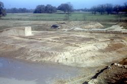
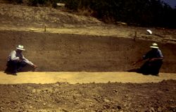
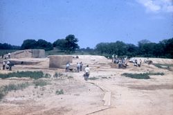
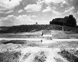
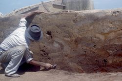
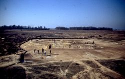
- Subject:
- Angel Mounds State Historic Site (Ind.) and Excavations (Archaeology)
- Date Created:
- 1941
- Identifier:
- VAD5943-003493
- Genre:
- Excavations & Fieldwork
- County:
- Vanderburgh
- Geographic Location:
- Site Number: 12Vg1 and Site Name: Angel Mounds
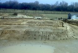
- Abstract:
- Mound F
- Call Number:
- S6570
- Caption:
- Mound F.
- Copyright Holder:
- Trustees of Indiana University
- Country:
- United States
- State/Province:
- Indiana
- Physical Description:
- 1 Slide: color, 35mm
- Persistent URL:
- http://purl.dlib.indiana.edu/iudl/gbl/VAD5943/VAD5943-003493
- Holding Location:
- Bloomington - Indiana University Museum of Archaeology and Anthropology
416 North Indiana Avenue
Bloomington, IN 47408
Contact at iumaa@indiana.edu, 812-855-6873
-
- Subject:
- Angel Mounds State Historic Site (Ind.), Excavations (Archaeology), and Photography in Archaeology
- Date Created:
- 1941
- Identifier:
- VAD5943-003490
- Genre:
- Excavations & Fieldwork
- County:
- Vanderburgh
- Geographic Location:
- Site Number: 12Vg1 and Site Name: Angel Mounds
- Abstract:
- Mound F
- Call Number:
- S6567
- Caption:
- Md F
- Copyright Holder:
- Trustees of Indiana University
- Country:
- United States
- State/Province:
- Indiana
- Physical Description:
- 1 Slide: color, 35mm
- Persistent URL:
- http://purl.dlib.indiana.edu/iudl/gbl/VAD5943/VAD5943-003490
- Holding Location:
- Bloomington - Indiana University Museum of Archaeology and Anthropology
416 North Indiana Avenue
Bloomington, IN 47408
Contact at iumaa@indiana.edu, 812-855-6873
-
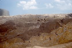
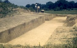
- Subject:
- Excavations (Archaeology) and Angel Mounds State Historic Site (Ind.)
- Date Created:
- 1941
- Identifier:
- VAD5943-003487
- Genre:
- Excavations & Fieldwork
- County:
- Vanderburgh
- Geographic Location:
- Site Name: Angel Mounds and Site Number: 12Vg1
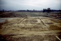
- Abstract:
- Mound F
- Call Number:
- S6564
- Caption:
- Mound F
- Copyright Holder:
- Trustees of Indiana University
- Country:
- United States
- State/Province:
- Indiana
- Physical Description:
- 1 Slide: color, 35mm
- Persistent URL:
- http://purl.dlib.indiana.edu/iudl/gbl/VAD5943/VAD5943-003487
- Holding Location:
- Bloomington - Indiana University Museum of Archaeology and Anthropology
416 North Indiana Avenue
Bloomington, IN 47408
Contact at iumaa@indiana.edu, 812-855-6873
-
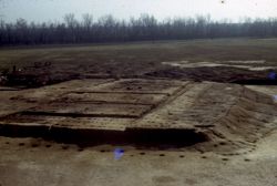
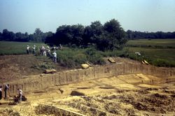
- Subject:
- Angel Mounds State Historic Site (Ind.) and Excavations (Archaeology)
- Date Created:
- 1941
- Identifier:
- VAD5943-003480
- Genre:
- Excavations & Fieldwork
- County:
- Vanderburgh
- Geographic Location:
- Site Number: 12Vg1 and Site Name: Angel Mounds
- Abstract:
- Mound F
- Call Number:
- S6547
- Caption:
- Md F
- Copyright Holder:
- Trustees of Indiana University
- Country:
- United States
- State/Province:
- Indiana
- Physical Description:
- 1 Slide: color, 35mm
- Persistent URL:
- http://purl.dlib.indiana.edu/iudl/gbl/VAD5943/VAD5943-003480
- Holding Location:
- Bloomington - Indiana University Museum of Archaeology and Anthropology
416 North Indiana Avenue
Bloomington, IN 47408
Contact at iumaa@indiana.edu, 812-855-6873
-
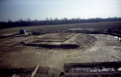
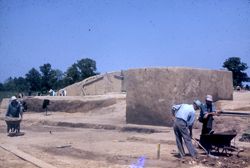
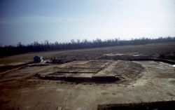
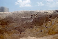
- Subject:
- Angel Mounds State Historic Site (Ind.) and Excavations (Archaeology)
- Date Created:
- 1941
- Identifier:
- VAD5943-003494
- Genre:
- Excavations & Fieldwork
- County:
- Vanderburgh
- Geographic Location:
- Site Number: 12Vg1 and Site Name: Angel Mounds
- Abstract:
- Mound F
- Call Number:
- S6571
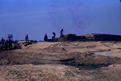
- Caption:
- Angel Site 1941- Mound F in Process of Excavation
- Copyright Holder:
- Trustees of Indiana University
- Country:
- United States
- State/Province:
- Indiana
- Physical Description:
- 1 Slide: color, 35mm
- Persistent URL:
- http://purl.dlib.indiana.edu/iudl/gbl/VAD5943/VAD5943-003494
- Holding Location:
- Bloomington - Indiana University Museum of Archaeology and Anthropology
416 North Indiana Avenue
Bloomington, IN 47408
Contact at iumaa@indiana.edu, 812-855-6873
-
- Subject:
- Excavations (Archaeology) and Angel Mounds State Historic Site (Ind.)
- Date Created:
- 1941
- Identifier:
- VAD5943-003496
- Genre:
- Excavations & Fieldwork
- County:
- Vanderburgh
- Geographic Location:
- Site Number: 12Vg1 and Site Name: Angel Mounds
- Abstract:
- Mound F
- Call Number:
- S6573
- Caption:
- Mound F-Excav. Angel
- Copyright Holder:
- Trustees of Indiana University
- Country:
- United States
- State/Province:
- Indiana
- Physical Description:
- 1 Slide: color, 35mm
- Persistent URL:
- http://purl.dlib.indiana.edu/iudl/gbl/VAD5943/VAD5943-003496
- Holding Location:
- Bloomington - Indiana University Museum of Archaeology and Anthropology
416 North Indiana Avenue
Bloomington, IN 47408
Contact at iumaa@indiana.edu, 812-855-6873
-
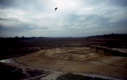
- Subject:
- Excavations (Archaeology) and Angel Mounds State Historic Site (Ind.)
- Date Created:
- 1941
- Identifier:
- VAD5943-005414
- Genre:
- Excavations & Fieldwork
- County:
- Vanderburgh
- Geographic Location:
- Site Name: Angel Mounds and Site Number: 12Vg1
- Abstract:
- Mound F
- Call Number:
- S6546
- Caption:
- Md F
- Copyright Holder:
- Trustees of Indiana University
- Country:
- United States
- State/Province:
- Indiana
- Physical Description:
- 1 Slide: color, 35mm
- Persistent URL:
- http://purl.dlib.indiana.edu/iudl/gbl/VAD5943/VAD5943-005414
- Holding Location:
- Bloomington - Indiana University Museum of Archaeology and Anthropology
416 North Indiana Avenue
Bloomington, IN 47408
Contact at iumaa@indiana.edu, 812-855-6873
-

- Subject:
- Excavations (Archaeology) and Angel Mounds State Historic Site (Ind.)
- Date Created:
- 1941
- Identifier:
- VAD5943-003483
- Genre:
- Excavations & Fieldwork
- County:
- Vanderburgh
- Geographic Location:
- Site Name: Angel Mounds and Site Number: 12Vg1
- Abstract:
- Mound F
- Call Number:
- S6553
- Caption:
- Md F
- Copyright Holder:
- Trustees of Indiana University
- Country:
- United States
- State/Province:
- Indiana
- Physical Description:
- 1 Slide: color, 35mm
- Persistent URL:
- http://purl.dlib.indiana.edu/iudl/gbl/VAD5943/VAD5943-003483
- Holding Location:
- Bloomington - Indiana University Museum of Archaeology and Anthropology
416 North Indiana Avenue
Bloomington, IN 47408
Contact at iumaa@indiana.edu, 812-855-6873
-
- Subject:
- Angel Mounds State Historic Site (Ind.) and Excavations (Archaeology)
- Date Created:
- 1941
- Identifier:
- VAD5943-003489
- Genre:
- Excavations & Fieldwork
- County:
- Vanderburgh
- Geographic Location:
- Site Number: 12Vg1 and Site Name: Angel Mounds
- Abstract:
- Mound F
- Call Number:
- S6566
- Caption:
- Md. F
- Copyright Holder:
- Trustees of Indiana University
- Country:
- United States
- State/Province:
- Indiana
- Physical Description:
- 1 Slide: color, 35mm
- Persistent URL:
- http://purl.dlib.indiana.edu/iudl/gbl/VAD5943/VAD5943-003489
- Holding Location:
- Bloomington - Indiana University Museum of Archaeology and Anthropology
416 North Indiana Avenue
Bloomington, IN 47408
Contact at iumaa@indiana.edu, 812-855-6873
-
- Subject:
- Excavations (Archaeology) and Angel Mounds State Historic Site (Ind.)
- Date Created:
- 1941
- Identifier:
- VAD5943-003495
- Genre:
- Excavations & Fieldwork
- County:
- Vanderburgh
- Geographic Location:
- Site Name: Angel Mounds and Site Number: 12Vg1
- Abstract:
- Mound F
- Call Number:
- S6572
- Caption:
- Mound F
- Copyright Holder:
- Trustees of Indiana University
- Country:
- United States
- State/Province:
- Indiana
- Physical Description:
- 1 Slide: color, 35mm
- Persistent URL:
- http://purl.dlib.indiana.edu/iudl/gbl/VAD5943/VAD5943-003495
- Holding Location:
- Bloomington - Indiana University Museum of Archaeology and Anthropology
416 North Indiana Avenue
Bloomington, IN 47408
Contact at iumaa@indiana.edu, 812-855-6873
-
- Subject:
- Excavations (Archaeology) and Angel Mounds State Historic Site (Ind.)
- Date Created:
- 1941
- Identifier:
- VAD5943-003481
- Genre:
- Excavations & Fieldwork
- County:
- Vanderburgh
- Geographic Location:
- Site Name: Angel Mounds and Site Number: 12Vg1
- Abstract:
- Mound F
- Call Number:
- S6549
- Caption:
- Md F
- Copyright Holder:
- Trustees of Indiana University
- Country:
- United States
- State/Province:
- Indiana
- Physical Description:
- 1 Slide: color, 35mm
- Persistent URL:
- http://purl.dlib.indiana.edu/iudl/gbl/VAD5943/VAD5943-003481
- Holding Location:
- Bloomington - Indiana University Museum of Archaeology and Anthropology
416 North Indiana Avenue
Bloomington, IN 47408
Contact at iumaa@indiana.edu, 812-855-6873
-
- Subject:
- Angel Mounds State Historic Site (Ind.) and Excavations (Archaeology)
- Date Created:
- 1941
- Identifier:
- VAD5943-003491
- Genre:
- Excavations & Fieldwork
- County:
- Vanderburgh
- Geographic Location:
- Site Number: 12Vg1 and Site Name: Angel Mounds
- Abstract:
- Mound F
- Call Number:
- S6568
- Copyright Holder:
- Trustees of Indiana University
- Country:
- United States
- State/Province:
- Indiana
- Physical Description:
- 1 Slide: color, 35mm
- Persistent URL:
- http://purl.dlib.indiana.edu/iudl/gbl/VAD5943/VAD5943-003491
- Holding Location:
- Bloomington - Indiana University Museum of Archaeology and Anthropology
416 North Indiana Avenue
Bloomington, IN 47408
Contact at iumaa@indiana.edu, 812-855-6873
-
- Subject:
- Angel Mounds State Historic Site (Ind.) and Excavations (Archaeology)
- Date Created:
- 1941
- Identifier:
- VAD5943-003484
- Genre:
- Excavations & Fieldwork
- County:
- Vanderburgh
- Geographic Location:
- Site Number: 12Vg1 and Site Name: Angel Mounds
- Abstract:
- Mound F
- Call Number:
- S6561
- Caption:
- Angel-Md. F
- Copyright Holder:
- Trustees of Indiana University
- Country:
- United States
- State/Province:
- Indiana
- Physical Description:
- 1 Slide: color, 35mm
- Persistent URL:
- http://purl.dlib.indiana.edu/iudl/gbl/VAD5943/VAD5943-003484
- Holding Location:
- Bloomington - Indiana University Museum of Archaeology and Anthropology
416 North Indiana Avenue
Bloomington, IN 47408
Contact at iumaa@indiana.edu, 812-855-6873
-
- Subject:
- Angel Mounds State Historic Site (Ind.) and Excavations (Archaeology)
- Date Created:
- 1941
- Identifier:
- VAD5943-003499
- Genre:
- Excavations & Fieldwork
- County:
- Vanderburgh
- Geographic Location:
- Site Number: 12Vg1 and Site Name: Angel Mounds
- Abstract:
- Mound F
- Call Number:
- S6576
- Caption:
- Angel Md. F
- Copyright Holder:
- Trustees of Indiana University
- Country:
- United States
- State/Province:
- Indiana
- Physical Description:
- 1 Slide: color, 35mm
- Persistent URL:
- http://purl.dlib.indiana.edu/iudl/gbl/VAD5943/VAD5943-003499
- Holding Location:
- Bloomington - Indiana University Museum of Archaeology and Anthropology
416 North Indiana Avenue
Bloomington, IN 47408
Contact at iumaa@indiana.edu, 812-855-6873
-
- Subject:
- Excavations (Archaeology) and Angel Mounds State Historic Site (Ind.)
- Date Created:
- 1941
- Identifier:
- VAD5943-003492
- Genre:
- Excavations & Fieldwork
- County:
- Vanderburgh
- Geographic Location:
- Site Number: 12Vg1 and Site Name: Angel Mounds
- Abstract:
- Mound F
- Call Number:
- S6569
- Caption:
- Md. F 24
- Copyright Holder:
- Trustees of Indiana University
- Country:
- United States
- State/Province:
- Indiana
- Physical Description:
- 1 Slide: color, 35mm
- Persistent URL:
- http://purl.dlib.indiana.edu/iudl/gbl/VAD5943/VAD5943-003492
- Holding Location:
- Bloomington - Indiana University Museum of Archaeology and Anthropology
416 North Indiana Avenue
Bloomington, IN 47408
Contact at iumaa@indiana.edu, 812-855-6873
-
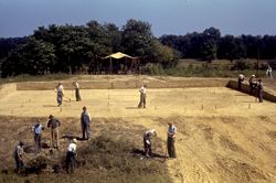
- Subject:
- Portraits, Group, Excavations (Archaeology), Mounds State Park (Ind.), and Angel Mounds State Historic Site (Ind.)
- Date Created:
- 1941
- Identifier:
- VAD5943-003500
- Genre:
- Excavations & Fieldwork and People & Institutions
- County:
- Vanderburgh
- Geographic Location:
- Site Number: 12Vg1 and Site Name: Angel Mounds
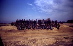
- Abstract:
- Group photo of 1941 WPA crew on Mound F
- Call Number:
- S6577
- Caption:
- Md F
- Copyright Holder:
- Trustees of Indiana University
- Country:
- United States
- State/Province:
- Indiana
- Physical Description:
- 1 Slide: color, 35mm
- Persistent URL:
- http://purl.dlib.indiana.edu/iudl/gbl/VAD5943/VAD5943-003500
- Holding Location:
- Bloomington - Indiana University Museum of Archaeology and Anthropology
416 North Indiana Avenue
Bloomington, IN 47408
Contact at iumaa@indiana.edu, 812-855-6873
-
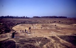
- Subject:
- Angel Mounds State Historic Site (Ind.) and Excavations (Archaeology)
- Date Created:
- 1941
- Identifier:
- VAD5943-001698
- Genre:
- Excavations & Fieldwork
- County:
- Vanderburgh
- Geographic Location:
- Site Name: Angel Mounds and Site Number: 12Vg1
- Abstract:
- Mound F excavation
- Call Number:
- N4325
- Caption:
- Copy Of P6/Md.F #2079
- Copyright Holder:
- Trustees of Indiana University
- Country:
- United States
- State/Province:
- Indiana
- Physical Description:
- 1 Negative: b&w, 4 x 5 in.
- Persistent URL:
- http://purl.dlib.indiana.edu/iudl/gbl/VAD5943/VAD5943-001698
- Holding Location:
- Bloomington - Indiana University Museum of Archaeology and Anthropology
416 North Indiana Avenue
Bloomington, IN 47408
Contact at iumaa@indiana.edu, 812-855-6873
-
- Subject:
- Excavations (Archaeology) and Angel Mounds State Historic Site (Ind.)
- Date Created:
- 1941
- Identifier:
- VAD5943-003486
- Genre:
- Excavations & Fieldwork
- County:
- Vanderburgh
- Geographic Location:
- Site Name: Angel Mounds and Site Number: 12Vg1
- Abstract:
- Mound F
- Call Number:
- S6563
- Caption:
- Angel
- Copyright Holder:
- Trustees of Indiana University
- Country:
- United States
- State/Province:
- Indiana
- Physical Description:
- 1 Slide: color, 35mm
- Persistent URL:
- http://purl.dlib.indiana.edu/iudl/gbl/VAD5943/VAD5943-003486
- Holding Location:
- Bloomington - Indiana University Museum of Archaeology and Anthropology
416 North Indiana Avenue
Bloomington, IN 47408
Contact at iumaa@indiana.edu, 812-855-6873
-
- Subject:
- Angel Mounds State Historic Site (Ind.) and Excavations (Archaeology)
- Date Created:
- 1941
- Identifier:
- VAD5943-003497
- Genre:
- Excavations & Fieldwork
- County:
- Vanderburgh
- Geographic Location:
- Site Number: 12Vg1 and Site Name: Angel Mounds
- Abstract:
- Mound F
- Call Number:
- S6574
- Copyright Holder:
- Trustees of Indiana University
- Country:
- United States
- State/Province:
- Indiana
- Physical Description:
- 1 Slide: color, 35mm
- Persistent URL:
- http://purl.dlib.indiana.edu/iudl/gbl/VAD5943/VAD5943-003497
- Holding Location:
- Bloomington - Indiana University Museum of Archaeology and Anthropology
416 North Indiana Avenue
Bloomington, IN 47408
Contact at iumaa@indiana.edu, 812-855-6873
-
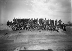
- Subject:
- Portraits, Group and Angel Mounds State Historic Site (Ind.)
- Date Created:
- 1941
- Identifier:
- VAD5943-002681
- Genre:
- Excavations & Fieldwork and People & Institutions
- County:
- Vanderburgh
- Geographic Location:
- Site Number: 12Vg1 and Site Name: Angel Mounds
- Abstract:
- 1941 Field Crew at Angel Mounds.
- Call Number:
- N2147
- Caption:
- Md.F/14 11-21-41 Field Crew Of This Date
- Copyright Holder:
- Trustees of Indiana University
- Country:
- United States
- State/Province:
- Indiana
- Physical Description:
- 1 Negative: b&w, 5 x 7 in.
- Persistent URL:
- http://purl.dlib.indiana.edu/iudl/gbl/VAD5943/VAD5943-002681
- Holding Location:
- Bloomington - Indiana University Museum of Archaeology and Anthropology
416 North Indiana Avenue
Bloomington, IN 47408
Contact at iumaa@indiana.edu, 812-855-6873
-
- Subject:
- Excavations (Archaeology) and Angel Mounds State Historic Site (Ind.)
- Date Created:
- 1941
- Identifier:
- VAD5943-003485
- Genre:
- Excavations & Fieldwork
- County:
- Vanderburgh
- Geographic Location:
- Site Name: Angel Mounds and Site Number: 12Vg1
- Abstract:
- Mound F
- Call Number:
- S6562
- Caption:
- Mound F. 24
- Copyright Holder:
- Trustees of Indiana University
- Country:
- United States
- State/Province:
- Indiana
- Physical Description:
- 1 Slide: color, 35mm
- Persistent URL:
- http://purl.dlib.indiana.edu/iudl/gbl/VAD5943/VAD5943-003485
- Holding Location:
- Bloomington - Indiana University Museum of Archaeology and Anthropology
416 North Indiana Avenue
Bloomington, IN 47408
Contact at iumaa@indiana.edu, 812-855-6873
-
- Subject:
- Excavations (Archaeology) and Angel Mounds State Historic Site (Ind.)
- Date Created:
- 1941
- Identifier:
- VAD5943-003482
- Genre:
- Excavations & Fieldwork
- County:
- Vanderburgh
- Geographic Location:
- Site Name: Angel Mounds and Site Number: 12Vg1
- Abstract:
- Mound F
- Call Number:
- S6550
- Caption:
- Md F
- Copyright Holder:
- Trustees of Indiana University
- Country:
- United States
- State/Province:
- Indiana
- Physical Description:
- 1 Slide: color, 35mm
- Persistent URL:
- http://purl.dlib.indiana.edu/iudl/gbl/VAD5943/VAD5943-003482
- Holding Location:
- Bloomington - Indiana University Museum of Archaeology and Anthropology
416 North Indiana Avenue
Bloomington, IN 47408
Contact at iumaa@indiana.edu, 812-855-6873
-
- Subject:
- Angel Mounds State Historic Site (Ind.) and Excavations (Archaeology)
- Date Created:
- 1941
- Identifier:
- VAD5943-003498
- Genre:
- Excavations & Fieldwork
- County:
- Vanderburgh
- Geographic Location:
- Site Number: 12Vg1 and Site Name: Angel Mounds
- Abstract:
- Mound F
- Call Number:
- S6575
- Caption:
- Angel Md. F
- Copyright Holder:
- Trustees of Indiana University
- Country:
- United States
- State/Province:
- Indiana
- Physical Description:
- 1 Slide: color, 35mm
- Persistent URL:
- http://purl.dlib.indiana.edu/iudl/gbl/VAD5943/VAD5943-003498
- Holding Location:
- Bloomington - Indiana University Museum of Archaeology and Anthropology
416 North Indiana Avenue
Bloomington, IN 47408
Contact at iumaa@indiana.edu, 812-855-6873
-

- Subject:
- Topical: Graves
- Series:
- Groups
- Creator:
- Montgomery, Pauline
- Date Created:
- 1941
- Identifier:
- VAE0886-001976
- Geographic Location:
- Riverside Cemetery
- Abstract:
- There is no image for this record.
- Caption:
- Ledger Page/ Entry Number: 142/5, Personal Name, Age/Gender: huddleston, Mary Jane Fury, -/F, Donor's Image Number: None, and Death Date: 1941
- City:
- Cambridge City
- Copyright Holder:
- Indiana University
- Country:
- United States
- State/Province:
- Indiana
- Alternate Identifier:
- C386
- Persistent URL:
- http://purl.dlib.indiana.edu/iudl/archives/VAE0886/VAE0886-001976
- Holding Location:
- Bloomington - University Archives
Wells Library E460
1320 E 10th St.
Bloomington, IN 47405
Contact at archives@indiana.edu, 812-855-1127
-
- Subject:
- Topical: Graves
- Series:
- Groups
- Creator:
- Montgomery, Pauline
- Date Created:
- 1941
- Identifier:
- VAE0886-001974
- Geographic Location:
- Riverside Cemetery
- Abstract:
- There is no image for this record.
- Caption:
- Personal Name, Age/Gender: Huddleston, Rollin M., -/M, Personal Name, Age/Gender: Huddleston, Mary Jane Fury, -/F, Ledger Page/ Entry Number: 142/3, Donor...
- City:
- Cambridge City
- Copyright Holder:
- Indiana University
- Country:
- United States
- State/Province:
- Indiana
- Alternate Identifier:
- C386
- Persistent URL:
- http://purl.dlib.indiana.edu/iudl/archives/VAE0886/VAE0886-001974
- Holding Location:
- Bloomington - University Archives
Wells Library E460
1320 E 10th St.
Bloomington, IN 47405
Contact at archives@indiana.edu, 812-855-1127
-
- Subject:
- Topical: Graves
- Series:
- Groups
- Creator:
- Montgomery, Pauline
- Date Created:
- 1941
- Identifier:
- VAE0886-001975
- Geographic Location:
- Riverside Cemetery
- Abstract:
- There is no image for this record.
- Caption:
- Death Date: 1941, Donor's Image Number: None, Personal Name, Age/Gender: Huddleston, Rollin M., -/M, and Ledger Page/ Entry Number: 142/4
- City:
- Cambridge City
- Copyright Holder:
- Indiana University
- Country:
- United States
- State/Province:
- Indiana
- Alternate Identifier:
- C386
- Persistent URL:
- http://purl.dlib.indiana.edu/iudl/archives/VAE0886/VAE0886-001975
- Holding Location:
- Bloomington - University Archives
Wells Library E460
1320 E 10th St.
Bloomington, IN 47405
Contact at archives@indiana.edu, 812-855-1127
-
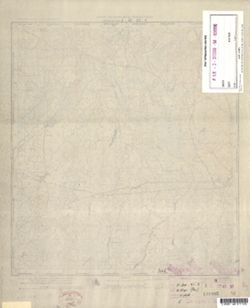
![Kentucky-Indiana Cannelton quadrangle [1941 reprint]](https://iiif.uits.iu.edu/iiif/2/8336j442q%2Ffiles%2F47a90ccc-f6f3-4558-aeaf-5356b28b815d/full/250,/0/default.jpg)
- Subject:
- Geographic Subject: Breckinridge County (Ky.) and Geographic Subject: Hancock County (Ind.)
- Creator:
- United States. Army. Corps of Engineers, Tull, L. E. (Lawrence Emerson), 1894-1987, Higginson, W. S. (William Smith Muir), 1894-1984, and Runyan, R. H.
- Publisher:
- Geological Survey (U.S.)
- Date Created:
- 1941
- Identifier:
- VAC3073-M-01326
- Genre:
- Quadrangle maps, Topographic maps, and 15 minute topographic maps
- Geographic Location:
- Coordinates: W0864500 W0863000 N0380000 N0374500
- Related URL:
- Catalog URL: https://iucat.iu.edu/catalog/18415999
- Abstract:
- Topography by R.H. Runyan, W.S. Higginson, and L.E. Tull , Ohio River by Corps of Engineers, U.S. Army. Polyconic projection. Relief shown by contours and sp...
- Call Number:
- G4090 s62 .G4 Cannelton 1934 rep1941
- Caption:
- Imprint: Washington, D.C. : Dept. of the Interior, U.S. Geological Survey, 1941
- Physical Description:
- Dimensions: 45 x 42 cm or smaller and Scale: 1:62,500
- Alternate Identifier:
- Title Control Number: a18415999
- Persistent URL:
- https://purl.dlib.indiana.edu/iudl/images/VAC3073/VAC3073-M-01326
- Provenance:
- Part of Geological Survey (U.S.). Indiana 1:62,500.
-
![Jackson County [Indiana] land use map [map] : preliminary](https://iiif.uits.iu.edu/iiif/2/b27750001%2Ffiles%2F79afb54a-ede0-4189-97ab-813c27a4f6d8/full/250,/0/default.jpg)
- Subject:
- Geographic Subject: Jackson County (Ind.) and Topical Subject: Land use
- Creator:
- Jackson County (Ind.). Land Use Planning Committee
- Publisher:
- Jackson County (Ind.). Land Use Planning Committee
- Date Created:
- 1941
- Identifier:
- VAC3073-M-00813
- Genre:
- Thematic maps
- Geographic Location:
- Coordinates: W0861905 W0854742 N0390416 N0384330
- Related URL:
- Catalog URL: https://iucat.iu.edu/catalog/4989649
- Abstract:
- Includes chart showing type of land use, acreage, and recommended use.
- Call Number:
- G4093.J2 G4 1941 .J33
- Caption:
- Imprint: [Brownstown, Ind.?] : The Committee, [between 1941-1946?]
- Physical Description:
- Dimensions: 21 x 24 cm, on sheet 39 x 28 cm and Scale: Scale not given.
- Alternate Identifier:
- Title Control Number: a4989649
- Persistent URL:
- https://purl.dlib.indiana.edu/iudl/images/VAC3073/VAC3073-M-00813
-
![Gibson County [Indiana] preliminary land use map](https://iiif.uits.iu.edu/iiif/2/f7624g240%2Ffiles%2F91ddcfae-bfc8-40ae-a801-4b23f126742f/full/250,/0/default.jpg)
- Subject:
- Topical Subject: Land use and Geographic Subject: Gibson County (Ind.)
- Creator:
- Gibson County (Ind.). Land Use Planning Committee
- Publisher:
- United States. Bureau of Agricultural Economics
- Date Created:
- 1941
- Identifier:
- VAC3073-M-00705
- Genre:
- Thematic maps
- Geographic Location:
- Coordinates: W0875917 W0871856 N0383200 N0380955
- Related URL:
- Catalog URL: https://iucat.iu.edu/catalog/5126313
- Abstract:
- "Color reproduction by Bureau of Agricultural Economics, U.S.D.A." "7-31-41". Includes chart showing type of land use, acreage, and recom...
- Call Number:
- G4093.G5G4 1941 .G53
- Caption:
- Imprint: [Washington, D.C.?] : U.S. Bureau of Agricultural Economics, [1941]
- Physical Description:
- Dimensions: 18 x 26 cm, on sheet 38 x 28 cm and Scale: Scale not given.
- Alternate Identifier:
- Title Control Number: a5126313
- Persistent URL:
- https://purl.dlib.indiana.edu/iudl/images/VAC3073/VAC3073-M-00705
-
![Kentucky-Indiana Uniontown quadrangle [1941 reprint without vegetation]](https://iiif.uits.iu.edu/iiif/2/rx914s94d%2Ffiles%2Fb75fcf05-19c0-4df9-9bed-49261c5f07c0/full/250,/0/default.jpg)
- Subject:
- Geographic Subject: Henderson County (Ky.), Geographic Subject: Posey County (Ind.), and Geographic Subject: Union County (Ky.)
- Creator:
- Gehres, W. S. (Wilmer Sherman), 1887-1963, Goodlove, C. W., U.S. Coast and Geodetic Survey, Ellis, J. R. (Topographer), Geological Survey (U.S.), Herrington,...
- Publisher:
- Geological Survey (U.S.)
- Date Created:
- 1941
- Identifier:
- VAC3073-M-01403
- Genre:
- Quadrangle maps, Topographic maps, and 15 minute topographic maps
- Geographic Location:
- Coordinates: W0880000 W0874500 N0380000 N0374500
- Related URL:
- Catalog URL: https://iucat.iu.edu/catalog/18415442
- Abstract:
- R.B. Marshall, chief geographer , W.H. Herron, geographer in charge , topography by C.W. Goodlove, R.M. Herrington and W.S. Gehres , control by U.S. Coast an...
- Call Number:
- G4090 s62 .G4 Uniontown 1917 rep1941
- Caption:
- Imprint: [Washington, D.C.] : U.S. Geological Survey, 1941
- Physical Description:
- Dimensions: 45 x 42 cm or smaller and Scale: 1:62,500
- Alternate Identifier:
- Title Control Number: a18415442
- Persistent URL:
- https://purl.dlib.indiana.edu/iudl/images/VAC3073/VAC3073-M-01403
- Provenance:
- Part of Geological Survey (U.S.). Indiana 1:62,500.
-
![Kentucky-Indiana Uniontown quadrangle [1941 reprint without vegetation]](https://iiif.uits.iu.edu/iiif/2/4m90fx89j%2Ffiles%2Fc2e137b5-4791-4eaa-a234-4e491cea321e/full/250,/0/default.jpg)
- Subject:
- Geographic Subject: Henderson County (Ky.), Geographic Subject: Posey County (Ind.), and Geographic Subject: Union County (Ky.)
- Creator:
- Kentucky Geological Survey, Marshall, R. B. (Robert Bradford), 1867-1949, Herrington, R. M. (Russell McKee), 1890-1977, U.S. Coast and Geodetic Survey, Hawki...
- Publisher:
- Geological Survey (U.S.)
- Date Created:
- 1941
- Identifier:
- VAC3073-M-01336
- Genre:
- Quadrangle maps, Topographic maps, and 15 minute topographic maps
- Geographic Location:
- Coordinates: W0880000 W0874500 N0380000 N0374500
- Related URL:
- Catalog URL: https://iucat.iu.edu/catalog/18415442
- Abstract:
- R.B. Marshall, chief geographer , W.H. Herron, geographer in charge , topography by C.W. Goodlove, R.M. Herrington and W.S. Gehres , control by U.S. Coast an...
- Call Number:
- G4090 s62 .G4 Uniontown 1917 rep 1941
- Caption:
- Imprint: [Washington, D.C.] : U.S. Geological Survey, 1941.
- Physical Description:
- Dimensions: 45 x 42 cm or smaller and Scale: 1:62,500
- Alternate Identifier:
- Title Control Number: a18415442
- Persistent URL:
- https://purl.dlib.indiana.edu/iudl/images/VAC3073/VAC3073-M-01336
- Provenance:
- Part of Geological Survey (U.S.). Indiana 1:62,500.
-
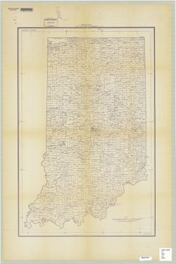
- Subject:
- Topical Subject: Landowners, Topical Subject: Real property, and Geographic Subject: Montgomery County (Ind.)
- Creator:
- Donica, Roy E.
- Publisher:
- Roy E. Donica and Karl M. Laurimore
- Date Created:
- 1941
- Identifier:
- VAC3073-M-00217
- Genre:
- Cadastral maps
- Geographic Location:
- Coordinates: W0870600 W0864200 N0401300 N0395200
- Related URL:
- Catalog URL: https://iucat.iu.edu/catalog/5383100
- Abstract:
- Cadastral map showing landowners. "1940-1941."
- Call Number:
- G4093.M8 G46 1941 .D66
- Caption:
- Imprint: [Crawfordsville, Ind.] : Roy E. Donica and Karl M. Laurimore, [1941].
- Physical Description:
- Dimensions: 125 x 125 cm and Scale: 1:31,680
- Alternate Identifier:
- Title Control Number: a5383100
- Persistent URL:
- https://purl.dlib.indiana.edu/iudl/images/VAC3073/VAC3073-M-00217
-
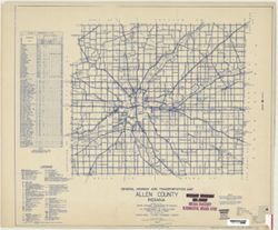
- Subject:
- Topical Subject: Roads and Geographic Subject: Adams County (Ind.)
- Creator:
- Indiana. State Highway Commission (1919-1953)
- Publisher:
- Indiana. State Highway Commission (1919-1953)
- Date Created:
- 1941
- Identifier:
- VAC3073-M-00767
- Genre:
- Road maps
- Geographic Location:
- Coordinates: W0850400 W0844800 N0405500 N0403400
- Related URL:
- Catalog URL: https://iucat.iu.edu/catalog/5726499
- Abstract:
- Blue line print. "Corrected to May 1, 1941." "Data obtained from State-wide Highway Planning Survey." Includes location map and charts &q...
- Call Number:
- G4093.A2P2 1949 .I53
- Caption:
- Imprint: [Indianapolis?] : The Commission, 1941.
- Physical Description:
- Scale: 1:63,360 and Dimensions: 89 x 104 cm
- Alternate Identifier:
- Title Control Number: a5359424
- Persistent URL:
- https://purl.dlib.indiana.edu/iudl/images/VAC3073/VAC3073-M-00767
-
![Kentucky-Indiana Prospect quadrangle [1941 reprint]](https://iiif.uits.iu.edu/iiif/2/n583zx80k%2Ffiles%2F0de7baa2-b556-4bc2-a198-4e9c9c77a358/full/250,/0/default.jpg)
- Subject:
- Geographic Subject: Oldham County (Ky.) and Geographic Subject: Jefferson County (Ky.)
- Creator:
- Smith, L. Scott, Ellis, J. R. (Topographer), Cooke, Chas. E. (Charles E.), Kentucky Geological Survey, Marshall, R. B. (Robert Bradford), 1867-1949, Herron, ...
- Publisher:
- Geological Survey (U.S.)
- Date Created:
- 1941
- Identifier:
- VAC3073-M-01389
- Genre:
- Topographic maps, Quadrangle maps, and 15 minute topographic maps
- Geographic Location:
- Coordinates: W0854500 W0853000 N0383000 N0381500
- Related URL:
- Catalog URL: https://iucat.iu.edu/catalog/18413939
- Abstract:
- R.B. Marshall, chief geographer , W.H. Herron, geographer in charge , topography by Chas. E. Cooke and L. Scott Smith , control by J.R. Ellis, C.H. Semper, a...
- Call Number:
- G4090 s62 .G4 Prospect 1912 rep1941
- Caption:
- Imprint: [Washington, D.C.] : U.S. Geological Survey, 1941
- Physical Description:
- Scale: 1:62,500 and Dimensions: 45 x 42 cm or smaller
- Alternate Identifier:
- Title Control Number: a18413939
- Persistent URL:
- https://purl.dlib.indiana.edu/iudl/images/VAC3073/VAC3073-M-01389
- Provenance:
- Part of Geological Survey (U.S.). Indiana 1:62,500.
-
![Bartholomew County [Indiana] preliminary land use map](https://iiif.uits.iu.edu/iiif/2/05742t46j%2Ffiles%2Fd91da533-b380-4311-a36b-84729f4dd8f8/full/250,/0/default.jpg)
- Subject:
- Topical Subject: Land use and Geographic Subject: Bartholomew County (Ind.)
- Creator:
- Bartholomew County (Ind.). Land Use Planning Committee
- Publisher:
- Bartholomew County (Ind.). Land Use Planning Committee
- Date Created:
- 1941
- Identifier:
- VAC3073-M-00100
- Genre:
- Maps
- Geographic Location:
- Coordinates: W0860009 W0854554 N0391818 N0390254
- Related URL:
- Catalog URL: https://iucat.iu.edu/catalog/4989660
- Abstract:
- Includes chart showing type of land use, acreage, and recommended use.
- Call Number:
- G4093.B3G4 1941 .B37
- Caption:
- Imprint: [Columbus, Ind.?] : The Committee, [between 1941-1946?]
- Physical Description:
- Scale: Scale not given. and Dimensions: 20 x 21 cm, on sheet 39 x 28 cm
- Alternate Identifier:
- Title Control Number: a4989660
- Persistent URL:
- https://purl.dlib.indiana.edu/iudl/images/VAC3073/VAC3073-M-00100
-
![Lawrence County [Indiana] land use map : preliminary](https://iiif.uits.iu.edu/iiif/2/3f4638283%2Ffiles%2F6794596b-a04d-4274-a4e6-028f8527881c/full/250,/0/default.jpg)
- Subject:
- Geographic Subject: Lawrence County (Ind.) and Topical Subject: Land use
- Creator:
- Lawrence County (Ind.). Land Use Planning Committee
- Publisher:
- Lawrence County (Ind.). Land Use Planning Committee
- Date Created:
- 1941
- Identifier:
- VAC3073-M-00787
- Genre:
- Thematic maps
- Geographic Location:
- Coordinates: W0864102 W0861631 N0385932 N0384111
- Related URL:
- Catalog URL: https://iucat.iu.edu/catalog/4989673
- Abstract:
- Includes chart, with some figures corrected by hand, showing type of land use, acreage, and recommended use.
- Call Number:
- G4093 .L5 G4 1941 .L39
- Caption:
- Imprint: [Bedford, Ind.?] : The Committee, [between 1941-1946?]
- Physical Description:
- Scale: Scale not given. and Dimensions: 23 x 23 cm, on sheet 39 x 28 cm
- Alternate Identifier:
- Title Control Number: a4989673
- Persistent URL:
- https://purl.dlib.indiana.edu/iudl/images/VAC3073/VAC3073-M-00787
-
- Subject:
- Geographic Subject: Indiana and Topical Subject: Administrative and political divisions
- Creator:
- United States. Bureau of the Census
- Publisher:
- United States. Government Printing Office
- Date Created:
- 1941
- Identifier:
- VAC3073-M-00814
- Genre:
- Thematic maps
- Geographic Location:
- Coordinates: W0880700 W0844500 N0414500 N0375200
- Related URL:
- Catalog URL: https://iucat.iu.edu/catalog/2252913
- Abstract:
- "Geo. M-12-40."
- Call Number:
- G4091 .F7 1940 .U5
- Caption:
- Imprint: Washington, D.C. : U.S.G.P.O., 1940.
- Physical Description:
- Dimensions: 94 x 61 cm and Scale: 1:500,000
- Alternate Identifier:
- Title Control Number: BGX8682BB
- Persistent URL:
- https://purl.dlib.indiana.edu/iudl/images/VAC3073/VAC3073-M-00814
-

- Description:
- 1926
- Subject:
- Geographic Subject: Balky, Topical Subject: Soviet Union, and Topical Subject: Maps
- Publisher:
- Генеральный штаб Красной Армии
- Language:
- Russian
- Date Created:
- 1941
- Identifier:
- VAC9619-001868
- Genre:
- Topographic Maps and Military Maps
- Geographic Location:
- Coordinates: 47.3333, 34.5, 47.6667, 35
- Related URL:
- Catalog URL: https://iucat.iu.edu/catalog/5020129 and Download GeoTIFF: https://drive.google.com/open?id=1V7PHm7Dg5ABV8yybrFeMKAmxM9f2EO27
- Abstract:
- Modern area represented: Balky, Zaporizhia oblast, Ukraine
- Call Number:
- G7000 s100 .S7 sheet L-36-22
- Caption:
- Для служебного пользования
- City:
- Балки (Balky)
- Copyright Holder:
- No Copyright - United States
- Country:
- СССР (USSR)
- State/Province:
- Украинская ССР (Ukrainian Soviet Socialist Republic)
- Physical Description:
- Scale: 1:100,000
- Persistent URL:
- http://purl.dlib.indiana.edu/iudl/images/VAC9619/VAC9619-001868
- Provenance:
- CIA Map Library
-

- Description:
- 1938
- Subject:
- Topical Subject: Maps, Geographic Subject: Krasnogvardeyskoe, and Topical Subject: Soviet Union
- Publisher:
- Главное управление геодезии и картографии при СНК СССР
- Language:
- Russian
- Date Created:
- 1941
- Identifier:
- VAC9619-002343
- Genre:
- Topographic Maps and Military Maps
- Geographic Location:
- Coordinates: 45.667, 41.5, 46, 42
- Related URL:
- Download GeoTIFF: https://drive.google.com/file/d/1AVr-cwCpH2TyChEw-jxKdVkFJnNQ8ff2/view?usp=sharing and Catalog URL: https://iucat.iu.edu/catalog/5020129
- Abstract:
- Modern area represented: Krasnogvardeyskoe, Stavropol kray, Russia
- Call Number:
- G7000 s100 .S7 sheet L-37-84
- Caption:
- Для служебного пользования
- City:
- Молотовское (Molotovskoe)
- Copyright Holder:
- No Copyright - United States
- Country:
- СССР (USSR)
- State/Province:
- Орджоникидзевский край (Ordzhonikidze kray), Калмыцкая АССР (Kalmyk Autonomous Soviet Socialist Republic), Ростовская область (Rostov oblast), and РСФСР (RSFSR)
- Physical Description:
- Scale: 1:100,000
- Persistent URL:
- http://purl.dlib.indiana.edu/iudl/images/VAC9619/VAC9619-002343
- Provenance:
- DMA Topographic Center, Army Map Service Library, OMAHA
-

- Description:
- 1939
- Subject:
- Topical Subject: Maps, Geographic Subject: Yukhnov, and Topical Subject: Soviet Union
- Publisher:
- Генеральный штаб Красной Армии
- Language:
- Russian
- Date Created:
- 1941
- Identifier:
- VAC9619-004187
- Genre:
- Topographic Maps and Military Maps
- Geographic Location:
- Coordinates: 54.667, 35, 55, 35.5
- Related URL:
- Download GeoTIFF: https://drive.google.com/file/d/1cQNBivSSzsjyVCwoyr6v2BrCZDWttVf4/view?usp=sharing and Catalog URL: https://iucat.iu.edu/catalog/5020129
- Abstract:
- Modern area represented: Yukhnov, Kaluga oblast, Russia
- Call Number:
- G7000 s100 .S7 sheet N-36-47
- City:
- Юхнов (Yukhnov)
- Copyright Holder:
- No Copyright - United States
- Country:
- СССР (USSR)
- State/Province:
- Смоленская область (Smolensk oblast) and РСФСР (RSFSR)
- Physical Description:
- Scale: 1:100,000
- Persistent URL:
- http://purl.dlib.indiana.edu/iudl/images/VAC9619/VAC9619-004187
- Provenance:
- DMA Topographic Center, Army Map Service Library, OMAHA
-
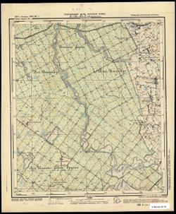
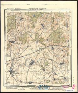
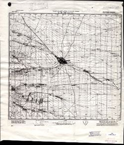
- Subject:
- Topical Subject: Soviet Union, Geographic Subject: Iskrovo, and Topical Subject: Maps
- Publisher:
- Генеральный штаб Красной Армии
- Language:
- Russian
- Date Created:
- 1941
- Identifier:
- VAC9619-003679
- Genre:
- Military Maps and Topographic Maps
- Geographic Location:
- Coordinates: 54.75, 21.375, 54.833, 21.5
- Related URL:
- Download GeoTIFF: https://drive.google.com/file/d/1yu7MH4jFLldg0pLFCOFpgBlt6_SbUA89/view?usp=sharing and Catalog URL: https://iucat.iu.edu/catalog/14701157
- Abstract:
- Modern area represented: part of Искрово (Iskrovo), Kaliningradskaya oblast, Russia
- Call Number:
- G7063.K2 s25 .S6 sheet N-34-43-D-b
- City:
- Паннауген
- Copyright Holder:
- No Copyright - United States
- Country:
- Германия (Восточная Пруссия) (Germany (East Prussia))
- Physical Description:
- Scale: 1:25,000
- Persistent URL:
- http://purl.dlib.indiana.edu/iudl/images/VAC9619/VAC9619-003679
- Provenance:
- CIA Map Branch -- Received
-

- Description:
- 1937
- Subject:
- Geographic Subject: Gummolovo and Topical Subject: Soviet Union
- Publisher:
- Главное управление государственной съемки и картографии НКВД СССР
- Language:
- Russian
- Date Created:
- 1941
- Identifier:
- VAC9619-000040
- Genre:
- Military Maps and Topographic Maps
- Geographic Location:
- Coordinates: 59.1667, 30.75, 59.3333, 31
- Related URL:
- Catalog URL: http://iucat.iu.edu/catalog/5020131 and Download GeoTIFF: https://drive.google.com/open?id=1Thglq8S3ntpZfPmHWFNFQ1QHmQpoR5Lu
- Abstract:
- Modern area represented: Gummolovo, Russia
- Call Number:
- G7000 s50 .S68 sheet O-36-26-B
- Caption:
- Для служебного пользования
- City:
- Гуммолово (Gummolovo)
- Copyright Holder:
- No Copyright - United States
- Country:
- СССР (USSR)
- State/Province:
- Ленинградская область (Leningrad oblast), Тосненский район (Tosnensky district), and РСФСР (RSFSR)
- Physical Description:
- Scale: 1:50,000
- Persistent URL:
- http://purl.dlib.indiana.edu/iudl/images/VAC9619/VAC9619-000040
- Provenance:
- Army Map Service Library, OMAHA, Library of Congress Geography & Map Division
-

- Description:
- 1933
- Subject:
- Topical Subject: Soviet Union, Geographic Subject: Taman, and Topical Subject: Maps
- Publisher:
- Генеральный штаб Красной Армии
- Language:
- Russian
- Date Created:
- 1941
- Identifier:
- VAC9619-002358
- Genre:
- Topographic Maps and Military Maps
- Geographic Location:
- Coordinates: 45, 36.5, 45.333, 37
- Related URL:
- Download GeoTIFF: https://drive.google.com/file/d/1X763anMOD-wQf-npLvv0Rk-_nGzkuqHb/view?usp=sharing and Catalog URL: https://iucat.iu.edu/catalog/5020129
- Abstract:
- Modern area represented: Taman, Russia
- Call Number:
- G7000 s100 .S7 sheet L-37-98
- Caption:
- Для служебного пользования
- City:
- Тамань (Taman)
- Copyright Holder:
- No Copyright - United States
- Country:
- СССР (USSR)
- State/Province:
- РСФСР (RSFSR) and Краснодарский край (Krasnodar kray)
- Physical Description:
- Scale: 1:100,000
- Persistent URL:
- http://purl.dlib.indiana.edu/iudl/images/VAC9619/VAC9619-002358
- Provenance:
- DMA Topographic Center, Army Map Service Library, Library of Congress Geography & Map Division
-
- Subject:
- Topical Subject: Soviet Union, Geographic Subject: Radzymin, and Topical Subject: Maps
- Publisher:
- Генеральный штаб Красной Армии
- Language:
- Russian
- Date Created:
- 1941
- Identifier:
- VAC9619-000261
- Genre:
- Topographic Maps and Military Maps
- Geographic Location:
- Coordinates: 52.3333, 21, 52.5, 21.25
- Related URL:
- Download GeoTIFF: https://drive.google.com/open?id=1MGqJ3x9il9JlEmFwvpxgnBaQh9vtG1hD and Catalog URL: http://iucat.iu.edu/catalog/5020131
- Abstract:
- Modern area represented: Radzymin, Poland
- Call Number:
- G7000 s50 .S68 sheet N-34-127-C
- Caption:
- Captured map
- City:
- Радзымин (Radzymin)
- Copyright Holder:
- No Copyright - United States
- Country:
- Область государственных интересов Германии (Region of German state interest)
- Physical Description:
- Scale: 1:50,000
- Persistent URL:
- http://purl.dlib.indiana.edu/iudl/images/VAC9619/VAC9619-000261
- Provenance:
- Army Map Service Library, Library of Congress Geography & Map Division
-
- Subject:
- Topical Subject: Soviet Union, Geographic Subject: Lipitsy, and Topical Subject: Maps
- Publisher:
- Генеральный штаб Красной Армии
- Language:
- Russian
- Date Created:
- 1941
- Identifier:
- VAC9619-003149
- Genre:
- Military Maps and Topographic Maps
- Geographic Location:
- Coordinates: 53.333, 37, 53.667, 37.5
- Related URL:
- Catalog URL: https://iucat.iu.edu/catalog/5020129 and Download GeoTIFF: https://drive.google.com/file/d/1DEJf3klsNOB3iIRfqpOPFMpm2cBBmWTF/view?usp=sharing
- Abstract:
- Modern area represented: Lipitsy, Tula oblast, Russia
- Call Number:
- G7000 s100 .S7 sheet N-37-87
- City:
- Липицы (Lipitsy)
- Copyright Holder:
- No Copyright - United States
- Country:
- СССР (USSR)
- State/Province:
- Тульская область (Tula oblast) and РСФСР (RSFSR)
- Physical Description:
- Scale: 1:100,000
- Persistent URL:
- http://purl.dlib.indiana.edu/iudl/images/VAC9619/VAC9619-003149
- Provenance:
- Army Map Service Library, Library of Congress G & M Division
-
- Description:
- 1939
- Subject:
- Geographic Subject: Lushchikovo, Topical Subject: Soviet Union, and Topical Subject: Maps
- Publisher:
- Главное Управление Геодезии и Картографии при СНК СССР
- Language:
- Russian
- Date Created:
- 1941
- Identifier:
- VAC9619-001316
- Genre:
- Topographic Maps and Military Maps
- Geographic Location:
- Coordinates: 54.667, 33.5, 54.833, 33.75
- Related URL:
- Download GeoTIFF: https://drive.google.com/open?id=1QqwkbeqMxBP_h4g_YQjctsz1Sdi9nkJC and Catalog URL: http://iucat.iu.edu/catalog/5020131
- Abstract:
- Modern area represented: Lushchikovo, Smolensk oblast, Russia
- Call Number:
- GM G7000 S50 .S68 N-36-44-C
- Copyright Holder:
- No Copyright - United States
- Country:
- СССР (USSR)
- State/Province:
- РСФСР (RSFSR) and Смоленская область (Smolensk oblast)
- Physical Description:
- Scale: 1:50,000
- Persistent URL:
- http://purl.dlib.indiana.edu/iudl/images/VAC9619/VAC9619-001316
- Provenance:
- M. I. Map Library, G000-30, CIA Map Library
-

- Description:
- 1939
- Subject:
- Topical Subject: Soviet Union, Geographic Subject: Komyshuvakha, and Topical Subject: Maps
- Publisher:
- Генеральный штаб Красной Армии
- Language:
- Russian
- Date Created:
- 1941
- Identifier:
- VAC9619-001844
- Genre:
- Military Maps and Topographic Maps
- Geographic Location:
- Coordinates: 47.6667, 35.5, 48, 36
- Related URL:
- Download GeoTIFF: https://drive.google.com/open?id=1IiavgxI6IZ79dkMzQI3jHmPsU86TTxOH and Catalog URL: https://iucat.iu.edu/catalog/5020129
- Abstract:
- Modern area represented: Komyshuvakha, Zaporizhia oblast, Ukraine
- Call Number:
- G7000 s100 .S7 sheet L-36-12
- Caption:
- Для служебного пользования
- City:
- Камышуваха (Komyshuvakha)
- Copyright Holder:
- No Copyright - United States
- Country:
- СССР (USSR)
- State/Province:
- Запорожская область (Zaporizhia oblast) and Украинская ССР (Ukrainian Soviet Socialist Republic)
- Physical Description:
- Scale: 1:100,000
- Persistent URL:
- http://purl.dlib.indiana.edu/iudl/images/VAC9619/VAC9619-001844
- Provenance:
- CIA Map Library
-

- Description:
- 1926
- Subject:
- Topical Subject: Soviet Union, Geographic Subject: Sirotskiy, and Topical Subject: Maps
- Publisher:
- Генеральный штаб Красной Армии
- Language:
- Russian
- Date Created:
- 1941
- Identifier:
- VAC9619-002461
- Genre:
- Military Maps and Topographic Maps
- Geographic Location:
- Coordinates: 47, 43, 47.333, 43.5
- Related URL:
- Download GeoTIFF: https://drive.google.com/file/d/1lKyxlwfueH8iSqR8tLrAkEEVeuu5mIWT/view?usp=sharing and Catalog URL: https://iucat.iu.edu/catalog/5020129
- Abstract:
- Modern area represented: Sirotskiy, Russia
- Call Number:
- G7000 s100 .S7 sheet L-38-27
- Caption:
- Для служебного пользования
- City:
- Сиротский (Sirotskiy)
- Copyright Holder:
- No Copyright - United States
- Country:
- СССР (USSR)
- State/Province:
- РСФСР (RSFSR) and Ростовская область (Rostov oblast)
- Physical Description:
- Scale: 1:100,000
- Persistent URL:
- http://purl.dlib.indiana.edu/iudl/images/VAC9619/VAC9619-002461
- Provenance:
- DMA Topographic Center, Army Map Service Library
-
- Description:
- 1938
- Subject:
- Topical Subject: Maps, Geographic Subject: Vasilyevo, and Topical Subject: Soviet Union
- Publisher:
- Главное Управление Геодезии и Картографии при СНК СССР
- Language:
- Russian
- Date Created:
- 1941
- Identifier:
- VAC9619-001873
- Genre:
- Military Maps and Topographic Maps
- Geographic Location:
- Coordinates: 55.1667, 36, 55.3333, 36.25
- Related URL:
- Download GeoTIFF: https://drive.google.com/open?id=1K6w6CW9dTrPwudpPrBYVpbWjdNeeC133 and Catalog URL: http://iucat.iu.edu/catalog/5020131
- Abstract:
- Modern area represented: Vasilyevo, Russia
- Call Number:
- G7000 s50 .S68 sheet N-37-25-A
- City:
- Васильево (Vasilyevo)
- Copyright Holder:
- No Copyright - United States
- Country:
- СССР (USSR)
- State/Province:
- Московская область (Moscow oblast), РСФСР (RSFSR), and Смоленская область (Smolensk oblast)
- Physical Description:
- Scale: 1:50,000
- Persistent URL:
- http://purl.dlib.indiana.edu/iudl/images/VAC9619/VAC9619-001873
- Provenance:
- DMA Topographic Center, Army Map Service Library, OMAHA, Library of Congress Geography & Map Division
-

- Description:
- 1931
- Subject:
- Geographic Subject: Ivanitsa, Topical Subject: Soviet Union, and Topical Subject: Maps
- Publisher:
- Генеральный штаб Красной Армии
- Language:
- Russian
- Date Created:
- 1941
- Identifier:
- VAC9619-003284
- Genre:
- Topographic Maps and Military Maps
- Geographic Location:
- Coordinates: 50.667, 32.5, 51, 33
- Related URL:
- Download GeoTIFF: https://drive.google.com/file/d/1gP3A56Jcp0_cOWputIwelkHJ5U_WsUb0/view?usp=sharing and Catalog URL: https://iucat.iu.edu/catalog/5020129
- Abstract:
- Modern area represented: Ivanitsa, Chernihiv oblast, Ukraine
- Call Number:
- G7000 s100 .S7 sheet M-36-42
- City:
- Иваница (Ivanitsa)
- Copyright Holder:
- No Copyright - United States
- Country:
- СССР (USSR)
- State/Province:
- Сумская область (Sumy oblast), Украинская ССР (Ukrainian Soviet Socialist Republic), and Черниговская область (Chernihiv oblast)
- Physical Description:
- Scale: 1:100,000
- Persistent URL:
- http://purl.dlib.indiana.edu/iudl/images/VAC9619/VAC9619-003284
- Provenance:
- DMA Topographic Center, Army Map Service Library, OMAHA, Library of Congress Geography & Map Division
-
- Subject:
- Topical Subject: Soviet Union, Geographic Subject: Rautjärvi, and Topical Subject: Maps
- Publisher:
- Генеральный штаб Красной Армии
- Language:
- Russian
- Date Created:
- 1941
- Identifier:
- VAC9619-002384
- Genre:
- Military Maps and Topographic Maps
- Geographic Location:
- Coordinates: 61, 29, 61.333, 29.5
- Related URL:
- Catalog URL: https://iucat.iu.edu/catalog/5020129 and Download GeoTIFF: https://drive.google.com/file/d/1Tv4oKVqMLzdmO-ayAuPAJjqvW7QuUIvs/view?usp=sharing
- Abstract:
- Modern area represented: Rautjärvi, Finland
- Call Number:
- G7000 s100 .S7 sheet P-35-107
- Caption:
- Для служебного пользования
- City:
- Раутярви (Rautjärvi)
- Copyright Holder:
- No Copyright - United States
- Country:
- Финляндия (Finland) and СССР (USSR)
- State/Province:
- Карело-Финская ССР (Karelo-Finnish Soviet Socialist Republic)
- Physical Description:
- Scale: 1:100,000
- Persistent URL:
- http://purl.dlib.indiana.edu/iudl/images/VAC9619/VAC9619-002384
- Provenance:
- DMA Topographic Center, Army Map Service Library, University of Kansas Map Library
-

- Description:
- 1931
- Subject:
- Topical Subject: Soviet Union, Topical Subject: Maps, and Geographic Subject: Buryn
- Publisher:
- Генеральный штаб Красной Армии
- Language:
- Russian
- Date Created:
- 1941
- Identifier:
- VAC9619-003276
- Genre:
- Topographic Maps and Military Maps
- Geographic Location:
- Coordinates: 51, 33.5, 51.333, 34
- Related URL:
- Download GeoTIFF: https://drive.google.com/file/d/10jq_TkKzUvow_gS6D_8zvgSI_5luv7EW/view?usp=sharing and Catalog URL: https://iucat.iu.edu/catalog/5020129
- Abstract:
- Modern area represented: Buryn, Sumy oblast, Ukraine
- Call Number:
- G7000 s100 .S7 sheet M-36-32
- City:
- Бурынь (Buryn)
- Copyright Holder:
- No Copyright - United States
- Country:
- СССР (USSR)
- State/Province:
- Украинская ССР (Ukrainian Soviet Socialist Republic) and Сумская область (Sumy oblast)
- Physical Description:
- Scale: 1:100,000
- Persistent URL:
- http://purl.dlib.indiana.edu/iudl/images/VAC9619/VAC9619-003276
- Provenance:
- DMA Topographic Center, Army Map Service Library, Geographic Names Branch
-
- Subject:
- Topical Subject: Maps, Topical Subject: Soviet Union, and Geographic Subject: Świętajno
- Publisher:
- Генеральный штаб Красной Армии
- Language:
- Russian
- Date Created:
- 1941
- Identifier:
- VAC9619-000365
- Genre:
- Topographic Maps and Military Maps
- Geographic Location:
- Coordinates: 53.5, 21, 53.6667, 21.25
- Related URL:
- Download GeoTIFF: https://drive.google.com/open?id=1L4ZCvNRBgzhq9zdxWkZu89gYSYTCE_sL and Catalog URL: http://iucat.iu.edu/catalog/5020131
- Abstract:
- Modern area represented: Świętajno, Poland
- Call Number:
- G7000 s50 .S68 sheet N-34-91-A
- Caption:
- Captured map
- City:
- Швентайнен (Schwentainen)
- Copyright Holder:
- No Copyright - United States
- Country:
- Германия (Germany) and Восточная Пруссия (East Prussia)
- Physical Description:
- Scale: 1:50,000
- Persistent URL:
- http://purl.dlib.indiana.edu/iudl/images/VAC9619/VAC9619-000365
- Provenance:
- DMA Topographic Center, Army Map Service Library, OMAHA, Library of Congress Geography & Map Division
-
- Description:
- 1937
- Subject:
- Topical Subject: Soviet Union, Geographic Subject: Dmitriyev-Lgovsky, and Topical Subject: Maps
- Publisher:
- Генеральный штаб Красной Армии
- Language:
- Russian
- Date Created:
- 1941
- Identifier:
- VAC9619-004218
- Genre:
- Military Maps and Topographic Maps
- Geographic Location:
- Coordinates: 52, 35, 52.333, 35.5
- Related URL:
- Download GeoTIFF: https://drive.google.com/file/d/1OU-PVQJtaPUnp5IG0TGZRRUM5u8JC2BC/view?usp=sharing and Catalog URL: https://iucat.iu.edu/catalog/5020129
- Abstract:
- Modern area represented: Dmitriyev-Lgovsky, Kursk oblast, Russia
- Call Number:
- G7000 s100 .S7 sheet N-36-143
- City:
- Дмитриев (Dmitriyev)
- Copyright Holder:
- No Copyright - United States
- Country:
- СССР (USSR)
- State/Province:
- Курская область (Kursk oblast) and РСФСР (RSFSR)
- Physical Description:
- Scale: 1:100,000
- Persistent URL:
- http://purl.dlib.indiana.edu/iudl/images/VAC9619/VAC9619-004218
- Provenance:
- DMA Topographic Center, Army Map Service Library, Atlasblatt
-
- Description:
- 1933
- Subject:
- Geographic Subject: Giaginskaya, Topical Subject: Maps, and Topical Subject: Soviet Union
- Publisher:
- Генеральный штаб Красной Армии
- Language:
- Russian
- Date Created:
- 1941
- Identifier:
- VAC9619-002429
- Genre:
- Topographic Maps and Military Maps
- Geographic Location:
- Coordinates: 44.667, 40, 45, 40.5
- Related URL:
- Catalog URL: https://iucat.iu.edu/catalog/5020129 and Download GeoTIFF: https://drive.google.com/file/d/1ilE77CvJSYYJwuFRMaaQkf38WWzNHYxL/view?usp=sharing
- Abstract:
- Modern area represented: Giaginskaya, Adygeya Republic, Russia
- Call Number:
- G7000 s100 .S7 sheet L-37-117
- Caption:
- Для служебного пользования
- City:
- Гиагинская (Giaginskaya)
- Copyright Holder:
- No Copyright - United States
- Country:
- СССР (USSR)
- State/Province:
- Краснодарский край (Krasnodar kray), Адыгейская автономная область (Adyghe Autonomous oblast), and РСФСР (RSFSR)
- Physical Description:
- Scale: 1:100,000
- Persistent URL:
- http://purl.dlib.indiana.edu/iudl/images/VAC9619/VAC9619-002429
- Provenance:
- DMA Topographic Center, Atlasblatt, Library of Congress Geography & Map Division
-
- Subject:
- Geographic Subject: Yasnogorsk, Topical Subject: Maps, and Topical Subject: Soviet Union
- Publisher:
- Главное управление геодезии и картографии при СНК СССР
- Language:
- Russian
- Date Created:
- 1941
- Identifier:
- VAC9619-003126
- Genre:
- Topographic Maps and Military Maps
- Geographic Location:
- Coordinates: 54.333, 37.5, 54.667, 38
- Related URL:
- Catalog URL: https://iucat.iu.edu/catalog/5020129 and Download GeoTIFF: https://drive.google.com/file/d/14yz9NxWnlBFIobdr2EFtwERelELXzTzE/view?usp=sharing
- Abstract:
- Modern area represented: Ясногорск (Yasnogorsk), Tulskaya oblast, Russia
- Call Number:
- G7000 s100 .S7 sheet N-37-52
- Caption:
- Captured map
- City:
- Лаптево (Laptevo)
- Copyright Holder:
- No Copyright - United States
- Country:
- СССР (USSR)
- State/Province:
- Тульская область (Tula oblast) and РСФСР (RSFSR)
- Physical Description:
- Scale: 1:100,000
- Persistent URL:
- http://purl.dlib.indiana.edu/iudl/images/VAC9619/VAC9619-003126
- Provenance:
- DMA Topographic Center, Army Map Service Library, OMAHA, Library of Congress Geography & Map Division, Auswärtiges Amt. Geographischer Dienst
-
- Subject:
- Geographic Subject: Stegny, Topical Subject: Maps, and Topical Subject: Soviet Union
- Publisher:
- Генеральный штаб Красной Армии
- Language:
- Russian
- Date Created:
- 1941
- Identifier:
- VAC9619-003793
- Genre:
- Topographic Maps and Military Maps
- Geographic Location:
- Coordinates: 54.083333, 19.625, 54.166667, 19.75
- Related URL:
- Download GeoTIFF: https://drive.google.com/file/d/1RvAAMN_3Z1vv9PGObRxAZWE0wnLCm1EO/view?usp=sharing and Catalog URL: https://iucat.iu.edu/catalog/14701157
- Abstract:
- Modern area represented: Stegny, Poland
- Call Number:
- G7063.K2 s25 .S6 sheet N-34-31-C-b
- City:
- Штееген (Steegen)
- Copyright Holder:
- No Copyright - United States
- Country:
- Германия (Восточная Пруссия) (Germany (East Prussia))
- Physical Description:
- Scale: 1:25,000
- Persistent URL:
- http://purl.dlib.indiana.edu/iudl/images/VAC9619/VAC9619-003793
- Provenance:
- M. I. Map Library
-
- Description:
- 1940
- Subject:
- Topical Subject: Soviet Union, Topical Subject: Maps, and Geographic Subject: Kosterevo
- Publisher:
- Генеральный штаб Красной Армии
- Language:
- Russian
- Date Created:
- 1941
- Identifier:
- VAC9619-003145
- Genre:
- Military Maps and Topographic Maps
- Geographic Location:
- Coordinates: 55.667, 39.5, 56, 40
- Related URL:
- Download GeoTIFF: https://drive.google.com/file/d/1lXpt435Ace79w-uhu6oJaImsJHOM7lch/view?usp=sharing and Catalog URL: https://iucat.iu.edu/catalog/5020129
- Abstract:
- Modern area represented: Костерево (Kosterevo), Vladimirskaya oblast, Russia
- Call Number:
- G7000 s100 .S7 sheet N-37-8
- Caption:
- Captured map
- City:
- Костерево (Kosterevo)
- Copyright Holder:
- No Copyright - United States
- Country:
- СССР (USSR)
- State/Province:
- Ивановская область (Ivanovo oblast), Московская область (Moscow oblast), and РСФСР (RSFSR)
- Physical Description:
- Scale: 1:100,000
- Persistent URL:
- http://purl.dlib.indiana.edu/iudl/images/VAC9619/VAC9619-003145
- Provenance:
- DMA Topographic Center, Army Map Service Library, OMAHA, Library of Congress Geography & Map Division
-
- Description:
- 1926
- Subject:
- Topical Subject: Soviet Union, Geographic Subject: Safonovo, and Topical Subject: Maps
- Publisher:
- Генеральный штаб Красной Армии
- Language:
- Russian
- Date Created:
- 1941
- Identifier:
- VAC9619-004170
- Genre:
- Military Maps and Topographic Maps
- Geographic Location:
- Coordinates: 55, 33, 55.333, 33.5
- Related URL:
- Catalog URL: https://iucat.iu.edu/catalog/5020129 and Download GeoTIFF: https://drive.google.com/file/d/1TQfijwWKEjycZNIlL3HYUfQEjrbzAlyp/view?usp=sharing
- Abstract:
- Modern area represented: Safonovo, Smolensk oblast, Russia
- Call Number:
- G7000 s100 .S7 sheet N-36-31
- City:
- Сафоново (Safonovo)
- Copyright Holder:
- No Copyright - United States
- Country:
- СССР (USSR)
- State/Province:
- Смоленская область (Smolensk oblast) and РСФСР (RSFSR)
- Physical Description:
- Scale: 1:100,000
- Persistent URL:
- http://purl.dlib.indiana.edu/iudl/images/VAC9619/VAC9619-004170
- Provenance:
- DMA Topographic Center, Library of Congress Geography & Map Division, OMAHA
-

- Description:
- 1939
- Subject:
- Topical Subject: Soviet Union, Geographic Subject: Karmanovo, and Topical Subject: Maps
- Publisher:
- Генеральный штаб Красной Армии
- Language:
- Russian
- Date Created:
- 1941
- Identifier:
- VAC9619-004150
- Genre:
- Topographic Maps and Military Maps
- Geographic Location:
- Coordinates: 55.667, 34.5, 56, 35
- Related URL:
- Download GeoTIFF: https://drive.google.com/file/d/1gODnEnCNkJ7LsHO8wwP5guFmkhqszNsR/view?usp=sharing and Catalog URL: https://iucat.iu.edu/catalog/5020129
- Abstract:
- Modern area represented: Karmanovo, Russia
- Call Number:
- G7000 s100 .S7 sheet N-36-10
- City:
- Карманово (Karmanovo)
- Copyright Holder:
- No Copyright - United States
- Country:
- СССР (USSR)
- State/Province:
- РСФСР (RSFSR), Калининская область (Kalinin oblast), and Смоленская область (Smolensk oblast)
- Physical Description:
- Scale: 1:100,000
- Persistent URL:
- http://purl.dlib.indiana.edu/iudl/images/VAC9619/VAC9619-004150
- Provenance:
- DMA Topographic Center, Army Map Service Library, OMAHA
-
- Subject:
- Topical Subject: Soviet Union, Topical Subject: Maps, and Geographic Subject: Sterławki Wielkie
- Publisher:
- Генеральный штаб Красной Армии
- Language:
- Russian
- Date Created:
- 1941
- Identifier:
- VAC9619-000351
- Genre:
- Topographic Maps and Military Maps
- Geographic Location:
- Coordinates: 54.0, 21.5, 54.166667, 21.75
- Related URL:
- Download GeoTIFF: https://drive.google.com/open?id=1T5B4PuXgchawYSMbnezcqCR7dder-sx2 and Catalog URL: http://iucat.iu.edu/catalog/5020131
- Abstract:
- Modern area represented: Sterławki Wielkie, Poland
- Call Number:
- G7000 s50 .S68 sheet N-34-68-C
- City:
- Гросс Штюрлак (Gross Stürlack)
- Copyright Holder:
- No Copyright - United States
- Country:
- Восточная Пруссия (East Prussia) and Германия (Germany)
- Physical Description:
- Scale: 1:50,000
- Persistent URL:
- http://purl.dlib.indiana.edu/iudl/images/VAC9619/VAC9619-000351
- Provenance:
- DMA Topographic Center, Army Map Service Library, OMAHA, Library of Congress Geography & Map Division
-
- Description:
- 1928
- Subject:
- Topical Subject: Soviet Union, Topical Subject: Maps, and Geographic Subject: Manychskoye
- Publisher:
- Генеральный штаб Красной Армии
- Language:
- Russian
- Date Created:
- 1941
- Identifier:
- VAC9619-002064
- Genre:
- Topographic Maps and Military Maps
- Geographic Location:
- Coordinates: 46, 43, 46.3333, 43.5
- Related URL:
- Download GeoTIFF: https://drive.google.com/file/d/1PLQflQVDyBA9NJ-6naJtI9EWyhWo5eFY/view?usp=sharing and Catalog URL: https://iucat.iu.edu/catalog/5020129
- Abstract:
- Modern area represented: Manychskoye, Stavropol kray, Russia
- Call Number:
- G7000 s100 .S7 sheet L-38-63
- Caption:
- Для служебного пользования
- City:
- Киста (Kista)
- Copyright Holder:
- No Copyright - United States
- Country:
- СССР (USSR)
- State/Province:
- Ростовская область (Rostov oblast), Орджоникидзевский край (Ordzhonikidze kray), Калмыцкая АССР (Kalmyk Autonomous Soviet Socialist Republic), and РСФСР (RSFSR)
- Physical Description:
- Scale: 1:100,000
- Persistent URL:
- http://purl.dlib.indiana.edu/iudl/images/VAC9619/VAC9619-002064
- Provenance:
- DMA Topographic Center, Library of Congress Geography & Map Division, Army Map Service Library, OMAHA
-
- Description:
- 1939
- Subject:
- Geographic Subject: Dmitrovskiy Pogost, Topical Subject: Soviet Union, and Topical Subject: Maps
- Publisher:
- Генеральный штаб Красной Армии
- Language:
- Russian
- Date Created:
- 1941
- Identifier:
- VAC9619-003096
- Genre:
- Military Maps and Topographic Maps
- Geographic Location:
- Coordinates: 55, 39.5, 55.333, 40
- Related URL:
- Catalog URL: https://iucat.iu.edu/catalog/5020129 and Download GeoTIFF: https://drive.google.com/file/d/1ciri2FdzxuqiEip8wux7QUrv7QiKZT8Q/view?usp=sharing
- Abstract:
- Modern area represented: Dmitrovskiy Pogost, Russia
- Call Number:
- G7000 s100 .S7 sheet N-37-32
- Caption:
- Для служебного пользования
- City:
- Дмитровский Погост (Dmitrovskiy Pogost)
- Copyright Holder:
- No Copyright - United States
- Country:
- СССР (USSR)
- State/Province:
- Московская область (Moscow oblast), РСФСР (RSFSR), and Рязанская область (Ryazan oblast)
- Physical Description:
- Scale: 1:100,000
- Persistent URL:
- http://purl.dlib.indiana.edu/iudl/images/VAC9619/VAC9619-003096
- Provenance:
- DMA Topographic Center, Army Map Service Library, OMAHA, Library of Congress Geography & Map Division
-
- Description:
- 1938
- Subject:
- Topical Subject: Soviet Union, Topical Subject: Maps, and Geographic Subject: Ponornitsa
- Publisher:
- Главное управление геодезии и картографии при СНК СССР
- Language:
- Russian
- Date Created:
- 1941
- Identifier:
- VAC9619-003258
- Genre:
- Topographic Maps and Military Maps
- Geographic Location:
- Coordinates: 51.667, 32.5, 52, 33
- Related URL:
- Download GeoTIFF: https://drive.google.com/file/d/1jcMqiw4doviC_niimFRwaVdI-Gcl6YTQ/view?usp=sharing and Catalog URL: https://iucat.iu.edu/catalog/5020129
- Abstract:
- Modern area represented: Ponornitsa, Chernihiv oblast, Ukraine
- Call Number:
- G7000 s100 .S7 sheet M-36-6
- City:
- Понорница (Ponornitsa)
- Copyright Holder:
- No Copyright - United States
- Country:
- СССР (USSR)
- State/Province:
- Черниговская область (Chernihiv oblast) and Украинская ССР (Ukrainian Soviet Socialist Republic)
- Physical Description:
- Scale: 1:100,000
- Persistent URL:
- http://purl.dlib.indiana.edu/iudl/images/VAC9619/VAC9619-003258
- Provenance:
- DMA Topographic Center, Army Map Service Library, OMAHA, Auswärtiges Amt. Geographischer Dienst
-
- Description:
- 1940
- Subject:
- Geographic Subject: Rylsk, Topical Subject: Maps, and Topical Subject: Soviet Union
- Publisher:
- Главное управление геодезии и картографии при СНК СССР
- Language:
- Russian
- Date Created:
- 1941
- Identifier:
- VAC9619-003268
- Genre:
- Military Maps and Topographic Maps
- Geographic Location:
- Coordinates: 51.333, 34.5, 51.667, 35
- Related URL:
- Catalog URL: https://iucat.iu.edu/catalog/5020129 and Download GeoTIFF: https://drive.google.com/file/d/17nmbolXXII1wdPqY29439uOYc2Vuo4Bi/view?usp=sharing
- Abstract:
- Modern area represented: Rylsk, Kursk oblast, Russia
- Call Number:
- G7000 s100 .S7 sheet M-36-22
- City:
- Рыльск (Rylsk)
- Copyright Holder:
- No Copyright - United States
- Country:
- СССР (USSR)
- State/Province:
- РСФСР (RSFSR) and Курская область (Kursk oblast)
- Physical Description:
- Scale: 1:100,000
- Persistent URL:
- http://purl.dlib.indiana.edu/iudl/images/VAC9619/VAC9619-003268
- Provenance:
- DMA Topographic Center, Army Map Service Library, OMAHA, Library of Congress Geography & Map Division, Auswärtiges Amt. Geographischer Dienst
-
- Description:
- 1923
- Subject:
- Topical Subject: Maps, Geographic Subject: Sablinskoye, and Topical Subject: Soviet Union
- Publisher:
- Генеральный штаб Красной Армии
- Language:
- Russian
- Date Created:
- 1941
- Identifier:
- VAC9619-002211
- Genre:
- Military Maps and Topographic Maps
- Geographic Location:
- Coordinates: 44.3333, 43, 44.6667, 43.5
- Related URL:
- Download GeoTIFF: https://drive.google.com/file/d/1XKS7KWbAoJw_Y2_4sVaI_8kbt1mQSdlP/view?usp=sharing and Catalog URL: https://iucat.iu.edu/catalog/5020129
- Abstract:
- Modern area represented: Sablinskoye, Stavropol kray, Russia
- Call Number:
- G7000 s100 .S7 sheet L-38-123
- Caption:
- Для служебного пользования
- City:
- Саблинское (Sablinskoye)
- Copyright Holder:
- No Copyright - United States
- Country:
- СССР (USSR)
- State/Province:
- Орджоникидзевский край (Ordzhonikidze kray) and РСФСР (RSFSR)
- Physical Description:
- Scale: 1:100,000
- Persistent URL:
- http://purl.dlib.indiana.edu/iudl/images/VAC9619/VAC9619-002211
- Provenance:
- CIA Map Library, Heeresplankammer Gruppe Archive Auslandskartenarchiv
-
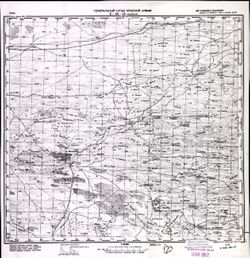
- Description:
- 1940
- Subject:
- Geographic Subject: Lineynoye, Topical Subject: Maps, and Topical Subject: Soviet Union
- Publisher:
- Генеральный штаб Красной Армии
- Language:
- Russian
- Date Created:
- 1941
- Identifier:
- VAC9619-002072
- Genre:
- Military Maps and Topographic Maps
- Geographic Location:
- Coordinates: 46, 47, 46.3333, 47.5
- Related URL:
- Catalog URL: https://iucat.iu.edu/catalog/5020129 and Download GeoTIFF: https://drive.google.com/open?id=1MibNB9hpyceu8pM7sN1fkg1uvRwQitcf
- Abstract:
- Modern area represented: Lineynoye, Astrakhan oblast, Russia
- Call Number:
- G7000 s100 .S7 sheet L-38-71
- Caption:
- Для служебного пользования
- City:
- Линейное (Lineynoye)
- Copyright Holder:
- No Copyright - United States
- Country:
- СССР (USSR)
- State/Province:
- Калмыцкая АССР (Kalmyk Autonomous Soviet Socialist Republic), РСФСР (RSFSR), and Сталинградская область (Stalingrad oblast)
- Physical Description:
- Scale: 1:100,000
- Persistent URL:
- http://purl.dlib.indiana.edu/iudl/images/VAC9619/VAC9619-002072
- Provenance:
- CIA Map Library
-
- Description:
- 1940
- Subject:
- Geographic Subject: Pavlovskaya, Topical Subject: Maps, and Topical Subject: Soviet Union
- Publisher:
- Генеральный штаб Красной Армии
- Language:
- Russian
- Date Created:
- 1941
- Identifier:
- VAC9619-002330
- Genre:
- Topographic Maps and Military Maps
- Geographic Location:
- Coordinates: 46, 39.5, 46.3333, 40
- Related URL:
- Download GeoTIFF: https://drive.google.com/file/d/1xbqEApJ5hSLMPVxfU-oodDof-dkkXh20/view?usp=sharing and Catalog URL: https://iucat.iu.edu/catalog/5020129
- Abstract:
- Modern area represented: Pavlovskaya, Russia
- Call Number:
- G7000 s100 .S7 sheet L-37-68
- Caption:
- Для служебного пользования
- City:
- Павловская (Pavlovskaya)
- Copyright Holder:
- No Copyright - United States
- Country:
- СССР (USSR)
- State/Province:
- Краснодарский край (Krasnodar kray) and РСФСР (RSFSR)
- Physical Description:
- Scale: 1:100,000
- Persistent URL:
- http://purl.dlib.indiana.edu/iudl/images/VAC9619/VAC9619-002330
- Provenance:
- DMA Topographic Center, Army Map Service Library
-
- Subject:
- Geographic Subject: Cegłów, Topical Subject: Soviet Union, and Topical Subject: Maps
- Publisher:
- Генеральный штаб Красной Армии
- Language:
- Russian
- Date Created:
- 1941
- Identifier:
- VAC9619-000336
- Genre:
- Military Maps and Topographic Maps
- Geographic Location:
- Coordinates: 52, 21.5, 52.167, 21.75
- Related URL:
- Download GeoTIFF: https://drive.google.com/open?id=1EwlXwAYp5zAgkg8DJ__OMlHFwctYLxzf and Catalog URL: http://iucat.iu.edu/catalog/5020131
- Abstract:
- Modern area represented: Cegłów, Poland
- Call Number:
- G7000 s50 .S68 sheet N-34-140-C
- Caption:
- Captured map
- City:
- Цеглув (Cegłów)
- Copyright Holder:
- No Copyright - United States
- Country:
- Область государственных интересов Германии (Region of German state interest)
- Physical Description:
- Scale: 1:50,000
- Persistent URL:
- http://purl.dlib.indiana.edu/iudl/images/VAC9619/VAC9619-000336
- Provenance:
- Army Map Service Library, OMAHA, Library of Congress Geography & Map Division
-
- Subject:
- Topical Subject: Soviet Union, Topical Subject: Maps, and Geographic Subject: Biesal
- Publisher:
- Генеральный штаб Красной Армии
- Language:
- Russian
- Date Created:
- 1941
- Identifier:
- VAC9619-003838
- Genre:
- Topographic Maps and Military Maps
- Geographic Location:
- Coordinates: 53.667, 20.125, 53.75, 20.25
- Related URL:
- Download GeoTIFF: https://drive.google.com/file/d/1vevnljNJ4E3HJI_kLkPJpL1_JMOzXOXj/view?usp=sharing and Catalog URL: https://iucat.iu.edu/catalog/14701157
- Abstract:
- Modern area represented: Biesal, Poland
- Call Number:
- G7063.K2 s25 .S6 sheet N-34-77-C-d
- City:
- Бисселен (Biessellen)
- Copyright Holder:
- No Copyright - United States
- Country:
- Германия (Восточная Пруссия) (Germany (East Prussia))
- Physical Description:
- Scale: 1:25,000
- Persistent URL:
- http://purl.dlib.indiana.edu/iudl/images/VAC9619/VAC9619-003838
- Provenance:
- Army Map Service Library, Library of Congress Geography & Map Division
-

- Description:
- 1938
- Subject:
- Geographic Subject: Novhorod-Siverskyy, Topical Subject: Maps, and Topical Subject: Soviet Union
- Publisher:
- Главное Управление Геодезии и Картографии при СНК СССР
- Language:
- Russian
- Date Created:
- 1941
- Identifier:
- VAC9619-004216
- Genre:
- Military Maps and Topographic Maps
- Geographic Location:
- Coordinates: 52, 33, 52.333, 33.5
- Related URL:
- Download GeoTIFF: https://drive.google.com/file/d/1kaJZgYyUS6Hj_BGfB5UeL-vO4ElM_lO7/view?usp=sharing and Catalog URL: https://iucat.iu.edu/catalog/5020129
- Abstract:
- Modern area represented: Novhorod-Siverskyy, Chernihiv oblast, Ukraine
- Call Number:
- G7000 s100 .S7 sheet N-36-139
- Caption:
- Для служебного пользования
- City:
- Новгород-Северский (Novhorod-Siverskyy)
- Copyright Holder:
- No Copyright - United States
- Country:
- СССР (USSR)
- State/Province:
- Черниговская область (Chernihiv oblast), Украинская ССР (Ukrainian Soviet Socialist Republic), Сумская область (Sumy oblast), РСФСР (RSFSR), and Орловская об...
- Physical Description:
- Scale: 1:100,000
- Persistent URL:
- http://purl.dlib.indiana.edu/iudl/images/VAC9619/VAC9619-004216
- Provenance:
- DMA Topographic Center, Army Map Service Library, OMAHA, Library of Congress Geography & Map Division
-
- Description:
- 1923
- Subject:
- Geographic Subject: Kazatskiye Bolsuny, Topical Subject: Maps, and Topical Subject: Soviet Union
- Publisher:
- Генеральный штаб Красной Армии
- Language:
- Russian
- Date Created:
- 1941
- Identifier:
- VAC9619-001986
- Genre:
- Military Maps and Topographic Maps
- Geographic Location:
- Coordinates: 52.6667, 31, 53, 31.5
- Related URL:
- Catalog URL: https://iucat.iu.edu/catalog/5020129 and Download GeoTIFF: https://drive.google.com/open?id=1NGZ48urLJWivl2Kfpc8aCV_5puUGsbqS
- Abstract:
- Modern area represented: Kazatskiye Bolsuny, Homyel voblasc, Belarus
- Call Number:
- G7000 s100 .S7 sheet N-36-111
- Caption:
- Для служебного пользования
- City:
- Казацкие Болсуны (Kazatskiye Bolsuny)
- Copyright Holder:
- No Copyright - United States
- Country:
- СССР (USSR)
- State/Province:
- РСФСР (RSFSR), Орловская область (Oryol oblast), Белорусская ССР (Byelorussian Soviet Socialist Republic), and Гомельская область (Homyel oblast)
- Physical Description:
- Scale: 1:100,000
- Persistent URL:
- http://purl.dlib.indiana.edu/iudl/images/VAC9619/VAC9619-001986
- Provenance:
- DMA Topographic Center, Army Map Service Library, Geographic Names Branch, Atlasblatt, OMAHA
-
- Subject:
- Topical Subject: Maps, Topical Subject: Soviet Union, and Geographic Subject: Gołymin-Ośrodek
- Publisher:
- Генеральный штаб Красной Армии
- Language:
- Russian
- Date Created:
- 1941
- Identifier:
- VAC9619-000380
- Genre:
- Topographic Maps and Military Maps
- Geographic Location:
- Coordinates: 52.6667, 20.75, 52.8333, 21
- Related URL:
- Download GeoTIFF: https://drive.google.com/open?id=1TK2aF8RMGAbdEVm4XuSX3vzj2tJntdbW and Catalog URL: http://iucat.iu.edu/catalog/5020131
- Abstract:
- Modern area represented: Gołymin-Ośrodek, Poland
- Call Number:
- G7000 s50 .S68 sheet N-114-D
- Caption:
- Captured map
- City:
- Голымин Стары
- Copyright Holder:
- No Copyright - United States
- Country:
- Область государственных интересов Германии (Region of German state interest)
- Physical Description:
- Scale: 1:50,000
- Persistent URL:
- http://purl.dlib.indiana.edu/iudl/images/VAC9619/VAC9619-000380
- Provenance:
- Army Map Service Library, OMAHA, Library of Congress Geography & Map Division
-
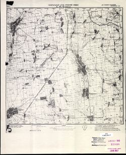
- Description:
- 1930
- Subject:
- Topical Subject: Maps, Geographic Subject: Novyy Buh, and Topical Subject: Soviet Union
- Publisher:
- Генеральный штаб Красной Армии
- Language:
- Russian
- Date Created:
- 1941
- Identifier:
- VAC9619-001863
- Genre:
- Military Maps and Topographic Maps
- Geographic Location:
- Coordinates: 47.6667, 32.5, 48, 33
- Related URL:
- Download GeoTIFF: https://drive.google.com/open?id=1T0wPHo0RpDwORrKZXGfpt1IyrZgBA6b4 and Catalog URL: https://iucat.iu.edu/catalog/5020129
- Abstract:
- Modern area represented: Novyy Buh, Mykolaiv, Ukraine
- Call Number:
- G7000 s100 .S7 sheet L-36-6
- Caption:
- Для служебного пользования
- City:
- Новый Буг (Novyy Buh)
- Copyright Holder:
- No Copyright - United States
- Country:
- СССР (USSR)
- State/Province:
- Украинская ССР (Ukrainian Soviet Socialist Republic)
- Physical Description:
- Scale: 1:100,000
- Persistent URL:
- http://purl.dlib.indiana.edu/iudl/images/VAC9619/VAC9619-001863
- Provenance:
- CIA Map Library
-

- Description:
- 1928
- Subject:
- Topical Subject: Soviet Union, Geographic Subject: Yahotyn, and Topical Subject: Maps
- Publisher:
- Генеральный штаб Красной Армии
- Language:
- Russian
- Date Created:
- 1941
- Identifier:
- VAC9619-003293
- Genre:
- Topographic Maps and Military Maps
- Geographic Location:
- Coordinates: 50, 31.5, 50.333, 32
- Related URL:
- Catalog URL: https://iucat.iu.edu/catalog/5020129 and Download GeoTIFF: https://drive.google.com/file/d/1LHmrE7SLHHk3jOpjngs2HIPoYbavjsT9/view?usp=sharing
- Abstract:
- Modern area represented: Yahotyn, Kiev oblast, Ukraine
- Call Number:
- G7000 s100 .S7 sheet M-36-64
- City:
- Яготин (Yahotyn)
- Copyright Holder:
- No Copyright - United States
- Country:
- СССР (USSR)
- State/Province:
- Черниговская область (Chernihiv oblast), Киевская область (Kyiv oblast), Украинская ССР (Ukrainian Soviet Socialist Republic), and Полтавская область (Poltav...
- Physical Description:
- Scale: 1:100,000
- Persistent URL:
- http://purl.dlib.indiana.edu/iudl/images/VAC9619/VAC9619-003293
- Provenance:
- DMA Topographic Center, Army Map Service Library, OMAHA, Library of Congress Geography & Map Division
-
- Description:
- 1936
- Subject:
- Topical Subject: Maps, Geographic Subject: Stepnaya, and Topical Subject: Soviet Union
- Publisher:
- Главное управление геодезии и картографии при СНК СССР
- Language:
- Russian
- Date Created:
- 1941
- Identifier:
- VAC9619-002337
- Genre:
- Topographic Maps and Military Maps
- Geographic Location:
- Coordinates: 45.667, 38, 46, 38.5
- Related URL:
- Catalog URL: https://iucat.iu.edu/catalog/5020129 and Download GeoTIFF: https://drive.google.com/file/d/1JbpHtvnICqALvD_ZX180f74-4Ca2Qrxr/view?usp=sharing
- Abstract:
- Modern area represented: Stepnaya, Russia
- Call Number:
- G7000 s100 .S7 sheet L-37-77
- Caption:
- Для служебного пользования
- City:
- Степная (Stepnaya)
- Copyright Holder:
- No Copyright - United States
- Country:
- СССР (USSR)
- State/Province:
- Краснодарский край (Krasnodar kray) and РСФСР (RSFSR)
- Physical Description:
- Scale: 1:100,000
- Persistent URL:
- http://purl.dlib.indiana.edu/iudl/images/VAC9619/VAC9619-002337
- Provenance:
- DMA Topographic Center, Army Map Service Library
-

- Subject:
- Topical Subject: Soviet Union, Topical Subject: Maps, and Geographic Subject: Kałuszyn
- Publisher:
- Генеральный штаб Красной Армии
- Language:
- Russian
- Date Created:
- 1941
- Identifier:
- VAC9619-000335
- Genre:
- Military Maps and Topographic Maps
- Geographic Location:
- Coordinates: 52.166667, 21.75, 52.333333, 22.0
- Related URL:
- Download GeoTIFF: https://drive.google.com/open?id=1Sb-EziIgk9d7S9DVnzeYYee0wU_oK9Q9 and Catalog URL: http://iucat.iu.edu/catalog/5020131
- Abstract:
- Modern area represented: Kałuszyn, Poland
- Call Number:
- G7000 s50 .S68 sheet N-34-140-B
- Caption:
- Captured map
- City:
- Калушин (Kałuszyn)
- Copyright Holder:
- No Copyright - United States
- Country:
- Область государственных интересов Германии (Region of German state interest)
- Physical Description:
- Scale: 1:50,000
- Persistent URL:
- http://purl.dlib.indiana.edu/iudl/images/VAC9619/VAC9619-000335
- Provenance:
- Army Map Service Library, OMAHA, Library of Congress Geography & Map Division
-

- Description:
- 1937
- Subject:
- Topical Subject: Soviet Union, Geographic Subject: Budogoshch, and Topical Subject: Maps
- Publisher:
- Главное управление геодезии и картографии при СНК СССР
- Language:
- Russian
- Date Created:
- 1941
- Identifier:
- VAC9619-002131
- Genre:
- Military Maps and Topographic Maps
- Geographic Location:
- Coordinates: 59, 32, 59.3333, 32.5
- Related URL:
- Download GeoTIFF: https://drive.google.com/open?id=1YSF-556lOfBtGACCO2UvI9SSrGDDkMYN and Catalog URL: https://iucat.iu.edu/catalog/5020129
- Abstract:
- Modern area represented: Budogoshch, Russia
- Call Number:
- G7000 s100 .S7 sheet O-36-29
- Caption:
- Для служебного пользования
- City:
- Будогощь (Budogoshch)
- Copyright Holder:
- No Copyright - United States
- Country:
- СССР (USSR)
- State/Province:
- Чудовский район (Chudovsky district), Ленинградская область (Leningrad oblast), РСФСР (RSFSR), Киришский район (Kirishsky district), and Маловишерский район ...
- Physical Description:
- Scale: 1:100,000
- Persistent URL:
- http://purl.dlib.indiana.edu/iudl/images/VAC9619/VAC9619-002131
- Provenance:
- Army Map Service Library, Library of Congress G & M Division
-
- Description:
- 1936
- Subject:
- Topical Subject: Soviet Union, Topical Subject: Maps, and Geographic Subject: Nebolchi
- Publisher:
- Главное управление геодезии и картографии при СНК СССР
- Language:
- Russian
- Date Created:
- 1941
- Identifier:
- VAC9619-002133
- Genre:
- Topographic Maps and Military Maps
- Geographic Location:
- Coordinates: 59, 33, 59.3333, 33.5
- Related URL:
- Catalog URL: https://iucat.iu.edu/catalog/5020129 and Download GeoTIFF: https://drive.google.com/open?id=1U5gzlSz2a1NCAv6mDxB8Jh7sfuf3e5mI
- Abstract:
- Modern area represented: Неболчи (Nebolchi), Novgorodskaya oblast, Russia
- Call Number:
- G7000 s100 .S7 sheet O-36-31
- Caption:
- Для служебного пользования
- City:
- Неболчи (Nebolchi)
- Copyright Holder:
- No Copyright - United States
- Country:
- СССР (USSR)
- State/Province:
- Ленинградская область (Leningrad oblast) and РСФСР (RSFSR)
- Physical Description:
- Scale: 1:100,000
- Persistent URL:
- http://purl.dlib.indiana.edu/iudl/images/VAC9619/VAC9619-002133
- Provenance:
- DMA Topographic Center, Army Map Service Library, Library of Congress G & M Division
-
- Description:
- 1931
- Subject:
- Geographic Subject: Tsatsa, Topical Subject: Maps, and Topical Subject: Soviet Union
- Publisher:
- Генеральный штаб Красной Армии
- Language:
- Russian
- Date Created:
- 1941
- Identifier:
- VAC9619-003445
- Genre:
- Military Maps and Topographic Maps
- Geographic Location:
- Coordinates: 48, 44.5, 48.333, 45
- Related URL:
- Catalog URL: https://iucat.iu.edu/catalog/5020129 and Download GeoTIFF: https://drive.google.com/file/d/1c7mgQhGy3_yLlwnSj3i7E-PDRpAxnEED/view?usp=sharing
- Abstract:
- Modern area represented: Tsatsa, Volgograd oblast, Russia
- Call Number:
- G7000 s100 .S7 sheet M-38-138
- Caption:
- Для служебного пользования
- City:
- Цаца (Tsatsa)
- Copyright Holder:
- No Copyright - United States
- Country:
- СССР (USSR)
- State/Province:
- Калмыцкая АССР (Kalmyk Autonomous Soviet Socialist Republic), РСФСР (RSFSR), and Сталинградская область (Stalingrad oblast)
- Physical Description:
- Scale: 1:100,000
- Persistent URL:
- http://purl.dlib.indiana.edu/iudl/images/VAC9619/VAC9619-003445
- Provenance:
- DMA Topographic Center, Army Map Service Library, Atlasblatt
-
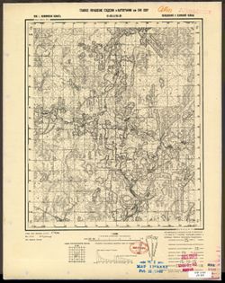
- Description:
- 1939
- Subject:
- Geographic Subject: Il’yushino, Topical Subject: Maps, and Topical Subject: Soviet Union
- Publisher:
- Главное управление геодезии и картографии при СНК СССР
- Language:
- Russian
- Date Created:
- 1941
- Identifier:
- VAC9619-003468
- Genre:
- Military Maps and Topographic Maps
- Geographic Location:
- Coordinates: 56.333, 32.5, 56.5, 32.75
- Related URL:
- Catalog URL: http://iucat.iu.edu/catalog/5020131 and Download GeoTIFF: https://drive.google.com/file/d/1gFCKXL3LEEV_HoW5baG2udOZMvB2T_-c/view?usp=sharing
- Abstract:
- Modern area represented: Ильюшино (Il’yushino), Tverskaya oblast, Russia
- Call Number:
- G7000 s50 .S68 sheet O-36-126-C
- City:
- Ильюшино (Il’yushino)
- Copyright Holder:
- No Copyright - United States
- Country:
- СССР (USSR)
- State/Province:
- Нелидовский район (Nelidovsky district), Калининская область (Kalinin oblast), and Ленинский район (Leninsky district)
- Physical Description:
- Scale: 1:50,000
- Persistent URL:
- http://purl.dlib.indiana.edu/iudl/images/VAC9619/VAC9619-003468
- Provenance:
- M. I. Map Library, Library of Congress Geography & Map Division
-
- Description:
- 1925
- Subject:
- Topical Subject: Soviet Union, Geographic Subject: Tsimlyansk, and Topical Subject: Maps
- Publisher:
- Генеральный штаб Красной Армии
- Language:
- Russian
- Date Created:
- 1941
- Identifier:
- VAC9619-002446
- Genre:
- Military Maps and Topographic Maps
- Geographic Location:
- Coordinates: 47.667, 42, 48, 42.5
- Related URL:
- Catalog URL: https://iucat.iu.edu/catalog/5020129 and Download GeoTIFF: https://drive.google.com/file/d/1Fq1CUNGjISP3jwHQkOyng30sRx-ec3HY/view?usp=sharing
- Abstract:
- Modern area represented: Tsimlyansk, Russia
- Call Number:
- G7000 s100 .S7 sheet L-38-1
- Caption:
- Для служебного пользования
- City:
- Цымлянская (Tsimlyanskaya)
- Copyright Holder:
- No Copyright - United States
- Country:
- СССР (USSR)
- State/Province:
- РСФСР (RSFSR) and Ростовская область (Rostov oblast)
- Physical Description:
- Scale: 1:100,000
- Persistent URL:
- http://purl.dlib.indiana.edu/iudl/images/VAC9619/VAC9619-002446
- Provenance:
- Army Map Service Library, Library of Congress G & M Division
-
- Subject:
- Geographic Subject: Ukhorskoye, Topical Subject: Soviet Union, and Topical Subject: Maps
- Publisher:
- Генеральный штаб Красной Армии
- Language:
- Russian
- Date Created:
- 1941
- Identifier:
- VAC9619-003137
- Genre:
- Military Maps and Topographic Maps
- Geographic Location:
- Coordinates: 54, 40, 54.333, 40.5
- Related URL:
- Catalog URL: https://iucat.iu.edu/catalog/5020129 and Download GeoTIFF: https://drive.google.com/file/d/1TfeiMIeVfiVZZyMg4MuD_-OlqnRGrCmk/view?usp=sharing
- Abstract:
- Modern area represented: Ухорское (Ukhorskoye), Ryazanskaya oblast, Russia
- Call Number:
- G7000 s100 .S7 sheet N-37-69
- City:
- Ухорская (Ukhorskaya)
- Copyright Holder:
- No Copyright - United States
- Country:
- СССР (USSR)
- State/Province:
- РСФСР (RSFSR) and Рязанская область (Ryazan oblast)
- Physical Description:
- Scale: 1:100,000
- Persistent URL:
- http://purl.dlib.indiana.edu/iudl/images/VAC9619/VAC9619-003137
- Provenance:
- DMA Topographic Center, Army Map Service Library, Gruppe Archive Auslandskartenarchiv
-
- Description:
- 1930
- Subject:
- Topical Subject: Soviet Union, Geographic Subject: Navlya, and Topical Subject: Maps
- Publisher:
- Генеральный штаб Красной Армии
- Language:
- Russian
- Date Created:
- 1941
- Identifier:
- VAC9619-004196
- Genre:
- Military Maps and Topographic Maps
- Geographic Location:
- Coordinates: 52.667, 34, 53, 34.5
- Related URL:
- Download GeoTIFF: https://drive.google.com/file/d/12YHzNYr3tdcPK9AY8xD-otjolRp85ej1/view?usp=sharing and Catalog URL: https://iucat.iu.edu/catalog/5020129
- Abstract:
- Modern area represented: Navlya, Bryansk oblast, Russia
- Call Number:
- G7000 s100 .S7 sheet N-36-117
- City:
- Навля (Navlya)
- Copyright Holder:
- No Copyright - United States
- Country:
- СССР (USSR)
- State/Province:
- Орловская область (Oryol oblast) and РСФСР (RSFSR)
- Physical Description:
- Scale: 1:100,000
- Persistent URL:
- http://purl.dlib.indiana.edu/iudl/images/VAC9619/VAC9619-004196
- Provenance:
- DMA Topographic Center, Army Map Service Library, OMAHA
-
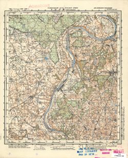
- Subject:
- Geographic Subject: Darsūniškis, Topical Subject: Soviet Union, and Topical Subject: Maps
- Publisher:
- Генеральный штаб Красной Армии
- Language:
- Russian
- Date Created:
- 1941
- Identifier:
- VAC9619-000522
- Genre:
- Military Maps and Topographic Maps
- Geographic Location:
- Coordinates: 54.6667, 24, 54.8333, 24.25
- Related URL:
- Catalog URL: http://iucat.iu.edu/catalog/5020131 and Download GeoTIFF: https://drive.google.com/open?id=1J1xb-H1oQhiom6Du9L0ftYYMyrI-1Img
- Abstract:
- Modern area represented: Darsūniškis, Lithuania
- Call Number:
- G7000 s50 .S68 sheet N-35-37-C
- Caption:
- Для служебного пользования
- City:
- Дорсунишки (Dorsunishki)
- Copyright Holder:
- No Copyright - United States
- Country:
- СССР (USSR)
- State/Province:
- Литовская ССР (Lithuanian Soviet Socialist Republic)
- Physical Description:
- Scale: 1:50,000
- Persistent URL:
- http://purl.dlib.indiana.edu/iudl/images/VAC9619/VAC9619-000522
- Provenance:
- M. I. Map Library
-
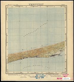
- Subject:
- Topical Subject: Maps, Topical Subject: Soviet Union, and Geographic Subject: Przebrno
- Publisher:
- Генеральный штаб Красной Армии
- Language:
- Russian
- Date Created:
- 1941
- Identifier:
- VAC9619-003726
- Genre:
- Military Maps and Topographic Maps
- Geographic Location:
- Coordinates: 54.333, 19.25, 54.417, 19.375
- Related URL:
- Download GeoTIFF: https://drive.google.com/file/d/1CLV6-QjLkr3uyiNtmTa1PIy0iQBKYM80/view?usp=sharing and Catalog URL: https://iucat.iu.edu/catalog/14701157
- Abstract:
- Modern area represented: Przebrno, part of the town of Krynica Morska, Poland
- Call Number:
- G7063.K2 s25 .S6 sheet N-34-51-D-c
- City:
- Преббернау (Pröbbernau)
- Copyright Holder:
- No Copyright - United States
- Country:
- Германия (Germany)
- Physical Description:
- Scale: 1:25,000
- Persistent URL:
- http://purl.dlib.indiana.edu/iudl/images/VAC9619/VAC9619-003726
- Provenance:
- M. I. Map Library
-
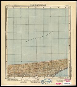
- Subject:
- Geographic Subject: Kąty Rybackie, Topical Subject: Soviet Union, and Topical Subject: Maps
- Publisher:
- Генеральный штаб Красной Армии
- Language:
- Russian
- Date Created:
- 1941
- Identifier:
- VAC9619-003725
- Genre:
- Topographic Maps and Military Maps
- Geographic Location:
- Coordinates: 54.333, 19.125, 54.417, 19.25
- Related URL:
- Download GeoTIFF: https://drive.google.com/file/d/1nthUYSIAKdjoclMMA8ArWuM2ha_r6Ch6/view?usp=sharing and Catalog URL: https://iucat.iu.edu/catalog/14701157
- Abstract:
- Modern area represented: Kąty Rybackie, Poland
- Call Number:
- G7063.K2 s25 .S6 sheet N-34-51-C-d
- City:
- Боденвинкель (Bodenwinkel)
- Copyright Holder:
- No Copyright - United States
- Country:
- Германия (Germany)
- Physical Description:
- Scale: 1:25,000
- Persistent URL:
- http://purl.dlib.indiana.edu/iudl/images/VAC9619/VAC9619-003725
- Provenance:
- M. I. Map Library
-
- Description:
- 1939
- Subject:
- Geographic Subject: Sukhinichi, Topical Subject: Maps, and Topical Subject: Soviet Union
- Publisher:
- Генеральный штаб Красной Армии
- Language:
- Russian
- Date Created:
- 1941
- Identifier:
- VAC9619-001899
- Genre:
- Topographic Maps and Military Maps
- Geographic Location:
- Coordinates: 54, 35, 54.3333, 35.5
- Related URL:
- Catalog URL: https://iucat.iu.edu/catalog/5020129 and Download GeoTIFF: https://drive.google.com/open?id=1XGjkZ3m9w5I6YreHuiesrh-XU2TxBbbT
- Abstract:
- Modern area represented: Сухиничи (Sukhinichi), Kaluzhskaya oblast, Russia
- Call Number:
- G7000 s100 .S7 sheet N-36-71
- City:
- Сухиничи (Sukhinichi)
- Copyright Holder:
- No Copyright - United States
- Country:
- СССР (USSR)
- State/Province:
- РСФСР (RSFSR) and Смоленская область (Smolensk oblast)
- Physical Description:
- Scale: 1:100,000
- Persistent URL:
- http://purl.dlib.indiana.edu/iudl/images/VAC9619/VAC9619-001899
- Provenance:
- DMA Topographic Center, Army Map Service Library, OMAHA, Library of Congress Geography & Map Division, Auswärtiges Amt. Geographischer Dienst
-

- Subject:
- Topical Subject: Soviet Union, Topical Subject: Maps, and Geographic Subject: Zapyškis
- Publisher:
- Генеральный штаб Красной Армии
- Language:
- Russian
- Date Created:
- 1941
- Identifier:
- VAC9619-003722
- Genre:
- Topographic Maps and Military Maps
- Geographic Location:
- Coordinates: 54.913, 23.625, 55, 23.75
- Related URL:
- Catalog URL: https://iucat.iu.edu/catalog/14701157 and Download GeoTIFF: https://drive.google.com/file/d/1PAMqLanXnzAq1f9dj7s_PUqP_lpBr_F1/view?usp=sharing
- Abstract:
- Modern area represented: Zapyškis, Lithuania
- Call Number:
- G7063.K2 s25 .S6 sheet N-34-48-A-b
- Caption:
- Секретно
- City:
- Сапежишки (Sapezhishki)
- Copyright Holder:
- No Copyright - United States
- Country:
- СССР (USSR)
- State/Province:
- Литовская ССР (Lithuanian Soviet Socialist Republic)
- Physical Description:
- Scale: 1:25,000
- Persistent URL:
- http://purl.dlib.indiana.edu/iudl/images/VAC9619/VAC9619-003722
- Provenance:
- M. I. Map Library, CIA Map Library
-
- Description:
- 1940
- Subject:
- Topical Subject: Soviet Union, Geographic Subject: Bolkhov, and Topical Subject: Maps
- Publisher:
- Генеральный штаб Красной Армии
- Language:
- Russian
- Date Created:
- 1941
- Identifier:
- VAC9619-001972
- Genre:
- Topographic Maps and Military Maps
- Geographic Location:
- Coordinates: 53.3333, 35.5, 53.6667, 36
- Related URL:
- Download GeoTIFF: https://drive.google.com/open?id=18ijvg4xDFn0cRWVFTrYHEi0Qc9iOp0SF and Catalog URL: https://iucat.iu.edu/catalog/5020129
- Abstract:
- Modern area represented: Bolkhov, Russia
- Call Number:
- G7000 s100 .S7 sheet N-36-96
- Caption:
- Captured map
- City:
- Болхов (Bolkhov)
- Copyright Holder:
- No Copyright - United States
- Country:
- СССР (USSR)
- State/Province:
- Орловская область (Oryol oblast) and РСФСР (RSFSR)
- Physical Description:
- Scale: 1:100,000
- Persistent URL:
- http://purl.dlib.indiana.edu/iudl/images/VAC9619/VAC9619-001972
- Provenance:
- DMA Topographic Center, Army Map Service Library, OMAHA, Library of Congress Geography & Map Division
-
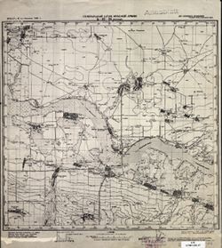
- Description:
- 1932
- Subject:
- Topical Subject: Soviet Union, Topical Subject: Maps, and Geographic Subject: Veselyy
- Publisher:
- Генеральный штаб Красной Армии
- Language:
- Russian
- Date Created:
- 1941
- Identifier:
- VAC9619-002288
- Genre:
- Topographic Maps and Military Maps
- Geographic Location:
- Coordinates: 47, 40.5, 47.3333, 41
- Related URL:
- Download GeoTIFF: https://drive.google.com/file/d/1x_6moHatJsnMhQhHzqjSPuO0h_az_FsS/view?usp=sharing and Catalog URL: https://iucat.iu.edu/catalog/5020129
- Abstract:
- Modern area represented: Veselyy, Russia
- Call Number:
- G7000 s100 .S7 sheet L-37-34
- Caption:
- Для служебного пользования
- City:
- Веселый (Veselyy)
- Copyright Holder:
- No Copyright - United States
- Country:
- СССР (USSR)
- State/Province:
- Ростовская область (Rostov oblast) and РСФСР (RSFSR)
- Physical Description:
- Scale: 1:100,000
- Persistent URL:
- http://purl.dlib.indiana.edu/iudl/images/VAC9619/VAC9619-002288
- Provenance:
- CIA Map Library
-
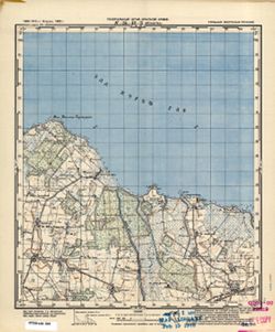
- Subject:
- Topical Subject: Soviet Union, Geographic Subject: Slavyanskoye, and Topical Subject: Maps
- Publisher:
- Генеральный штаб Красной Армии
- Language:
- Russian
- Date Created:
- 1941
- Identifier:
- VAC9619-000296
- Genre:
- Military Maps and Topographic Maps
- Geographic Location:
- Coordinates: 54.8333, 20.75, 55, 21
- Related URL:
- Download GeoTIFF: https://drive.google.com/open?id=1JpCxQGs-ku7_aKK9QJ-Yi8d6ojOEGJ1Z and Catalog URL: http://iucat.iu.edu/catalog/5020131
- Abstract:
- Modern area represented: Slavyanskoye, Kaliningrad oblast, Russia
- Call Number:
- G7000 s50 .S68 sheet N-34-42-B
- City:
- Прониттен (Pronitten)
- Copyright Holder:
- No Copyright - United States
- Country:
- Восточная Пруссия (East Prussia) and Германия (Germany)
- Physical Description:
- Scale: 1:50,000
- Persistent URL:
- http://purl.dlib.indiana.edu/iudl/images/VAC9619/VAC9619-000296
- Provenance:
- M. I. Map Library, G000-30, GS, RA
-
- Description:
- 1937
- Subject:
- Topical Subject: Maps, Topical Subject: Soviet Union, and Geographic Subject: Peresyp
- Publisher:
- Генеральный штаб Красной Армии
- Language:
- Russian
- Date Created:
- 1941
- Identifier:
- VAC9619-002346
- Genre:
- Military Maps and Topographic Maps
- Geographic Location:
- Coordinates: 45.333, 37, 45.667, 37.5
- Related URL:
- Catalog URL: https://iucat.iu.edu/catalog/5020129 and Download GeoTIFF: https://drive.google.com/file/d/1et56BJZlxN599zRb53buMBYVstda6Ec_/view?usp=sharing
- Abstract:
- Modern area represented: Peresyp, Russia
- Call Number:
- G7000 s100 .S7 sheet L-37-87
- Caption:
- Для служебного пользования
- City:
- Пересыпь (Peresyp)
- Copyright Holder:
- No Copyright - United States
- Country:
- СССР (USSR)
- State/Province:
- Краснодарский край (Krasnodar kray) and РСФСР (RSFSR)
- Physical Description:
- Scale: 1:100,000
- Persistent URL:
- http://purl.dlib.indiana.edu/iudl/images/VAC9619/VAC9619-002346
- Provenance:
- DMA Topographic Center, Army Map Service Library, Library of Congress Geography & Map Division
-
- Description:
- 1939
- Subject:
- Geographic Subject: Boldino, Topical Subject: Soviet Union, and Topical Subject: Maps
- Publisher:
- Генеральный штаб Красной Армии
- Language:
- Russian
- Date Created:
- 1941
- Identifier:
- VAC9619-004183
- Genre:
- Military Maps and Topographic Maps
- Geographic Location:
- Coordinates: 54.667, 33.5, 55, 34
- Related URL:
- Download GeoTIFF: https://drive.google.com/file/d/1ZdOE8E-RdZYHTBsQ0CUY54GuqYB5ylfV/view?usp=sharing and Catalog URL: https://iucat.iu.edu/catalog/5020129
- Abstract:
- Modern area represented: Boldino, Smolensk oblast, Russia
- Call Number:
- G7000 s100 .S7 sheet N-36-44
- City:
- Болдино (Boldino)
- Copyright Holder:
- No Copyright - United States
- Country:
- СССР (USSR)
- State/Province:
- Смоленская область (Smolensk oblast) and РСФСР (RSFSR)
- Physical Description:
- Scale: 1:100,000
- Persistent URL:
- http://purl.dlib.indiana.edu/iudl/images/VAC9619/VAC9619-004183
- Provenance:
- DMA Topographic Center, Library of Congress G & M Division, OMAHA, Army Map Service Library
-
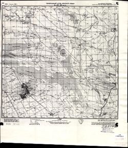
- Description:
- 1928
- Subject:
- Geographic Subject: Manychskoye, Topical Subject: Soviet Union, and Topical Subject: Maps
- Publisher:
- Генеральный штаб Красной Армии
- Language:
- Russian
- Date Created:
- 1941
- Identifier:
- VAC9619-002063
- Genre:
- Topographic Maps and Military Maps
- Geographic Location:
- Coordinates: 46, 43, 46.3333, 43.5
- Related URL:
- Download GeoTIFF: https://drive.google.com/open?id=1n-R1bSl6LZW_J3pMeBtQTM79GYtOIJNr and Catalog URL: https://iucat.iu.edu/catalog/5020129
- Abstract:
- Modern area represented: Manychskoye, Stavropol kray, Russia
- Call Number:
- G7000 s100 .S7 sheet L-38-63
- Caption:
- Для служебного пользования
- City:
- Киста (Kista)
- Copyright Holder:
- No Copyright - United States
- Country:
- СССР (USSR)
- State/Province:
- Орджоникидзевский край (Ordzhonikidze kray), Калмыцкая АССР (Kalmyk Autonomous Soviet Socialist Republic), РСФСР (RSFSR), and Ростовская область (Rostov oblast)
- Physical Description:
- Scale: 1:100,000
- Persistent URL:
- http://purl.dlib.indiana.edu/iudl/images/VAC9619/VAC9619-002063
- Provenance:
- CIA Map Library
-
- Description:
- 1938
- Subject:
- Topical Subject: Maps, Topical Subject: Soviet Union, and Geographic Subject: Rydelovo
- Publisher:
- Главное Управление Геодезии и Картографии при СНК СССР
- Language:
- Russian
- Date Created:
- 1941
- Identifier:
- VAC9619-001205
- Genre:
- Military Maps and Topographic Maps
- Geographic Location:
- Coordinates: 55.8333, 33.25, 56, 33.5
- Related URL:
- Download GeoTIFF: https://drive.google.com/open?id=1QB4vYv8ua3rj35GjIUhueXlyBl0DdP-y and Catalog URL: http://iucat.iu.edu/catalog/5020131
- Abstract:
- Modern area represented: Rydelovo, Tver oblast, Russia
- Call Number:
- GM G7000 S50 .S68 N-36-7-Б
- Copyright Holder:
- No Copyright - United States
- Country:
- СССР (USSR)
- State/Province:
- РСФСР (RSFSR), Калининская область (Kalinin oblast), and Смоленская область (Smolensk oblast)
- Physical Description:
- Scale: 1:50,000
- Persistent URL:
- http://purl.dlib.indiana.edu/iudl/images/VAC9619/VAC9619-001205
- Provenance:
- DMA Topographic Center, Army Map Service Library, Library of Congress Geography & Map Division
-
- Description:
- 1916
- Subject:
- Geographic Subject: Bohuslav, Topical Subject: Maps, and Topical Subject: Soviet Union
- Publisher:
- Генеральный штаб Красной Армии
- Language:
- Russian
- Date Created:
- 1941
- Identifier:
- VAC9619-003300
- Genre:
- Military Maps and Topographic Maps
- Geographic Location:
- Coordinates: 51.333, 24.5, 51.667, 25
- Related URL:
- Download GeoTIFF: https://drive.google.com/file/d/1odAb6QmUNYwAarOu4M6GwN34sjA31HHV/view?usp=sharing and Catalog URL: https://iucat.iu.edu/catalog/5020129
- Abstract:
- Modern area represented: Bohuslav, Kiev oblast, Ukraine
- Call Number:
- G7000 s100 .S7 sheet M-36-86
- Caption:
- Для служебного пользования
- City:
- Богуслав (Bohuslav)
- Copyright Holder:
- No Copyright - United States
- Country:
- СССР (USSR)
- State/Province:
- Украинская ССР (Ukrainian Soviet Socialist Republic) and Киевская область (Kyiv oblast)
- Physical Description:
- Scale: 1:100,000
- Persistent URL:
- http://purl.dlib.indiana.edu/iudl/images/VAC9619/VAC9619-003300
- Provenance:
- DMA Topographic Center, Army Map Service Library, OMAHA, Library of Congress Geography & Map Division
