
Search Constraints
You searched for:
Date Created
1970
Remove constraint Date Created: 1970
Holding Location
B-WELLS
Remove constraint Holding Location: B-WELLS
Search Results
-
- Subject:
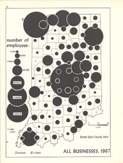
- Topical Subject: Labor supply, Topical Subject: Business enterprises--Employees, and Geographic Subject: Indiana
- Creator:
- Hollingsworth, John M. and Kingsbury, Robert C.
- Publisher:
- Indiana University. Department of Geography
- Date Created:
- 1970
- Identifier:
- VAC3073-M-00226
- Genre:
- Thematic maps
- Geographic Location:
- Coordinates: W0880700 W0844500 N0414500 N0374600
- Related URL:
- Catalog URL: https://iucat.iu.edu/catalog/15948581
- Abstract:
- Graduated symbol map. Shows number of employees by county. Detached from: An atlas of Indiana / by Robert C. Kingsbury , with contributions from John M. H...
- Call Number:
- G4091.G8 1967 .K56
- Caption:
- Imprint: Bloomington, Indiana : Department of Geography, Indiana University, [1970]
- Physical Description:
- Dimensions: 26 x 18 cm, on sheet 28 x 21 cm and Scale: Approximately 1:1,950,000
- Alternate Identifier:
- Alternate ID: 317383IP and Title Control Number: a15948581
- Persistent URL:
- https://purl.dlib.indiana.edu/iudl/images/VAC3073/VAC3073-M-00226
- Provenance:
- An atlas of Indiana / by Robert C. Kingsbury [1970].
-
![Area map [map] : Nashville and park entrance](https://iiif.uits.iu.edu/iiif/2/cf95kd75c%2Ffiles%2F50f0a63b-dc6d-4bda-a229-140148a2252e/full/250,/0/default.jpg)
- Subject:
- Geographic Subject: Brown County State Park (Ind.) and Geographic Subject: Nashville (Ind.)
- Publisher:
- [publisher not identified]
- Date Created:
- 1970
- Identifier:
- VAC3073-M-00225
- Genre:
- Maps
- Geographic Location:
- Coordinates: W0861450 W0861220 N0391229 N0391130
- Related URL:
- Catalog URL: https://iucat.iu.edu/catalog/4896982
- Abstract:
- Blue line print. Shows corporate limits of Nashville Indiana, roads, some buildings, Salt Creek, the north entrance to Brown County State Park and distances...
- Call Number:
- G4094 .N25 1970 .A74
- Caption:
- Imprint: [place of publication not identified] : [publisher not identified], [1970?]
- Physical Description:
- Dimensions: 42 x 66 cm and Scale: Scale not given.
- Alternate Identifier:
- Title Control Number: a4896982
- Persistent URL:
- https://purl.dlib.indiana.edu/iudl/images/VAC3073/VAC3073-M-00225
-
- Subject:
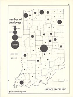
- Topical Subject: Service industries workers, Geographic Subject: Indiana, and Topical Subject: Labor supply
- Creator:
- Hollingsworth, John M. and Kingsbury, Robert C.
- Publisher:
- Indiana University. Department of Geography
- Date Created:
- 1970
- Identifier:
- VAC3073-M-00224
- Genre:
- Thematic maps
- Geographic Location:
- Coordinates: W0880700 W0844500 N0414500 N0374600
- Related URL:
- Catalog URL: https://iucat.iu.edu/catalog/15950444
- Abstract:
- Graduated symbol map. Shows number of employees by county. Detached from: An atlas of Indiana / by Robert C. Kingsbury , with contributions from John M. H...
- Call Number:
- G4091.G8 1967 .K57
- Caption:
- Imprint: Bloomington, Indiana : Department of Geography, Indiana University, [1970]
- Physical Description:
- Dimensions: 26 x 18 cm, on sheet 28 x 21 cm and Scale: Approximately 1:1,950,000
- Alternate Identifier:
- Alternate ID: 317383IP and Title Control Number: a15950444
- Persistent URL:
- https://purl.dlib.indiana.edu/iudl/images/VAC3073/VAC3073-M-00224
- Provenance:
- An atlas of Indiana / by Robert C. Kingsbury [1970].
-
- Subject:
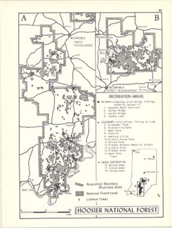
- Topical Subject: Public lands, Geographic Subject: Hoosier National Forest (Ind.), Topical Subject: Forest reserves, and Topical Subject: Outdoor recreation
- Creator:
- Hollingsworth, John M. and Kingsbury, Robert C.
- Publisher:
- Indiana University. Department of Geography
- Date Created:
- 1970
- Identifier:
- VAC3073-M-00211
- Genre:
- Tourist maps
- Geographic Location:
- Coordinates: W0865130 W0861800 N0385800 N0375000
- Related URL:
- Catalog URL: https://iucat.iu.edu/catalog/15938174
- Abstract:
- Shows primary and secondary recreation areas, recreation areas under construction, lookout towers, acquisition boundary (purchase unit), and Hoosier National...
- Call Number:
- G1400 .K53 1970
- Caption:
- Imprint: Bloomington, Indiana : Department of Geography, Indiana University, [1970]
- Physical Description:
- Scale: Approximately 1:550,000 and Dimensions: 26 x 18 cm, on sheet 28 x 21 cm
- Alternate Identifier:
- Alternate ID: 317383IP and Title Control Number: a15938174
- Persistent URL:
- https://purl.dlib.indiana.edu/iudl/images/VAC3073/VAC3073-M-00211
- Provenance:
- An atlas of Indiana / by Robert C. Kingsbury [1970].
-
- Subject:
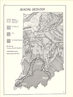
- Topical Subject: Glacial landforms, Geographic Subject: Indiana, Topical Subject: Geology, and Topical Subject: Drift
- Creator:
- Hollingsworth, John M. and Kingsbury, Robert C.
- Publisher:
- Indiana University. Department of Geography
- Date Created:
- 1970
- Identifier:
- VAC3073-M-00201
- Genre:
- Geological maps
- Geographic Location:
- Coordinates: W0880700 W0844500 N0414500 N0374600
- Related URL:
- Catalog URL: https://iucat.iu.edu/catalog/15939117
- Abstract:
- Shows outwash (lake and river sediments), end moraines, drift and un-glaciated bedrock. Also shows Illinoian glacial boundary and Kansas glacial boundary. ...
- Call Number:
- G4091.C5 1970 .K56
- Caption:
- Imprint: Bloomington, Indiana : Department of Geography, Indiana University, [1970]
- Physical Description:
- Scale: Approximately 1:2,000,000 and Dimensions: 26 x 18 cm, on sheet 28 x 21 cm
- Alternate Identifier:
- Alternate ID: 317383IP and Title Control Number: a15939117
- Persistent URL:
- https://purl.dlib.indiana.edu/iudl/images/VAC3073/VAC3073-M-00201
- Provenance:
- An atlas of Indiana / by Robert C. Kingsbury [1970].
-

- Subject:
- Topical Subject: Labor supply, Topical Subject: Manufacturing industries--Employees, and Geographic Subject: Indiana
- Creator:
- Kingsbury, Robert C. and Hollingsworth, John M.
- Publisher:
- Indiana University. Department of Geography
- Date Created:
- 1970
- Identifier:
- VAC3073-M-00186
- Genre:
- Thematic maps
- Geographic Location:
- Coordinates: W0880700 W0844500 N0414500 N0374600
- Related URL:
- Catalog URL: https://iucat.iu.edu/catalog/15950528
- Abstract:
- Graduated symbol map showing number of employees by county. Detached from: An atlas of Indiana / by Robert C. Kingsbury , with contributions from John M. ...
- Call Number:
- G4091.G8 1967 .K58
- Caption:
- Imprint: Bloomington, Indiana : Department of Geography, Indiana University, [1970]
- Physical Description:
- Scale: Approximately 1:1,950,000 and Dimensions: 26 x 18 cm
- Alternate Identifier:
- Alternate ID: 317383IP and Title Control Number: a15950528
- Persistent URL:
- https://purl.dlib.indiana.edu/iudl/images/VAC3073/VAC3073-M-00186
- Provenance:
- An atlas of Indiana / by Robert C. Kingsbury [1970].
-
- Subject:
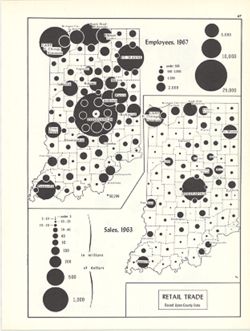
- Topical Subject: Retail trade--Employees, Geographic Subject: Indiana, and Topical Subject: Labor supply
- Creator:
- Hollingsworth, John M. and Kingsbury, Robert C.
- Publisher:
- Indiana University. Department of Geography
- Date Created:
- 1970
- Identifier:
- VAC3073-M-00179
- Genre:
- Thematic maps
- Geographic Location:
- Coordinates: W0880700 W0844500 N0414500 N0374600
- Related URL:
- Catalog URL: https://iucat.iu.edu/catalog/15987122
- Abstract:
- 2 maps on 1 sheet, Retail trade employees, 1967, and Retail trade sales, 1963. Graduated symbol map. Detached from: An atlas of Indiana / by Robert C. Kin...
- Call Number:
- G4091.G8 1963 .K57
- Caption:
- Imprint: Bloomington, Indiana : Department of Geography, Indiana University, [1970]
- Physical Description:
- Dimensions: on sheet 28 x 21 cm and Scale: Approximately 1:2,700,000
- Alternate Identifier:
- Alternate ID: 317383IP and Title Control Number: a15987122
- Persistent URL:
- https://purl.dlib.indiana.edu/iudl/images/VAC3073/VAC3073-M-00179
- Provenance:
- An atlas of Indiana / by Robert C. Kingsbury [1970].
-
- Subject:
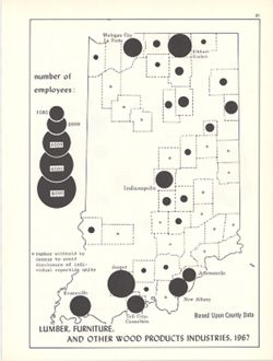
- Geographic Subject: Indiana, Topical Subject: Furniture industry and trade, Topical Subject: Labor supply, Topical Subject: Forest products industry, and Top...
- Creator:
- Kingsbury, Robert C. and Hollingsworth, John M.
- Publisher:
- Indiana University, Bloomington. Department of Geography
- Date Created:
- 1970
- Identifier:
- VAC3073-M-00174
- Genre:
- Thematic maps and Statistical maps
- Geographic Location:
- Coordinates: W0880700 W0844500 N0414500 N0374600
- Related URL:
- Catalog URL: https://iucat.iu.edu/catalog/18452119
- Abstract:
- Choropleth map with graduated circles showing the number of employees in each county employed by wood product industries in 1967. "Based upon county dat...
- Call Number:
- G4091.G8 1967 .K55
- Caption:
- Imprint: [Bloomington, Indiana] : [Department of Geography, Indiana University], [1970]
- Physical Description:
- Scale: Scale not given. and Dimensions: 26 x 18 cm
- Alternate Identifier:
- Alternate ID: 317383IP and Title Control Number: a18452119
- Persistent URL:
- https://purl.dlib.indiana.edu/iudl/images/VAC3073/VAC3073-M-00174
- Provenance:
- An atlas of Indiana / by Robert C. Kingsbury [1970].
-
- Subject:
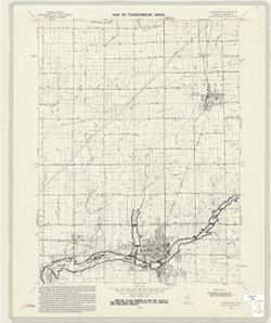
- Topical Subject: Flood forecasting, Geographic Subject: Madison County (Ind.), Topical Subject: Floods, Geographic Subject: Alexandria Region (Ind.), and Top...
- Creator:
- Geological Survey (U.S.)
- Publisher:
- Geological Survey (U.S.)
- Date Created:
- 1970
- Identifier:
- VAC3073-M-00162
- Genre:
- 7.5 minute topographic maps, Topographic maps, and Quadrangle maps
- Geographic Location:
- Coordinates: W0854500 W0853730 N0402230 N0401500
- Related URL:
- Catalog URL: https://iucat.iu.edu/catalog/18416051
- Abstract:
- Filing title: Alexandria, Ind. Relief shown by contours and spot heights. Contour interval 10 feet. Includes quadrangle location map. Flood prone areas and o...
- Call Number:
- G4091.C32 s24 .G4 Alexandria 1970
- Caption:
- Imprint: Washington, D.C. : Interior--Geological Survey, [1970]
- Physical Description:
- Scale: 1:24,000 and Dimensions: 59 x 45 or smaller
- Alternate Identifier:
- Alternate ID: CAW5372BB and Title Control Number: a18416051
- Persistent URL:
- https://purl.dlib.indiana.edu/iudl/images/VAC3073/VAC3073-M-00162
- Provenance:
- United States Department of the Interior, Geological Survey. Map of flood-prone areas : [Indiana]. Washington, D.C. : The Survey, 1969-.
-
- Subject:
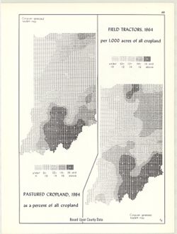
- Topical Subject: Farm tractors, Topical Subject: SYMAP (Computer program language), Geographic Subject: Indiana, and Topical Subject: Pastures
- Creator:
- Indiana University. Research Computing Center and Kingsbury, Robert C.
- Publisher:
- Indiana University. Department of Geography
- Date Created:
- 1970
- Identifier:
- VAC3073-M-00148
- Genre:
- Thematic maps
- Geographic Location:
- Coordinates: W0880700 W0844500 N0414500 N0374600
- Related URL:
- Catalog URL: https://iucat.iu.edu/catalog/15995411
- Abstract:
- 2 maps on 1 sheet, Pastured cropland, 1964, as a percent of all cropland and Field tractors, 1964, per 1,000 acres of all cropland. Computer generated isople...
- Call Number:
- G4091.J5 1964 .K55
- Caption:
- Imprint: Bloomington, Indiana : Department of Geography, Indiana University, [1970]
- Physical Description:
- Scale: Approximately 1:3,000,000 and Dimensions: each 26 x 10 cm, on sheet 28 x 21 cm
- Alternate Identifier:
- Title Control Number: a15995411 and Alternate ID: 317383IP
- Persistent URL:
- https://purl.dlib.indiana.edu/iudl/images/VAC3073/VAC3073-M-00148
- Provenance:
- An atlas of Indiana / by Robert C. Kingsbury [1970].
