
Search Constraints
You searched for:
Publisher
Geological Survey (U.S.)
Remove constraint Publisher: Geological Survey (U.S.)
« Previous |
1 - 10 of 159
|
Next »
Search Results
-
![Indiana Bloomington quadrangle [1946 reprint with 21 indexed cave locations]](https://iiif.uits.iu.edu/iiif/2/dz011t645%2Ffiles%2Fbb3033b6-3144-4af2-a6c7-a5710771ff06/full/250,/0/default.jpg)
- Subject:
- Geographic Subject: Owen County (Ind.), Geographic Subject: Monroe County (Ind.), Topical Subject: Caves, and Geographic Subject: Greene County (Ind.)
- Creator:
- Griffin, W. H. (William H.), Marshall, R. B. (Robert Bradford), 1867-1949, Sadler, C. L., and Herron, W. H. (William Harrison), 1865-
- Publisher:
- Geological Survey (U.S.)
- Date Created:
- 1946
- Identifier:
- VAC3073-M-01218
- Genre:
- Topographic maps, Quadrangle maps, and 15 minute topographic maps
- Geographic Location:
- Coordinates: W0864500 W0863000 N0391500 N0390000
- Related URL:
- Catalog URL: https://iucat.iu.edu/catalog/18406221
- Abstract:
- R. B. Marshall, chief geographer , W. H. Herron, Geographer in charge , topography by W. H. Griffin and C. L. Sandler , Control by J. R. Ellis and C. H. Semp...
- Call Number:
- G4090 s62 .G4 Bloomington 1910 R1946
- Caption:
- Imprint: [Washington, D.C.] : United States, Department of the Interior, Geological Survey, [1946]
- Physical Description:
- Scale: 1:62,500 and Dimensions: 45 x 42 cm or smaller
- Alternate Identifier:
- Title Control Number: a18406221
- Persistent URL:
- https://purl.dlib.indiana.edu/iudl/images/VAC3073/VAC3073-M-01218
- Provenance:
- Part of Geological Survey (U.S.). Indiana 1:62,500.
-
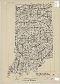
- Subject:
- Geographic Subject: Indiana
- Creator:
- Geological Survey (U.S.)
- Publisher:
- Geological Survey (U.S.)
- Date Created:
- 1950
- Identifier:
- VAC3073-M-00311
- Genre:
- Thematic maps
- Geographic Location:
- Coordinates: W0880700 W0844700 N0414500 N0374600
- Related URL:
- Catalog URL: https://iucat.iu.edu/catalog/2256717
- Abstract:
- "Printed 1950"--Margin.
- Call Number:
- G4091 .A1 1950 .G4
- Caption:
- Imprint: Washington, D.C.: The Survey, 1950.
- Physical Description:
- Dimensions: 91 x 58 cm, on sheet 108 x 69 cm and Scale: 1:500,000
- Alternate Identifier:
- Title Control Number: BGY3152BB
- Persistent URL:
- https://purl.dlib.indiana.edu/iudl/images/VAC3073/VAC3073-M-00311
-
![Indiana Bloomington quadrangle [1948 reprint]](https://iiif.uits.iu.edu/iiif/2/2j62t788s%2Ffiles%2F57d817cb-ee47-4ed5-9f38-24d8a93dcb0b/full/250,/0/default.jpg)
- Subject:
- Geographic Subject: Owen County (Ind.), Geographic Subject: Greene County (Ind.), and Geographic Subject: Monroe County (Ind.)
- Creator:
- Marshall, R. B. (Robert Bradford), 1867-1949, Herron, W. H. (William Harrison), 1865-, Griffin, W. H. (William H.), and Sadler, C. L.
- Publisher:
- Geological Survey (U.S.)
- Date Created:
- 1948
- Identifier:
- VAC3073-M-01219
- Genre:
- Topographic maps, 15 minute topographic maps, and Quadrangle maps
- Geographic Location:
- Coordinates: W0880000 W0844500 N0414500 N0375200
- Related URL:
- Catalog URL: https://iucat.iu.edu/catalog/18406221
- Abstract:
- R. B. Marshall, chief geographer , W. H. Herron, Geographer in charge , topography by W. H. Griffin and C. L. Sandler , Control by J. R. Ellis and C. H. Semp...
- Call Number:
- G4090 s62 .G4 Bloomington 1910 R1948
- Caption:
- Imprint: [Washington, D.C.] : United States, Department of the Interior, Geological Survey, [1948]
- Physical Description:
- Dimensions: 45 x 42 cm or smaller and Scale: 1:62,500
- Alternate Identifier:
- Title Control Number: a18406221
- Persistent URL:
- https://purl.dlib.indiana.edu/iudl/images/VAC3073/VAC3073-M-01219
- Provenance:
- Part of Geological Survey (U.S.). Indiana 1:62,500.
-
![Indiana Bloomington quadrangle [1946 reprint]](https://iiif.uits.iu.edu/iiif/2/qj72qc04t%2Ffiles%2F069e9c1e-7c2e-4931-8df9-5ba99812cae2/full/250,/0/default.jpg)
- Subject:
- Geographic Subject: Monroe County (Ind.), Geographic Subject: Owen County (Ind.), and Geographic Subject: Greene County (Ind.)
- Creator:
- Griffin, W. H. (William H.), Marshall, R. B. (Robert Bradford), 1867-1949, Herron, W. H. (William Harrison), 1865-, and Sadler, C. L.
- Publisher:
- Geological Survey (U.S.)
- Date Created:
- 1946
- Identifier:
- VAC3073-M-01295
- Genre:
- 15 minute topographic maps, Topographic maps, and Quadrangle maps
- Geographic Location:
- Coordinates: W0864500 W0863000 N0391500 N0390000
- Related URL:
- Catalog URL: https://iucat.iu.edu/catalog/18406221
- Abstract:
- R. B. Marshall, chief geographer , W. H. Herron, Geographer in charge , topography by W. H. Griffin and C. L. Sandler , Control by J. R. Ellis and C. H. Semp...
- Call Number:
- G4090 s62 .G4 Bloomington 1910 R1946
- Caption:
- Imprint: [Washington, D.C.] : United States, Department of the Interior, Geological Survey, [1946]
- Physical Description:
- Scale: 1:62,500 and Dimensions: 45 x 42 cm or smaller
- Alternate Identifier:
- Title Control Number: a18406221
- Persistent URL:
- https://purl.dlib.indiana.edu/iudl/images/VAC3073/VAC3073-M-01295
- Provenance:
- Part of Geological Survey (U.S.). Indiana 1:62,500.
-
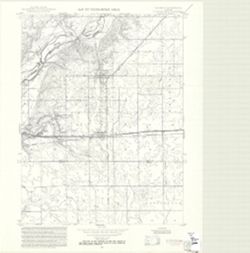
- Subject:
- Geographic Subject: Henry County (Ind.), Geographic Subject: Rush County (Ind.), Topical Subject: Floods, Topical Subject: Floodplains, and Topical Subject: ...
- Creator:
- Geological Survey (U.S.)
- Publisher:
- Geological Survey (U.S.)
- Date Created:
- 1970
- Identifier:
- VAC3073-M-00304
- Genre:
- Quadrangle maps, Topographic maps, and 7.5 minute topographic maps
- Geographic Location:
- Coordinates: W0853000 W0852230 N0395230 N0394500
- Related URL:
- Catalog URL: https://iucat.iu.edu/catalog/18416259
- Abstract:
- Filing title: Dunreith, Ind. Relief shown by contours and spot heights. Contour interval 10 feet. Includes quadrangle location map. Flood prone areas and occ...
- Call Number:
- G4091.C32 s24 .G4 Dunreith, Ind. 1970
- Caption:
- Imprint: [Washington, D.C.] : [Interior--Geological Survey], [1970]
- Physical Description:
- Scale: 1:24,000 and Dimensions: 59 x 45 or smaller
- Alternate Identifier:
- Title Control Number: a18416259 and Alternate ID: CAW5372BB
- Persistent URL:
- https://purl.dlib.indiana.edu/iudl/images/VAC3073/VAC3073-M-00304
- Provenance:
- United States Department of the Interior, Geological Survey. Map of flood-prone areas : [Indiana]. Washington, D.C. : The Survey, 1969-.
-
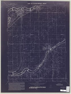
- Subject:
- Topical Subject: Flood forecasting, Topical Subject: Floodplains, Geographic Subject: Delaware County (Ind.), Topical Subject: Floods, Geographic Subject: Ma...
- Creator:
- United States. Federal Insurance Administration and Geological Survey (U.S.)
- Publisher:
- Geological Survey (U.S.)
- Date Created:
- 1970
- Identifier:
- VAC3073-M-00235
- Genre:
- Topographic maps, Quadrangle maps, and 7.5 minute topographic maps
- Geographic Location:
- Coordinates: W0855230 W0854500 N0403730 N0403000
- Related URL:
- Catalog URL: https://iucat.iu.edu/catalog/18416331
- Abstract:
- Filing title: Middletown, Ind. Relief shown by contours and spot heights. Contour interval 10 feet. Includes quadrangle location map. Shows portion of Henry,...
- Call Number:
- G4091.C32 s24 .G4 Middletown, Ind. 1970
- Caption:
- Imprint: Washington, D.C. : Interior--Geological Survey, [1970]
- Physical Description:
- Dimensions: 59 x 45 or smaller and Scale: 1:24,000
- Alternate Identifier:
- Title Control Number: a18416331 and Alternate ID: CAW5372BB
- Persistent URL:
- https://purl.dlib.indiana.edu/iudl/images/VAC3073/VAC3073-M-00235
- Provenance:
- Map of Flood-Prone Areas: Middletown Quadrangle, Indiana.
-
![Illinois-Indiana-Kentucky, New Haven quadrangle [1966 reprint with vegetation]](https://iiif.uits.iu.edu/iiif/2/k0699966z%2Ffiles%2F2ec905c7-1ce1-46fe-974b-b888b96b34a5/full/250,/0/default.jpg)
- Subject:
- Geographic Subject: Posey County (Ind.), Geographic Subject: White County (Ill.), Geographic Subject: Union County (Ky.), Geographic Subject: Gallatin County...
- Creator:
- Lloyd, W. J. (Topographer), Smith, L. Scott, Illinois State Geological Survey, Wilson, Herbert M. (Herbert Michael), 1860-1920, Ellis, J. R. (Topographer), C...
- Publisher:
- Geological Survey (U.S.)
- Date Created:
- 1966
- Identifier:
- VAC3073-M-01357
- Genre:
- Quadrangle maps, Topographic maps, and 15 minute topographic maps
- Geographic Location:
- Coordinates: W0881500 W0880000 N0380000 N0374500
- Related URL:
- Catalog URL: https://iucat.iu.edu/catalog/18413861
- Abstract:
- United States, Department of the Interior, Geological Survey , State of Illinois, Department of Registration and Education, Geological Survey Division , Stat...
- Call Number:
- G4090 s62 .G4 New Haven 1905 rep 1966 V
- Caption:
- Imprint: Washington, D.C. : Interior--Geological Survey, 1956
- Physical Description:
- Dimensions: 45 x 42 cm or smaller and Scale: 1:62,500
- Alternate Identifier:
- Title Control Number: a18413861
- Persistent URL:
- https://purl.dlib.indiana.edu/iudl/images/VAC3073/VAC3073-M-01357
- Provenance:
- Part of Geological Survey (U.S.). Indiana 1:62,500.
-
![Indiana Oolitic quadrangle : 15-minute series [1960 reprint with vegetation]](https://iiif.uits.iu.edu/iiif/2/r207vs27b%2Ffiles%2F9aee9db3-93e4-41e1-9ed6-b3a8d5c9e95c/full/250,/0/default.jpg)
- Subject:
- Geographic Subject: Greene County (Ind.), Topical Subject: Vegetation mapping, Geographic Subject: Martin County (Ind.), Geographic Subject: Monroe County (I...
- Creator:
- McKinley, W. K. (William Klett), 1891-1964 and Geological Survey (U.S.)
- Publisher:
- Geological Survey (U.S.)
- Date Created:
- 1960
- Identifier:
- VAC3073-M-01372
- Genre:
- 15 minute topographic maps, Quadrangle maps, and Topographic maps
- Geographic Location:
- Coordinates: W0864500 W0863000 N0390000 N0384500
- Related URL:
- Catalog URL: https://iucat.iu.edu/catalog/18413831
- Abstract:
- Topography by W.K. McKinley [and seven others]. Polyconic projection. Relief shown by contours and spot heights. Contour interval 20 feet. Shows portion of L...
- Call Number:
- G4090 s62 .G4 Oolitic 1960 V
- Caption:
- Imprint: Washington, D.C. : Interior--Geological Survey, 1960
- Physical Description:
- Dimensions: 45 x 42 cm or smaller and Scale: 1:62,500
- Alternate Identifier:
- Title Control Number: a18413831
- Persistent URL:
- https://purl.dlib.indiana.edu/iudl/images/VAC3073/VAC3073-M-01372
- Provenance:
- Part of Geological Survey (U.S.). Indiana 1:62,500.
-
![Illinois-Indiana-Kentucky, New Haven quadrangle [1939 reprint without vegetation]](https://iiif.uits.iu.edu/iiif/2/qj72qc053%2Ffiles%2Fbde64e1d-6659-4d18-a8c8-db54ce923770/full/250,/0/default.jpg)
- Subject:
- Geographic Subject: Union County (Ky.), Geographic Subject: Gallatin County (Ill.), Geographic Subject: White County (Ill.), and Geographic Subject: Posey Co...
- Creator:
- Geological Survey (U.S.)
- Publisher:
- Geological Survey (U.S.)
- Date Created:
- 1939
- Identifier:
- VAC3073-M-01359
- Genre:
- Quadrangle maps, Topographic maps, and 15 minute topographic maps
- Geographic Location:
- Coordinates: W0881500 W0880000 N0380000 N0374500
- Related URL:
- Catalog URL: https://iucat.iu.edu/catalog/18413859
- Abstract:
- United States, Department of the Interior, Geological Survey , State of Illinois, Department of Registration and Education, Geological Survey Division , Stat...
- Call Number:
- G4090 s62 .G4 New Haven 1906 rep 1939
- Caption:
- Imprint: [Washington, D.C.] : U.S. Geological Survey, [1939]
- Physical Description:
- Dimensions: 45 x 42 cm or smaller and Scale: 1:62,500
- Alternate Identifier:
- Title Control Number: a18413859
- Persistent URL:
- https://purl.dlib.indiana.edu/iudl/images/VAC3073/VAC3073-M-01359
- Provenance:
- Part of Geological Survey (U.S.). Indiana 1:62,500.
-
![Kentucky-Indiana Cannelton quadrangle [1941 reprint]](https://iiif.uits.iu.edu/iiif/2/8336j442q%2Ffiles%2F47a90ccc-f6f3-4558-aeaf-5356b28b815d/full/250,/0/default.jpg)
- Subject:
- Geographic Subject: Breckinridge County (Ky.) and Geographic Subject: Hancock County (Ind.)
- Creator:
- United States. Army. Corps of Engineers, Tull, L. E. (Lawrence Emerson), 1894-1987, Higginson, W. S. (William Smith Muir), 1894-1984, and Runyan, R. H.
- Publisher:
- Geological Survey (U.S.)
- Date Created:
- 1941
- Identifier:
- VAC3073-M-01326
- Genre:
- Quadrangle maps, Topographic maps, and 15 minute topographic maps
- Geographic Location:
- Coordinates: W0864500 W0863000 N0380000 N0374500
- Related URL:
- Catalog URL: https://iucat.iu.edu/catalog/18415999
- Abstract:
- Topography by R.H. Runyan, W.S. Higginson, and L.E. Tull , Ohio River by Corps of Engineers, U.S. Army. Polyconic projection. Relief shown by contours and sp...
- Call Number:
- G4090 s62 .G4 Cannelton 1934 rep1941
- Caption:
- Imprint: Washington, D.C. : Dept. of the Interior, U.S. Geological Survey, 1941
- Physical Description:
- Dimensions: 45 x 42 cm or smaller and Scale: 1:62,500
- Alternate Identifier:
- Title Control Number: a18415999
- Persistent URL:
- https://purl.dlib.indiana.edu/iudl/images/VAC3073/VAC3073-M-01326
- Provenance:
- Part of Geological Survey (U.S.). Indiana 1:62,500.
