Geographic Subject: Perry County (Ind.), Geographic Subject: Spencer County (Ind.), Topical Subject: Coal, and Geographic Subject: Warrick County (Ind.)
Creator:
Ashley, Geo. H. (George Hall), 1866-1951, Kindle, E. M. (Edward Martin), 1869-1940, and Price, J. A.
Publisher:
Indiana. Department of Geology and Natural Resources
Date Created:
1898
Identifier:
VAC3073-M-01185
Genre:
Geological maps
Geographic Location:
Coordinates: W0872823 W0862942 N0381446 N0374639
Related URL:
Catalog URL: https://iucat.iu.edu/catalog/9160352
Abstract:
By George H. Ashley, assistant geologist, Department of Geology and Natural Resources of Indiana, W.S. Blatchley, state geologist , geology by G.H. Ashley, J...
Call Number:
G4093.W4H9 1898 .A8
Caption:
Imprint: Indianapolis : Burford, [1899] and Imprint: [Indianapolis, Ind.] : Dept. of Geology and Natural Resources of Indiana, [1899]
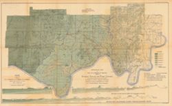
Shows Mansfield sandstone areas and quarries. Plate VIII. Detached from: Area of Mansfield sandstone / mapped by T.C. Hopkins [and] E.M. Kindle. In Indian...
Call Number:
G4091.H5 1895 .H6
Caption:
Imprint: [Indianapolis] : [Indiana Department of Geology and Natural Resources], [1896] and Imprint: Indianapolis : Wm. B. Burford, [1896]
Physical Description:
Scale: Approximately 1:1,788,600 and Dimensions: 30 x 23 cm
Alternate Identifier:
Alternate ID: 390726IP and Title Control Number: a18416374
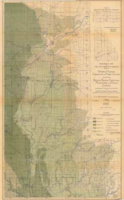
Topical Subject: IGS Annual Reports, Topical Subject: Mines and mineral resources, Topical Subject: Church buildings, Topical Subject: Geology, and Geographi...
Creator:
Kindle, E. M. (Edward Martin), 1869-1940
Publisher:
Indiana. Department of Geology and Natural Resources
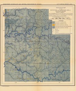
Shows the locations of coal, sandstone, and limestone areas as well as the locations of quarries, coal mines, and churches. Detached from: The carbonifero...
Call Number:
G4093.O6H1 1895 .K56
Caption:
Imprint: Indianapolis, Ind. : Wm. B. Burford, Lith., 1896
Physical Description:
Scale: Approximately 1:126,720. 2 miles = 1 inch and Dimensions: 33 x 27 cm
Alternate Identifier:
Title Control Number: a18175514 and Alternate ID: 390726IP
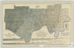
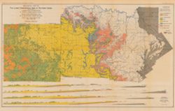
Relief shown by spot heights. Includes map showing coal locations and features, and quarries as well as vertical cross-sections through center of Township 3 ...
Call Number:
G4093.P4H9 1898 .A84
Caption:
Imprint: Indianapolis : Burford, [1899]
Physical Description:
Dimensions: 48 x 78 cm and Scale: Approximately 1:126,720. 1 inch = 2 miles. Vertical scale approximately 1:4,800. 1 inch = 400 feet
Alternate Identifier:
Title Control Number: a18175917 and Alternate ID: 390726IP
Relief shown by profile. Shows two geological cross-sections. "Based upon Congressional land surveys, field work of Ind. Geol. Survey, county atlases.&q...
Call Number:
G4093.W4H9 1898 .A8x
Caption:
Imprint: Indianapolis : Burford, [1899] and Imprint: [Indianapolis, Ind.] : Dept. of Geology and Natural Resources of Indiana, [1899]
Physical Description:
Scale: Approximately 1:126,720. 2 miles = 1 inch. Vertical scale approximately 1:4,800. 400 feet = 1 inch and Dimensions: 49 x 77 cm
Alternate Identifier:
Alternate ID: 390726IP and Title Control Number: a16848969
Includes 4 East-West cross-sections through the center of townships 1, 2 and 3 North and 1 South. Vertical scale 1:9,600. Detached from: The geology of th...
Call Number:
G4091.C5 1902 .A82
Caption:
Imprint: [Indianapolis] : Department of Geology and Natural Resources of Indiana, [1903] and Imprint: Indianapolis, Ind. : Wm. B. Burford, [1903]
Physical Description:
Dimensions: 46 x 74 cm, on sheet 50 x 78 cm and Scale: Approximately 1:126,720. 2 miles = 1 in. Vertical scale approximately 1:9,600. 800 feet = 1 in.
Alternate Identifier:
Title Control Number: a16076838 and Alternate ID: 390726IP
From the 27th Annual report of the Department of Geology and Natural Resources of Indiana, 1902. Includes three East-West cross-sections: through New Amsterd...
Call Number:
G4091.C5 1902 .A81
Caption:
Imprint: [Indianapolis] : [Wm. B. Burford], [1903] and Imprint: [Indianapolis] : [Indiana Department of Geology and Natural Resources], [1902]
Physical Description:
Scale: Approximately 1:126,720. 2 miles = 1 in. Vertical scale approximately 1:9,600. 800 feet = 1 in. and Dimensions: 51 x 76 cm, on sheet 56 x 80 cm
Alternate Identifier:
Title Control Number: a16076820 and Alternate ID: 390726IP
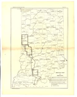
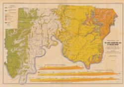
Geographic Subject: Putnam County (Ind.), Geographic Subject: Benton County (Ind.), Geographic Subject: Fountain County (Ind.), Geographic Subject: Newton Co...
Creator:
Ashley, Geo. H. (George Hall), 1866-1951, Siebenthal, C. E. (Claude Ellsworth), 1869-1930, and Kindle, E. M. (Edward Martin), 1869-1940
Publisher:
Indiana. Department of Geology and Natural Resources
Relief shown by spot heights. Includes map showing coal locations and features, railroads, and quarries as well as two inset maps for parts of Newton and Ben...
Call Number:
G4093.W3H9 1898 .A84
Caption:
Imprint: Indianapolis, Ind. : Wm. B. Burford, [1899]
Physical Description:
Dimensions: 79 x 48 cm and Scale: Approximately 1:126,720. 2 miles = 1 inch
Alternate Identifier:
Alternate ID: 390726IP and Title Control Number: a18265361