
Search Constraints
You searched for:
Date Created
1939
Remove constraint Date Created: 1939
Holding Location
B-WELLS
Remove constraint Holding Location: B-WELLS
« Previous |
1 - 10 of 95
|
Next »
Search Results
-
- Description:
- 1939
- Subject:
- Geographic Subject: Polyana and Topical Subject: Soviet Union
- Publisher:
- Главное управление геодезии и картографии при СНК СССР
- Language:
- Russian
- Date Created:
- 1939
- Identifier:
- VAC9619-000007
- Genre:
- Topographic Maps and Military Maps
- Geographic Location:
- Coordinates: 59.6667, 31.25, 59.8333, 31.5
- Related URL:
- Catalog URL: http://iucat.iu.edu/catalog/5020131 and Download GeoTIFF: https://drive.google.com/open?id=1QhVDxDghHww023dj3SHGuFISgFPnOpeM
- Abstract:
- Modern area represented: Polyana, Russia
- Call Number:
- G7000 s50 .S68 sheet O-36-3-D
- City:
- Поляна (Polyana)
- Copyright Holder:
- No Copyright - United States
- Country:
- СССР (USSR)
- State/Province:
- Ленинградская область (Leningrad oblast), Мгинский район (Mginsky district), and РСФСР (RSFSR)
- Physical Description:
- Scale: 1:50,000
- Persistent URL:
- http://purl.dlib.indiana.edu/iudl/images/VAC9619/VAC9619-000007
- Provenance:
- Army Map Service Library, OMAHA, Library of Congress Geography & Map Division
-
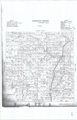
- Subject:
- Topical Subject: Real property, Geographic Subject: Washington (Monroe County, Ind. : Township), and Topical Subject: Landowners
- Creator:
- Stevens, Katherine (Mapmaker)
- Publisher:
- Stevens, Katherine (Mapmaker)
- Date Created:
- 1939
- Identifier:
- VAC3073-M-01525
- Genre:
- Cadastral maps
- Geographic Location:
- Coordinates: W0863534 W0862752 N0392013 N0391503
- Related URL:
- Catalog URL: https://iucat.iu.edu/catalog/18408369
- Abstract:
- Made by Katherine Stevens. Title in lower right corner: Plat #2, Washington Twp. Shows roads, creeks, churches, cemeteries, schools, and owner names with acr...
- Call Number:
- G4093.M7G46 1939 .S74 Washington
- Caption:
- Imprint: Bloomington, Indiana : Katherine Stevens, [1939]
- Physical Description:
- Scale: Approximately 1:18,000. 1,500 feet = 1 inch and Dimensions: on sheet 92 x 59 cm
- Alternate Identifier:
- Title Control Number: a18408369
- Persistent URL:
- https://purl.dlib.indiana.edu/iudl/images/VAC3073/VAC3073-M-01525
- Provenance:
- Katherine Stevens. Township maps of Monroe County, Indiana, [1939]
-
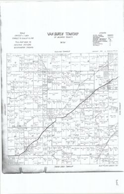
- Subject:
- Topical Subject: Real property, Topical Subject: Landowners, and Geographic Subject: Van Buren (Monroe County, Ind. : Township)
- Creator:
- Stevens, Katherine (Mapmaker)
- Publisher:
- Stevens, Katherine (Mapmaker)
- Date Created:
- 1939
- Identifier:
- VAC3073-M-01526
- Genre:
- Cadastral maps
- Geographic Location:
- Coordinates: W0864055 W0863423 N0390953 N0390446
- Related URL:
- Catalog URL: https://iucat.iu.edu/catalog/18408348
- Abstract:
- Made by Katherine Stevens. Title in lower right corner: Plat #7, Van Buren Twp. Shows roads, creeks, churches, cemeteries, schools, and owner names with acre...
- Call Number:
- G4093.M7G46 1939 .S74 Van Buren
- Caption:
- Imprint: Bloomington, Indiana : Katherine Stevens, [1939]
- Physical Description:
- Dimensions: on sheet 92 x 59 cm and Scale: Approximately 1:18,000. 1,500 feet = 1 inch
- Alternate Identifier:
- Title Control Number: a18408348
- Persistent URL:
- https://purl.dlib.indiana.edu/iudl/images/VAC3073/VAC3073-M-01526
- Provenance:
- Katherine Stevens. Township maps of Monroe County, Indiana, [1939]
-
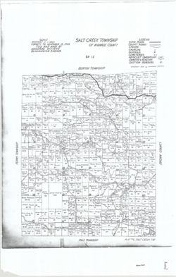
- Subject:
- Topical Subject: Real property, Topical Subject: Landowners, and Geographic Subject: Salt Creek (Monroe County, Ind. : Township)
- Creator:
- Stevens, Katherine (Mapmaker)
- Publisher:
- Stevens, Katherine (Mapmaker)
- Date Created:
- 1939
- Identifier:
- VAC3073-M-01519
- Genre:
- Cadastral maps
- Geographic Location:
- Coordinates: W0862738 W0862209 N0390953 N0390440
- Related URL:
- Catalog URL: https://iucat.iu.edu/catalog/18408344
- Abstract:
- Made by Katherine Stevens. Title in lower right corner: Plat #9, Salt Creek Twp. Shows roads, creeks, churches, cemeteries, schools, and owner names with acr...
- Call Number:
- G4093.M7G46 1939 .S74 Salt Creek
- Caption:
- Imprint: Bloomington, Indiana : Katherine Stevens, [1939]
- Physical Description:
- Scale: 1:18,000. 1,500 feet = 1 inch and Dimensions: on sheet 92 x 59 cm
- Alternate Identifier:
- Title Control Number: a18408344
- Persistent URL:
- https://purl.dlib.indiana.edu/iudl/images/VAC3073/VAC3073-M-01519
- Provenance:
- Katherine Stevens. Township maps of Monroe County, Indiana, [1939]
-
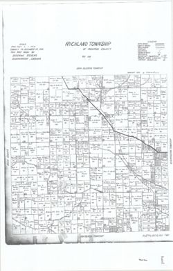
- Subject:
- Geographic Subject: Richland (Monroe County, Ind. : Township), Topical Subject: Real property, and Topical Subject: Landowners
- Creator:
- Stevens, Katherine (Mapmaker)
- Publisher:
- Stevens, Katherine (Mapmaker)
- Date Created:
- 1939
- Identifier:
- VAC3073-M-01518
- Genre:
- Cadastral maps
- Geographic Location:
- Coordinates: W0864102 W0863423 N0391509 N0390951
- Related URL:
- Catalog URL: https://iucat.iu.edu/catalog/18409340
- Abstract:
- Made by Katherine Stevens. Title in lower right corner: Plat #4, Richland Twp. Shows roads, creeks, railroads, churches, cemeteries, schools, and owner names...
- Call Number:
- G4093.M7G46 1939 .S74 Richland
- Caption:
- Imprint: Bloomington, Indiana : Katherine Stevens, [1939]
- Physical Description:
- Dimensions: on sheet 92 x 59 cm and Scale: Approximately 1:18,000. 1,500 feet = 1 inch
- Alternate Identifier:
- Title Control Number: a18409340
- Persistent URL:
- https://purl.dlib.indiana.edu/iudl/images/VAC3073/VAC3073-M-01518
- Provenance:
- Katherine Stevens. Township maps of Monroe County, Indiana, [1939]
-
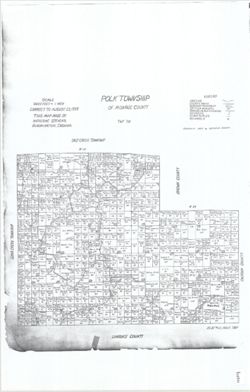
- Subject:
- Geographic Subject: Polk (Monroe County, Ind. : Township), Topical Subject: Landowners, and Topical Subject: Real property
- Creator:
- Stevens, Katherine (Mapmaker)
- Publisher:
- Stevens, Katherine (Mapmaker)
- Date Created:
- 1939
- Identifier:
- VAC3073-M-01516
- Genre:
- Cadastral maps
- Geographic Location:
- Coordinates: W0862741 W0861901 N0390447 N0385936
- Related URL:
- Catalog URL: https://iucat.iu.edu/catalog/18408242
- Abstract:
- Made by Katherine Stevens. Title in lower right corner: Plat #12, Polk Twp. Shows roads, creeks, churches, cemeteries, schools, and owner names with acreage....
- Call Number:
- G4093.M7G46 1939 .S74 Polk
- Caption:
- Imprint: Bloomington, Indiana : Katherine Stevens, [1939]
- Physical Description:
- Scale: 1:18,000. 1,500 feet = 1 inch and Dimensions: on sheet 92 x 59 cm
- Alternate Identifier:
- Title Control Number: a18408242
- Persistent URL:
- https://purl.dlib.indiana.edu/iudl/images/VAC3073/VAC3073-M-01516
- Provenance:
- Katherine Stevens. Township maps of Monroe County, Indiana, [1939]
-
- Subject:
- Geographic Subject: Pike County (Ind.), Topical Subject: Real property, and Topical Subject: Landowners
- Creator:
- Skinner, John, of Winslow, Indiana
- Publisher:
- Skinner, John, of Winslow, Indiana
- Date Created:
- 1939
- Identifier:
- VAC3073-M-01276
- Genre:
- Cadastral maps
- Geographic Location:
- Coordinates: W0872751 W0870420 N0383309 N0381355
- Related URL:
- Catalog URL: https://iucat.iu.edu/catalog/18455588
- Abstract:
- Variant title: Pike County, Indiana. Winslow, Indiana. Shows private and corporate landownership, roads, railroads, and shy ditches. "John Skinner, Wins...
- Caption:
- Imprint: [Winslow, Ind.?] : [John Skinner], [1939]
- Physical Description:
- Scale: Approximately 1:31,680. 2" = 1 mile and Dimensions: 110 x 108 cm, on sheet 118 x 113 cm
- Alternate Identifier:
- Title Control Number: a18455588
- Persistent URL:
- https://purl.dlib.indiana.edu/iudl/images/VAC3073/VAC3073-M-01276
-
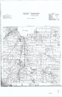
- Subject:
- Geographic Subject: Perry (Monroe County, Ind. : Township), Topical Subject: Real property, and Topical Subject: Landowners
- Creator:
- Stevens, Katherine (Mapmaker)
- Publisher:
- Stevens, Katherine (Mapmaker)
- Date Created:
- 1939
- Identifier:
- VAC3073-M-01521
- Genre:
- Cadastral maps
- Geographic Location:
- Coordinates: W0863423 W0862741 N0390952 N0390531
- Related URL:
- Catalog URL: https://iucat.iu.edu/catalog/18409336
- Abstract:
- Made by Katherine Stevens. Title in lower right corner: Plat #8, Perry Twp. Shows roads, creeks, railroads, churches, cemeteries, schools, and owner names wi...
- Call Number:
- G4093.M7G46 1939 .S74 Perry
- Caption:
- Imprint: Bloomington, Indiana : Katherine Stevens, [1939]
- Physical Description:
- Scale: Approximately 1:18,000. 1,500 feet = 1 inch and Dimensions: on sheet 92 x 59 cm
- Alternate Identifier:
- Title Control Number: a18409336
- Persistent URL:
- https://purl.dlib.indiana.edu/iudl/images/VAC3073/VAC3073-M-01521
- Provenance:
- Katherine Stevens. Township maps of Monroe County, Indiana, [1939]
-
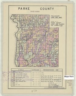
- Subject:
- Geographic Subject: Parke County (Ind.) and Topical Subject: Land use
- Creator:
- Parke County (Ind.). Land Use Planning Committee
- Publisher:
- United States. Bureau of Agricultural Economics
- Date Created:
- 1939
- Identifier:
- VAC3073-M-00689
- Genre:
- Thematic maps
- Geographic Location:
- Coordinates: W0872602 W0870034 N0395712 N0393617
- Related URL:
- Catalog URL: https://iucat.iu.edu/catalog/5126505
- Abstract:
- "Color reproduction by Bureau of Agricultural Economics, U.S.D.A." "3-30-39." Includes chart showing type of land use, acreage, and recom...
- Call Number:
- G4093.P2G4 1939 .P37
- Caption:
- Imprint: [Washington, D.C.?] : U.S. Bureau of Agricultural Economics, [1939]
- Physical Description:
- Dimensions: 17 x 16 cm, on sheet 28 x 22 cm and Scale: Scale not given.
- Alternate Identifier:
- Title Control Number: a5126505
- Persistent URL:
- https://purl.dlib.indiana.edu/iudl/images/VAC3073/VAC3073-M-00689
-
- Subject:
- Topical Subject: Maps, Geographic Subject: Priozersk, and Topical Subject: Soviet Union
- Publisher:
- Генеральный штаб Красной Армии
- Language:
- Russian
- Date Created:
- 1939
- Identifier:
- VAC9619-002552
- Genre:
- Topographic Maps and Military Maps
- Geographic Location:
- Coordinates: 61, 30, 61.333, 30.5
- Related URL:
- Download GeoTIFF: https://drive.google.com/file/d/1g54YRaxR5u9Q8rWtAobT02KApYuNbo5P/view?usp=sharing and Catalog URL: https://iucat.iu.edu/catalog/5020129
- Abstract:
- Modern area represented: Приозерск (Priozersk), Ленинградская область (Leningradskaya oblast), Russia
- Call Number:
- G7000 s100 .S7 sheet P-36-97
- Caption:
- Для служебного пользования
- City:
- Кякисальми (Kyakisalmi)
- Copyright Holder:
- No Copyright - United States
- Country:
- СССР (USSR)
- State/Province:
- Карело-Финская ССР (Karelo-Finnish Soviet Socialist Republic)
- Physical Description:
- Scale: 1:100,000
- Persistent URL:
- http://purl.dlib.indiana.edu/iudl/images/VAC9619/VAC9619-002552
- Provenance:
- DMA Topographic Center, Army Map Service Library, OMAHA
