
Search Constraints
You searched for:
Creator
Geological Survey (U.S.)
Remove constraint Creator: Geological Survey (U.S.)
« Previous |
1 - 10 of 160
|
Next »
Search Results
-
- Subject:
- Geographic Subject: Indiana
- Creator:
- Geological Survey (U.S.)
- Publisher:
- The Survey
- Date Created:
- 1992
- Identifier:
- VAC3073-M-01035
- Genre:
- Index maps and Topographic maps
- Geographic Location:
- Coordinates: W0880000 W0850000 N0410000 N0380000
- Related URL:
- Catalog URL: https://iucat.iu.edu/catalog/3789391
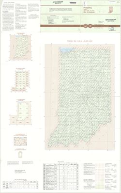
- Abstract:
- "This index is designed to inform map users of the various map series, special maps, and map byproducts produced and distributed by the U.S. Geological ...
- Call Number:
- G4091.A2 1992 .G4
- Caption:
- Imprint: Reston, Va. : The Survey and Imprint: Denver, Colo. : Map Distribution, [1992]
- Physical Description:
- Dimensions: 130 x 81 cm and Scale: 1:24,000
- Alternate Identifier:
- Title Control Number: BMX1897NW
- Persistent URL:
- https://purl.dlib.indiana.edu/iudl/images/VAC3073/VAC3073-M-01035
-
- Subject:
- Topical Subject: Counties, Geographic Subject: Indiana, and Topical Subject: Administrative and political divisions
- Creator:
- Geological Survey (U.S.)
- Publisher:
- Geological Survey (U.S.)
- Date Created:
- 1988
- Identifier:
- VAC3073-M-00025
- Genre:
- Maps
- Geographic Location:
- Coordinates: W0890000 W0840000 N0420000 N0373000
- Related URL:
- Catalog URL: https://iucat.iu.edu/catalog/18428209
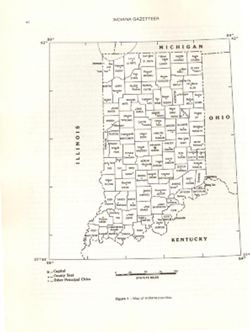
- Abstract:
- At head of caption title: "Figure 1." Appears as Figure 1 in Indiana Gazetteer produced by the U.S.G.S. Professional Paper 1200-I. "The Nation...
- Call Number:
- QE75 .A4 No. 1200-IN
- Caption:
- Imprint: [Reston, Va.] : [The Survey], [1988]
- Physical Description:
- Dimensions: 29 cm or smaller and Scale: Approximately 1:3,200,000
- Alternate Identifier:
- Title Control Number: a18428209 and Alternate ID: 358171IP
- Persistent URL:
- https://purl.dlib.indiana.edu/iudl/images/VAC3073/VAC3073-M-00025
- Provenance:
- The National gazetteer of the United States of America--Indiana, 1988 / U.S. Geological Survey.
-
- Subject:
- Geographic Subject: Jackson County (Ind.), Geographic Subject: Bartholomew County (Ind.), and Geographic Subject: Jennings County (Ind.)
- Creator:
- Geological Survey (U.S.)
- Publisher:
- United States. Defense Mapping Agency. Topographic Center
- Date Created:
- 1983
- Identifier:
- VAC3073-M-01425
- Genre:
- Quadrangle maps, 15 minute topographic maps, and Topographic maps
- Geographic Location:
- Coordinates: W0860000 W0854500 N0391500 N0390000
- Related URL:
- Catalog URL: https://iucat.iu.edu/catalog/18376110
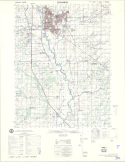
- Abstract:
- Prepared by the U.S. Geological Survey for publication by the Defense Mapping Agency Hydrographic/Topographic Center. Variant title: Indiana 1:50,000. Standa...
- Call Number:
- G4090 s25 .U5 Columbus 1979 V
- Caption:
- Imprint: Washington, D.C. : Defense Mapping Agency Hydrographic/Topographic Center, [1983] and Imprint: Distributor: Reston, Virgina : Geological Survey, [1983]
- Physical Description:
- Dimensions: 56 x 45 cm or smaller and Scale: 1:50,000
- Alternate Identifier:
- Title Control Number: a18376110
- Persistent URL:
- https://purl.dlib.indiana.edu/iudl/images/VAC3073/VAC3073-M-01425
- Provenance:
- Part of United States. Army Map Service, Indiana 1:50,000.
-
- Subject:
- Geographic Subject: Bartholomew County (Ind.), Geographic Subject: Rush County (Ind.), Geographic Subject: Decatur County (Ind.), and Geographic Subject: She...
- Creator:
- United States. Defense Mapping Agency. Hydrographic/Topographic Center and Geological Survey (U.S.)
- Publisher:
- United States. Army Map Service
- Date Created:
- 1979
- Identifier:
- VAC3073-M-01443
- Genre:
- Quadrangle maps, Topographic maps, and 15 minute topographic maps
- Geographic Location:
- Coordinates: W0854500 W0853000 N0393000 N0391500
- Related URL:
- Catalog URL: https://iucat.iu.edu/catalog/18387946
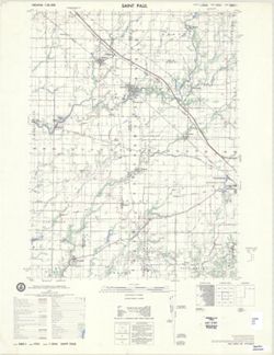
- Abstract:
- Printed with vegetation. Prepared by the U.S. Geological Survey for publication by the Defense Mapping Agency Hydrographic/Topographic Center. Variant tit...
- Call Number:
- G4090 s50 .U5 Saint Paul 1979 V
- Caption:
- Imprint: Reston, Virginia : Geological Survey, [1983] and Imprint: Washington, D.C. : Defense Mapping Agency, Hydrographic/Topographic Center, [1983]
- Physical Description:
- Dimensions: 56 x 45 cm or smaller and Scale: 1:50,000
- Alternate Identifier:
- Title Control Number: a18387946
- Persistent URL:
- https://purl.dlib.indiana.edu/iudl/images/VAC3073/VAC3073-M-01443
- Provenance:
- Part of United States. Army Map Service, Indiana 1:50,000.
-
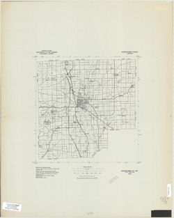
- Subject:
- Geographic Subject: Bartholomew County (Ind.)
- Creator:
- Geological Survey (U.S.)
- Publisher:
- The Survey
- Date Created:
- 1978
- Identifier:
- VAC3073-M-00963
- Genre:
- Maps
- Geographic Location:
- Coordinates: W0860530 W0854030 N0392130 N0390130
- Related URL:
- Catalog URL: https://iucat.iu.edu/catalog/5359792
- Abstract:
- Black line print. "Advance composite, subject to correction." "1978."
- Call Number:
- G4093.B3 1978 .G4
- Caption:
- Imprint: [Reston, Va.] : The Survey, [1978?]
- Physical Description:
- Dimensions: 37 x 37 cm and Scale: 1:100,000
- Alternate Identifier:
- Title Control Number: a5359792
- Persistent URL:
- https://purl.dlib.indiana.edu/iudl/images/VAC3073/VAC3073-M-00963
-
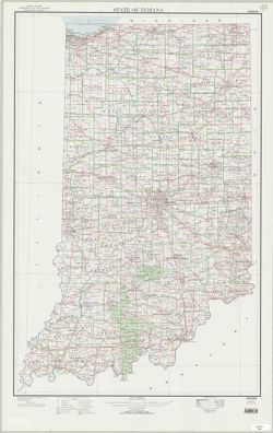
- Subject:
- Geographic Subject: Indiana
- Creator:
- Geological Survey (U.S.)
- Publisher:
- The Survey
- Date Created:
- 1977
- Identifier:
- VAC3073-M-00648
- Genre:
- Maps
- Geographic Location:
- Coordinates: W0880000 W0844500 N0414500 N0375200
- Related URL:
- Catalog URL: https://iucat.iu.edu/catalog/4898704
- Abstract:
- Shows major highways and railroads.
- Call Number:
- G4090 1973 .G46
- Caption:
- Imprint: Reston, Va. : The Survey, 1977.
- Physical Description:
- Scale: 1:500,000 and Dimensions: 93 x 61 cm
- Alternate Identifier:
- Title Control Number: a4898704
- Persistent URL:
- https://purl.dlib.indiana.edu/iudl/images/VAC3073/VAC3073-M-00648
-
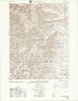
- Subject:
- Geographic Subject: Bartholomew County (Ind.) and Geographic Subject: Brown County (Ind.)
- Creator:
- United States. Defense Mapping Agency. Topographic Center and Geological Survey (U.S.)
- Publisher:
- United States. Army Map Service
- Date Created:
- 1975
- Identifier:
- VAC3073-M-01440
- Genre:
- Topographic maps, 7.5 minute topographic maps, and Quadrangle maps
- Geographic Location:
- Coordinates: W0860730 W0860000 N0391500 N0390730
- Related URL:
- Catalog URL: https://iucat.iu.edu/catalog/18376551
- Abstract:
- Printed with vegetation. Prepared by the Defense Mapping Agency Topographic Center. Variant title: Indiana 1:25,000. Filing title: New Bellsville, Indian...
- Call Number:
- G4090 s25 .U5 New Bellsville 1975 V
- Caption:
- Imprint: Washington, D.C. : Defense Mapping Agency Topographic Center, [1975]
- Physical Description:
- Dimensions: 56 x 45 cm or smaller and Scale: 1:25,000
- Alternate Identifier:
- Title Control Number: a18376551
- Persistent URL:
- https://purl.dlib.indiana.edu/iudl/images/VAC3073/VAC3073-M-01440
- Provenance:
- Part of United States. Army Map Service, Indiana 1:25,000.
-
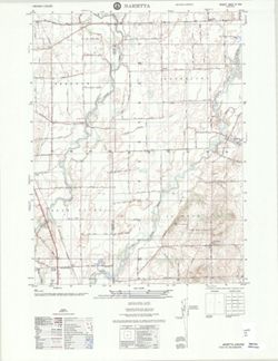
- Subject:
- Geographic Subject: Shelby County (Ind.) and Geographic Subject: Johnson County (Ind.)
- Creator:
- Geological Survey (U.S.)
- Publisher:
- United States. Defense Mapping Agency. Topographic Center
- Date Created:
- 1975
- Identifier:
- VAC3073-M-01436
- Genre:
- Topographic maps and Quadrangle maps
- Geographic Location:
- Coordinates: W0860000 W0855230 N0393000 N0392230
- Related URL:
- Catalog URL: https://iucat.iu.edu/catalog/17219142
- Abstract:
- Variant title: Indiana 1:25,000. Filing title: Marietta, Indiana. Printed with vegetation. Standard map series designation: Series V851 Sheet 3862 IV NW. Edi...
- Call Number:
- G4090 s25 .U5 Marietta 1975 V
- Caption:
- Imprint: Washington, D.C. : Defense Mapping Agency Topographic Center, 1975.
- Physical Description:
- Dimensions: 56 x 45 cm or smaller and Scale: 1:25,000
- Alternate Identifier:
- Title Control Number: a17219142
- Persistent URL:
- https://purl.dlib.indiana.edu/iudl/images/VAC3073/VAC3073-M-01436
- Provenance:
- Part of United States. Army Map Service, Indiana 1:25,000.
-
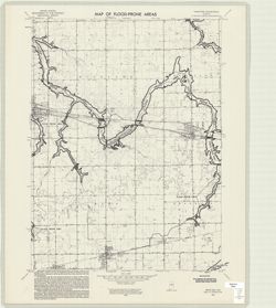
- Subject:
- Topical Subject: Floods, Geographic Subject: Miami County (Ind.), Geographic Subject: Grant County (Ind.), Topical Subject: Floodplains, Geographic Subject: ...
- Creator:
- Geological Survey (U.S.) and United States. Federal Insurance Administration
- Publisher:
- Geological Survey (U.S.)
- Date Created:
- 1974
- Identifier:
- VAC3073-M-00290
- Genre:
- Quadrangle maps, 7.5 minute topographic maps, and Topographic maps
- Geographic Location:
- Coordinates: W0855230 W0854500 N0403730 N0403000
- Related URL:
- Catalog URL: https://iucat.iu.edu/catalog/18416334
- Abstract:
- Filing title: Sweetser, Ind. Relief shown by contours and spot heights. Contour interval 10 feet. Includes quadrangle location map. Shows portion of Grant, M...
- Call Number:
- G4091.C32 s24 .G4 Sweetser, Ind. 1974
- Caption:
- Imprint: Washington, D.C. : Interior--Geological Survey, [1974]
- Physical Description:
- Dimensions: 59 x 45 or smaller and Scale: 1:24,000
- Alternate Identifier:
- Alternate ID: CAW5372BB and Title Control Number: a18416334
- Persistent URL:
- https://purl.dlib.indiana.edu/iudl/images/VAC3073/VAC3073-M-00290
- Provenance:
- United States Department of the Interior, Geological Survey. Map of flood-prone areas : [Indiana]. Washington, D.C. : The Survey, 1969-.
-
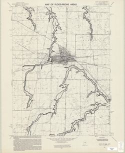
- Subject:
- Topical Subject: Floodplains, Topical Subject: Flood forecasting, Topical Subject: Floods, Geographic Subject: Darke County (Ohio), and Geographic Subject: R...
- Creator:
- Geological Survey (U.S.)
- Publisher:
- Geological Survey (U.S.)
- Date Created:
- 1974
- Identifier:
- VAC3073-M-00319
- Genre:
- Quadrangle maps, 7.5 minute topographic maps, and Topographic maps
- Geographic Location:
- Coordinates: W0845230 W0844500 N0401500 N0400730
- Related URL:
- Catalog URL: https://iucat.iu.edu/catalog/18416336
- Abstract:
- Filing title: Union City, Ind.-Ohio. Relief shown by contours and spot heights. Contour interval 10 feet. Includes quadrangle location map. Shows portions of...
- Call Number:
- G4091.C32 s24 .G4 Union City, Ind.-Ohio
- Caption:
- Imprint: Washington, D.C. : Interior--Geological Survey, [1974]
- Physical Description:
- Dimensions: 59 x 45 or smaller and Scale: 1:24,000
- Alternate Identifier:
- Alternate ID: CAW5372BB and Title Control Number: a18416336
- Persistent URL:
- https://purl.dlib.indiana.edu/iudl/images/VAC3073/VAC3073-M-00319
- Provenance:
- United States Department of the Interior, Geological Survey. Map of flood-prone areas : [Indiana]. Washington, D.C. : The Survey, 1969-.
