
Search Constraints
You searched for:
Campus
IUB
Remove constraint Campus: IUB
Date Created
1902
Remove constraint Date Created: 1902
Pages
0-99 pages
Remove constraint Pages: 0-99 pages
« Previous |
1 - 10 of 28
|
Next »
Search Results
-
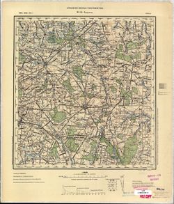
- Description:
- 1890
- Subject:
- Geographic Subject: Brzeziny, Topical Subject: Maps, and Topical Subject: Soviet Union
- Publisher:
- Управление военных топографов РККА
- Language:
- Russian
- Date Created:
- 1902
- Identifier:
- VAC9619-002725
- Genre:
- Military Maps and Topographic Maps
- Geographic Location:
- Coordinates: 51.667, 19.5, 52, 20
- Related URL:
- DataCORE Dataset Download: https://datacore.iu.edu/concern/data_sets/v692t6898
- Abstract:
- Modern area represented: Brzeziny, Łódź province, Poland
- Call Number:
- G7000 s100 .S7 sheet M-34-4
- City:
- Бжезины (Brzeziny)
- Copyright Holder:
- No Copyright - United States
- Country:
- Польша (Poland)
- Physical Description:
- Scale: 1:100,000
- Persistent URL:
- http://purl.dlib.indiana.edu/iudl/images/VAC9619/VAC9619-002725
- Provenance:
- CIA Map Library
-
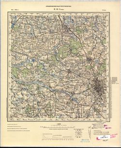
- Description:
- 1901
- Subject:
- Topical Subject: Soviet Union, Geographic Subject: Łódź, and Topical Subject: Maps
- Publisher:
- Управление военных топографов РККА
- Language:
- Russian
- Date Created:
- 1902
- Identifier:
- VAC9619-002723
- Genre:
- Topographic Maps and Military Maps
- Geographic Location:
- Coordinates: 51.667, 19, 52, 19.5
- Related URL:
- DataCORE Dataset Download: https://datacore.iu.edu/concern/data_sets/3f4626102
- Abstract:
- Modern area represented: Łódź, Łódź province, Poland
- Call Number:
- G7000 s100 .S7 sheet M-34-3
- City:
- Лодзь (Łódź)
- Copyright Holder:
- No Copyright - United States
- Country:
- Польша (Poland)
- Physical Description:
- Scale: 1:100,000
- Persistent URL:
- http://purl.dlib.indiana.edu/iudl/images/VAC9619/VAC9619-002723
- Provenance:
- CIA Map Library
-
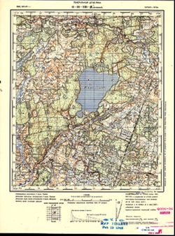
- Description:
- 1895
- Subject:
- Topical Subject: Soviet Union, Topical Subject: Maps, and Geographic Subject: Lenkimai
- Publisher:
- Генеральный штаб РККА
- Language:
- Russian
- Date Created:
- 1902
- Identifier:
- VAC9619-001753
- Genre:
- Military Maps and Topographic Maps
- Geographic Location:
- Coordinates: 56.167, 21.25, 56.333, 21.5
- Related URL:
- DataCORE Dataset Download: https://datacore.iu.edu/concern/data_sets/9880vr74b
- Abstract:
- Modern area represented: Lenkimai, Klaipėda county, Lithuania
- Call Number:
- G7000 s50 .S68 sheet O-34-139-B
- City:
- Ленкимай (Lenkimai)
- Copyright Holder:
- No Copyright - United States
- Country:
- Литва (Lithuania) and Латвия (Latvia)
- Physical Description:
- Scale: 1:50,000
- Persistent URL:
- http://purl.dlib.indiana.edu/iudl/images/VAC9619/VAC9619-001753
- Provenance:
- M. I. Map Library
-
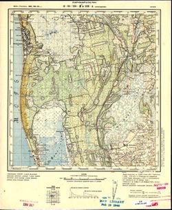
- Description:
- 1876
- Subject:
- Topical Subject: Soviet Union, Topical Subject: Maps, and Geographic Subject: Latvia
- Publisher:
- Генеральный штаб РККА
- Language:
- Russian
- Date Created:
- 1902
- Identifier:
- VAC9619-001752
- Genre:
- Military Maps and Topographic Maps
- Geographic Location:
- Coordinates: 56.167, 20.967, 56.333, 21.25
- Related URL:
- DataCORE Dataset Download: https://datacore.iu.edu/concern/data_sets/g445cf020
- Abstract:
- Modern area represented: Latvia
- Call Number:
- G7000 s50 .S68 sheet O-34-138-B
- City:
- Юрмалциэмс
- Copyright Holder:
- No Copyright - United States
- Country:
- Латвия (Latvia)
- Physical Description:
- Scale: 1:50,000
- Persistent URL:
- http://purl.dlib.indiana.edu/iudl/images/VAC9619/VAC9619-001752
- Provenance:
- CIA Map Library, M. I. Map Library
-

- Description:
- 1883
- Subject:
- Geographic Subject: Dărmăneşti, Topical Subject: Maps, and Topical Subject: Soviet Union
- Publisher:
- Генеральный штаб РККА
- Language:
- Russian
- Date Created:
- 1902
- Identifier:
- VAC9619-001707
- Genre:
- Military Maps and Topographic Maps
- Geographic Location:
- Coordinates: 44.6667, 25.5, 45, 26
- Related URL:
- DataCORE Dataset Download: https://datacore.iu.edu/concern/data_sets/c534fp662
- Abstract:
- Modern area represented: Dărmăneşti, Dâmboviţa county, Romania
- Call Number:
- G7000 s100 .S7 sheet L-35-112
- City:
- Дэрмэнешти (Dărmăneşti)
- Copyright Holder:
- No Copyright - United States
- Country:
- Румыния (Romania)
- Physical Description:
- Scale: 1:100,000
- Persistent URL:
- http://purl.dlib.indiana.edu/iudl/images/VAC9619/VAC9619-001707
- Provenance:
- DMA Topographic Center, Army Map Service Library, Library of Congress Geography & Map Division, Atlasblatt
-
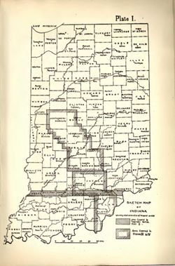
- Subject:
- Geographic Subject: Indiana and Topical Subject: IGS Annual Reports
- Publisher:
- Indiana. Department of Geology and Natural Resources
- Date Created:
- 1902
- Identifier:
- VAC3073-M-01575
- Genre:
- Index maps
- Geographic Location:
- Coordinates: W0880500 W0844700 N0414500 N0374600
- Related URL:
- Catalog URL: https://iucat.iu.edu/catalog/18418335
- Abstract:
- Index map showing locations covered by topographic maps represented on plates II-IV of the article. Shading indicates area covered by Topographic Section (Pl...
- Call Number:
- G4090 1901 .S5
- Caption:
- Imprint: [Indianapolis] : [Indiana Department of Geology and Natural Resources], [1902] and Imprint: [Indianapolis] : [Wm. B. Burford], [1902]
- Physical Description:
- Scale: Approximately 1:2,299,000 and Dimensions: on sheet 22 x 15 cm
- Alternate Identifier:
- Title Control Number: a18418335 and Alternate ID: 390726IP
- Persistent URL:
- https://purl.dlib.indiana.edu/iudl/images/VAC3073/VAC3073-M-01575
- Provenance:
- 26th Annual Report (1901) / Indiana. Department of Geology and Natural Resources.
-
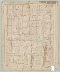
![Indiana, Ditney quadrangle [1902 printing]](https://iiif.uits.iu.edu/iiif/2/pr76g7157%2Ffiles%2F6b2150ed-f127-4bd5-ab33-87b0e9707424/full/250,/0/default.jpg)
- Subject:
- Geographic Subject: Dubois County (Ind.), Geographic Subject: Warrick County (Ind.), Geographic Subject: Vanderburgh County (Ind.), Geographic Subject: Gibso...
- Creator:
- McKinney, R. C. (Robert C.), Geological Survey (U.S.), Blair, H. B. (Herbert Buxton), 1860-1905, Renshawe, John H., and Goodlove, C. W.
- Publisher:
- Geological Survey (U.S.)
- Date Created:
- 1902
- Identifier:
- VAC3073-M-01416
- Genre:
- Quadrangle maps, 30 minute topographic maps, and Topographic maps
- Geographic Location:
- Coordinates: W0873000 W0870000 N0383000 N0380000
- Related URL:
- Catalog URL: https://iucat.iu.edu/catalog/18416043
- Abstract:
- Indiana, 30 minute series (topographic). Filing title: Ditney, Ind. Jno. H. Renshawe, geographer in charge , topography by H.B. Blair, R.C. McKinney, and Cha...
- Call Number:
- G4090 s125 .G4 Ditney 1902
- Caption:
- Imprint: [United States] : Geological Survey, [1902]
- Physical Description:
- Dimensions: 45 x 36 cm and Scale: 1:125,000
- Alternate Identifier:
- Title Control Number: a18416043
- Persistent URL:
- https://purl.dlib.indiana.edu/iudl/images/VAC3073/VAC3073-M-01416
- Provenance:
- Part of Geological Survey (U.S.). Indiana 1:125,000.
-
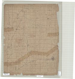
- Subject:
- Geographic Subject: Spencer County (Ind.), Geographic Subject: Dubois County (Ind.), Geographic Subject: Warrick County (Ind.), and Geographic Subject: Pike ...
- Creator:
- Renshawe, John H., Geological Survey (U.S.), Hawkins, Geo. T. (George T.), and Goodlove, C. W.
- Publisher:
- Geological Survey (U.S.)
- Date Created:
- 1902
- Identifier:
- VAC3073-M-01301
- Genre:
- 15 minute topographic maps, Topographic maps, and Quadrangle maps
- Geographic Location:
- Coordinates: W0871500 W0870000 N0381500 N0380000
- Related URL:
- Catalog URL: https://iucat.iu.edu/catalog/18408290
- Abstract:
- Engraved Oct. 1902 by U.S.G.S. , Jno. Renshawe, geographer in charge , control by Geo. T. Hawkins , topography by Chas. W. Goodlove. Filing title: Degonia Sp...
- Call Number:
- G4090 s62 .G4 Degonia Springs 1902
- Caption:
- Imprint: Washington, D.C. : The Survey, 1902
- Physical Description:
- Dimensions: 45 x 42 cm or smaller and Scale: 1:62,500
- Alternate Identifier:
- Title Control Number: a18408290
- Persistent URL:
- https://purl.dlib.indiana.edu/iudl/images/VAC3073/VAC3073-M-01301
- Provenance:
- Part of Geological Survey (U.S.). Indiana 1:62,500.
-
- Subject:
- Geographic Subject: Warrick County (Ind.), Geographic Subject: Vanderburgh County (Ind.), Geographic Subject: Gibson County (Ind.), and Geographic Subject: P...
- Creator:
- Renshawe, John H., Blair, H. B. (Herbert Buxton), 1860-1905, Hawkins, Geo. T. (George T.), and McKinney, R. C. (Robert C.)
- Publisher:
- Geological Survey (U.S.)
- Date Created:
- 1902
- Identifier:
- VAC3073-M-01296
- Genre:
- Topographic maps, Quadrangle maps, and 15 minute topographic maps
- Geographic Location:
- Coordinates: W0873000 W0871500 N0381500 N0380000
- Related URL:
- Catalog URL: https://iucat.iu.edu/catalog/18408288
- Abstract:
- Engraved Oct. 1902 by U.S.G.S. , Jno. H. Renshawe, geographer in charge , control by Geo. T. Hawkins , topography by R.C. McKinney and H.B. Blair. Edition of...
- Call Number:
- G4090 s62 .G4 Boonville 1902
- Caption:
- Imprint: [Washington, D.C.] : U.S. Geological Survey, 1902
- Physical Description:
- Dimensions: 45 x 42 cm or smaller and Scale: 1:62,500
- Alternate Identifier:
- Title Control Number: a18408288
- Persistent URL:
- https://purl.dlib.indiana.edu/iudl/images/VAC3073/VAC3073-M-01296
- Provenance:
- Part of Geological Survey (U.S.). Indiana 1:62,500.
-
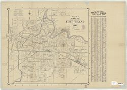
- Subject:
- Geographic Subject: Fort Wayne (Ind.)
- Creator:
- R.L. Polk & Co.
- Publisher:
- R.L. Polk & Co.
- Date Created:
- 1902
- Identifier:
- VAC3073-M-00897
- Genre:
- Maps
- Geographic Location:
- Coordinates: W0851811 W0845955 N0411159 N0405755
- Related URL:
- Catalog URL: https://iucat.iu.edu/catalog/7478796
- Abstract:
- Includes distance circles and street index.
- Call Number:
- G4094.F7 1902 .R2
- Caption:
- Imprint: Fort Wayne, Ind. : R.L. Polk & Co., 1902.
- Physical Description:
- Dimensions: 54 x 60 cm, on sheet 63 x 91 cm and Scale: 1:10,900
- Alternate Identifier:
- Title Control Number: a7478796
- Persistent URL:
- https://purl.dlib.indiana.edu/iudl/images/VAC3073/VAC3073-M-00897

- « Previous
- Next »
- 1
- 2
- 3