Indiana University
Indiana University
IU
Skip to Content
Digital Collections
Toggle navigation
Digital
Collections
Switch language
English
Switch language
Deutsch
English
Español
Français
Italiano
Português do Brasil
中文
Login
Home
About
Contact
Search Digital Collections
Go
×
Search Constraints
Start Over
You searched for:
Date Created
1911
Remove constraint Date Created: 1911
Holding Location
B-WELLS
Remove constraint Holding Location: B-WELLS
« Previous |
1
-
10
of
12
|
Next »
Sort by relevance ▼
relevance ▼
recently updated
title ▲
title ▼
date created ▲
date created ▼
pages ▲
pages ▼
collection size ▲
collection size ▼
Number of results to display per page
10 per page
10
per page
20
per page
50
per page
100
per page
View results as:
List
Gallery
Masonry
Search Results
1.
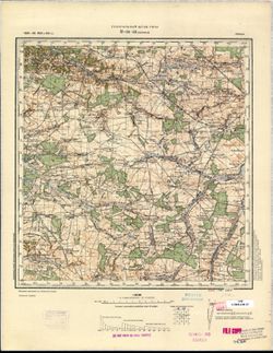
N-34-54 Пр. Айлау
2.
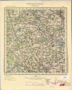
M-34-33 Бэлжицэ
3.
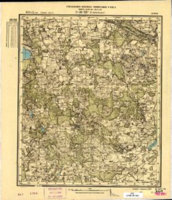
M-34-8 Гарволин
4.
О-34-131-А Яунсэсавас
5.
О-34-130-А Таурукални
6.
O-34-119-C Джукстэ
7.
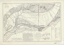
Ohio River : Pittsburgh, Pa. to mouth in 280 charts and index sheet
8.
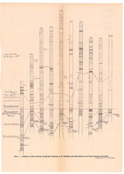
Columnar sections showing stratigraphic relationships of the Mansfield and Huron rocks in the eastern interior coal basin
9.
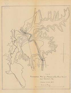
Topographic map of a portion of Eel River Valley near Cataract, Ind.
10.
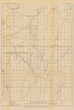
Map of the Oakland City, Indiana, oil field, December 1, 1910
« Previous
Next »
1
2
Toggle facets
Limit your search
Type
Image
12
Creator
Blatchley, Raymond S. (Raymond Sillliman)
1
United States. Army. Corps of Engineers
1
Subject
Topical Subject: Maps
6
Topical Subject: Soviet Union
6
Topical Subject: IGS Annual Reports
5
Geographic Subject: Indiana
2
Topical Subject: Rivers
2
Topical Subject: Valleys
2
Geographic Subject: Bagrationovsk
1
Geographic Subject: Bełżyce
1
Geographic Subject: Džūkste
1
Geographic Subject: Eel River Valley (Ind. : Valley)
1
more
Subjects
»
Language
Russian
6
Publisher
Indiana. Department of Geology and Natural Resources
5
Генеральный штаб РККА
3
Управление военных топографов РККА
2
U.S. Lake Survey
1
Управление военных топографов
1
Date Created
1911
[remove]
12
Pages
0-99 pages
12
Collections
Indiana Historic Maps
6
Russian Military Topographic Map Collection
6
State
deposited
12
Campus
IUB
12
City
Бэлжицэ (Bełżyce)
1
Гарволин (Garwolin)
1
Джукстэ (Džūkste)
1
Пр. Айлау (Preußisch Eylau)
1
Таурукални (Towrukalni)
1
Яунсэсавас (Jaunszsavas)
1
Country
Латвия (Latvia)
3
Польша (Poland)
2
State/Province
Восточная Пруссия (East Prussia)
1
Кенигсбергская провинция (Königsberg province)
1
Holding Location
B-WELLS
[remove]
12
Provenance
35th Annual Report (1910) / Indiana. Department of Geology and Natural Resources.
5
CIA Map Branch -- Received
1
CIA Map Library
1
CIA Map Library, Justus Perthes Kartensammlung
1
DMA Topographic Center, Army Map Service Library, OMAHA
1
M. I. Map Library
1
M. I. Map Library, G000-30, GS, RA
1