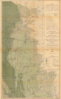
Sheets included NE sheet, NW sheet, SE sheet, SW sheet Glossy photograph on Kodak paper. Reproduction of a printed map. Reproduced by John Robbins, a f...
Call Number:
G4093.M7 1895 .S543 NE sheet
Physical Description:
Dimensions: 81 x 64 cm, on sheets 51 x 41 cm and Scale: Approximately 1:52,000
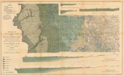
Relief shown by spot heights. Includes map showing the location of coal locations, coal features, and railroads, as well as geological cross sections for sev...
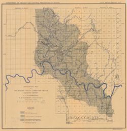
Call Number:
G4093.S8H9 1898 .A84
Caption:
Imprint: Indianapolis, Ind. : Wm. B. Burford, [1899]
Physical Description:
Scale: Approximately 1:126,720. 2 miles = 1 inch. Vertical scale approximately 1:4,800. 1 inch = 400 feet and Dimensions: 48 x 78 cm
Alternate Identifier:
Alternate ID: 390726IP and Title Control Number: a18265344
Relief shown by spot heights. Includes map showing coal locations and features, railroads, and quarries as well as vertical cross sections for Dana to Portla...
Call Number:
G4093.V5H9 1898 .A84
Caption:
Imprint: Indianapolis, Ind. : Wm. B. Burford, [1899]
Physical Description:
Scale: Approximately 1:126,720. 2 miles = 1 inch and Dimensions: 48 x 77 cm
Alternate Identifier:
Alternate ID: 390726IP and Title Control Number: a18259650
"NOTE - The eastern outcrop of the Knobstone is from map by Ind. Univ. Geol. Surv. Eastern outcrop of Devonian surveyed by J. A. Price. Eastern outcrop ...
Call Number:
G4091.H5 1900 .S54
Caption:
Imprint: Indianapolis, Ind. : Wm. B. Burford, Lith., [1901]
Physical Description:
Scale: Approximately 1:126,720. 2 miles = 1 inch and Dimensions: 47 x 38 cm
Alternate Identifier:
Title Control Number: a18188442 and Alternate ID: 390726IP
Topical Subject: Limestone, Topical Subject: Geology, Geographic Subject: Owen County (Ind.), Geographic Subject: Monroe County (Ind.), and Topical Subject: ...
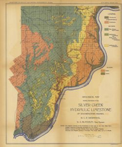
Creator:
Siebenthal, C. E. (Claude Ellsworth), 1869-1930
Publisher:
Indiana. Department of Geology and Natural Resources
Also shows location of lacustral, Mitchell limestone, and Harrodsburg limestone as well as those of abandoned quarries and the southern limit of glacial drif...
Call Number:
G4093.M7H5 1907 .S5
Caption:
Imprint: [Indianapolis] : [Indiana Dept. of Geology and Natural Resources], [1908]
Physical Description:
Scale: Approximately 1:126,720. 2 miles = 1 inches and Dimensions: 44 x 25 cm
Alternate Identifier:
Alternate ID: 390726IP and Title Control Number: a18307460
Geographic Subject: Putnam County (Ind.), Geographic Subject: Benton County (Ind.), Geographic Subject: Fountain County (Ind.), Geographic Subject: Newton Co...
Creator:
Ashley, Geo. H. (George Hall), 1866-1951, Siebenthal, C. E. (Claude Ellsworth), 1869-1930, and Kindle, E. M. (Edward Martin), 1869-1940
Publisher:
Indiana. Department of Geology and Natural Resources
Relief shown by spot heights. Includes map showing coal locations and features, railroads, and quarries as well as two inset maps for parts of Newton and Ben...
Call Number:
G4093.W3H9 1898 .A84
Caption:
Imprint: Indianapolis, Ind. : Wm. B. Burford, [1899]
Physical Description:
Dimensions: 79 x 48 cm and Scale: Approximately 1:126,720. 2 miles = 1 inch
Alternate Identifier:
Alternate ID: 390726IP and Title Control Number: a18265361
Also shows locations of Mitchell and Harrodsburg limestones as well as abandoned quarries in Lawrence County and small parts of Orange, Washington, and Jacks...
Call Number:
G4093.L5H5 1907 .S5
Caption:
Imprint: [Indianapolis] : [Indiana Dept. of Geology and Natural Resources], [1908]
Physical Description:
Dimensions: 32 x 31 cm and Scale: Approximately 1:126,720. 2 miles = 1 inches
Alternate Identifier:
Title Control Number: a18307475 and Alternate ID: 390726IP
Geographic Subject: Monroe County (Ind.), Topical Subject: Roads, and Topical Subject: Quarries and quarrying
Creator:
Siebenthal, C. E. (Claude Ellsworth), 1869-1930
Publisher:
Julius Bien & Co.
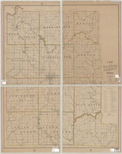
Date Created:
1895
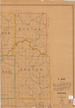
Identifier:
VAC3073-M-00084
Genre:
Road maps and Thematic maps
Geographic Location:
Coordinates: W0864108 W0862436 N0392120 N0385926
Related URL:
Catalog URL: https://iucat.iu.edu/catalog/5101345
Abstract:
Shows townships, sections, drainage, roads, schools, post offices, quarries, and stone mills. Includes "Stone directory" listing quarries and the c...