
Search Constraints
You searched for:
Publisher
Geological Survey (U.S.)
Remove constraint Publisher: Geological Survey (U.S.)
Search Results
-
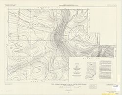
- Subject:
- Topical Subject: Geomagnetism and Geographic Subject: Fulton County (Ind.)
- Creator:
- Dempsey, W. J.
- Publisher:
- Geological Survey (U.S.)
- Date Created:
- 1949
- Identifier:
- VAC3073-M-00853
- Genre:
- Thematic maps
- Geographic Location:
- Coordinates: W0862806 W0855643 N0411022 N0405432
- Related URL:
- Catalog URL: https://iucat.iu.edu/catalog/6942523
- Abstract:
- Includes text and location map.
- Call Number:
- G4093.F8C93 1949 .D4
- Caption:
- Imprint: [Washington, D.C.] : For sale by U.S. Geological Survey, 1949.
- Physical Description:
- Dimensions: 48 x 71 cm and Scale: 1:75,600
- Alternate Identifier:
- Title Control Number: a6942523
- Persistent URL:
- https://purl.dlib.indiana.edu/iudl/images/VAC3073/VAC3073-M-00853
-
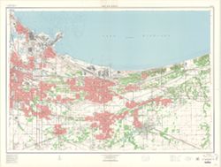
- Subject:
- Geographic Subject: Gary (Ind.)
- Creator:
- Geological Survey (U.S.)
- Publisher:
- Geological Survey (U.S.)
- Date Created:
- 1963
- Identifier:
- VAC3073-M-00008
- Genre:
- Topographic maps
- Geographic Location:
- Coordinates: W0872601 W0871319 N0413903 N0413118
- Related URL:
- Catalog URL: https://iucat.iu.edu/catalog/5591989
- Abstract:
- Relief shown by contours and spot heights. Depths by contours and soundings. "Contour interval 5 and 10 feet." Red tint indicates areas in which on...
- Call Number:
- G4094.G2 1960 .G4
- Caption:
- Imprint: Washington, D.C.: U.S.Geological Survey, 1960.
- Physical Description:
- Dimensions: 101 x 144 cm and Scale: 1:24,000
- Alternate Identifier:
- Title Control Number: a5591989
- Persistent URL:
- https://purl.dlib.indiana.edu/iudl/images/VAC3073/VAC3073-M-00008
-
![Illinois-Indiana-Kentucky, New Haven quadrangle : topography [1920 reprint without vegetation]](https://iiif.uits.iu.edu/iiif/2/pz50hz88n%2Ffiles%2Ff9ee1b77-e188-458e-ba78-5dd112ba1556/full/250,/0/default.jpg)
- Subject:
- Geographic Subject: Posey County (Ind.), Geographic Subject: White County (Ill.), and Geographic Subject: Gallatin County (Ill.)
- Creator:
- Lloyd, W. J. (Topographer), Kentucky Geological Survey, Smith, L. Scott, Ellis, J. R. (Topographer), Cooke, Chas. E. (Charles E.), Illinois State Geological ...
- Publisher:
- Geological Survey (U.S.)
- Date Created:
- 1920
- Identifier:
- VAC3073-M-01358
- Genre:
- Topographic maps, 15 minute topographic maps, and Quadrangle maps
- Geographic Location:
- Coordinates: W0881500 W0880000 N0380000 N0374500
- Related URL:
- Catalog URL: https://iucat.iu.edu/catalog/18413857
- Abstract:
- H. M. Wilson, chief geographer , Chas. E. Cooke, in charge of section , topography by W. J. Lloyd and L. Scott Smith , control by J. R. Ellis , engraved Aug....
- Call Number:
- G4090 s62 .G4 New Haven 1906 rep 1920
- Caption:
- Imprint: [Lexington, Ky.] : Geological Survey, 1920, Imprint: [Urbana, Ill.] : Geological Survey Division, and Imprint: [Washington, D.C.] : U.S. Geological ...
- Physical Description:
- Dimensions: 45 x 42 cm or smaller and Scale: 1:62,500
- Alternate Identifier:
- Title Control Number: a18413857
- Persistent URL:
- https://purl.dlib.indiana.edu/iudl/images/VAC3073/VAC3073-M-01358
- Provenance:
- Part of Geological Survey (U.S.). Indiana 1:62,500.
-
![Indiana Clay City quadrangle [1936 reprint]](https://iiif.uits.iu.edu/iiif/2/wd376z59h%2Ffiles%2Faa45c1aa-fb05-4809-a96b-7abd27014bc5/full/250,/0/default.jpg)
- Subject:
- Geographic Subject: Vigo County (Ind.), Geographic Subject: Putnam County (Ind.), Geographic Subject: Clay County (Ind.), and Geographic Subject: Owen County...
- Creator:
- Sadler, C. L., Marshall, R. B. (Robert Bradford), 1867-1949, Geological Survey (U.S.), and Herron, W. H. (William Harrison), 1865-
- Publisher:
- Geological Survey (U.S.)
- Date Created:
- 1936
- Identifier:
- VAC3073-M-01323
- Genre:
- Quadrangle maps, 15 minute topographic maps, and Topographic maps
- Geographic Location:
- Coordinates: W0871500 W0870000 N0393000 N0391500
- Related URL:
- Catalog URL: https://iucat.iu.edu/catalog/a18406394
- Abstract:
- Engraved July 1910 by U.S.G.S. , R. B. Marshall, chief geographer , W. H. Herron, geographer in charge , topography by C. L. Sadler , [and three others]. Rel...
- Call Number:
- G4090 s62 .G4 Clay City 1910 rep1936
- Caption:
- Imprint: [Washington, D.C.] : U.S. Geological Survey, 1936
- Physical Description:
- Scale: 1:62,500 and Dimensions: 45 x 42 cm or smaller
- Alternate Identifier:
- Title Control Number: a18406394
- Persistent URL:
- https://purl.dlib.indiana.edu/iudl/images/VAC3073/VAC3073-M-01323
- Provenance:
- Part of Geological Survey (U.S.). Indiana 1:62,500.
-
![Indiana Degonia Springs quadrangle [1936 reprint]](https://iiif.uits.iu.edu/iiif/2/x346f640t%2Ffiles%2F0b272452-2a1a-4415-897a-e57e4a8c1f70/full/250,/0/default.jpg)
- Subject:
- Geographic Subject: Warrick County (Ind.), Geographic Subject: Dubois County (Ind.), Geographic Subject: Spencer County (Ind.), and Geographic Subject: Pike ...
- Creator:
- Renshawe, John H., Goodlove, C. W., Geological Survey (U.S.), and Hawkins, Geo. T. (George T.)
- Publisher:
- Geological Survey (U.S.)
- Date Created:
- 1936
- Identifier:
- VAC3073-M-01293
- Genre:
- 15 minute topographic maps, Topographic maps, and Quadrangle maps
- Geographic Location:
- Coordinates: W0871500 W0870000 N0381500 N0380000
- Related URL:
- Catalog URL: https://iucat.iu.edu/catalog/18408290
- Abstract:
- Engraved Oct. 1902 by U.S.G.S. , Jno. Renshawe, geographer in charge , control by Geo. T. Hawkins , topography by Chas. W. Goodlove. Filing title: Degonia Sp...
- Call Number:
- G4090 s62 .G4 Degonia Springs 1902 rep1936
- Caption:
- Imprint: [Washington, D.C.] : U.S. Geological Survey, 1936
- Physical Description:
- Scale: 1:62,500 and Dimensions: 45 x 42 cm or smaller
- Alternate Identifier:
- Title Control Number: a18408290
- Persistent URL:
- https://purl.dlib.indiana.edu/iudl/images/VAC3073/VAC3073-M-01293
- Provenance:
- Part of Geological Survey (U.S.). Indiana 1:62,500.
-
- Subject:
- Geographic Subject: Jackson County (Ind.), Geographic Subject: Lawrence County (Ind.), Geographic Subject: Washington County (Ind.), and Geographic Subject: ...
- Creator:
- Geological Survey (U.S.) and Kilmartin, J. O. (Jerome O'Farrell), 1900-1979
- Publisher:
- Geological Survey (U.S.)
- Date Created:
- 1937
- Identifier:
- VAC3073-M-01314
- Genre:
- Topographic maps, Quadrangle maps, and 15 minute topographic maps
- Geographic Location:
- Coordinates: W0863000 W0861500 N0390000 N0384500
- Related URL:
- Catalog URL: https://iucat.iu.edu/catalog/18408529
- Abstract:
- Topography by J. O. Kilmartin, Shirley Waggener, W. H. Austin, G. G. Martin, and C. W. Birdseye. Polyconic projection. Relief shown by contours and spot heig...
- Call Number:
- G4090 s62 .G4 Bedford 1937
- Caption:
- Imprint: Washington, D.C. : U.S. Dept. of the Interior, Geological Survey, 1937.
- Physical Description:
- Scale: 1:62,500 and Dimensions: 45 x 42 cm or smaller
- Alternate Identifier:
- Title Control Number: a18408529
- Persistent URL:
- https://purl.dlib.indiana.edu/iudl/images/VAC3073/VAC3073-M-01314
- Provenance:
- Part of Geological Survey (U.S.). Indiana 1:62,500.
-
![Indiana-Kentucky Corydon quadrangle [1931 printing]](https://iiif.uits.iu.edu/iiif/2/vq280r404%2Ffiles%2F2b715af8-dded-4de4-a4e3-8e1c86dcc800/full/250,/0/default.jpg)
- Subject:
- Geographic Subject: Meade County (Ky.)
- Creator:
- Kentucky Geological Survey, Higginson, W. S. (William Smith Muir), 1894-1984, United States. Army, and Geological Survey (U.S.)
- Publisher:
- Geological Survey (U.S.)
- Date Created:
- 1931
- Identifier:
- VAC3073-M-01321
- Genre:
- 15 minute topographic maps, Topographic maps, and Quadrangle maps
- Geographic Location:
- Coordinates: W0861500 W0860000 N0381500 N0380000
- Related URL:
- Catalog URL: https://iucat.iu.edu/catalog/18406398
- Abstract:
- Topography by W.S. Higginson , Ohio River by Corps of Engineers, U.S. Army , control by U.S. Geological Survey and Corps of Engineers, U.S. Army. Filing titl...
- Call Number:
- G4090 s62 .G4 Corydon 1931
- Caption:
- Imprint: [Washington, D.C.] : Dept. of the Interior, U.S. Geological Survey, [1931]
- Physical Description:
- Scale: 1:62,500 and Dimensions: 45 x 42 cm or smaller
- Alternate Identifier:
- Title Control Number: a18406398
- Persistent URL:
- https://purl.dlib.indiana.edu/iudl/images/VAC3073/VAC3073-M-01321
- Provenance:
- Part of Geological Survey (U.S.). Indiana 1:62,500.
-
![Indiana Haubstadt quadrangle [1903 printing]](https://iiif.uits.iu.edu/iiif/2/mw22w891g%2Ffiles%2F3f2a82be-5754-4703-989d-ede2f3a3b596/full/250,/0/default.jpg)
- Subject:
- Geographic Subject: Posey County (Ind.), Geographic Subject: Gibson County (Ind.), and Geographic Subject: Vanderburgh County (Ind.)
- Creator:
- Renshawe, John H., Goodlove, C. W., Hawkins, Geo. T. (George T.), and Geological Survey (U.S.)
- Publisher:
- Geological Survey (U.S.)
- Date Created:
- 1903
- Identifier:
- VAC3073-M-01342
- Genre:
- Quadrangle maps, 15 minute topographic maps, and Topographic maps
- Geographic Location:
- Coordinates: W0874500 W0873000 N0381500 N0380000
- Related URL:
- Catalog URL: https://iucat.iu.edu/catalog/18408287
- Abstract:
- Engraved Mar. 1903 by U.S.G.S. , Jno. H. Renshawe, geographer in charge , control by Geo. T. Hawkins , topography by Chas. W. Goodlove. Relief shown by conto...
- Call Number:
- G4090 s62 .G4 Haubstadt 1903
- Caption:
- Imprint: [Washington, D.C.] : U.S. Geological Survey, 1903
- Physical Description:
- Dimensions: 45 x 42 cm or smaller and Scale: 1:62,500
- Alternate Identifier:
- Title Control Number: a18408287
- Persistent URL:
- https://purl.dlib.indiana.edu/iudl/images/VAC3073/VAC3073-M-01342
- Provenance:
- Part of Geological Survey (U.S.). Indiana 1:62,500.
-
![Hutsonville quadrangle, Illinois-Indiana : 15 minute series (topographic) [1957 printing with vegetation]](https://iiif.uits.iu.edu/iiif/2/3j334584p%2Ffiles%2F2e66aa9a-552c-48aa-af5a-e5cdae6d7b8f/full/250,/0/default.jpg)
- Subject:
- Geographic Subject: Crawford County (Ill.), Geographic Subject: Sullivan County (Ind.), Topical Subject: Vegetation mapping, and Geographic Subject: Clark Co...
- Creator:
- Geological Survey (U.S.), Indiana. Department of Conservation, and Illinois State Geological Survey
- Publisher:
- Geological Survey (U.S.)
- Date Created:
- 1957
- Identifier:
- VAC3073-M-01346
- Genre:
- 15 minute topographic maps, Topographic maps, and Quadrangle maps
- Geographic Location:
- Coordinates: W0874500 W0873000 N0391500 N0390000
- Related URL:
- Catalog URL: https://iucat.iu.edu/catalog/18408296
- Abstract:
- Mapped, edited, and published by the Geological Survey , control by USGS, USC & GS, and USCE. Filing title: Hutsonville, Ill.-Ind. Standard map series de...
- Call Number:
- G4090 s62 .G4 Hutsonville 1957
- Caption:
- Imprint: Indianapolis, Ind. : Indiana Department of Conservation, [1958], Imprint: Washington, D.C. : for sale by U.S. Geological Survey, Imprint: Urbana, Il...
- Physical Description:
- Dimensions: 45 x 42 cm or smaller and Scale: 1:62,500
- Alternate Identifier:
- Title Control Number: a18408296
- Persistent URL:
- https://purl.dlib.indiana.edu/iudl/images/VAC3073/VAC3073-M-01346
- Provenance:
- Part of Geological Survey (U.S.). Indiana 1:62,500.
-
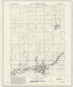
- Subject:
- Topical Subject: Flood forecasting, Geographic Subject: Madison County (Ind.), Topical Subject: Floods, Geographic Subject: Alexandria Region (Ind.), and Top...
- Creator:
- Geological Survey (U.S.)
- Publisher:
- Geological Survey (U.S.)
- Date Created:
- 1970
- Identifier:
- VAC3073-M-00162
- Genre:
- 7.5 minute topographic maps, Topographic maps, and Quadrangle maps
- Geographic Location:
- Coordinates: W0854500 W0853730 N0402230 N0401500
- Related URL:
- Catalog URL: https://iucat.iu.edu/catalog/18416051
- Abstract:
- Filing title: Alexandria, Ind. Relief shown by contours and spot heights. Contour interval 10 feet. Includes quadrangle location map. Flood prone areas and o...
- Call Number:
- G4091.C32 s24 .G4 Alexandria 1970
- Caption:
- Imprint: Washington, D.C. : Interior--Geological Survey, [1970]
- Physical Description:
- Scale: 1:24,000 and Dimensions: 59 x 45 or smaller
- Alternate Identifier:
- Alternate ID: CAW5372BB and Title Control Number: a18416051
- Persistent URL:
- https://purl.dlib.indiana.edu/iudl/images/VAC3073/VAC3073-M-00162
- Provenance:
- United States Department of the Interior, Geological Survey. Map of flood-prone areas : [Indiana]. Washington, D.C. : The Survey, 1969-.
