
Search Constraints
You searched for:
Campus
IUB
Remove constraint Campus: IUB
Date Created
1939
Remove constraint Date Created: 1939
Holding Location
B-WELLS
Remove constraint Holding Location: B-WELLS
« Previous |
1 - 50 of 95
|
Next »
Search Results
-
- Description:
- 1939
- Subject:
- Geographic Subject: Polyana and Topical Subject: Soviet Union
- Publisher:
- Главное управление геодезии и картографии при СНК СССР
- Language:
- Russian
- Date Created:
- 1939
- Identifier:
- VAC9619-000007
- Genre:
- Topographic Maps and Military Maps
- Geographic Location:
- Coordinates: 59.6667, 31.25, 59.8333, 31.5
- Related URL:
- Catalog URL: http://iucat.iu.edu/catalog/5020131 and Download GeoTIFF: https://drive.google.com/open?id=1QhVDxDghHww023dj3SHGuFISgFPnOpeM
- Abstract:
- Modern area represented: Polyana, Russia
- Call Number:
- G7000 s50 .S68 sheet O-36-3-D
- City:
- Поляна (Polyana)
- Copyright Holder:
- No Copyright - United States
- Country:
- СССР (USSR)
- State/Province:
- Ленинградская область (Leningrad oblast), Мгинский район (Mginsky district), and РСФСР (RSFSR)
- Physical Description:
- Scale: 1:50,000
- Persistent URL:
- http://purl.dlib.indiana.edu/iudl/images/VAC9619/VAC9619-000007
- Provenance:
- Army Map Service Library, OMAHA, Library of Congress Geography & Map Division
-
- Subject:
- Topical Subject: Real property, Geographic Subject: Washington (Monroe County, Ind. : Township), and Topical Subject: Landowners
- Creator:
- Stevens, Katherine (Mapmaker)
- Publisher:
- Stevens, Katherine (Mapmaker)
- Date Created:
- 1939
- Identifier:
- VAC3073-M-01525
- Genre:
- Cadastral maps
- Geographic Location:
- Coordinates: W0863534 W0862752 N0392013 N0391503
- Related URL:
- Catalog URL: https://iucat.iu.edu/catalog/18408369
- Abstract:
- Made by Katherine Stevens. Title in lower right corner: Plat #2, Washington Twp. Shows roads, creeks, churches, cemeteries, schools, and owner names with acr...
- Call Number:
- G4093.M7G46 1939 .S74 Washington
- Caption:
- Imprint: Bloomington, Indiana : Katherine Stevens, [1939]
- Physical Description:
- Scale: Approximately 1:18,000. 1,500 feet = 1 inch and Dimensions: on sheet 92 x 59 cm
- Alternate Identifier:
- Title Control Number: a18408369
- Persistent URL:
- https://purl.dlib.indiana.edu/iudl/images/VAC3073/VAC3073-M-01525
- Provenance:
- Katherine Stevens. Township maps of Monroe County, Indiana, [1939]
-
- Subject:
- Topical Subject: Real property, Topical Subject: Landowners, and Geographic Subject: Van Buren (Monroe County, Ind. : Township)
- Creator:
- Stevens, Katherine (Mapmaker)
- Publisher:
- Stevens, Katherine (Mapmaker)
- Date Created:
- 1939
- Identifier:
- VAC3073-M-01526
- Genre:
- Cadastral maps
- Geographic Location:
- Coordinates: W0864055 W0863423 N0390953 N0390446
- Related URL:
- Catalog URL: https://iucat.iu.edu/catalog/18408348
- Abstract:
- Made by Katherine Stevens. Title in lower right corner: Plat #7, Van Buren Twp. Shows roads, creeks, churches, cemeteries, schools, and owner names with acre...
- Call Number:
- G4093.M7G46 1939 .S74 Van Buren
- Caption:
- Imprint: Bloomington, Indiana : Katherine Stevens, [1939]
- Physical Description:
- Dimensions: on sheet 92 x 59 cm and Scale: Approximately 1:18,000. 1,500 feet = 1 inch
- Alternate Identifier:
- Title Control Number: a18408348
- Persistent URL:
- https://purl.dlib.indiana.edu/iudl/images/VAC3073/VAC3073-M-01526
- Provenance:
- Katherine Stevens. Township maps of Monroe County, Indiana, [1939]
-
- Subject:
- Topical Subject: Real property, Topical Subject: Landowners, and Geographic Subject: Salt Creek (Monroe County, Ind. : Township)
- Creator:
- Stevens, Katherine (Mapmaker)
- Publisher:
- Stevens, Katherine (Mapmaker)
- Date Created:
- 1939
- Identifier:
- VAC3073-M-01519
- Genre:
- Cadastral maps
- Geographic Location:
- Coordinates: W0862738 W0862209 N0390953 N0390440
- Related URL:
- Catalog URL: https://iucat.iu.edu/catalog/18408344
- Abstract:
- Made by Katherine Stevens. Title in lower right corner: Plat #9, Salt Creek Twp. Shows roads, creeks, churches, cemeteries, schools, and owner names with acr...
- Call Number:
- G4093.M7G46 1939 .S74 Salt Creek
- Caption:
- Imprint: Bloomington, Indiana : Katherine Stevens, [1939]
- Physical Description:
- Scale: 1:18,000. 1,500 feet = 1 inch and Dimensions: on sheet 92 x 59 cm
- Alternate Identifier:
- Title Control Number: a18408344
- Persistent URL:
- https://purl.dlib.indiana.edu/iudl/images/VAC3073/VAC3073-M-01519
- Provenance:
- Katherine Stevens. Township maps of Monroe County, Indiana, [1939]
-
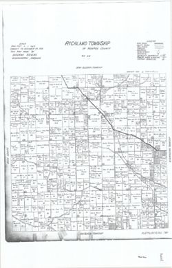
- Subject:
- Geographic Subject: Richland (Monroe County, Ind. : Township), Topical Subject: Real property, and Topical Subject: Landowners
- Creator:
- Stevens, Katherine (Mapmaker)
- Publisher:
- Stevens, Katherine (Mapmaker)
- Date Created:
- 1939
- Identifier:
- VAC3073-M-01518
- Genre:
- Cadastral maps
- Geographic Location:
- Coordinates: W0864102 W0863423 N0391509 N0390951
- Related URL:
- Catalog URL: https://iucat.iu.edu/catalog/18409340
- Abstract:
- Made by Katherine Stevens. Title in lower right corner: Plat #4, Richland Twp. Shows roads, creeks, railroads, churches, cemeteries, schools, and owner names...
- Call Number:
- G4093.M7G46 1939 .S74 Richland
- Caption:
- Imprint: Bloomington, Indiana : Katherine Stevens, [1939]
- Physical Description:
- Dimensions: on sheet 92 x 59 cm and Scale: Approximately 1:18,000. 1,500 feet = 1 inch
- Alternate Identifier:
- Title Control Number: a18409340
- Persistent URL:
- https://purl.dlib.indiana.edu/iudl/images/VAC3073/VAC3073-M-01518
- Provenance:
- Katherine Stevens. Township maps of Monroe County, Indiana, [1939]
-
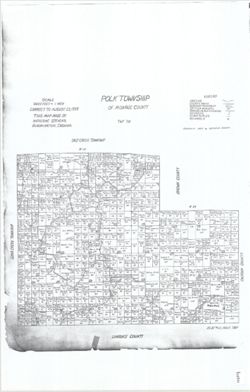
- Subject:
- Geographic Subject: Polk (Monroe County, Ind. : Township), Topical Subject: Landowners, and Topical Subject: Real property
- Creator:
- Stevens, Katherine (Mapmaker)
- Publisher:
- Stevens, Katherine (Mapmaker)
- Date Created:
- 1939
- Identifier:
- VAC3073-M-01516
- Genre:
- Cadastral maps
- Geographic Location:
- Coordinates: W0862741 W0861901 N0390447 N0385936
- Related URL:
- Catalog URL: https://iucat.iu.edu/catalog/18408242
- Abstract:
- Made by Katherine Stevens. Title in lower right corner: Plat #12, Polk Twp. Shows roads, creeks, churches, cemeteries, schools, and owner names with acreage....
- Call Number:
- G4093.M7G46 1939 .S74 Polk
- Caption:
- Imprint: Bloomington, Indiana : Katherine Stevens, [1939]
- Physical Description:
- Scale: 1:18,000. 1,500 feet = 1 inch and Dimensions: on sheet 92 x 59 cm
- Alternate Identifier:
- Title Control Number: a18408242
- Persistent URL:
- https://purl.dlib.indiana.edu/iudl/images/VAC3073/VAC3073-M-01516
- Provenance:
- Katherine Stevens. Township maps of Monroe County, Indiana, [1939]
-
- Subject:
- Geographic Subject: Pike County (Ind.), Topical Subject: Real property, and Topical Subject: Landowners
- Creator:
- Skinner, John, of Winslow, Indiana
- Publisher:
- Skinner, John, of Winslow, Indiana
- Date Created:
- 1939
- Identifier:
- VAC3073-M-01276
- Genre:
- Cadastral maps
- Geographic Location:
- Coordinates: W0872751 W0870420 N0383309 N0381355
- Related URL:
- Catalog URL: https://iucat.iu.edu/catalog/18455588
- Abstract:
- Variant title: Pike County, Indiana. Winslow, Indiana. Shows private and corporate landownership, roads, railroads, and shy ditches. "John Skinner, Wins...
- Caption:
- Imprint: [Winslow, Ind.?] : [John Skinner], [1939]
- Physical Description:
- Scale: Approximately 1:31,680. 2" = 1 mile and Dimensions: 110 x 108 cm, on sheet 118 x 113 cm
- Alternate Identifier:
- Title Control Number: a18455588
- Persistent URL:
- https://purl.dlib.indiana.edu/iudl/images/VAC3073/VAC3073-M-01276
-
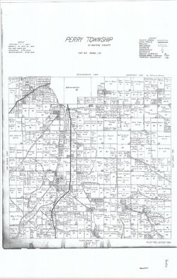
- Subject:
- Geographic Subject: Perry (Monroe County, Ind. : Township), Topical Subject: Real property, and Topical Subject: Landowners
- Creator:
- Stevens, Katherine (Mapmaker)
- Publisher:
- Stevens, Katherine (Mapmaker)
- Date Created:
- 1939
- Identifier:
- VAC3073-M-01521
- Genre:
- Cadastral maps
- Geographic Location:
- Coordinates: W0863423 W0862741 N0390952 N0390531
- Related URL:
- Catalog URL: https://iucat.iu.edu/catalog/18409336
- Abstract:
- Made by Katherine Stevens. Title in lower right corner: Plat #8, Perry Twp. Shows roads, creeks, railroads, churches, cemeteries, schools, and owner names wi...
- Call Number:
- G4093.M7G46 1939 .S74 Perry
- Caption:
- Imprint: Bloomington, Indiana : Katherine Stevens, [1939]
- Physical Description:
- Scale: Approximately 1:18,000. 1,500 feet = 1 inch and Dimensions: on sheet 92 x 59 cm
- Alternate Identifier:
- Title Control Number: a18409336
- Persistent URL:
- https://purl.dlib.indiana.edu/iudl/images/VAC3073/VAC3073-M-01521
- Provenance:
- Katherine Stevens. Township maps of Monroe County, Indiana, [1939]
-
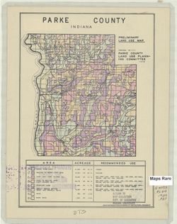
- Subject:
- Geographic Subject: Parke County (Ind.) and Topical Subject: Land use
- Creator:
- Parke County (Ind.). Land Use Planning Committee
- Publisher:
- United States. Bureau of Agricultural Economics
- Date Created:
- 1939
- Identifier:
- VAC3073-M-00689
- Genre:
- Thematic maps
- Geographic Location:
- Coordinates: W0872602 W0870034 N0395712 N0393617
- Related URL:
- Catalog URL: https://iucat.iu.edu/catalog/5126505
- Abstract:
- "Color reproduction by Bureau of Agricultural Economics, U.S.D.A." "3-30-39." Includes chart showing type of land use, acreage, and recom...
- Call Number:
- G4093.P2G4 1939 .P37
- Caption:
- Imprint: [Washington, D.C.?] : U.S. Bureau of Agricultural Economics, [1939]
- Physical Description:
- Dimensions: 17 x 16 cm, on sheet 28 x 22 cm and Scale: Scale not given.
- Alternate Identifier:
- Title Control Number: a5126505
- Persistent URL:
- https://purl.dlib.indiana.edu/iudl/images/VAC3073/VAC3073-M-00689
-
- Subject:
- Topical Subject: Maps, Geographic Subject: Priozersk, and Topical Subject: Soviet Union
- Publisher:
- Генеральный штаб Красной Армии
- Language:
- Russian
- Date Created:
- 1939
- Identifier:
- VAC9619-002552
- Genre:
- Topographic Maps and Military Maps
- Geographic Location:
- Coordinates: 61, 30, 61.333, 30.5
- Related URL:
- Download GeoTIFF: https://drive.google.com/file/d/1g54YRaxR5u9Q8rWtAobT02KApYuNbo5P/view?usp=sharing and Catalog URL: https://iucat.iu.edu/catalog/5020129
- Abstract:
- Modern area represented: Приозерск (Priozersk), Ленинградская область (Leningradskaya oblast), Russia
- Call Number:
- G7000 s100 .S7 sheet P-36-97
- Caption:
- Для служебного пользования
- City:
- Кякисальми (Kyakisalmi)
- Copyright Holder:
- No Copyright - United States
- Country:
- СССР (USSR)
- State/Province:
- Карело-Финская ССР (Karelo-Finnish Soviet Socialist Republic)
- Physical Description:
- Scale: 1:100,000
- Persistent URL:
- http://purl.dlib.indiana.edu/iudl/images/VAC9619/VAC9619-002552
- Provenance:
- DMA Topographic Center, Army Map Service Library, OMAHA
-
- Subject:
- Topical Subject: Soviet Union, Topical Subject: Maps, and Geographic Subject: Närsäkkälä
- Publisher:
- Генеральный штаб РККА
- Language:
- Russian
- Date Created:
- 1939
- Identifier:
- VAC9619-002522
- Genre:
- Military Maps and Topographic Maps
- Geographic Location:
- Coordinates: 61.667, 30, 62, 30.5
- Related URL:
- Download GeoTIFF: https://drive.google.com/file/d/1lD3wPEMHnvN5FAJGz7RJ5h9cxzYFOGvZ/view?usp=sharing and Catalog URL: https://iucat.iu.edu/catalog/5020129
- Abstract:
- Modern area represented: Närsäkkälä, Finland
- Call Number:
- G7000 s100 .S7 sheet P-36-73
- City:
- Нярсяккяля (Närsäkkälä)
- Copyright Holder:
- No Copyright - United States
- Country:
- Финляндия (Finland)
- Physical Description:
- Scale: 1:100,000
- Persistent URL:
- http://purl.dlib.indiana.edu/iudl/images/VAC9619/VAC9619-002522
- Provenance:
- DMA Topographic Center, Army Map Service Library, OMAHA
-
- Description:
- 1916
- Subject:
- Geographic Subject: Kiihtelysvaara, Topical Subject: Soviet Union, and Topical Subject: Maps
- Publisher:
- Генеральный штаб РККА
- Language:
- Russian
- Date Created:
- 1939
- Identifier:
- VAC9619-002503
- Genre:
- Topographic Maps and Military Maps
- Geographic Location:
- Coordinates: 62.333, 30, 62.667, 30.5
- Related URL:
- Catalog URL: https://iucat.iu.edu/catalog/5020129 and Download GeoTIFF: https://drive.google.com/file/d/1Sawje8wi8cQNbp_hH5onQ-X7mTXNC4Zh/view?usp=sharing
- Abstract:
- Modern area represented: Kiihtelysvaara, Finland
- Call Number:
- G7000 s100 .S7 sheet P-36-49
- Caption:
- Captured map
- City:
- Кихтелюсвара (Kiihtelysvaara)
- Copyright Holder:
- No Copyright - United States
- Country:
- Финляндия (Finland)
- Physical Description:
- Scale: 1:100,000
- Persistent URL:
- http://purl.dlib.indiana.edu/iudl/images/VAC9619/VAC9619-002503
- Provenance:
- DMA Topographic Center, Army Map Service Library, OMAHA
-
- Subject:
- Geographic Subject: Nizhniye Nikulyasy, Topical Subject: Maps, and Topical Subject: Soviet Union
- Publisher:
- Генеральный штаб РККА
- Language:
- Russian
- Date Created:
- 1939
- Identifier:
- VAC9619-002560
- Genre:
- Topographic Maps and Military Maps
- Geographic Location:
- Coordinates: 60.333, 30.5, 60.667, 31
- Related URL:
- Catalog URL: https://iucat.iu.edu/catalog/5020129 and Download GeoTIFF: https://drive.google.com/file/d/1tFqJxnQdEAeUGwwe-Yluzc0xXFpOeiA7/view?usp=sharing
- Abstract:
- Modern area represented: Nizhniye Nikulyasy, Leningrad oblast, Russia
- Call Number:
- G7000 s100 .S7 sheet P-36-122
- Caption:
- Не подлежит оглашению
- City:
- Нижние Никулясы (Nizhniye Nikulyasy)
- Copyright Holder:
- No Copyright - United States
- Country:
- СССР (USSR) and Финляндия (Finland)
- State/Province:
- РСФСР (RSFSR) and Ленинградская область (Leningrad oblast)
- Physical Description:
- Scale: 1:100,000
- Persistent URL:
- http://purl.dlib.indiana.edu/iudl/images/VAC9619/VAC9619-002560
- Provenance:
- DMA Topographic Center, Army Map Service Library, OMAHA
-

- Subject:
- Topical Subject: Maps, Topical Subject: Soviet Union, and Geographic Subject: Vaskelovo
- Publisher:
- Генеральный штаб РККА
- Language:
- Russian
- Date Created:
- 1939
- Identifier:
- VAC9619-002559
- Genre:
- Topographic Maps and Military Maps
- Geographic Location:
- Coordinates: 60.333, 30, 60.667, 30.5
- Related URL:
- Catalog URL: https://iucat.iu.edu/catalog/5020129 and Download GeoTIFF: https://drive.google.com/file/d/1KaTFvbOK3MkKRTdccoRAWA7PKsR_VX2V/view?usp=sharing
- Abstract:
- Modern area represented: Vaskelovo, Leningrad oblast, Russia
- Call Number:
- G7000 s100 .S7 sheet P-36-121
- Caption:
- Не подлежит оглашению
- City:
- Васкелово (Vaskelovo)
- Copyright Holder:
- No Copyright - United States
- Country:
- СССР (USSR) and Финляндия (Finland)
- State/Province:
- Ленинградская область (Leningrad oblast) and РСФСР (RSFSR)
- Physical Description:
- Scale: 1:100,000
- Persistent URL:
- http://purl.dlib.indiana.edu/iudl/images/VAC9619/VAC9619-002559
- Provenance:
- DMA Topographic Center, Army Map Service Library, OMAHA
-
- Description:
- 1895
- Subject:
- Topical Subject: Soviet Union, Geographic Subject: Ostrov Konevets, and Topical Subject: Maps
- Publisher:
- Генеральный штаб РККА
- Language:
- Russian
- Date Created:
- 1939
- Identifier:
- VAC9619-002558
- Genre:
- Military Maps and Topographic Maps
- Geographic Location:
- Coordinates: 60.667, 30.5, 61, 31
- Related URL:
- Download GeoTIFF: https://drive.google.com/file/d/1taYkxOC0qRl-z6qvkPvR1CIcJ4VbgPoI/view?usp=sharing and Catalog URL: https://iucat.iu.edu/catalog/5020129
- Abstract:
- Modern area represented: остров Коневец (Ostrov Konevets), Ленинградская область (Leningradskaya oblast), Russia
- Call Number:
- G7000 s100 .S7 sheet P-36-110
- City:
- О. Коневиц (Ostrov Konevits)
- Copyright Holder:
- No Copyright - United States
- Country:
- Финляндия (Finland)
- Physical Description:
- Scale: 1:100,000
- Persistent URL:
- http://purl.dlib.indiana.edu/iudl/images/VAC9619/VAC9619-002558
- Provenance:
- DMA Topographic Center, Army Map Service Library, OMAHA
-
- Subject:
- Geographic Subject: Hollola, Topical Subject: Maps, and Topical Subject: Soviet Union
- Publisher:
- Генеральный штаб РККА
- Language:
- Russian
- Date Created:
- 1939
- Identifier:
- VAC9619-002378
- Genre:
- Military Maps and Topographic Maps
- Geographic Location:
- Coordinates: 61, 25, 61.333, 25.5
- Related URL:
- Download GeoTIFF: https://drive.google.com/file/d/1G9-o_sxDwmqdEJa5oEOu1EmBfCGEWTqy/view?usp=sharing and Catalog URL: https://iucat.iu.edu/catalog/5020129
- Abstract:
- Modern area represented: Hollola, Finland
- Call Number:
- G7000 s100 .S7 sheet P-35-99
- City:
- Холлола (Hollola)
- Copyright Holder:
- No Copyright - United States
- Country:
- Финляндия (Finland)
- Physical Description:
- Scale: 1:100,000
- Persistent URL:
- http://purl.dlib.indiana.edu/iudl/images/VAC9619/VAC9619-002378
- Provenance:
- DMA Topographic Center, Army Map Service Library, OMAHA
-
- Description:
- 1916
- Subject:
- Geographic Subject: Elisenvaara, Topical Subject: Maps, and Topical Subject: Soviet Union
- Publisher:
- Генеральный штаб РККА
- Language:
- Russian
- Date Created:
- 1939
- Identifier:
- VAC9619-002376
- Genre:
- Topographic Maps and Military Maps
- Geographic Location:
- Coordinates: 61.333, 29.5, 61.667, 30
- Related URL:
- Download GeoTIFF: https://drive.google.com/file/d/1r__05RId3G4G7IXpLA_zD-h6qObbPKRs/view?usp=sharing and Catalog URL: https://iucat.iu.edu/catalog/5020129
- Abstract:
- Modern area represented: Elisenvaara, Republic of Karelia, Russia (from 1940).
- Call Number:
- G7000 s100 .S7 sheet P-35-96
- City:
- Элисенвара (Elisenvaara)
- Copyright Holder:
- No Copyright - United States
- Country:
- Финляндия (Finland)
- Physical Description:
- Scale: 1:100,000
- Persistent URL:
- http://purl.dlib.indiana.edu/iudl/images/VAC9619/VAC9619-002376
- Provenance:
- DMA Topographic Center, Army Map Service Library, OMAHA
-
- Description:
- 1916
- Subject:
- Topical Subject: Soviet Union, Topical Subject: Maps, and Geographic Subject: Mäntylahti
- Publisher:
- Генеральный штаб РККА
- Language:
- Russian
- Date Created:
- 1939
- Identifier:
- VAC9619-002375
- Genre:
- Military Maps and Topographic Maps
- Geographic Location:
- Coordinates: 61.333, 29, 61.667, 29.5
- Related URL:
- Download GeoTIFF: https://drive.google.com/file/d/1q_qZyXRKch1I9MJMbGaaU9dWBZGZsmy_/view?usp=sharing and Catalog URL: https://iucat.iu.edu/catalog/5020129
- Abstract:
- Modern area represented: Mäntylahti, Finland
- Call Number:
- G7000 s100 .S7 sheet P-35-95
- Caption:
- Captured map
- City:
- Мянтюлахти (Mäntylahti )
- Copyright Holder:
- No Copyright - United States
- Country:
- Финляндия (Finland)
- Physical Description:
- Scale: 1:100,000
- Persistent URL:
- http://purl.dlib.indiana.edu/iudl/images/VAC9619/VAC9619-002375
- Provenance:
- DMA Topographic Center, Army Map Service Library, OMAHA, Auswärtiges Amt. Geographischer Dienst
-
- Subject:
- Topical Subject: Soviet Union, Geographic Subject: Virmutjoki, and Topical Subject: Maps
- Publisher:
- Генеральный штаб РККА
- Language:
- Russian
- Date Created:
- 1939
- Identifier:
- VAC9619-002374
- Genre:
- Military Maps and Topographic Maps
- Geographic Location:
- Coordinates: 61.333, 28.5, 61.667, 29
- Related URL:
- Download GeoTIFF: https://drive.google.com/file/d/1QdExuBIOzuCPRRmLDVSwZ-3IRDZZ4U5w/view?usp=sharing and Catalog URL: https://iucat.iu.edu/catalog/5020129
- Abstract:
- Modern area represented: Virmutjoki, Finland
- Call Number:
- G7000 s100 .S7 sheet P-35-94
- Caption:
- Captured map
- City:
- Вирмутйоки (Virmutjoki)
- Copyright Holder:
- No Copyright - United States
- Country:
- Финляндия (Finland)
- Physical Description:
- Scale: 1:100,000
- Persistent URL:
- http://purl.dlib.indiana.edu/iudl/images/VAC9619/VAC9619-002374
- Provenance:
- DMA Topographic Center, Army Map Service Library, OMAHA
-
- Description:
- 1916
- Subject:
- Topical Subject: Maps, Topical Subject: Soviet Union, and Geographic Subject: Puumala
- Publisher:
- Генеральный штаб РККА
- Language:
- Russian
- Date Created:
- 1939
- Identifier:
- VAC9619-002373
- Genre:
- Military Maps and Topographic Maps
- Geographic Location:
- Coordinates: 61.333, 28, 61.667, 28.5
- Related URL:
- Download GeoTIFF: https://drive.google.com/file/d/1a5346KwCl0xCAjDDaBRgKZ1ET_dedkle/view?usp=sharing and Catalog URL: https://iucat.iu.edu/catalog/5020129
- Abstract:
- Modern area represented: Puumala, Finland
- Call Number:
- G7000 s100 .S7 sheet P-35-93
- Caption:
- Временное издание,Captured map
- City:
- Пумала (Puumala)
- Copyright Holder:
- No Copyright - United States
- Country:
- Финляндия (Finland)
- Physical Description:
- Scale: 1:100,000
- Persistent URL:
- http://purl.dlib.indiana.edu/iudl/images/VAC9619/VAC9619-002373
- Provenance:
- DMA Topographic Center, Army Map Service Library, OMAHA
-
- Description:
- 1912
- Subject:
- Geographic Subject: Kangasala, Topical Subject: Maps, and Topical Subject: Soviet Union
- Publisher:
- Генеральный штаб РККА
- Language:
- Russian
- Date Created:
- 1939
- Identifier:
- VAC9619-002370
- Genre:
- Military Maps and Topographic Maps
- Geographic Location:
- Coordinates: 61.333, 24, 61.667, 24.5
- Related URL:
- Download GeoTIFF: https://drive.google.com/file/d/1IFgPi9bxzVbfdHJ4VeFK6g1WlNMHQyik/view?usp=sharing and Catalog URL: https://iucat.iu.edu/catalog/5020129
- Abstract:
- Modern area represented: Kangasala, Finland
- Call Number:
- G7000 s100 .S7 sheet P-35-85
- Caption:
- Captured map
- City:
- Кангасала (Kangasala)
- Copyright Holder:
- No Copyright - United States
- Country:
- Финляндия (Finland)
- Physical Description:
- Scale: 1:100,000
- Persistent URL:
- http://purl.dlib.indiana.edu/iudl/images/VAC9619/VAC9619-002370
- Provenance:
- DMA Topographic Center, Army Map Service Library, OMAHA
-
- Description:
- 1916
- Subject:
- Topical Subject: Soviet Union, Topical Subject: Maps, and Geographic Subject: Kesälahti
- Publisher:
- Генеральный штаб РККА
- Language:
- Russian
- Date Created:
- 1939
- Identifier:
- VAC9619-002369
- Genre:
- Military Maps and Topographic Maps
- Geographic Location:
- Coordinates: 61.667, 29.5, 62, 30
- Related URL:
- Catalog URL: https://iucat.iu.edu/catalog/5020129 and Download GeoTIFF: https://drive.google.com/file/d/1hCJjeCW7MGy9JPgBGY_DUczayW09nt_5/view?usp=sharing
- Abstract:
- Modern area represented: Kesälahti, Finland
- Call Number:
- G7000 s100 .S7 sheet P-35-84
- City:
- Кесялахти (Kesälahti)
- Copyright Holder:
- No Copyright - United States
- Country:
- Финляндия (Finland)
- Physical Description:
- Scale: 1:100,000
- Persistent URL:
- http://purl.dlib.indiana.edu/iudl/images/VAC9619/VAC9619-002369
- Provenance:
- DMA Topographic Center, Army Map Service Library, OMAHA
-
- Description:
- 1916
- Subject:
- Geographic Subject: Kerimäki, Topical Subject: Soviet Union, and Topical Subject: Maps
- Publisher:
- Генеральный штаб РККА
- Language:
- Russian
- Date Created:
- 1939
- Identifier:
- VAC9619-002368
- Genre:
- Military Maps and Topographic Maps
- Geographic Location:
- Coordinates: 61.667, 29, 62, 29.5
- Related URL:
- Download GeoTIFF: https://drive.google.com/file/d/1Lv-tQ5wu0HLaTpj1s5h9L7CeyUIpiVaD/view?usp=sharing and Catalog URL: https://iucat.iu.edu/catalog/5020129
- Abstract:
- Modern area represented: Kerimäki, Finland
- Call Number:
- G7000 s100 .S7 sheet P-35-83
- Caption:
- Captured map
- City:
- Керимяки (Kerimäki)
- Copyright Holder:
- No Copyright - United States
- Country:
- Финляндия (Finland)
- Physical Description:
- Scale: 1:100,000
- Persistent URL:
- http://purl.dlib.indiana.edu/iudl/images/VAC9619/VAC9619-002368
- Provenance:
- DMA Topographic Center, Army Map Service Library, OMAHA, Auswärtiges Amt. Geographischer Dienst
-
- Description:
- 1916
- Subject:
- Topical Subject: Maps, Topical Subject: Soviet Union, and Geographic Subject: Savonlinna
- Publisher:
- Генеральный штаб РККА
- Language:
- Russian
- Date Created:
- 1939
- Identifier:
- VAC9619-002367
- Genre:
- Military Maps and Topographic Maps
- Geographic Location:
- Coordinates: 61.667, 28.5, 62, 29
- Related URL:
- Catalog URL: https://iucat.iu.edu/catalog/5020129 and Download GeoTIFF: https://drive.google.com/file/d/13F5bSAX_IhEDWD6bLBBavGFMxn7u_ZFn/view?usp=sharing
- Abstract:
- Modern area represented: Savonlinna, Finland
- Call Number:
- G7000 s100 .S7 sheet P-35-82
- City:
- Савонлинна (Savonlinna)
- Copyright Holder:
- No Copyright - United States
- Country:
- Финляндия (Finland)
- Physical Description:
- Scale: 1:100,000
- Persistent URL:
- http://purl.dlib.indiana.edu/iudl/images/VAC9619/VAC9619-002367
- Provenance:
- DMA Topographic Center, Army Map Service Library, OMAHA
-
- Description:
- 1916
- Subject:
- Geographic Subject: Sulkava, Topical Subject: Maps, and Topical Subject: Soviet Union
- Publisher:
- Генеральный штаб РККА
- Language:
- Russian
- Date Created:
- 1939
- Identifier:
- VAC9619-002366
- Genre:
- Topographic Maps and Military Maps
- Geographic Location:
- Coordinates: 61.667, 28, 62, 28.5
- Related URL:
- Catalog URL: https://iucat.iu.edu/catalog/5020129 and Download GeoTIFF: https://drive.google.com/file/d/1FI2gzWCdnuzZA0BtpJ-Sz-NJtZodFLr9/view?usp=sharing
- Abstract:
- Modern area represented: Sulkava, Finland
- Call Number:
- G7000 s100 .S7 sheet P-35-81
- Caption:
- Временное издание,Captured map
- City:
- Сулкава (Sulkava)
- Copyright Holder:
- No Copyright - United States
- Country:
- Финляндия (Finland)
- Physical Description:
- Scale: 1:100,000
- Persistent URL:
- http://purl.dlib.indiana.edu/iudl/images/VAC9619/VAC9619-002366
- Provenance:
- DMA Topographic Center, Army Map Service Library, OMAHA
-
- Description:
- 1916
- Subject:
- Topical Subject: Maps, Geographic Subject: Juva, and Topical Subject: Soviet Union
- Publisher:
- Генеральный штаб РККА
- Language:
- Russian
- Date Created:
- 1939
- Identifier:
- VAC9619-002365
- Genre:
- Topographic Maps and Military Maps
- Geographic Location:
- Coordinates: 61.667, 27.5, 62, 28
- Related URL:
- Download GeoTIFF: https://drive.google.com/file/d/1e9q2fOI0gXpYKI-E7mFET-bX_OV5fj6c/view?usp=sharing and Catalog URL: https://iucat.iu.edu/catalog/5020129
- Abstract:
- Modern area represented: Juva, Finland
- Call Number:
- G7000 s100 .S7 sheet P-35-80
- City:
- Юва (Juva)
- Copyright Holder:
- No Copyright - United States
- Country:
- Финляндия (Finland)
- Physical Description:
- Scale: 1:100,000
- Persistent URL:
- http://purl.dlib.indiana.edu/iudl/images/VAC9619/VAC9619-002365
- Provenance:
- DMA Topographic Center, Army Map Service Library, OMAHA
-
- Description:
- 1916
- Subject:
- Topical Subject: Soviet Union, Geographic Subject: Rääkkylä, and Topical Subject: Maps
- Publisher:
- Генеральный штаб РККА
- Language:
- Russian
- Date Created:
- 1939
- Identifier:
- VAC9619-002364
- Genre:
- Topographic Maps and Military Maps
- Geographic Location:
- Coordinates: 62, 29.5, 62.3333, 30
- Related URL:
- Download GeoTIFF: https://drive.google.com/file/d/14V6lh3163laFY-ySuND-Vmmc500xckfX/view?usp=sharing and Catalog URL: https://iucat.iu.edu/catalog/5020129
- Abstract:
- Modern area represented: Rääkkylä, Finland
- Call Number:
- G7000 s100 .S7 sheet P-35-72
- City:
- Ряккюля (Rääkkylä)
- Copyright Holder:
- No Copyright - United States
- Country:
- Финляндия (Finland)
- Physical Description:
- Scale: 1:100,000
- Persistent URL:
- http://purl.dlib.indiana.edu/iudl/images/VAC9619/VAC9619-002364
- Provenance:
- DMA Topographic Center, Army Map Service Library, OMAHA
-
- Subject:
- Geographic Subject: Savonranta, Topical Subject: Maps, and Topical Subject: Soviet Union
- Publisher:
- Генеральный штаб РККА
- Language:
- Russian
- Date Created:
- 1939
- Identifier:
- VAC9619-002363
- Genre:
- Topographic Maps and Military Maps
- Geographic Location:
- Coordinates: 62, 29, 62.3333, 29.5
- Related URL:
- Catalog URL: https://iucat.iu.edu/catalog/5020129 and Download GeoTIFF: https://drive.google.com/file/d/17Lm2hHYSWu-w-W6nxyiPKbHRx-5-RqNB/view?usp=sharing
- Abstract:
- Modern area represented: Savonranta, Finland
- Call Number:
- G7000 s100 .S7 sheet P-35-71
- Caption:
- Временное издание
- City:
- Савонранта (Savonranta)
- Copyright Holder:
- No Copyright - United States
- Country:
- Финляндия (Finland)
- Physical Description:
- Scale: 1:100,000
- Persistent URL:
- http://purl.dlib.indiana.edu/iudl/images/VAC9619/VAC9619-002363
- Provenance:
- DMA Topographic Center, Army Map Service Library, OMAHA
-
- Description:
- 1916
- Subject:
- Topical Subject: Soviet Union, Geographic Subject: Joensuu, and Topical Subject: Maps
- Publisher:
- Генеральный штаб РККА
- Language:
- Russian
- Date Created:
- 1939
- Identifier:
- VAC9619-002317
- Genre:
- Military Maps and Topographic Maps
- Geographic Location:
- Coordinates: 62.3333, 29.5, 62.6667, 30
- Related URL:
- Download GeoTIFF: https://drive.google.com/file/d/1uP_pzBhc6QMROXL-IYnKJ5i9KEs-UYJG/view?usp=sharing and Catalog URL: https://iucat.iu.edu/catalog/5020129
- Abstract:
- Modern area represented: Joensuu, Finland
- Call Number:
- G7000 s100 .S7 sheet P-35-60
- City:
- Йоэнсу (Joensuu)
- Copyright Holder:
- No Copyright - United States
- Country:
- Финляндия (Finland)
- Physical Description:
- Scale: 1:100,000
- Persistent URL:
- http://purl.dlib.indiana.edu/iudl/images/VAC9619/VAC9619-002317
- Provenance:
- DMA Topographic Center, Army Map Service Library, OMAHA
-
- Description:
- 1916
- Subject:
- Geographic Subject: Kontiolahti, Topical Subject: Maps, and Topical Subject: Soviet Union
- Publisher:
- Генеральный штаб РККА
- Language:
- Russian
- Date Created:
- 1939
- Identifier:
- VAC9619-002316
- Genre:
- Military Maps and Topographic Maps
- Geographic Location:
- Coordinates: 62.6667, 29.5, 63, 30
- Related URL:
- Catalog URL: https://iucat.iu.edu/catalog/5020129 and Download GeoTIFF: https://drive.google.com/file/d/14fyIgZM99qlL1Z5-fbRRUfhycZ23QG6b/view?usp=sharing
- Abstract:
- Modern area represented: Kontiolahti, Finland
- Call Number:
- G7000 s100 .S7 sheet P-35-48
- City:
- Контиолахти (Kontiolahti)
- Copyright Holder:
- No Copyright - United States
- Country:
- Финляндия (Finland)
- Physical Description:
- Scale: 1:100,000
- Persistent URL:
- http://purl.dlib.indiana.edu/iudl/images/VAC9619/VAC9619-002316
- Provenance:
- DMA Topographic Center, Army Map Service Library, OMAHA
-
- Subject:
- Topical Subject: Soviet Union, Topical Subject: Maps, and Geographic Subject: Sestroretsk
- Publisher:
- Генеральный штаб РККА
- Language:
- Russian
- Date Created:
- 1939
- Identifier:
- VAC9619-002418
- Genre:
- Topographic Maps and Military Maps
- Geographic Location:
- Coordinates: 60, 29.5, 60.333, 30
- Related URL:
- Download GeoTIFF: https://drive.google.com/file/d/1xYwqhjaPZRREgkXrpchvcgAOfuVfxPNk/view?usp=sharing and Catalog URL: https://iucat.iu.edu/catalog/5020129
- Abstract:
- Modern area represented: Sestroretsk, Russia
- Call Number:
- G7000 s100 .S7 sheet P-35-144
- Caption:
- Не подлежит оглашению,Captured map
- City:
- Сестрорецк (Sestroretsk)
- Copyright Holder:
- No Copyright - United States
- Country:
- Финляндия (Finland) and СССР (USSR)
- State/Province:
- РСФСР (RSFSR) and Ленинградская область (Leningrad oblast)
- Physical Description:
- Scale: 1:100,000
- Persistent URL:
- http://purl.dlib.indiana.edu/iudl/images/VAC9619/VAC9619-002418
- Provenance:
- DMA Topographic Center, Army Map Service Library, OMAHA
-
- Subject:
- Geographic Subject: Polyany, Topical Subject: Soviet Union, and Topical Subject: Maps
- Publisher:
- Генеральный штаб РККА
- Language:
- Russian
- Date Created:
- 1939
- Identifier:
- VAC9619-002417
- Genre:
- Topographic Maps and Military Maps
- Geographic Location:
- Coordinates: 60, 29, 60.333, 29.5
- Related URL:
- Catalog URL: https://iucat.iu.edu/catalog/5020129 and Download GeoTIFF: https://drive.google.com/file/d/1hnaoZA09Ml3qEq3-fN5nULSXfvFAaVhk/view?usp=sharing
- Abstract:
- Modern area represented: Поляны (Polyany), Leningradskaya oblast, Russia
- Call Number:
- G7000 s100 .S7 sheet P-35-143
- Caption:
- Captured map
- City:
- Усикиркко (Uusikirkko)
- Copyright Holder:
- No Copyright - United States
- Physical Description:
- Scale: 1:100,000
- Persistent URL:
- http://purl.dlib.indiana.edu/iudl/images/VAC9619/VAC9619-002417
- Provenance:
- DMA Topographic Center, Army Map Service Library, Auswärtiges Amt. Geographischer Dienst
-
- Subject:
- Topical Subject: Soviet Union, Topical Subject: Maps, and Geographic Subject: Krasnoostrovskiy
- Publisher:
- Генеральный штаб РККА
- Language:
- Russian
- Date Created:
- 1939
- Identifier:
- VAC9619-002416
- Genre:
- Military Maps and Topographic Maps
- Geographic Location:
- Coordinates: 60, 28.5, 60.333, 29
- Related URL:
- Download GeoTIFF: https://drive.google.com/file/d/1BZ4cCb4BI9yHKnw4AhipKu_bSbjBEq1Q/view?usp=sharing and Catalog URL: https://iucat.iu.edu/catalog/5020129
- Abstract:
- Modern area represented: Красноостровский (Krasnoostrovskiy), Leningradskaya oblast, Russia
- Call Number:
- G7000 s100 .S7 sheet P-35-142
- Caption:
- Captured map
- City:
- Саренпяя (Saarenpää)
- Copyright Holder:
- No Copyright - United States
- Country:
- СССР (USSR) and Финляндия (Finland)
- Physical Description:
- Scale: 1:100,000
- Persistent URL:
- http://purl.dlib.indiana.edu/iudl/images/VAC9619/VAC9619-002416
- Provenance:
- DMA Topographic Center, Army Map Service Library
-
- Subject:
- Geographic Subject: Korpo, Topical Subject: Maps, and Topical Subject: Soviet Union
- Publisher:
- Генеральный штаб Красной Армии
- Language:
- Russian
- Date Created:
- 1939
- Identifier:
- VAC9619-002311
- Genre:
- Military Maps and Topographic Maps
- Geographic Location:
- Coordinates: 60, 21.5, 60.3333, 22
- Related URL:
- Catalog URL: https://iucat.iu.edu/catalog/5020129 and Download GeoTIFF: https://drive.google.com/file/d/1qglpg0vy7tjkA4Gg9i6GOuIzY0jaXqtI/view?usp=sharing
- Abstract:
- Modern area represented: Korpo, Finland
- Call Number:
- G7000 s100 .S7 sheet P-34-140
- City:
- Корпо (Korpo)
- Copyright Holder:
- No Copyright - United States
- Country:
- Финляндия (Finland)
- Physical Description:
- Scale: 1:100,000
- Persistent URL:
- http://purl.dlib.indiana.edu/iudl/images/VAC9619/VAC9619-002311
- Provenance:
- DMA Topographic Center, Army Map Service Library, OMAHA
-
- Description:
- 1875
- Subject:
- Topical Subject: Maps, Topical Subject: Soviet Union, and Geographic Subject: Gogland
- Publisher:
- Генеральный штаб РККА
- Language:
- Russian
- Date Created:
- 1939
- Identifier:
- VAC9619-002414
- Genre:
- Military Maps and Topographic Maps
- Geographic Location:
- Coordinates: 60, 26.5, 60.333, 27
- Related URL:
- Catalog URL: https://iucat.iu.edu/catalog/5020129 and Download GeoTIFF: https://drive.google.com/file/d/1TBIFiwbq9DcAyjliFXqHzOjghhlpjUy9/view?usp=sharing
- Abstract:
- Modern area represented: Гогланд (Gogland), Leningradskaya oblast, Russia
- Call Number:
- G7000 s100 .S7 sheet P-35-138
- Caption:
- Captured map
- City:
- О. Сур-Сари (Suursaari)
- Copyright Holder:
- No Copyright - United States
- Country:
- Финляндия (Finland)
- Physical Description:
- Scale: 1:100,000
- Persistent URL:
- http://purl.dlib.indiana.edu/iudl/images/VAC9619/VAC9619-002414
- Provenance:
- DMA Topographic Center, Army Map Service Library, OMAHA
-
- Subject:
- Topical Subject: Soviet Union, Geographic Subject: Tapanila, and Topical Subject: Maps
- Publisher:
- Генеральный штаб Красной Армии
- Language:
- Russian
- Date Created:
- 1939
- Identifier:
- VAC9619-002412
- Genre:
- Military Maps and Topographic Maps
- Geographic Location:
- Coordinates: 60, 25, 60.333, 25.5
- Related URL:
- Catalog URL: https://iucat.iu.edu/catalog/5020129 and Download GeoTIFF: https://drive.google.com/file/d/1iFASd5MYfRFOfLEYYGOm3N-IZUmVhjFw/view?usp=sharing
- Abstract:
- Modern area represented: Tapanila, Finland
- Call Number:
- G7000 s100 .S7 sheet P-35-135
- Caption:
- Captured map
- City:
- Тапанила (Tapanila)
- Copyright Holder:
- No Copyright - United States
- Country:
- Финляндия (Finland)
- Physical Description:
- Scale: 1:100,000
- Persistent URL:
- http://purl.dlib.indiana.edu/iudl/images/VAC9619/VAC9619-002412
- Provenance:
- DMA Topographic Center, Army Map Service Library
-
- Description:
- 1886
- Subject:
- Topical Subject: Soviet Union, Topical Subject: Maps, and Geographic Subject: Kondrat'yevo
- Publisher:
- Генеральный штаб РККА
- Language:
- Russian
- Date Created:
- 1939
- Identifier:
- VAC9619-002406
- Genre:
- Military Maps and Topographic Maps
- Geographic Location:
- Coordinates: 60.333, 28, 60.667, 28.5
- Related URL:
- Download GeoTIFF: https://drive.google.com/file/d/1t4DoY0L3dAZIEbkp-RFGtY2mj5LgEKVc/view?usp=sharing and Catalog URL: https://iucat.iu.edu/catalog/5020129
- Abstract:
- Modern area represented: Кондратьево (Kondrat'yevo), Leningradskaya oblast, Russia
- Call Number:
- G7000 s100 .S7 sheet P-35-129
- City:
- Сяккиярви (Säkkijärvi)
- Copyright Holder:
- No Copyright - United States
- Country:
- Финляндия (Finland)
- Physical Description:
- Scale: 1:100,000
- Persistent URL:
- http://purl.dlib.indiana.edu/iudl/images/VAC9619/VAC9619-002406
- Provenance:
- DMA Topographic Center, Army Map Service Library, OMAHA
-
- Subject:
- Topical Subject: Soviet Union, Topical Subject: Maps, and Geographic Subject: Hamina
- Publisher:
- Генеральный штаб Красной Армии
- Language:
- Russian
- Date Created:
- 1939
- Identifier:
- VAC9619-002404
- Genre:
- Military Maps and Topographic Maps
- Geographic Location:
- Coordinates: 60.333, 27, 60.667, 27.5
- Related URL:
- Catalog URL: https://iucat.iu.edu/catalog/5020129 and Download GeoTIFF: https://drive.google.com/file/d/1fqgwkumlDwELE37ecAjWjDH5LhaBfUxR/view?usp=sharing
- Abstract:
- Modern area represented: Hamina, Finland
- Call Number:
- G7000 s100 .S7 sheet P-35-127
- Caption:
- Captured map
- City:
- Хамина (Hamina)
- Copyright Holder:
- No Copyright - United States
- Country:
- Финляндия (Finland)
- Physical Description:
- Scale: 1:100,000
- Persistent URL:
- http://purl.dlib.indiana.edu/iudl/images/VAC9619/VAC9619-002404
- Provenance:
- DMA Topographic Center, Army Map Service Library, OMAHA
-
- Description:
- 1875
- Subject:
- Topical Subject: Soviet Union, Geographic Subject: Kotka, and Topical Subject: Maps
- Publisher:
- Генеральный штаб Красной Армии
- Language:
- Russian
- Date Created:
- 1939
- Identifier:
- VAC9619-002403
- Genre:
- Military Maps and Topographic Maps
- Geographic Location:
- Coordinates: 60.333, 26.5, 60.667, 27
- Related URL:
- Download GeoTIFF: https://drive.google.com/file/d/1Fyb5bGv10GXdei7v5enJpjJOqxrVt_On/view?usp=sharing and Catalog URL: https://iucat.iu.edu/catalog/5020129
- Abstract:
- Modern area represented: Kotka, Finland
- Call Number:
- G7000 s100 .S7 sheet P-35-126
- Caption:
- Captured map
- City:
- Котка (Kotka)
- Copyright Holder:
- No Copyright - United States
- Country:
- Финляндия (Finland)
- Physical Description:
- Scale: 1:100,000
- Persistent URL:
- http://purl.dlib.indiana.edu/iudl/images/VAC9619/VAC9619-002403
- Provenance:
- DMA Topographic Center, Army Map Service Library, OMAHA
-
- Subject:
- Geographic Subject: Mel'nikovo, Topical Subject: Maps, and Topical Subject: Soviet Union
- Publisher:
- Генеральный штаб РККА
- Language:
- Russian
- Date Created:
- 1939
- Identifier:
- VAC9619-002397
- Genre:
- Topographic Maps and Military Maps
- Geographic Location:
- Coordinates: 60.667, 29.5, 61, 30
- Related URL:
- Download GeoTIFF: https://drive.google.com/file/d/1cH4B7-OjHw1cZRzbWauwJ0Ts19OSB0Df/view?usp=sharing and Catalog URL: https://iucat.iu.edu/catalog/5020129
- Abstract:
- Modern area represented: Мельниково (Mel'nikovo), Leningradskaya oblast, Russia
- Call Number:
- G7000 s100 .S7 sheet P-35-120
- Caption:
- Captured map
- City:
- Ряйсяля (Räisälä)
- Copyright Holder:
- No Copyright - United States
- Country:
- Финляндия (Finland)
- Physical Description:
- Scale: 1:100,000
- Persistent URL:
- http://purl.dlib.indiana.edu/iudl/images/VAC9619/VAC9619-002397
- Provenance:
- DMA Topographic Center, Army Map Service Library, OMAHA
-
- Subject:
- Topical Subject: Maps, Topical Subject: Soviet Union, and Geographic Subject: Taavetti
- Publisher:
- Генеральный штаб Красной Армии
- Language:
- Russian
- Date Created:
- 1939
- Identifier:
- VAC9619-002393
- Genre:
- Topographic Maps and Military Maps
- Geographic Location:
- Coordinates: 60.667, 27.5, 61, 28
- Related URL:
- Download GeoTIFF: https://drive.google.com/file/d/1_0upZn5x4nK-RQt0-kITOgFkmUngJ5EF/view?usp=sharing and Catalog URL: https://iucat.iu.edu/catalog/5020129
- Abstract:
- Modern area represented: Taavetti, Finland
- Call Number:
- G7000 s100 .S7 sheet P-35-116
- City:
- Таветти (Taavetti)
- Copyright Holder:
- No Copyright - United States
- Country:
- СССР (USSR) and Финляндия (Finland)
- State/Province:
- Карело-Финская ССР (Karelo-Finnish Soviet Socialist Republic)
- Physical Description:
- Scale: 1:100,000
- Persistent URL:
- http://purl.dlib.indiana.edu/iudl/images/VAC9619/VAC9619-002393
- Provenance:
- DMA Topographic Center, Army Map Service Library, OMAHA, Auswärtiges Amt. Geographischer Dienst
-
- Subject:
- Topical Subject: Soviet Union, Geographic Subject: Khiitola, and Topical Subject: Maps
- Publisher:
- Генеральный штаб Красной Армии
- Language:
- Russian
- Date Created:
- 1939
- Identifier:
- VAC9619-002385
- Genre:
- Military Maps and Topographic Maps
- Geographic Location:
- Coordinates: 61, 29.5, 61.333, 30
- Related URL:
- Catalog URL: https://iucat.iu.edu/catalog/5020129 and Download GeoTIFF: https://drive.google.com/file/d/1fkqGc7IU1YSGuwtz1GR0chBKK35hTOgY/view?usp=sharing
- Abstract:
- Modern area represented: Khiitola, Republic of Karelia, Russia
- Call Number:
- G7000 s100 .S7 sheet P-35-108
- Caption:
- Для служебного пользования
- City:
- Хитола (Khiitola)
- Copyright Holder:
- No Copyright - United States
- Country:
- СССР (USSR)
- State/Province:
- Карело-Финская ССР (Karelo-Finnish Soviet Socialist Republic)
- Physical Description:
- Scale: 1:100,000
- Persistent URL:
- http://purl.dlib.indiana.edu/iudl/images/VAC9619/VAC9619-002385
- Provenance:
- DMA Topographic Center, Army Map Service Library, Auswärtiges Amt. Geographischer Dienst, University of Kansas Map Library
-
- Subject:
- Geographic Subject: Imatra, Topical Subject: Maps, and Topical Subject: Soviet Union
- Publisher:
- Генеральный штаб РККА
- Language:
- Russian
- Date Created:
- 1939
- Identifier:
- VAC9619-002383
- Genre:
- Topographic Maps and Military Maps
- Geographic Location:
- Coordinates: 61.0, 28.5, 61.3333, 29.0
- Related URL:
- Download GeoTIFF: https://drive.google.com/file/d/1w404K4UK3V6MELAGxJ5LiyQgrzw_5-hi/view?usp=sharing and Catalog URL: https://iucat.iu.edu/catalog/5020129
- Abstract:
- Modern area represented: Imatra, Finland
- Call Number:
- G7000 s100 .S7 sheet P-35-106
- City:
- Иматра (Imatra)
- Copyright Holder:
- No Copyright - United States
- Country:
- Финляндия (Finland)
- Physical Description:
- Scale: 1:100,000
- Persistent URL:
- http://purl.dlib.indiana.edu/iudl/images/VAC9619/VAC9619-002383
- Provenance:
- DMA Topographic Center, Army Map Service Library, OMAHA, Auswärtiges Amt. Geographischer Dienst
-
- Subject:
- Geographic Subject: Lappeenranta, Topical Subject: Maps, and Topical Subject: Soviet Union
- Publisher:
- Генеральный штаб РККА
- Language:
- Russian
- Date Created:
- 1939
- Identifier:
- VAC9619-002382
- Genre:
- Military Maps and Topographic Maps
- Geographic Location:
- Coordinates: 61.0, 28.0, 61.3333, 28.5
- Related URL:
- Catalog URL: https://iucat.iu.edu/catalog/5020129 and Download GeoTIFF: https://drive.google.com/file/d/1UNTfqZkx_hXTpmM7SF0AXaQAj-FTEkAl/view?usp=sharing
- Abstract:
- Modern area represented: Lappeenranta, Finland
- Call Number:
- G7000 s100 .S7 sheet P-35-105
- Caption:
- Captured map
- City:
- Лаппенранта (Lappeenranta)
- Copyright Holder:
- No Copyright - United States
- Country:
- Финляндия (Finland)
- Physical Description:
- Scale: 1:100,000
- Persistent URL:
- http://purl.dlib.indiana.edu/iudl/images/VAC9619/VAC9619-002382
- Provenance:
- DMA Topographic Center, Army Map Service Library, OMAHA
-
- Description:
- 1892
- Subject:
- Geographic Subject: Savitaipale, Topical Subject: Maps, and Topical Subject: Soviet Union
- Publisher:
- Генеральный штаб РККА
- Language:
- Russian
- Date Created:
- 1939
- Identifier:
- VAC9619-002381
- Genre:
- Military Maps and Topographic Maps
- Geographic Location:
- Coordinates: 61.0, 27.5, 61.33333, 28.0
- Related URL:
- Catalog URL: https://iucat.iu.edu/catalog/5020129 and Download GeoTIFF: https://drive.google.com/file/d/1t1TkT2Pf30O8AHwoc8UTvqEsgHwO5Qmk/view?usp=sharing
- Abstract:
- Modern area represented: Savitaipale, Finland
- Call Number:
- G7000 s100 .S7 sheet P-35-104
- City:
- Савитайпале (Savitaipale)
- Copyright Holder:
- No Copyright - United States
- Country:
- Финляндия (Finland)
- Physical Description:
- Scale: 1:100,000
- Persistent URL:
- http://purl.dlib.indiana.edu/iudl/images/VAC9619/VAC9619-002381
- Provenance:
- DMA Topographic Center, Army Map Service Library, OMAHA
-
- Description:
- 1885
- Subject:
- Topical Subject: Soviet Union, Topical Subject: Maps, and Geographic Subject: Suomenniemi
- Publisher:
- Генеральный штаб РККА
- Language:
- Russian
- Date Created:
- 1939
- Identifier:
- VAC9619-002380
- Genre:
- Topographic Maps and Military Maps
- Geographic Location:
- Coordinates: 61.0, 27.0, 61.3333, 27.5
- Related URL:
- Download GeoTIFF: https://drive.google.com/file/d/1dr84EVfC4H5PcZvkPguwFf7wz02QZChe/view?usp=sharing and Catalog URL: https://iucat.iu.edu/catalog/5020129
- Abstract:
- Modern area represented: Suomenniemi, Finland
- Call Number:
- G7000 s100 .S7 sheet P-35-103
- Caption:
- Captured map
- City:
- Суоменниеми (Suomenniemi)
- Copyright Holder:
- No Copyright - United States
- Country:
- Финляндия (Finland)
- Physical Description:
- Scale: 1:100,000
- Persistent URL:
- http://purl.dlib.indiana.edu/iudl/images/VAC9619/VAC9619-002380
- Provenance:
- DMA Topographic Center, Army Map Service Library, OMAHA
-
- Subject:
- Topical Subject: Maps, Topical Subject: Soviet Union, and Geographic Subject: Karis
- Publisher:
- Генеральный штаб Красной Армии
- Language:
- Russian
- Date Created:
- 1939
- Identifier:
- VAC9619-002315
- Genre:
- Military Maps and Topographic Maps
- Geographic Location:
- Coordinates: 60, 23.5, 60.3333, 24
- Related URL:
- Catalog URL: https://iucat.iu.edu/catalog/5020129 and Download GeoTIFF: https://drive.google.com/file/d/1Bdcrsrz3RiC5WHXFMUNHXLAo0wqPayGC/view?usp=sharing
- Abstract:
- Modern area represented: Karis, Finland
- Call Number:
- G7000 s100 .S7 sheet P-34-144
- City:
- Карис (Karis)
- Copyright Holder:
- No Copyright - United States
- Country:
- Финляндия (Finland)
- Physical Description:
- Scale: 1:100,000
- Persistent URL:
- http://purl.dlib.indiana.edu/iudl/images/VAC9619/VAC9619-002315
- Provenance:
- DMA Topographic Center, Army Map Service Library, OMAHA
-
- Subject:
- Topical Subject: Soviet Union, Geographic Subject: Tenala, and Topical Subject: Maps
- Publisher:
- Генеральный штаб Красной Армии
- Language:
- Russian
- Date Created:
- 1939
- Identifier:
- VAC9619-002314
- Genre:
- Topographic Maps and Military Maps
- Geographic Location:
- Coordinates: 60, 23, 60.3333, 23.5
- Related URL:
- Catalog URL: https://iucat.iu.edu/catalog/5020129 and Download GeoTIFF: https://drive.google.com/file/d/1T-iu25sezIn-TSKcPj8GAbyP2ayZYGci/view?usp=sharing
- Abstract:
- Modern area represented: Tenala, Finland
- Call Number:
- G7000 s100 .S7 sheet P-34-143
- City:
- Тенала (Tenala)
- Copyright Holder:
- No Copyright - United States
- Country:
- Финляндия (Finland)
- Physical Description:
- Scale: 1:100,000
- Persistent URL:
- http://purl.dlib.indiana.edu/iudl/images/VAC9619/VAC9619-002314
- Provenance:
- DMA Topographic Center, Army Map Service Library, OMAHA
-
- Subject:
- Topical Subject: Soviet Union, Geographic Subject: Kimito, and Topical Subject: Maps
- Publisher:
- Генеральный штаб Красной Армии
- Language:
- Russian
- Date Created:
- 1939
- Identifier:
- VAC9619-002313
- Genre:
- Military Maps and Topographic Maps
- Geographic Location:
- Coordinates: 60, 22.5, 60.3333, 23
- Related URL:
- Download GeoTIFF: https://drive.google.com/file/d/1Uv6Av5VydaEEAn4UVugqUtJ023dNTT4r/view?usp=sharing and Catalog URL: https://iucat.iu.edu/catalog/5020129
- Abstract:
- Modern area represented: Kimito, Finland
- Call Number:
- G7000 s100 .S7 sheet P-34-142
- City:
- Кимито (Kimito)
- Copyright Holder:
- No Copyright - United States
- Country:
- Финляндия (Finland)
- Physical Description:
- Scale: 1:100,000
- Persistent URL:
- http://purl.dlib.indiana.edu/iudl/images/VAC9619/VAC9619-002313
- Provenance:
- DMA Topographic Center, Army Map Service Library, OMAHA
-
- Subject:
- Topical Subject: Soviet Union, Topical Subject: Maps, and Geographic Subject: Pargas
- Publisher:
- Генеральный штаб Красной Армии
- Language:
- Russian
- Date Created:
- 1939
- Identifier:
- VAC9619-002312
- Genre:
- Topographic Maps and Military Maps
- Geographic Location:
- Coordinates: 60, 22, 60.3333, 22.5
- Related URL:
- Download GeoTIFF: https://drive.google.com/file/d/1cbAAFHDUoctpFo3dmO3AnoH9quQf5Qzi/view?usp=sharing and Catalog URL: https://iucat.iu.edu/catalog/5020129
- Abstract:
- Modern area represented: Pargas, Finland
- Call Number:
- G7000 s100 .S7 sheet P-34-141
- City:
- Паргас (Pargas)
- Copyright Holder:
- No Copyright - United States
- Country:
- Финляндия (Finland)
- Physical Description:
- Scale: 1:100,000
- Persistent URL:
- http://purl.dlib.indiana.edu/iudl/images/VAC9619/VAC9619-002312
- Provenance:
- DMA Topographic Center, Army Map Service Library, OMAHA
