
Search Constraints
You searched for:
Campus
IUB
Remove constraint Campus: IUB
Holding Location
B-WELLS
Remove constraint Holding Location: B-WELLS
Type
Image
Remove constraint Type: Image
Pages
0-99 pages
Remove constraint Pages: 0-99 pages
« Previous |
1 - 100 of 8,218
|
Next »
Search Results
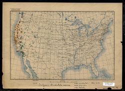
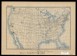
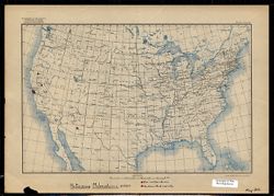
-
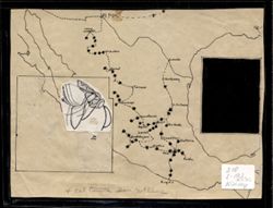
- Subject:
- Entomologists and Wasps
- Creator:
- Kinsey, Alfred C. (Alfred Charles), 1894-1956
- Language:
- English
- Date Created:
- Circa 1931-1932
- Identifier:
- VAE1595-000004
- Geographic Location:
- Mexico and United States
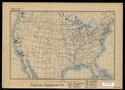
- Abstract:
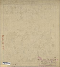
- Map created by Alfred C. Kinsey displaying route and data points associated with Kinsey's field research on gall wasps. On this map, data points, marked ...
- Call Number:
- 210 L-193 (1931-32) Kinsey
- Caption:
- The words "4 col tonite Don McClane" appear at the bottom center of the map. It is unclear at this time whether the words are related to the map co...
- Country:
- United States
- Persistent URL:
- http://purl.dlib.indiana.edu/iudl/images/VAE1595/VAE1595-000004
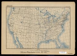
-
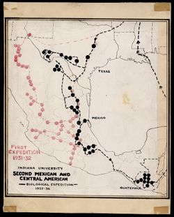
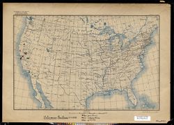
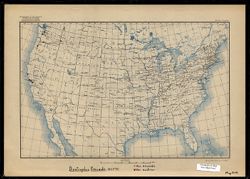
- Subject:
- Wasps and Entomologists
- Creator:
- Kinsey, Alfred C. (Alfred Charles), 1894-1956
- Language:
- English
- Date Created:
- Circa 1936-1937
- Identifier:
- VAE1595-000003
- Geographic Location:
- United States, Mexico, and Guatemala
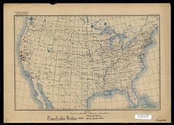
- Abstract:
- Map created by Alfred C. Kinsey displaying routes and data points associated with Kinsey's field research on gall wasps. On this map, Second Expedition d...
- Country:
- United States
- Persistent URL:
- http://purl.dlib.indiana.edu/iudl/images/VAE1595/VAE1595-000003
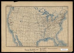
-
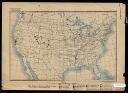
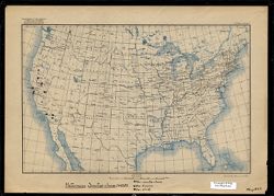
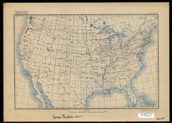
- Subject:
- Entomologists and Wasps
- Creator:
- Kinsey, Alfred C. (Alfred Charles), 1894-1956
- Language:
- Latin and English
- Date Created:
- Circa 1917-1937
- Identifier:
- VAE1595-000006
- Geographic Location:
- United States and Canada
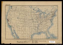
- Abstract:
- One of a series of maps created or annotated by Alfred C. Kinsey, Most contain gall wasp data. Several only contain data on other types of flora and fauna. O...
- Caption:
- Var. tuberculatrix, Var. similis, Var. arefacta, Var. multispinosa, Var. coloradensis, Var. subcoloradesis [sic], Var. tumida, Var. xerophila, Var. wasatchen...
- Country:
- United States
- Physical Description:
- Base map type 1 (USGS. Edition of May 1906, reprinted 1922.) Map scale indicated in both graphic representation and representative fraction., Print Size: 7.5...
- Alternate Identifier:
- Map B28
- Persistent URL:
- http://purl.dlib.indiana.edu/iudl/images/VAE1595/VAE1595-000006
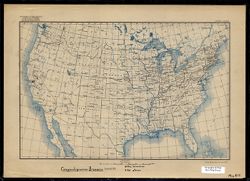
-
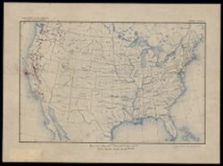
- Subject:
- Trees and Entomologists
- Creator:
- Kinsey, Alfred C. (Alfred Charles), 1894-1956
- Language:
- English
- Date Created:
- Circa 1917-1937
- Identifier:
- VAE1595-000005
- Geographic Location:
- Canada, United States, and Mexico
- Abstract:
- One of a series of maps created or annotated by Alfred C. Kinsey. Most contain gall wasp data. Several only contain data on other types of flora and fauna. T...
- Country:
- United States
- Physical Description:
- Print Size: 7.5 x 11.5, Base map type 2 (USGS. Edition of Mar. 1911, reprinted 1923). Map scale indicated in graphic representation only., and Scale: Approxi...
- Persistent URL:
- http://purl.dlib.indiana.edu/iudl/images/VAE1595/VAE1595-000005
-
- Subject:
- Reptiles and Entomologists
- Creator:
- Kinsey, Alfred C. (Alfred Charles), 1894-1956
- Language:
- English and Latin
- Date Created:
- Circa 1917-1937
- Identifier:
- VAE1595-000008
- Geographic Location:
- United States and Mexico
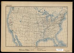
- Abstract:
- One of a series of maps created or annotated by Alfred C. Kinsey. Most contain gall wasp data. Several only contain data on other types of flora and fauna. O...
- Caption:
- Var. occidentalis, Var. biseriatus, Var. taylori, Var. Beckii. This map is torn in several places on the bottom edge. One tear obscures the end of a handwrit...
- Country:
- United States
- Physical Description:
- Base map type 1 (USGS. Edition of May 1906, reprinted 1922.) Map scale indicated in both graphic representation and representative fraction., Scale: 1:11,875...
- Alternate Identifier:
- Map D2
- Persistent URL:
- http://purl.dlib.indiana.edu/iudl/images/VAE1595/VAE1595-000008
-
![Pituophis Catenife[r] Blainville](https://iiif.uits.iu.edu/iiif/2/7w62gm576%2Ffiles%2F173c48ee-315d-4457-a1b8-f492d0eedbb1/full/250,/0/default.jpg)
- Subject:
- Snakes and Entomologists
- Creator:
- Kinsey, Alfred C. (Alfred Charles), 1894-1956
- Language:
- Latin and English
- Date Created:
- 1917-1937
- Identifier:
- VAE1595-000007
- Geographic Location:
- United States and Mexico
- Abstract:
- One of a series of maps created or annotated by Alfred C. Kinsey. Most contain gall wasp data. Several only contain data on other types of flora and fauna. O...
- Caption:
- catenifer, heermanni, annectens, stejnegeri, deserticola, rutilus, ?? determination uncertain, possibly deserticola.
- Country:
- United States
- Physical Description:
- Scale: 1:11,875,000, Print Size: 7.5 x 11.5, and Base map type 1 (USGS. Edition of May 1906, reprinted 1922.) Map scale indicated in both graphic representat...
- Alternate Identifier:
- Map D1
- Persistent URL:
- http://purl.dlib.indiana.edu/iudl/images/VAE1595/VAE1595-000007
-
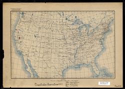
- Subject:
- Entomologists and Wasps
- Creator:
- Kinsey, Alfred C. (Alfred Charles), 1894-1956
- Language:
- English and Latin
- Date Created:
- Circa 1917-1937
- Identifier:
- VAE1595-000009
- Geographic Location:
- United States
- Abstract:
- One of a series of maps created or annotated by Alfred C. Kinsey. Most contain gall wasp data. Several only contain data on other types of flora and fauna. O...
- Caption:
- Var. pacificus, Var. subpacificus, Var. gracilis
- Country:
- United States
- Physical Description:
- Base map type 1 (USGS. Edition of May 1906, reprinted 1922.) Map scale indicated in both graphic representation and representative fraction., Print Size: 7.5...
- Alternate Identifier:
- Map B22
- Persistent URL:
- http://purl.dlib.indiana.edu/iudl/images/VAE1595/VAE1595-000009
-
- Subject:
- Entomologists and Wasps
- Creator:
- Kinsey, Alfred C. (Alfred Charles), 1894-1956
- Language:
- Latin and English
- Date Created:
- Circa 1917-1937
- Identifier:
- VAE1595-000010
- Geographic Location:
- United States
- Abstract:
- One of a series of maps created or annotated by Alfred C. Kinsey. Most contain gall wasp data. Several only contain data on other types of flora and fauna. O...
- Caption:
- Var. sanctae-clarae, Var. fuscior, Var. aliud
- Country:
- United States
- Physical Description:
- Scale: 1:11,875,000, Base map type 1 (USGS. Edition of May 1906, reprinted 1922.) Map scale indicated in both graphic representation and representative fract...
- Alternate Identifier:
- Map B23
- Persistent URL:
- http://purl.dlib.indiana.edu/iudl/images/VAE1595/VAE1595-000010
-
- Subject:
- Wasps and Entomologists
- Creator:
- Kinsey, Alfred C. (Alfred Charles), 1894-1956
- Language:
- Latin and English
- Date Created:
- Circa 1917-1937
- Identifier:
- VAE1595-000011
- Geographic Location:
- United States
- Abstract:
- One of a series of maps created or annotated by Alfred C. Kinsey. Most contain gall wasp data. Several only contain data on other types of flora and fauna. O...
- Caption:
- Var. asymmetricus, Var. annectens, Var. compactus
- Country:
- United States
- Physical Description:
- Print Size: 7.5 x 11.5, Base map type 1 (USGS. Edition of May 1906, reprinted 1922.) Map scale indicated in both graphic representation and representative fr...
- Alternate Identifier:
- Map B24
- Persistent URL:
- http://purl.dlib.indiana.edu/iudl/images/VAE1595/VAE1595-000011
-
- Subject:
- Entomologists and Wasps
- Creator:
- Kinsey, Alfred C. (Alfred Charles), 1894-1956
- Language:
- English and Latin
- Date Created:
- Circa 1917-1937
- Identifier:
- VAE1595-000012
- Geographic Location:
- United States
- Abstract:
- One of a series of maps created or annotated by Alfred C. Kinsey. Most contain gall wasp data. Several only contain data on other types of flora and fauna. O...
- Caption:
- Var. chrysolepidicola, Var. kelloggi, Var. diminuens, Var. alutaceus, Var. compositus, Var atricinctus, Var. pugnus, Var. pugnoides, Var. garryanae
- Country:
- United States
- Physical Description:
- Print Size: 7.5 x 11.5, Scale: 1:11,875,000, and Base map type 1 (USGS. Edition of May 1906, reprinted 1922.) Map scale indicated in both graphic representat...
- Alternate Identifier:
- Map B25
- Persistent URL:
- http://purl.dlib.indiana.edu/iudl/images/VAE1595/VAE1595-000012
-
- Subject:
- Entomologists and Wasps
- Creator:
- Kinsey, Alfred C. (Alfred Charles), 1894-1956
- Language:
- English and Latin
- Date Created:
- Circa 1917-1937
- Identifier:
- VAE1595-000013
- Geographic Location:
- United States
- Abstract:
- One of a series of maps created or annotated by Alfred C. Kinsey. Most contain gall wasp data. Several only contain data on other types of flora and fauna. O...
- Caption:
- Var. perdens, Var. destructor
- Country:
- United States
- Physical Description:
- Print Size: 7.5 x 11.5, Base map type 1 (USGS. Edition of May 1906, reprinted 1922.) Map scale indicated in both graphic representation and representative fr...
- Alternate Identifier:
- Map B26
- Persistent URL:
- http://purl.dlib.indiana.edu/iudl/images/VAE1595/VAE1595-000013
-
- Subject:
- Wasps and Entomologists
- Creator:
- Kinsey, Alfred C. (Alfred Charles), 1894-1956
- Language:
- English and Latin
- Date Created:
- Circa 1917-1937
- Identifier:
- VAE1595-000014
- Geographic Location:
- United States
- Abstract:
- One of a series of maps created or annotated by Alfred C. Kinsey. Most contain gall wasp data. Several only contain data on other types of flora and fauna. O...
- Caption:
- Var. suttonii, Var. polythyra, Var. lustrior, undescribed variety
- Country:
- United States
- Physical Description:
- Base map type 1 (USGS. Edition of May 1906, reprinted 1922.) Map scale indicated in both graphic representation and representative fraction., Print Size: 7.5...
- Alternate Identifier:
- Map B27
- Persistent URL:
- http://purl.dlib.indiana.edu/iudl/images/VAE1595/VAE1595-000014
-
- Subject:
- Wasps and Entomologists
- Creator:
- Kinsey, Alfred C. (Alfred Charles), 1894-1956
- Language:
- English and Latin
- Date Created:
- Circa 1917-1937
- Identifier:
- VAE1595-000015
- Geographic Location:
- United States
- Abstract:
- One of a series of maps created or annotated by Alfred C. Kinsey. Most contain gall wasp data. Several only contain data on other types of flora and fauna. O...
- Caption:
- Var. bakeri, Variety undescribed
- Country:
- United States
- Physical Description:
- Base map type 1 (USGS. Edition of May 1906, reprinted 1922.) Map scale indicated in both graphic representation and representative fraction., Scale: 1:11,875...
- Alternate Identifier:
- Map B18
- Persistent URL:
- http://purl.dlib.indiana.edu/iudl/images/VAE1595/VAE1595-000015
-
- Subject:
- Entomologists and Wasps
- Creator:
- Kinsey, Alfred C. (Alfred Charles), 1894-1956
- Language:
- English and Latin
- Date Created:
- Circa 1917-1937
- Identifier:
- VAE1595-000016
- Geographic Location:
- United States
- Abstract:
- One of a series of maps created or annotated by Alfred C. Kinsey. Most contain gall wasp data. Several only contain data on other types of flora and fauna. O...
- Caption:
- Var. dasydaclyli [sic], Var. eriophorus, Var. pygmaeus, Var. medius
- Country:
- United States
- Physical Description:
- Scale: 1:11,875,000, Print Size: 7.5 x 11.5, and Base map type 1 (USGS. Edition of May 1906, reprinted 1922.) Map scale indicated in both graphic representat...
- Alternate Identifier:
- Map B19
- Persistent URL:
- http://purl.dlib.indiana.edu/iudl/images/VAE1595/VAE1595-000016
-
- Subject:
- Wasps and Entomologists
- Creator:
- Kinsey, Alfred C. (Alfred Charles), 1894-1956
- Language:
- English and Latin
- Date Created:
- Circa 1917-1937
- Identifier:
- VAE1595-000017
- Geographic Location:
- United States
- Abstract:
- One of a series of maps created or annotated by Alfred C. Kinsey. Most contain gall wasp data. Several only contain data on other types of flora and fauna. O...
- Caption:
- Var. chrysolepidis, Var. malus
- Country:
- United States
- Physical Description:
- Base map type 1 (USGS. Edition of May 1906, reprinted 1922.) Map scale indicated in both graphic representation and representative fraction., Print Size: 7.5...
- Alternate Identifier:
- Map B20
- Persistent URL:
- http://purl.dlib.indiana.edu/iudl/images/VAE1595/VAE1595-000017
-
- Subject:
- Entomologists and Wasps
- Creator:
- Kinsey, Alfred C. (Alfred Charles), 1894-1956
- Language:
- English and Latin
- Date Created:
- Circa 1917-1937
- Identifier:
- VAE1595-000019
- Geographic Location:
- United States
- Abstract:
- One of a series of maps created or annotated by Alfred C. Kinsey. Most contain gall wasp data. Several only contain data on other types of flora and fauna. O...
- Caption:
- Var. spectabilis, Var. incisus, Var. ukiahensis, Variety has not been determined.
- Country:
- United States
- Physical Description:
- Scale: 1:11,875,000, Print Size: 7.5 x 11.5, and Base map type 1 (USGS. Edition of May 1906, reprinted 1922.) Map scale indicated in both graphic representat...
- Alternate Identifier:
- Map B11
- Persistent URL:
- http://purl.dlib.indiana.edu/iudl/images/VAE1595/VAE1595-000019
-
- Subject:
- Entomologists and Wasps
- Creator:
- Kinsey, Alfred C. (Alfred Charles), 1894-1956
- Language:
- English and Latin
- Date Created:
- Circa 1917-1937
- Identifier:
- VAE1595-000020
- Geographic Location:
- United States
- Abstract:
- One of a series of maps created or annotated by Alfred C. Kinsey. Most contain gall wasp data. Several only contain data on other types of flora and fauna. O...
- Caption:
- Var. brunneus, Var. atrior
- Country:
- United States
- Physical Description:
- Base map type 1 (USGS. Edition of May 1906, reprinted 1922.) Map scale indicated in both graphic representation and representative fraction., Print Size: 7.5...
- Alternate Identifier:
- Map B12
- Persistent URL:
- http://purl.dlib.indiana.edu/iudl/images/VAE1595/VAE1595-000020
-
- Subject:
- Entomologists and Wasps
- Creator:
- Kinsey, Alfred C. (Alfred Charles), 1894-1956
- Language:
- Latin and English
- Date Created:
- Circa 1917-1937
- Identifier:
- VAE1595-000018
- Geographic Location:
- United States
- Abstract:
- One of a series of maps created or annotated by Alfred C. Kinsey. Most contain gall wasp data. Several only contain data on other types of flora and fauna. O...
- Caption:
- Var. melanoderma, Undescribed variety
- Country:
- United States
- Physical Description:
- Print Size: 7.5 x 11.5, Base map type 1 (USGS. Edition of May 1906, reprinted 1922.) Map scale indicated in both graphic representation and representative fr...
- Alternate Identifier:
- Map B21
- Persistent URL:
- http://purl.dlib.indiana.edu/iudl/images/VAE1595/VAE1595-000018
-
- Subject:
- Wasps and Entomologists
- Creator:
- Kinsey, Alfred C. (Alfred Charles), 1894-1956
- Language:
- English and Latin
- Date Created:
- Circa 1917-1937
- Identifier:
- VAE1595-000022
- Geographic Location:
- United States
- Abstract:
- One of a series of maps created or annotated by Alfred C. Kinsey. Most contain gall wasp data. Several only contain data on other types of flora and fauna. O...
- Caption:
- Var. kincaidii, Var. austrior
- Country:
- United States
- Physical Description:
- Print Size: 7.5 x 11.5, Scale: 1:11,875,000, and Base map type 1 (USGS. Edition of May 1906, reprinted 1922.) Map scale indicated in both graphic representat...
- Alternate Identifier:
- Map B14
- Persistent URL:
- http://purl.dlib.indiana.edu/iudl/images/VAE1595/VAE1595-000022
-
- Subject:
- Entomologists and Wasps
- Creator:
- Kinsey, Alfred C. (Alfred Charles), 1894-1956
- Language:
- Latin and English
- Date Created:
- Circa 1917-1937
- Identifier:
- VAE1595-000021
- Geographic Location:
- United States
- Abstract:
- One of a series of maps created or annotated by Alfred C. Kinsey. Most contain gall wasp data. Several only contain data on other types of flora and fauna. O...
- Country:
- United States
- Physical Description:
- Scale: 1:11,875,000, Print Size: 7.5 x 11.5, and Base map type 1 (USGS. Edition of May 1906, reprinted 1922.) Map scale indicated in both graphic representat...
- Alternate Identifier:
- Map B13
- Persistent URL:
- http://purl.dlib.indiana.edu/iudl/images/VAE1595/VAE1595-000021
-
- Description:
- 1938
- Subject:
- Topical Subject: Soviet Union, Topical Subject: Maps, and Geographic Subject: Gorshkovo
- Publisher:
- Главное Управление Геодезии и Картографии при СНК СССР
- Language:
- Russian
- Date Created:
- 1941
- Identifier:
- VAC9619-001600
- Genre:
- Military Maps and Topographic Maps
- Geographic Location:
- Coordinates: 54.3333, 37.75, 54.5, 38
- Related URL:
- DataCORE Dataset Download: https://datacore.iu.edu/concern/data_sets/b8515p00j
- Abstract:
- Modern area represented: Gorshkovo, Tula oblast, Russia
- Call Number:
- G7000 s50 .S68 sheet N-37-52-Г
- City:
- Горшково (Gorshkovo)
- Copyright Holder:
- No Copyright - United States
- Country:
- СССР (USSR)
- State/Province:
- РСФСР (RSFSR) and Тульская область (Tula oblast)
- Physical Description:
- Scale: 1:50,000
- Persistent URL:
- http://purl.dlib.indiana.edu/iudl/images/VAC9619/VAC9619-001600
- Provenance:
- DMA Topographic Center, Army Map Service Library, OMAHA, Library of Congress Geography & Map Division
-
- Description:
- 1853
- Subject:
- Geographic Subject: Laptevo, Topical Subject: Soviet Union, and Topical Subject: Maps
- Publisher:
- Управление военных топографов
- Language:
- Russian
- Date Created:
- 1930
- Identifier:
- VAC9619-001599
- Genre:
- Topographic Maps and Military Maps
- Geographic Location:
- Coordinates: 54.333, 37.573, 54.5, 37.823
- Related URL:
- DataCORE Dataset Download: https://datacore.iu.edu/concern/data_sets/sx61dn22f
- Abstract:
- Modern area represented: Laptevo, Tula oblast, Russia
- Call Number:
- G7000 s50 .S68 sheet N-37-52-В/Г
- City:
- Ст. Лаптево (Laptevo)
- Copyright Holder:
- No Copyright - United States
- Country:
- СССР (USSR)
- State/Province:
- Московская область (Moscow oblast) and РСФСР (RSFSR)
- Physical Description:
- Scale: 1:50,000
- Persistent URL:
- http://purl.dlib.indiana.edu/iudl/images/VAC9619/VAC9619-001599
- Provenance:
- Army Map Service Library, Library of Congress Geography & Map Division, OMAHA
-
- Description:
- 1938
- Subject:
- Topical Subject: Maps, Geographic Subject: Laptevo, and Topical Subject: Soviet Union
- Publisher:
- Главное Управление Геодезии и Картографии при СНК СССР
- Language:
- Russian
- Date Created:
- 1941
- Identifier:
- VAC9619-001598
- Genre:
- Military Maps and Topographic Maps
- Geographic Location:
- Coordinates: 54.3333, 37.5, 54.5, 37.75
- Related URL:
- DataCORE Dataset Download: https://datacore.iu.edu/concern/data_sets/q811kk327
- Abstract:
- Moder area represented: Laptevo, Tula oblast, Russia
- Call Number:
- G7000 s50 .S68 sheet N-37-52-B
- City:
- Лаптево (Laptevo)
- Copyright Holder:
- No Copyright - United States
- Country:
- СССР (USSR)
- State/Province:
- Тульская область (Tula oblast) and РСФСР (RSFSR)
- Physical Description:
- Scale: 1:50,000
- Persistent URL:
- http://purl.dlib.indiana.edu/iudl/images/VAC9619/VAC9619-001598
- Provenance:
- DMA Topographic Center, Army Map Service Library, OMAHA, Library of Congress Geography & Map Division
-
- Description:
- 1938
- Subject:
- Topical Subject: Maps, Geographic Subject: Mokraya Kor, and Topical Subject: Soviet Union
- Publisher:
- Главное Управление Геодезии и Картографии при СНК СССР
- Language:
- Russian
- Date Created:
- 1941
- Identifier:
- VAC9619-001597
- Genre:
- Military Maps and Topographic Maps
- Geographic Location:
- Coordinates: 54.5, 37.75, 54.6667, 38
- Related URL:
- DataCORE Dataset Download: https://datacore.iu.edu/concern/data_sets/4f16c344j
- Abstract:
- Modern area represented: Mokraya Kor, Tula oblast, Russia
- Call Number:
- G7000 s50 .S68 sheet N-37-52-B
- City:
- Мокрая Корь (Mokraya Kor)
- Copyright Holder:
- No Copyright - United States
- Country:
- СССР (USSR)
- State/Province:
- Тульская область (Tula oblast) and РСФСР (RSFSR)
- Physical Description:
- Scale: 1:50,000
- Persistent URL:
- http://purl.dlib.indiana.edu/iudl/images/VAC9619/VAC9619-001597
- Provenance:
- DMA Topographic Center, Army Map Service Library, OMAHA, Library of Congress Geography & Map Division
-
- Description:
- 1938
- Subject:
- Geographic Subject: Nikiforovo, Topical Subject: Maps, and Topical Subject: Soviet Union
- Publisher:
- Главное Управление Геодезии и Картографии при СНК СССР
- Language:
- Russian
- Date Created:
- 1941
- Identifier:
- VAC9619-001596
- Genre:
- Topographic Maps and Military Maps
- Geographic Location:
- Coordinates: 54.833, 37.5, 55, 37.75
- Related URL:
- DataCORE Dataset Download: https://datacore.iu.edu/concern/data_sets/mc87pq98b
- Abstract:
- Modern area represented: Nikiforovo, Moscow oblast, Russia
- Call Number:
- G7000 s50 .S68 sheet N-37-40-A
- City:
- Никифорово (Nikiforovo)
- Copyright Holder:
- No Copyright - United States
- Country:
- СССР (USSR)
- State/Province:
- РСФСР (RSFSR), Московская область (Moscow oblast), and Тульская область (Tula oblast)
- Physical Description:
- Scale: 1:50,000
- Persistent URL:
- http://purl.dlib.indiana.edu/iudl/images/VAC9619/VAC9619-001596
- Provenance:
- DMA Topographic Center, Army Map Service Library, OMAHA, Library of Congress Geography & Map Division
-
- Description:
- 1939
- Subject:
- Topical Subject: Soviet Union, Geographic Subject: Novoye Titovo, and Topical Subject: Maps
- Publisher:
- Главное Управление Геодезии и Картографии при СНК СССР
- Language:
- Russian
- Date Created:
- 1941
- Identifier:
- VAC9619-001595
- Genre:
- Topographic Maps and Military Maps
- Geographic Location:
- Coordinates: 55.5, 39, 55.6667, 39.25
- Related URL:
- DataCORE Dataset Download: https://datacore.iu.edu/concern/data_sets/tt44pn64c
- Abstract:
- Modern area represented: Novoye Titovo, Moscow oblast, Russia
- Call Number:
- G7000 s50 .S68 sheet N-37-19-A
- Copyright Holder:
- No Copyright - United States
- Country:
- СССР (USSR)
- State/Province:
- Московская область (Moscow oblast) and РСФСР (RSFSR)
- Physical Description:
- Scale: 1:50,000
- Persistent URL:
- http://purl.dlib.indiana.edu/iudl/images/VAC9619/VAC9619-001595
- Provenance:
- Army Map Service Library, Library of Congress Geography & Map Division, OMAHA
-
- Description:
- 1926
- Subject:
- Topical Subject: Maps, Geographic Subject: Ilyinsky Pogost, and Topical Subject: Soviet Union
- Publisher:
- Главный Геодезический Комитет
- Language:
- Russian
- Identifier:
- VAC9619-001594
- Genre:
- Military Maps and Topographic Maps
- Geographic Location:
- Coordinates: 55.3333, 38.75, 55.5, 39
- Related URL:
- DataCORE Dataset Download: https://datacore.iu.edu/concern/data_sets/4b29b6716
- Abstract:
- Modern area represented: Ilyinsky Pogost, Moscow oblast, Russia
- Call Number:
- G7000 s50 .S68 sheet N-37-18-Г
- City:
- Ильинский Погост (Ilinskiy Pogost)
- Copyright Holder:
- No Copyright - United States
- Country:
- СССР (USSR)
- State/Province:
- РСФСР (RSFSR) and Московская область (Moscow oblast)
- Physical Description:
- Scale: 1:50,000
- Persistent URL:
- http://purl.dlib.indiana.edu/iudl/images/VAC9619/VAC9619-001594
- Provenance:
- Army Map Service Library, Library of Congress Geography & Map Division, OMAHA
-
- Description:
- 1927
- Subject:
- Geographic Subject: Kurovskoye, Topical Subject: Soviet Union, and Topical Subject: Maps
- Publisher:
- Главный Геодезический Комитет
- Language:
- Russian
- Identifier:
- VAC9619-001592
- Genre:
- Topographic Maps and Military Maps
- Geographic Location:
- Coordinates: 55.5, 38.75, 55.6667, 39
- Related URL:
- DataCORE Dataset Download: https://datacore.iu.edu/concern/data_sets/b2773w576
- Abstract:
- Modern area represented: Kurovskoye, Moscow oblast, Russia
- Call Number:
- G7000 s50 .S68 sheet N-37-18-Б
- City:
- Куровская (Kurovskaya)
- Copyright Holder:
- No Copyright - United States
- Country:
- СССР (USSR)
- State/Province:
- Московская область (Moscow oblast) and РСФСР (RSFSR)
- Physical Description:
- Scale: 1:50,000
- Persistent URL:
- http://purl.dlib.indiana.edu/iudl/images/VAC9619/VAC9619-001592
- Provenance:
- DMA Topographic Center, Army Map Service Library, OMAHA, Library of Congress Geography & Map Division
-
- Description:
- 1926
- Subject:
- Topical Subject: Soviet Union, Topical Subject: Maps, and Geographic Subject: Konobeyevo
- Publisher:
- Главный Геодезический Комитет
- Language:
- Russian
- Identifier:
- VAC9619-001593
- Genre:
- Topographic Maps and Military Maps
- Geographic Location:
- Coordinates: 55.3333, 38.5, 55.5, 38.75
- Related URL:
- DataCORE Dataset Download: https://datacore.iu.edu/concern/data_sets/dn39x218s
- Abstract:
- Modern area represented: Konobeyevo, Moscow oblast, Russia
- Call Number:
- G7000 s50 .S68 sheet N-37-18-B
- City:
- Конобеево (Konobeyevo)
- Copyright Holder:
- No Copyright - United States
- Country:
- СССР (USSR)
- State/Province:
- Московская область (Moscow oblast) and РСФСР (RSFSR)
- Physical Description:
- Scale: 1:50,000
- Persistent URL:
- http://purl.dlib.indiana.edu/iudl/images/VAC9619/VAC9619-001593
- Provenance:
- DMA Topographic Center, Army Map Service Library, Library of Congress Geography & Map Division
-
- Description:
- 1883
- Subject:
- Geographic Subject: Târgu Ocna, Topical Subject: Soviet Union, and Topical Subject: Maps
- Publisher:
- Генеральный штаб РККА
- Language:
- Russian
- Date Created:
- 1901
- Identifier:
- VAC9619-001591
- Genre:
- Topographic Maps and Military Maps
- Geographic Location:
- Coordinates: 46, 26.5, 46.3333, 27
- Related URL:
- DataCORE Dataset Download: https://datacore.iu.edu/concern/data_sets/pc289j823
- Abstract:
- Modern area represented: Târgu Ocna, Bacău county, Romania
- Call Number:
- G7000 s100 .S7 sheet L-35-66
- City:
- Тыргул Окна (Târgu Ocna)
- Copyright Holder:
- No Copyright - United States
- Country:
- Румыния (Romania)
- Physical Description:
- Scale: 1:100,000
- Persistent URL:
- http://purl.dlib.indiana.edu/iudl/images/VAC9619/VAC9619-001591
- Provenance:
- CIA Map Library, Atlasblatt
-
- Description:
- 1938
- Subject:
- Geographic Subject: Vereya, Topical Subject: Soviet Union, and Topical Subject: Maps
- Publisher:
- Главное Управление Геодезии и Картографии при СНК СССР
- Language:
- Russian
- Date Created:
- 1941
- Identifier:
- VAC9619-001590
- Genre:
- Topographic Maps and Military Maps
- Geographic Location:
- Coordinates: 55.3333, 36, 55.5, 36.25
- Related URL:
- DataCORE Dataset Download: https://datacore.iu.edu/concern/data_sets/cc08hg43h
- Abstract:
- Modern area represented: Vereya, Moscow oblast, Russia
- Call Number:
- G7000 s50 .S68 sheet N-37-13-C
- Copyright Holder:
- No Copyright - United States
- Country:
- СССР (USSR)
- State/Province:
- РСФСР (RSFSR) and Московская область (Moscow oblast)
- Physical Description:
- Scale: 1:50,000
- Persistent URL:
- http://purl.dlib.indiana.edu/iudl/images/VAC9619/VAC9619-001590
- Provenance:
- DMA Topographic Center, Army Map Service Library, OMAHA, Library of Congress Geography & Map Division
-
- Description:
- 1938
- Subject:
- Topical Subject: Maps, Topical Subject: Soviet Union, and Geographic Subject: Dorokhovo
- Publisher:
- Главное Управление Геодезии и Картографии при СНК СССР
- Language:
- Russian
- Date Created:
- 1941
- Identifier:
- VAC9619-001589
- Genre:
- Topographic Maps and Military Maps
- Geographic Location:
- Coordinates: 55.5, 36.25, 55.6667, 36.5
- Related URL:
- DataCORE Dataset Download: https://datacore.iu.edu/concern/data_sets/zw12z608d
- Abstract:
- Modern area represented: Dorokhovo, Moscow oblast, Russia
- Call Number:
- G7000 s50 .S68 sheet N-37-13-Б
- City:
- Дорохово (Dorokhovo)
- Copyright Holder:
- No Copyright - United States
- Country:
- СССР (USSR)
- State/Province:
- РСФСР (RSFSR) and Московская область (Moscow oblast)
- Physical Description:
- Scale: 1:50,000
- Persistent URL:
- http://purl.dlib.indiana.edu/iudl/images/VAC9619/VAC9619-001589
- Provenance:
- DMA Topographic Center, Army Map Service Library, OMAHA, Library of Congress Geography & Map Division
-
- Description:
- 1938
- Subject:
- Geographic Subject: Mozhaysk, Topical Subject: Soviet Union, and Topical Subject: Maps
- Publisher:
- Главное Управление Геодезии и Картографии при СНК СССР
- Language:
- Russian
- Date Created:
- 1941
- Identifier:
- VAC9619-001588
- Genre:
- Topographic Maps and Military Maps
- Geographic Location:
- Coordinates: 55.5, 36, 55.667, 36.25
- Related URL:
- DataCORE Dataset Download: https://datacore.iu.edu/concern/data_sets/f7623d47q
- Abstract:
- Modern area represented: Mozhaysk, Moscow oblast, Russia
- Call Number:
- G7000 s50 .S68 sheet N-37-13-A
- Copyright Holder:
- No Copyright - United States
- Country:
- СССР (USSR)
- State/Province:
- Московская область (Moscow oblast) and РСФСР (RSFSR)
- Physical Description:
- Scale: 1:50,000
- Persistent URL:
- http://purl.dlib.indiana.edu/iudl/images/VAC9619/VAC9619-001588
- Provenance:
- Library of Congress Geography & Map Division
-
- Description:
- 1922
- Subject:
- Topical Subject: Maps, Topical Subject: Soviet Union, and Geographic Subject: Orekhovo-Zuyevo
- Publisher:
- Геодезический комитет ВСНХ-СССР
- Language:
- Russian
- Date Created:
- 1925
- Identifier:
- VAC9619-001587
- Genre:
- Topographic Maps and Military Maps
- Geographic Location:
- Coordinates: 55.6667, 38.75, 55.8333, 39
- Related URL:
- DataCORE Dataset Download: https://datacore.iu.edu/concern/data_sets/2514nm223
- Abstract:
- Modern area represented: Orekhovo-Zuyevo, Moscow oblast, Russia
- Call Number:
- G7000 s50 .S68 sheet N-37-6-Г
- City:
- Орехово-Зуево (Orekhovo-Zuyevo)
- Copyright Holder:
- No Copyright - United States
- Country:
- СССР (USSR)
- State/Province:
- Московская область (Moscow oblast) and РСФСР (RSFSR)
- Physical Description:
- Scale: 1:50,000
- Persistent URL:
- http://purl.dlib.indiana.edu/iudl/images/VAC9619/VAC9619-001587
- Provenance:
- DMA Topographic Center, Army Map Service Library, OMAHA, Library of Congress Geography & Map Division
-
- Description:
- 1922
- Subject:
- Topical Subject: Soviet Union, Topical Subject: Maps, and Geographic Subject: Mytishchi
- Publisher:
- Управление военных топографов
- Language:
- Russian
- Date Created:
- 1929
- Identifier:
- VAC9619-001586
- Genre:
- Military Maps and Topographic Maps
- Geographic Location:
- Coordinates: 55.8667, 37.75, 56, 38
- Related URL:
- DataCORE Dataset Download: https://datacore.iu.edu/concern/data_sets/n296wz811
- Abstract:
- Modern area represented: Mytishchi, Moscow oblast, Russia
- Call Number:
- G7000 s50 .S68 sheet N-37-4-B
- City:
- Мытищи (Mytishchi)
- Copyright Holder:
- No Copyright - United States
- Country:
- СССР (USSR)
- State/Province:
- РСФСР (RSFSR) and Московская область (Moscow oblast)
- Physical Description:
- Scale: 1:50,000
- Persistent URL:
- http://purl.dlib.indiana.edu/iudl/images/VAC9619/VAC9619-001586
- Provenance:
- CIA Map Library
-
- Description:
- 1922
- Subject:
- Geographic Subject: Pavlovskaya Sloboda, Topical Subject: Soviet Union, and Topical Subject: Maps
- Publisher:
- Главное геодезическое управление
- Language:
- Russian
- Date Created:
- 1925
- Identifier:
- VAC9619-001585
- Genre:
- Topographic Maps and Military Maps
- Geographic Location:
- Coordinates: 55.6667, 37, 55.8667, 37.25
- Related URL:
- DataCORE Dataset Download: https://datacore.iu.edu/concern/data_sets/sx61dn215
- Abstract:
- Modern area represented: Pavlovskaya Sloboda, Moscow oblast, Russia
- Call Number:
- G7000 s50 .S68 sheet N-37-3-C
- City:
- Павловская Слобода (Pavlovskaya Sloboda)
- Copyright Holder:
- No Copyright - United States
- Country:
- СССР (USSR)
- State/Province:
- Московская область (Moscow oblast) and РСФСР (RSFSR)
- Physical Description:
- Scale: 1:50,000
- Persistent URL:
- http://purl.dlib.indiana.edu/iudl/images/VAC9619/VAC9619-001585
- Provenance:
- DMA Topographic Center, Army Map Service Library, OMAHA, Library of Congress Geography & Map Division
-
- Subject:
- Geographic Subject: Dedovsk, Topical Subject: Maps, and Topical Subject: Soviet Union
- Publisher:
- Главное геодезическое управление
- Language:
- Russian
- Identifier:
- VAC9619-001584
- Genre:
- Military Maps and Topographic Maps
- Geographic Location:
- Coordinates: 55.8667, 37, 56, 37.25
- Related URL:
- DataCORE Dataset Download: https://datacore.iu.edu/concern/data_sets/8p58pd64r
- Abstract:
- Modern area represented: Dedovsk, Moscow oblast, Russia
- Call Number:
- G7000 s50 .S68 sheet N-37-3-A
- City:
- Дедовский (Dedovskiy)
- Copyright Holder:
- No Copyright - United States
- Country:
- СССР (USSR)
- State/Province:
- Московская область (Moscow oblast) and РСФСР (RSFSR)
- Physical Description:
- Scale: 1:50,000
- Persistent URL:
- http://purl.dlib.indiana.edu/iudl/images/VAC9619/VAC9619-001584
- Provenance:
- M. I. Map Library, Atlasblatt, CIA Map Library
-

- Description:
- 1922
- Subject:
- Geographic Subject: Voskresensk, Topical Subject: Maps, and Topical Subject: Soviet Union
- Publisher:
- Главное геодезическое управление
- Language:
- Russian
- Date Created:
- 1928
- Identifier:
- VAC9619-001583
- Genre:
- Military Maps and Topographic Maps
- Geographic Location:
- Coordinates: 55.833, 36.5, 56, 37
- Related URL:
- DataCORE Dataset Download: https://datacore.iu.edu/concern/data_sets/mp48sd55j
- Abstract:
- Modern area represented: Voskresensk, Moscow oblast, Russia
- Call Number:
- G7000 s50 .S68 sheet N-37-2-A-Б
- City:
- Воскресенск (Voskresensk)
- Copyright Holder:
- No Copyright - United States
- Country:
- СССР (USSR)
- State/Province:
- Московская область (Moscow oblast) and РСФСР (RSFSR)
- Physical Description:
- Scale: 1:50,000
- Persistent URL:
- http://purl.dlib.indiana.edu/iudl/images/VAC9619/VAC9619-001583
- Provenance:
- Library of Congress Geography & Map Division
-
- Description:
- 1938
- Subject:
- Topical Subject: Soviet Union, Topical Subject: Maps, and Geographic Subject: Ruza
- Publisher:
- Главное Управление Геодезии и Картографии при СНК СССР
- Language:
- Russian
- Date Created:
- 1941
- Identifier:
- VAC9619-001582
- Genre:
- Military Maps and Topographic Maps
- Geographic Location:
- Coordinates: 55.6667, 36, 55.8667, 36.25
- Related URL:
- DataCORE Dataset Download: https://datacore.iu.edu/concern/data_sets/j098zb969
- Abstract:
- Modern area represented: Ruza, Moscow oblast, Russia
- Call Number:
- G7000 s50 .S68 sheet N-37-1-B
- Copyright Holder:
- No Copyright - United States
- Country:
- СССР (USSR)
- State/Province:
- Московская область (Moscow oblast) and РСФСР (RSFSR)
- Physical Description:
- Scale: 1:50,000
- Persistent URL:
- http://purl.dlib.indiana.edu/iudl/images/VAC9619/VAC9619-001582
- Provenance:
- DMA Topographic Center, Army Map Service Library, Library of Congress Geography & Map Division
-
- Description:
- 1875
- Subject:
- Geographic Subject: Volintiri, Topical Subject: Soviet Union, and Topical Subject: Maps
- Publisher:
- Генеральный штаб РККА
- Language:
- Russian
- Date Created:
- 1940
- Identifier:
- VAC9619-001581
- Genre:
- Topographic Maps and Military Maps
- Geographic Location:
- Coordinates: 46.3333, 29.5, 46.6667, 30
- Related URL:
- DataCORE Dataset Download: https://datacore.iu.edu/concern/data_sets/cr56n165j
- Abstract:
- Modern area represented: Volintiri, Ștefan Vodă district, Moldova
- Call Number:
- G7000 s100 .S7 sheet L-35-60
- Caption:
- Не подлежит оглашению
- City:
- Волинтирь (Volintiri)
- Copyright Holder:
- No Copyright - United States
- Country:
- СССР (USSR)
- State/Province:
- Украинская ССР (Ukrainian Soviet Socialist Republic), Одесская область (Odessa oblast), Молдавская АССР (Moldavian Autonomous Soviet Socialist Republic), and...
- Physical Description:
- Scale: 1:100,000
- Persistent URL:
- http://purl.dlib.indiana.edu/iudl/images/VAC9619/VAC9619-001581
- Provenance:
- Library of Congress Geography & Map Division, Atlasblatt, DMA Topographic Center, Army Map Service Library, OMAHA
-
- Description:
- 1930
- Subject:
- Topical Subject: Maps, Topical Subject: Soviet Union, and Geographic Subject: Kamenskiy Khutor
- Publisher:
- Управление военных топографов
- Language:
- Russian
- Identifier:
- VAC9619-001580
- Genre:
- Topographic Maps and Military Maps
- Geographic Location:
- Coordinates: 52, 32.25, 52.1667, 32.5
- Related URL:
- DataCORE Dataset Download: https://datacore.iu.edu/concern/data_sets/nc580n416
- Abstract:
- Modern area represented: Kamenskiy Khutor, Bryansk oblast, Russia
- Call Number:
- G7000 s50 .S68 sheet N-36-137-D
- Caption:
- Не подлежит оглашению
- City:
- Каменский Хутор (Kamenskiy Khutor)
- Copyright Holder:
- No Copyright - United States
- Country:
- СССР (USSR)
- State/Province:
- Западная область (Western oblast), РСФСР (RSFSR), and Украинская ССР (Ukrainian Soviet Socialist Republic)
- Physical Description:
- Scale: 1:50,000
- Persistent URL:
- http://purl.dlib.indiana.edu/iudl/images/VAC9619/VAC9619-001580
- Provenance:
- M. I. Map Library, Atlasblatt
-
- Description:
- 1930
- Subject:
- Geographic Subject: Shumilovka, Topical Subject: Maps, and Topical Subject: Soviet Union
- Publisher:
- Управление военных топографов
- Language:
- Russian
- Identifier:
- VAC9619-001579
- Genre:
- Military Maps and Topographic Maps
- Geographic Location:
- Coordinates: 52, 32, 52.1667, 32.25
- Related URL:
- DataCORE Dataset Download: https://datacore.iu.edu/concern/data_sets/kw52j8929
- Abstract:
- Modern area represented: Shumilovka, Bryansk oblast, Russia
- Call Number:
- G7000 s50 .S68 sheet N-36-137-C
- Caption:
- Не подлежит оглашению
- City:
- Шумиловка (Shumilovka)
- Copyright Holder:
- No Copyright - United States
- Country:
- СССР (USSR)
- State/Province:
- Западная область (Western oblast), РСФСР (RSFSR), and Украинская ССР (Ukrainian Soviet Socialist Republic)
- Physical Description:
- Scale: 1:50,000
- Persistent URL:
- http://purl.dlib.indiana.edu/iudl/images/VAC9619/VAC9619-001579
- Provenance:
- M. I. Map Library, Atlasblatt
-
- Description:
- 1930
- Subject:
- Topical Subject: Maps, Geographic Subject: Churovichi, and Topical Subject: Soviet Union
- Publisher:
- Управление военных топографов
- Language:
- Russian
- Identifier:
- VAC9619-001577
- Genre:
- Topographic Maps and Military Maps
- Geographic Location:
- Coordinates: 52.1667, 32, 52.3333, 32.25
- Related URL:
- DataCORE Dataset Download: https://datacore.iu.edu/concern/data_sets/kk91fm19h
- Abstract:
- Modern area represented: Churovichi, Bryansk oblast, Russia
- Call Number:
- G7000 s50 .S68 sheet N-36-137-A
- Caption:
- Не подлежит оглашению
- City:
- Чуровичи (Churovichi)
- Copyright Holder:
- No Copyright - United States
- Country:
- СССР (USSR)
- State/Province:
- Западная область (Western oblast) and РСФСР (RSFSR)
- Physical Description:
- Scale: 1:50,000
- Persistent URL:
- http://purl.dlib.indiana.edu/iudl/images/VAC9619/VAC9619-001577
- Provenance:
- G000-30
-
- Description:
- 1930
- Subject:
- Topical Subject: Maps, Geographic Subject: Novyy Ropsk, and Topical Subject: Soviet Union
- Publisher:
- Управление военных топографов
- Language:
- Russian
- Identifier:
- VAC9619-001578
- Genre:
- Topographic Maps and Military Maps
- Geographic Location:
- Coordinates: 52.1667, 32.25, 52.3333, 32.5
- Related URL:
- DataCORE Dataset Download: https://datacore.iu.edu/concern/data_sets/9z9030647
- Abstract:
- Modern area represented: Novyy Ropsk, Bryansk oblast, Russia
- Call Number:
- G7000 s50 .S68 sheet N-36-137-Б
- Caption:
- Не подлежит оглашению
- City:
- М. Нов. Ропск (Novyy Ropsk)
- Copyright Holder:
- No Copyright - United States
- Country:
- СССР (USSR)
- State/Province:
- Украинская ССР (Ukrainian Soviet Socialist Republic), РСФСР (RSFSR), and Западная область (Western oblast)
- Physical Description:
- Scale: 1:50,000
- Persistent URL:
- http://purl.dlib.indiana.edu/iudl/images/VAC9619/VAC9619-001578
- Provenance:
- M. I. Map Library, Atlasblatt
-
- Description:
- 1875
- Subject:
- Topical Subject: Soviet Union, Geographic Subject: Leova, and Topical Subject: Maps
- Publisher:
- Генеральный штаб РККА
- Language:
- Russian
- Date Created:
- 1940
- Identifier:
- VAC9619-001576
- Genre:
- Military Maps and Topographic Maps
- Geographic Location:
- Coordinates: 46.3333, 28, 46.6667, 28.5
- Related URL:
- DataCORE Dataset Download: https://datacore.iu.edu/concern/data_sets/cc08hg427
- Abstract:
- Modern area represented: Leova, Leova district, Moldova
- Call Number:
- G7000 s100 .S7 sheet L-35-57
- City:
- Леово (Leovo)
- Copyright Holder:
- No Copyright - United States
- Country:
- Румыния (Romania)
- State/Province:
- Бессарабия (Bessarabia)
- Physical Description:
- Scale: 1:100,000
- Persistent URL:
- http://purl.dlib.indiana.edu/iudl/images/VAC9619/VAC9619-001576
- Provenance:
- CIA Map Library, Atlasblatt
-
- Description:
- 1923
- Subject:
- Topical Subject: Soviet Union, Topical Subject: Maps, and Geographic Subject: Ogorodnya
- Publisher:
- Военно-топографическое управление
- Language:
- Russian
- Identifier:
- VAC9619-001574
- Genre:
- Topographic Maps and Military Maps
- Geographic Location:
- Coordinates: 52.1667, 31.5, 52.3333, 31.75
- Related URL:
- DataCORE Dataset Download: https://datacore.iu.edu/concern/data_sets/1z40kt785
- Abstract:
- Modern area represented: Ogorodnya, Homyel oblast, Belarus
- Call Number:
- G7000 s50 .S68 sheet N-36-136-A
- Caption:
- Секретно
- City:
- Огородня Гомельская (Ogorodnya-Gomelskaya)
- Copyright Holder:
- No Copyright - United States
- Country:
- СССР (USSR)
- State/Province:
- Западная область (Western oblast), РСФСР (RSFSR), and Белорусская ССР (Byelorussian Soviet Socialist Republic)
- Physical Description:
- Scale: 1:50,000
- Persistent URL:
- http://purl.dlib.indiana.edu/iudl/images/VAC9619/VAC9619-001574
- Provenance:
- G000-30
-
- Description:
- 1929
- Subject:
- Topical Subject: Soviet Union, Geographic Subject: Rogov, and Topical Subject: Maps
- Publisher:
- Военно-топографическое управление
- Language:
- Russian
- Identifier:
- VAC9619-001575
- Genre:
- Topographic Maps and Military Maps
- Geographic Location:
- Coordinates: 52.1667, 31.75, 52.3333, 32
- Related URL:
- DataCORE Dataset Download: https://datacore.iu.edu/concern/data_sets/jm214p858
- Abstract:
- Modern area represented: Rogov, Bryansk oblast, Russia
- Call Number:
- G7000 s50 .S68 sheet N-36-136-Б
- Caption:
- Не подлежит оглашению
- City:
- Рогов (Rogov)
- Copyright Holder:
- No Copyright - United States
- Country:
- СССР (USSR)
- State/Province:
- Западная область (Western oblast), РСФСР (RSFSR), and Белорусская ССР (Byelorussian Soviet Socialist Republic)
- Physical Description:
- Scale: 1:50,000
- Persistent URL:
- http://purl.dlib.indiana.edu/iudl/images/VAC9619/VAC9619-001575
- Provenance:
- G000-30
-
- Description:
- 1929
- Subject:
- Topical Subject: Maps, Geographic Subject: Perepis, and Topical Subject: Soviet Union
- Publisher:
- Военно-топографическое управление
- Language:
- Russian
- Identifier:
- VAC9619-001573
- Genre:
- Military Maps and Topographic Maps
- Geographic Location:
- Coordinates: 52, 31.25, 52.1667, 31.5
- Related URL:
- DataCORE Dataset Download: https://datacore.iu.edu/concern/data_sets/6969z1541
- Abstract:
- Modern area represented: Perepis, Chernihiv oblast, Ukraine
- Call Number:
- G7000 s50 .S68 sheet N-36-135-Г
- Caption:
- Не подлежит оглашению
- City:
- Перепис (Perepis)
- Copyright Holder:
- No Copyright - United States
- Country:
- СССР (USSR)
- State/Province:
- Белорусская ССР (Byelorussian Soviet Socialist Republic) and Украинская ССР (Ukrainian Soviet Socialist Republic)
- Physical Description:
- Scale: 1:50,000
- Persistent URL:
- http://purl.dlib.indiana.edu/iudl/images/VAC9619/VAC9619-001573
- Provenance:
- G000-30
-

- Description:
- 1889
- Subject:
- Geographic Subject: Sighișoara, Topical Subject: Soviet Union, and Topical Subject: Maps
- Publisher:
- Генеральный штаб РККА
- Language:
- Russian
- Date Created:
- 1940
- Identifier:
- VAC9619-001572
- Genre:
- Topographic Maps and Military Maps
- Geographic Location:
- Coordinates: 46, 24.5, 46.3333, 25
- Related URL:
- DataCORE Dataset Download: https://datacore.iu.edu/concern/data_sets/hm50ts42p
- Abstract:
- Modern area represented: Sighișoara, Mureş county, Romania
- Call Number:
- G7000 s100 .S7 sheet L-35-62
- City:
- Сигишоара (Sighișoara)
- Copyright Holder:
- No Copyright - United States
- Country:
- Венгрия (Hungary) and Румыния (Romania)
- Physical Description:
- Scale: 1:100,000
- Persistent URL:
- http://purl.dlib.indiana.edu/iudl/images/VAC9619/VAC9619-001572
- Provenance:
- Library of Congress Geography & Map Division, Atlasblatt, DMA Topographic Center, Army Map Service Library, OMAHA
-
- Description:
- 1923
- Subject:
- Geographic Subject: Nasovichy, Topical Subject: Maps, and Topical Subject: Soviet Union
- Publisher:
- Управление военных топографов
- Language:
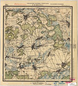
- Russian
- Identifier:
- VAC9619-001571
- Genre:
- Topographic Maps and Military Maps
- Geographic Location:
- Coordinates: 52.1667, 31.25, 52.3333, 31.5
- Related URL:
- DataCORE Dataset Download: https://datacore.iu.edu/concern/data_sets/8623hz451
- Abstract:
- Modern area represented: Nasovichy, Homyel Voblasc, Belarus
- Call Number:
- G7000 s50 .S68 sheet N-36-135-Б
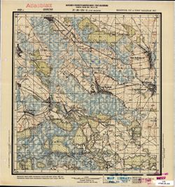
- Caption:
- Не подлежит оглашению
- City:
- М. Носовичи (Nasovichy)
- Copyright Holder:
- No Copyright - United States
- Country:
- СССР (USSR)
- State/Province:
- Белорусская ССР (Byelorussian Soviet Socialist Republic)
- Physical Description:
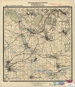
- Scale: 1:50,000
- Persistent URL:
- http://purl.dlib.indiana.edu/iudl/images/VAC9619/VAC9619-001571
- Provenance:
- M. I. Map Library, Atlasblatt
-
- Description:
- 1929
- Subject:
- Geographic Subject: Sharpilovka, Topical Subject: Maps, and Topical Subject: Soviet Union
- Publisher:
- Военно-топографическое управление
- Language:
- Russian
- Identifier:
- VAC9619-001569
- Genre:
- Topographic Maps and Military Maps
- Geographic Location:
- Coordinates: 52, 30.75, 52.1667, 31
- Related URL:
- DataCORE Dataset Download: https://datacore.iu.edu/concern/data_sets/j96021409
- Abstract:
- Modern area represented: Sharpilovka, Homyel oblast, Belarus
- Call Number:
- G7000 s50 .S68 sheet N-36-134-D
- Caption:
- Не подлежит оглашению
- City:
- Шарпиловка (Sharpilovka)
- Copyright Holder:
- No Copyright - United States
- Country:
- СССР (USSR)
- State/Province:
- Белорусская ССР (Byelorussian Soviet Socialist Republic) and Украинская ССР (Ukrainian Soviet Socialist Republic)
- Physical Description:
- Scale: 1:50,000
- Persistent URL:
- http://purl.dlib.indiana.edu/iudl/images/VAC9619/VAC9619-001569
- Provenance:
- M. I. Map Library, G000-30, GS, RA
-
- Description:
- 1923
- Subject:
- Topical Subject: Maps, Topical Subject: Soviet Union, and Geographic Subject: Hrabawka
- Publisher:
- Управление военных топографов
- Language:
- Russian
- Date Created:
- 1924
- Identifier:
- VAC9619-001570
- Genre:
- Military Maps and Topographic Maps
- Geographic Location:
- Coordinates: 52.1667, 31, 52.3333, 31.25
- Related URL:
- DataCORE Dataset Download: https://datacore.iu.edu/concern/data_sets/0r967449r
- Abstract:
- Modern area represented: Hrabawka, Homyel Voblasc, Belarus
- Call Number:
- G7000 s50 .S68 sheet N-36-135-A
- Caption:
- Не подлежит оглашению
- City:
- Грабовка (Hrabawka)
- Copyright Holder:
- No Copyright - United States
- Country:
- СССР (USSR)
- State/Province:
- Белорусская ССР (Byelorussian Soviet Socialist Republic)
- Physical Description:
- Scale: 1:50,000
- Persistent URL:
- http://purl.dlib.indiana.edu/iudl/images/VAC9619/VAC9619-001570
- Provenance:
- G000-30
-
- Description:
- 1929
- Subject:
- Topical Subject: Soviet Union, Geographic Subject: Kholmyech, and Topical Subject: Maps
- Publisher:
- Военно-топографическое управление
- Language:
- Russian
- Identifier:
- VAC9619-001568
- Genre:
- Military Maps and Topographic Maps
- Geographic Location:
- Coordinates: 52, 30.5, 52.1667, 30.75
- Related URL:
- DataCORE Dataset Download: https://datacore.iu.edu/concern/data_sets/h415pb21v
- Abstract:
- Modern area represented: Kholmyech, Homyel Voblasc, Belarus
- Call Number:
- G7000 s50 .S68 sheet N-36-134-В
- Caption:
- Секретно
- City:
- М. Холмечь (Kholmyech)
- Copyright Holder:
- No Copyright - United States
- Country:
- СССР (USSR)
- State/Province:
- Белорусская ССР (Byelorussian Soviet Socialist Republic)
- Physical Description:
- Scale: 1:50,000
- Persistent URL:
- http://purl.dlib.indiana.edu/iudl/images/VAC9619/VAC9619-001568
- Provenance:
- M. I. Map Library, GS, RA
-
- Description:
- 1929
- Subject:
- Topical Subject: Maps, Topical Subject: Soviet Union, and Geographic Subject: Chkalovo
- Publisher:
- Управление военных топографов
- Language:
- Russian
- Identifier:
- VAC9619-001567
- Genre:
- Military Maps and Topographic Maps
- Geographic Location:
- Coordinates: 52.1667, 30.75, 52.3333, 31
- Related URL:
- DataCORE Dataset Download: https://datacore.iu.edu/concern/data_sets/td96k3416
- Abstract:
- Modern area represented: Chkalovo, Homyel Voblasc, Belarus
- Call Number:
- G7000 s50 .S68 sheet N-36-134-Б
- Caption:
- Не подлежит оглашению
- City:
- Жеребная (Zherebnaya)
- Copyright Holder:
- No Copyright - United States
- Country:
- СССР (USSR)
- State/Province:
- Белорусская ССР (Byelorussian Soviet Socialist Republic)
- Physical Description:
- Scale: 1:50,000
- Persistent URL:
- http://purl.dlib.indiana.edu/iudl/images/VAC9619/VAC9619-001567
- Provenance:
- M. I. Map Library, Atlasblatt
-
- Description:
- 1929
- Subject:
- Topical Subject: Soviet Union, Geographic Subject: Novyy Barsuk, and Topical Subject: Maps
- Publisher:
- Управление военных топографов
- Language:
- Russian
- Date Created:
- 1930
- Identifier:
- VAC9619-001565
- Genre:
- Military Maps and Topographic Maps
- Geographic Location:
- Coordinates: 52, 30.25, 52.1667, 30.5
- Related URL:
- DataCORE Dataset Download: https://datacore.iu.edu/concern/data_sets/fx719n21d
- Abstract:
- Modern area represented: Novyy Barsuk, Homyel Voblasc, Belarus
- Call Number:
- G7000 s50 .S68 sheet N-36-133-Г
- Caption:
- Не подлежит оглашению
- City:
- Нов. Барсук (Novyy Barsuk)
- Copyright Holder:
- No Copyright - United States
- Country:
- СССР (USSR)
- State/Province:
- Белорусская ССР (Byelorussian Soviet Socialist Republic)
- Physical Description:
- Scale: 1:50,000
- Persistent URL:
- http://purl.dlib.indiana.edu/iudl/images/VAC9619/VAC9619-001565
- Provenance:
- M. I. Map Library, G000-30
-
- Description:
- 1929
- Subject:
- Topical Subject: Maps, Topical Subject: Soviet Union, and Geographic Subject: Vetkhin
- Publisher:
- Управление военных топографов
- Language:
- Russian
- Identifier:
- VAC9619-001566
- Genre:
- Military Maps and Topographic Maps
- Geographic Location:
- Coordinates: 52.1667, 30.5, 52.3333, 30.75
- Related URL:
- DataCORE Dataset Download: https://datacore.iu.edu/concern/data_sets/vd66w050t
- Abstract:
- Modern area represented: Vetkhin, Homyel Voblasc, Belarus
- Call Number:
- G7000 s50 .S68 sheet N-36-134-A
- Caption:
- Не подлежит оглашению
- Copyright Holder:
- No Copyright - United States
- Country:
- СССР (USSR)
- State/Province:
- Белорусская ССР (Byelorussian Soviet Socialist Republic)
- Physical Description:
- Scale: 1:50,000
- Persistent URL:
- http://purl.dlib.indiana.edu/iudl/images/VAC9619/VAC9619-001566
- Provenance:
- M. I. Map Library, Atlasblatt
-
- Description:
- 1930
- Subject:
- Topical Subject: Maps, Topical Subject: Soviet Union, and Geographic Subject: Omelkovshchina
- Publisher:
- Управление военных топографов
- Language:
- Russian
- Date Created:
- 1931
- Identifier:
- VAC9619-001564
- Genre:
- Military Maps and Topographic Maps
- Geographic Location:
- Coordinates: 52, 30, 52.1667, 30.25
- Related URL:
- DataCORE Dataset Download: https://datacore.iu.edu/concern/data_sets/7p88ch422
- Abstract:
- Modern area represented: Omelkovshchina, Homyel Voblasc, Belarus
- Call Number:
- G7000 s50 .S68 sheet N-36-133-B
- Caption:
- Не подлежит оглашению
- City:
- Омельковщина (Omelkovshchina)
- Copyright Holder:
- No Copyright - United States
- Country:
- СССР (USSR)
- State/Province:
- Белорусская ССР (Byelorussian Soviet Socialist Republic)
- Physical Description:
- Scale: 1:50,000
- Persistent URL:
- http://purl.dlib.indiana.edu/iudl/images/VAC9619/VAC9619-001564
- Provenance:
- M. I. Map Library, GS, RA
-
- Description:
- 1929
- Subject:
- Geographic Subject: Bronnoye, Topical Subject: Soviet Union, and Topical Subject: Maps
- Publisher:
- Управление военных топографов
- Language:
- Russian
- Date Created:
- 1934
- Identifier:
- VAC9619-001563
- Genre:
- Topographic Maps and Military Maps
- Geographic Location:
- Coordinates: 52.1667, 30.25, 52.3333, 30.5
- Related URL:
- DataCORE Dataset Download: https://datacore.iu.edu/concern/data_sets/j38607634
- Abstract:
- Modern area represented: Bronnoye, Homyel Voblasc, Belarus
- Call Number:
- G7000 s50 .S68 sheet N-36-133-Б
- Caption:
- Не подлежит оглашению
- City:
- Бронное (Bronnoye)
- Copyright Holder:
- No Copyright - United States
- Country:
- СССР (USSR)
- State/Province:
- Белорусская ССР (Byelorussian Soviet Socialist Republic)
- Physical Description:
- Scale: 1:50,000
- Persistent URL:
- http://purl.dlib.indiana.edu/iudl/images/VAC9619/VAC9619-001563
- Provenance:
- M. I. Map Library, GS, RA
-
- Description:
- 1930
- Subject:
- Topical Subject: Maps, Geographic Subject: Korovatichi, and Topical Subject: Soviet Union
- Publisher:
- Управление военных топографов
- Language:
- Russian
- Date Created:
- 1931
- Identifier:
- VAC9619-001562
- Genre:
- Topographic Maps and Military Maps
- Geographic Location:
- Coordinates: 52.1667, 30, 52.3333, 30.25
- Related URL:
- DataCORE Dataset Download: https://datacore.iu.edu/concern/data_sets/2r36tz39v
- Abstract:
- Modern area represented: Korovatichi, Homyel Voblasc, Belarus
- Call Number:
- G7000 s50 .S68 sheet N-36-133-A
- Caption:
- Не подлежит оглашению
- City:
- Короватичи (Korovatichi)
- Copyright Holder:
- No Copyright - United States
- Country:
- СССР (USSR)
- State/Province:
- Белорусская ССР (Byelorussian Soviet Socialist Republic)
- Physical Description:
- Scale: 1:50,000
- Persistent URL:
- http://purl.dlib.indiana.edu/iudl/images/VAC9619/VAC9619-001562
- Provenance:
- CIA Map Branch -- Received, FEM Austria
-
- Description:
- 1940
- Subject:
- Geographic Subject: Kokorevka, Topical Subject: Soviet Union, and Topical Subject: Maps
- Publisher:
- Главное Управление Геодезии и Картографии при СНК СССР
- Language:
- Russian
- Date Created:
- 1941
- Identifier:
- VAC9619-001561
- Genre:
- Military Maps and Topographic Maps
- Geographic Location:
- Coordinates: 52.5, 34.25, 52.6667, 34.5
- Related URL:
- DataCORE Dataset Download: https://datacore.iu.edu/concern/data_sets/zs25x930p
- Abstract:
- Modern area represented: Kokorevka, Bryansk oblast, Russia
- Call Number:
- G7000 s50 .S68 sheet N-36-129-B
- City:
- Кокоревка (Kokorevka)
- Copyright Holder:
- No Copyright - United States
- Country:
- СССР (USSR)
- State/Province:
- Орловская область (Oryol oblast) and РСФСР (RSFSR)
- Physical Description:
- Scale: 1:50,000
- Persistent URL:
- http://purl.dlib.indiana.edu/iudl/images/VAC9619/VAC9619-001561
- Provenance:
- DMA Topographic Center, Army Map Service Library, OMAHA, Library of Congress Geography & Map Division
-
- Description:
- 1928
- Subject:
- Geographic Subject: Klimovo, Topical Subject: Maps, and Topical Subject: Soviet Union
- Publisher:
- Управление военных топографов
- Language:
- Russian
- Identifier:
- VAC9619-001560
- Genre:
- Topographic Maps and Military Maps
- Geographic Location:
- Coordinates: 52.3333, 32, 52.5, 32.25
- Related URL:
- DataCORE Dataset Download: https://datacore.iu.edu/concern/data_sets/np193999d
- Abstract:
- Modern area represented: Klimovo, Bryansk oblast, Russia
- Call Number:
- G7000 s50 .S68 sheet N-36-125-B
- Caption:
- Не подлежит оглашению
- City:
- Климов ( Klimov)
- Copyright Holder:
- No Copyright - United States
- Country:
- СССР (USSR)
- State/Province:
- Западная область (Western oblast) and РСФСР (RSFSR)
- Physical Description:
- Scale: 1:50,000
- Persistent URL:
- http://purl.dlib.indiana.edu/iudl/images/VAC9619/VAC9619-001560
- Provenance:
- M. I. Map Library, Atlasblatt, GS, RA
-
- Description:
- 1936
- Subject:
- Topical Subject: Soviet Union, Topical Subject: Maps, and Geographic Subject: Qaradonlu
- Publisher:
- Генеральный штаб РККА
- Language:
- Russian
- Identifier:
- VAC9619-001559
- Genre:
- Military Maps and Topographic Maps
- Geographic Location:
- Coordinates: 39.66667, 48.0, 40.0, 48.5
- Related URL:
- DataCORE Dataset Download: https://datacore.iu.edu/concern/data_sets/tb09j630g
- Abstract:
- Modern area represented: Qaradonlu, Imishli district, Azerbaijan
- Call Number:
- G7000 s100 .S7 sheet J-39-1
- Caption:
- Не подлежит оглашению
- City:
- Карадонлы (Qaradonlu)
- Copyright Holder:
- No Copyright - United States
- Country:
- Иран (Iran)
- State/Province:
- Азербайджанская ССР (Azerbaijan Soviet Socialist Republic)
- Physical Description:
- Scale: 1:100,000
- Persistent URL:
- http://purl.dlib.indiana.edu/iudl/images/VAC9619/VAC9619-001559
- Provenance:
- DMA Topographic Center, Auswärtiges Amt. Geographischer Dienst, OMAHA, Army Map Service Library, Library of Congress Geography & Map Division
-
- Description:
- 1928
- Subject:
- Topical Subject: Maps, Topical Subject: Soviet Union, and Geographic Subject: Zlynka
- Publisher:
- Военно-топографическое управление
- Language:
- Russian
- Identifier:
- VAC9619-001557
- Genre:
- Military Maps and Topographic Maps
- Geographic Location:
- Coordinates: 52.3333, 31.5, 52.5, 31.75
- Related URL:
- DataCORE Dataset Download: https://datacore.iu.edu/concern/data_sets/zc77sq77b
- Abstract:
- Modern area represented: Zlynka, Bryansk oblast, Russia
- Call Number:
- G7000 s50 .S68 sheet N-36-124-В
- Caption:
- Не подлежит оглашению
- City:
- Злынка (Zlynka)
- Copyright Holder:
- No Copyright - United States
- Country:
- СССР (USSR)
- State/Province:
- РСФСР (RSFSR), Белорусская ССР (Byelorussian Soviet Socialist Republic), and Западная область (Western oblast)
- Physical Description:
- Scale: 1:50,000
- Persistent URL:
- http://purl.dlib.indiana.edu/iudl/images/VAC9619/VAC9619-001557
- Provenance:
- M. I. Map Library, Atlasblatt, GS, RA
-
- Description:
- 1923
- Subject:
- Geographic Subject: Katashin, Topical Subject: Soviet Union, and Topical Subject: Maps
- Publisher:
- Военно-топографическое управление
- Language:
- Russian
- Identifier:
- VAC9619-001558
- Genre:
- Military Maps and Topographic Maps
- Geographic Location:
- Coordinates: 52.5, 32, 52.6667, 32.25
- Related URL:
- DataCORE Dataset Download: https://datacore.iu.edu/concern/data_sets/9306t004k
- Abstract:
- Modern area represented: Katashin, Bryansk oblast, Russia
- Call Number:
- G7000 s50 .S68 sheet N-36-125-A
- Caption:
- Не подлежит оглашению
- City:
- Каташин (Katashin)
- Copyright Holder:
- No Copyright - United States
- Country:
- СССР (USSR)
- State/Province:
- Западная область (Western oblast) and РСФСР (RSFSR)
- Physical Description:
- Scale: 1:50,000
- Persistent URL:
- http://purl.dlib.indiana.edu/iudl/images/VAC9619/VAC9619-001558
- Provenance:
- M. I. Map Library, Atlasblatt, GS, RA
-
- Description:
- 1923
- Subject:
- Topical Subject: Soviet Union, Geographic Subject: Staryy Vyshkov, and Topical Subject: Maps
- Publisher:
- Военно-топографическое управление
- Language:
- Russian
- Identifier:
- VAC9619-001556
- Genre:
- Topographic Maps and Military Maps
- Geographic Location:
- Coordinates: 52.5, 31.5, 52.6667, 31.75
- Related URL:
- DataCORE Dataset Download: https://datacore.iu.edu/concern/data_sets/br86b437q
- Abstract:
- Modern area represented: Staryy Vyshkov, Bryansk oblast, Russia
- Call Number:
- G7000 s50 .S68 sheet N-36-124-A
- Caption:
- Секретно
- City:
- Стар. Вышков (Staryy Vyshkov)
- Copyright Holder:
- No Copyright - United States
- Country:
- СССР (USSR)
- State/Province:
- Западная область (Western oblast), Белорусская ССР (Byelorussian Soviet Socialist Republic), and РСФСР (RSFSR)
- Physical Description:
- Scale: 1:50,000
- Persistent URL:
- http://purl.dlib.indiana.edu/iudl/images/VAC9619/VAC9619-001556
- Provenance:
- M. I. Map Library, Atlasblatt, GS, RA
-
- Description:
- 1923
- Subject:
- Topical Subject: Maps, Topical Subject: Soviet Union, and Geographic Subject: Sivinka
- Publisher:
- Управление военных топографов
- Language:
- Russian
- Identifier:
- VAC9619-001555
- Genre:
- Military Maps and Topographic Maps
- Geographic Location:
- Coordinates: 52.5, 31.25, 52.6667, 31.5
- Related URL:
- DataCORE Dataset Download: https://datacore.iu.edu/concern/data_sets/736665131
- Abstract:
- Modern area represented: Sivinka, Homyel Voblasc, Belarus
- Call Number:
- G7000 s50 .S68 sheet N-36-123-Б
- Caption:
- Не подлежит оглашению
- City:
- Савинка (Savinka)
- Copyright Holder:
- No Copyright - United States
- Country:
- СССР (USSR)
- State/Province:
- Белорусская ССР (Byelorussian Soviet Socialist Republic)
- Physical Description:
- Scale: 1:50,000
- Persistent URL:
- http://purl.dlib.indiana.edu/iudl/images/VAC9619/VAC9619-001555
- Provenance:
- M. I. Map Library, Atlasblatt, GS, RA
-
- Description:
- 1926
- Subject:
- Topical Subject: Soviet Union, Topical Subject: Maps, and Geographic Subject: Barshchowka
- Publisher:
- Военно-топографическое управление
- Language:
- Russian
- Identifier:
- VAC9619-001553
- Genre:
- Topographic Maps and Military Maps
- Geographic Location:
- Coordinates: 52.3333, 30.5, 52.5, 30.75
- Related URL:
- DataCORE Dataset Download: https://datacore.iu.edu/concern/data_sets/sq87bv326
- Abstract:
- Modern area represented: Barshchowka, Homyel oblast, Belarus
- Call Number:
- G7000 s50 .S68 sheet N-36-122-C
- Caption:
- Секретно
- City:
- Борщовка (Barshchowka)
- Copyright Holder:
- No Copyright - United States
- Country:
- СССР (USSR)
- State/Province:
- Белорусская ССР (Byelorussian Soviet Socialist Republic)
- Physical Description:
- Scale: 1:50,000
- Persistent URL:
- http://purl.dlib.indiana.edu/iudl/images/VAC9619/VAC9619-001553
- Provenance:
- Army Map Service Library, Library of Congress Geography & Map Division, OMAHA
-
- Description:
- 1923
- Subject:
- Topical Subject: Soviet Union, Geographic Subject: Vyetka, and Topical Subject: Maps
- Publisher:
- Управление военных топографов
- Language:
- Russian
- Identifier:
- VAC9619-001554
- Genre:
- Topographic Maps and Military Maps
- Geographic Location:
- Coordinates: 52.5, 31, 52.6667, 31.25
- Related URL:
- DataCORE Dataset Download: https://datacore.iu.edu/concern/data_sets/pn89d739s
- Abstract:
- Modern area represented: Vyetka, Homyel oblast, Belarus
- Call Number:
- G7000 s50 .S68 sheet N-36-123-A
- Caption:
- Не подлежит оглашению
- City:
- Ветка (Vyetka)
- Copyright Holder:
- No Copyright - United States
- Country:
- СССР (USSR)
- State/Province:
- Белорусская ССР (Byelorussian Soviet Socialist Republic)
- Physical Description:
- Scale: 1:50,000
- Persistent URL:
- http://purl.dlib.indiana.edu/iudl/images/VAC9619/VAC9619-001554
- Provenance:
- CIA Map Branch -- Received
-
- Description:
- 1923
- Subject:
- Topical Subject: Maps, Geographic Subject: Yaromina, and Topical Subject: Soviet Union
- Publisher:
- Управление военных топографов РККА
- Language:
- Russian
- Identifier:
- VAC9619-001552
- Genre:
- Military Maps and Topographic Maps
- Geographic Location:
- Coordinates: 52.5, 30.75, 52.6667, 31
- Related URL:
- DataCORE Dataset Download: https://datacore.iu.edu/concern/data_sets/k35694995
- Abstract:
- Modern area represented: Yaromina, Homyel oblast, Belarus
- Call Number:
- G7000 s50 .S68 sheet N-36-122-B
- Caption:
- Не подлежит оглашению
- City:
- Еремино (Yaromina)
- Copyright Holder:
- No Copyright - United States
- Country:
- СССР (USSR)
- State/Province:
- Белорусская ССР (Byelorussian Soviet Socialist Republic)
- Physical Description:
- Scale: 1:50,000
- Persistent URL:
- http://purl.dlib.indiana.edu/iudl/images/VAC9619/VAC9619-001552
- Provenance:
- M. I. Map Library, Atlasblatt
-
- Description:
- 1926
- Subject:
- Geographic Subject: Rechytsa, Topical Subject: Soviet Union, and Topical Subject: Maps
- Publisher:
- Управление военных топографов
- Language:
- Russian
- Date Created:
- 1934
- Identifier:
- VAC9619-001551
- Genre:
- Topographic Maps and Military Maps
- Geographic Location:
- Coordinates: 52.3333, 30.25, 52.5, 30.5
- Related URL:
- DataCORE Dataset Download: https://datacore.iu.edu/concern/data_sets/bk128b62b
- Abstract:
- Modern area represented: Rechytsa, Homyel oblast, Belarus
- Call Number:
- G7000 s50 .S68 sheet N-36-121-D
- Caption:
- Не подлежит оглашению
- City:
- Речица (Rechytsa)
- Copyright Holder:
- No Copyright - United States
- Country:
- СССР (USSR)
- State/Province:
- Белорусская ССР (Byelorussian Soviet Socialist Republic)
- Physical Description:
- Scale: 1:50,000
- Persistent URL:
- http://purl.dlib.indiana.edu/iudl/images/VAC9619/VAC9619-001551
- Provenance:
- CIA Map Branch -- Received
-

- Description:
- 1930
- Subject:
- Topical Subject: Soviet Union, Topical Subject: Maps, and Geographic Subject: Volodarsk
- Publisher:
- Управление военных топографов РККА
- Language:
- Russian
- Date Created:
- 1931
- Identifier:
- VAC9619-001550
- Genre:
- Military Maps and Topographic Maps
- Geographic Location:
- Coordinates: 52.3333, 30, 52.5, 30.25
- Related URL:
- DataCORE Dataset Download: https://datacore.iu.edu/concern/data_sets/k3569498w
- Abstract:
- Modern area represented: Volodarsk, Homyel oblast, Belarus
- Call Number:
- G7000 s50 .S68 sheet N-36-121-C
- Caption:
- Не подлежит оглашению
- City:
- Гавеновичи (Gavenovichi)
- Copyright Holder:
- No Copyright - United States
- Country:
- СССР (USSR)
- State/Province:
- Белорусская ССР (Byelorussian Soviet Socialist Republic)
- Physical Description:
- Scale: 1:50,000
- Persistent URL:
- http://purl.dlib.indiana.edu/iudl/images/VAC9619/VAC9619-001550
- Provenance:
- Army Map Service Library, Library of Congress Geography & Map Division, OMAHA
-
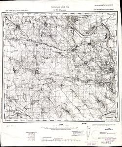
- Description:
- 1875
- Subject:
- Topical Subject: Maps, Topical Subject: Soviet Union, and Geographic Subject: Tighina
- Publisher:
- Генеральный штаб РККА
- Language:
- Russian
- Date Created:
- 1940
- Identifier:
- VAC9619-001549
- Genre:
- Military Maps and Topographic Maps
- Geographic Location:
- Coordinates: 46.6667, 29, 47, 29.5
- Related URL:
- DataCORE Dataset Download: https://datacore.iu.edu/concern/data_sets/h702q7281
- Abstract:
- Modern area represented: Tighina, Bender municipality, Moldova
- Call Number:
- G7000 s100 .S7 sheet L-35-47
- Caption:
- Не подлежит оглашению
- City:
- Бендеры (Bendery)
- Copyright Holder:
- No Copyright - United States
- State/Province:
- Бессарабия (Bessarabia), Украинская ССР (Ukrainian Soviet Socialist Republic), and Молдавская АССР (Moldavian Autonomous Soviet Socialist Republic)
- Physical Description:
- Scale: 1:100,000
- Persistent URL:
- http://purl.dlib.indiana.edu/iudl/images/VAC9619/VAC9619-001549
- Provenance:
- CIA Map Library, Geographisches Institut der Universität Berlin
-

- Description:
- 1936
- Subject:
- Topical Subject: Maps, Topical Subject: Soviet Union, and Geographic Subject: Chebotovichi
- Publisher:
- Управление военных топографов РККА
- Language:
- Russian
- Identifier:
- VAC9619-001548
- Genre:
- Military Maps and Topographic Maps
- Geographic Location:
- Coordinates: 52.5, 30.25, 52.6667, 30.5
- Related URL:
- DataCORE Dataset Download: https://datacore.iu.edu/concern/data_sets/dz010q70h
- Abstract:
- Modern area represented: Chebotovichi, Homyel oblast, Belarus
- Call Number:
- G7000 s50 .S68 sheet N-36-121-B
- Caption:
- Не подлежит оглашению
- City:
- Чеботовичи (Chebotovichi)
- Copyright Holder:
- No Copyright - United States
- Country:
- СССР (USSR)
- State/Province:
- Белорусская ССР (Byelorussian Soviet Socialist Republic)
- Physical Description:
- Scale: 1:50,000
- Persistent URL:
- http://purl.dlib.indiana.edu/iudl/images/VAC9619/VAC9619-001548
- Provenance:
- Army Map Service Library, Library of Congress Geography & Map Division, OMAHA
-

- Description:
- 1926
- Subject:
- Geographic Subject: Gorval, Topical Subject: Maps, and Topical Subject: Soviet Union
- Publisher:
- Управление военных топографов РККА
- Language:
- Russian
- Date Created:
- 1936
- Identifier:
- VAC9619-001547
- Genre:
- Military Maps and Topographic Maps
- Geographic Location:
- Coordinates: 52.5, 30, 52.6667, 30.25
- Related URL:
- DataCORE Dataset Download: https://datacore.iu.edu/concern/data_sets/kd17ct58r
- Abstract:
- Modern area represented: Gorval, Homyel oblast, Belarus
- Call Number:
- G7000 s50 .S68 sheet N-36-121-A
- Caption:
- Не подлежит оглашению
- City:
- Горваль (Gorval)
- Copyright Holder:
- No Copyright - United States
- Country:
- СССР (USSR)
- State/Province:
- Белорусская ССР (Byelorussian Soviet Socialist Republic)
- Physical Description:
- Scale: 1:50,000
- Persistent URL:
- http://purl.dlib.indiana.edu/iudl/images/VAC9619/VAC9619-001547
- Provenance:
- Army Map Service Library, Library of Congress Geography & Map Division, OMAHA
-
- Description:
- 1930
- Subject:
- Topical Subject: Maps, Geographic Subject: Navlya, and Topical Subject: Soviet Union
- Publisher:
- Генеральный штаб РККА
- Language:
- Russian
- Identifier:
- VAC9619-001546
- Genre:
- Military Maps and Topographic Maps
- Geographic Location:
- Coordinates: 52.6667, 34.25, 52.8667, 34.5
- Related URL:
- DataCORE Dataset Download: https://datacore.iu.edu/concern/data_sets/2b88qd00s
- Abstract:
- Modern area represented: Navlya, Bryansk oblast, Russia
- Call Number:
- G7000 s50 .S68 sheet N-36-117-D
- Caption:
- Не подлежит оглашению
- City:
- Навля (Navlya)
- Copyright Holder:
- No Copyright - United States
- Country:
- СССР (USSR)
- State/Province:
- Западная область (Western oblast) and РСФСР (RSFSR)
- Physical Description:
- Scale: 1:50,000
- Persistent URL:
- http://purl.dlib.indiana.edu/iudl/images/VAC9619/VAC9619-001546
- Provenance:
- Army Map Service Library, Library of Congress Geography & Map Division, OMAHA
-
- Description:
- 1930
- Subject:
- Topical Subject: Soviet Union, Geographic Subject: Glinnoye, and Topical Subject: Maps
- Publisher:
- Управление военных топографов
- Language:
- Russian
- Identifier:
- VAC9619-001545
- Genre:
- Topographic Maps and Military Maps
- Geographic Location:
- Coordinates: 52.6667, 34, 52.8667, 34.25
- Related URL:
- DataCORE Dataset Download: https://datacore.iu.edu/concern/data_sets/dz010q69r
- Abstract:
- Modern area represented: Glinnoye, Bryansk oblast, Russia
- Call Number:
- G7000 s50 .S68 sheet N-36-117-C
- Caption:
- Не подлежит оглашению
- City:
- Глинное (Glinnoye)
- Copyright Holder:
- No Copyright - United States
- Country:
- СССР (USSR)
- State/Province:
- Западная область (Western oblast) and РСФСР (RSFSR)
- Physical Description:
- Scale: 1:50,000
- Persistent URL:
- http://purl.dlib.indiana.edu/iudl/images/VAC9619/VAC9619-001545
- Provenance:
- Army Map Service Library, Library of Congress Geography & Map Division, OMAHA
-
- Description:
- 1930
- Subject:
- Topical Subject: Soviet Union, Topical Subject: Maps, and Geographic Subject: Pervomayskoye
- Publisher:
- Генеральный штаб Красной Армии
- Language:
- Russian
- Date Created:
- 1934
- Identifier:
- VAC9619-001544
- Genre:
- Topographic Maps and Military Maps
- Geographic Location:
- Coordinates: 52.8667, 33.5, 53, 33.75
- Related URL:
- DataCORE Dataset Download: https://datacore.iu.edu/concern/data_sets/2v23vv13z
- Abstract:
- Modern area represented: Pervomayskoye, Bryansk oblast, Russia
- Call Number:
- G7000 s50 .S68 sheet N-36-116-A
- City:
- Пьяный Рог (Pyany Rog)
- Copyright Holder:
- No Copyright - United States
- Country:
- СССР (USSR)
- State/Province:
- РСФСР (RSFSR) and Орловская область (Oryol oblast)
- Physical Description:
- Scale: 1:50,000
- Persistent URL:
- http://purl.dlib.indiana.edu/iudl/images/VAC9619/VAC9619-001544
- Provenance:
- DMA Topographic Center, Army Map Service Library, OMAHA, Library of Congress Geography & Map Division
-
- Description:
- 1930
- Subject:
- Topical Subject: Maps, Geographic Subject: Baklan, and Topical Subject: Soviet Union
- Publisher:
- Управление военных топографов
- Language:
- Russian
- Identifier:
- VAC9619-001543
- Genre:
- Topographic Maps and Military Maps
- Geographic Location:
- Coordinates: 52.6667, 33.25, 52.8667, 33.5
- Related URL:
- DataCORE Dataset Download: https://datacore.iu.edu/concern/data_sets/0c483k123
- Abstract:
- Modern area represented: Baklan, Bryansk oblast, Russia
- Call Number:
- G7000 s50 .S68 sheet N-36-115-D
- Caption:
- Не подлежит оглашению
- City:
- Баклань (Baklan)
- Copyright Holder:
- No Copyright - United States
- Country:
- СССР (USSR)
- State/Province:
- Западная область (Western oblast) and РСФСР (RSFSR)
- Physical Description:
- Scale: 1:50,000
- Persistent URL:
- http://purl.dlib.indiana.edu/iudl/images/VAC9619/VAC9619-001543
- Provenance:
- DMA Topographic Center, Army Map Service Library, Library of Congress Geography & Map Division
-
- Description:
- 1930
- Subject:
- Topical Subject: Soviet Union, Topical Subject: Maps, and Geographic Subject: Savostyany
- Publisher:
- Генеральный штаб Красной Армии
- Language:
- Russian
- Identifier:
- VAC9619-001542
- Genre:
- Topographic Maps and Military Maps
- Geographic Location:
- Coordinates: 52.6667, 33, 52.8667, 33.25
- Related URL:
- DataCORE Dataset Download: https://datacore.iu.edu/concern/data_sets/n583xv67f
- Abstract:
- Modern area represented: Savostyany, Bryansk oblast, Russia
- Call Number:
- G7000 s50 .S68 sheet N-36-115-C
- City:
- Севостьяны (Savostyany)
- Copyright Holder:
- No Copyright - United States
- Country:
- СССР (USSR)
- State/Province:
- РСФСР (RSFSR) and Орловская область (Oryol oblast)
- Physical Description:
- Scale: 1:50,000
- Persistent URL:
- http://purl.dlib.indiana.edu/iudl/images/VAC9619/VAC9619-001542
- Provenance:
- DMA Topographic Center, Army Map Service Library, Library of Congress Geography & Map Division
-
- Description:
- 1894
- Subject:
- Topical Subject: Soviet Union, Topical Subject: Maps, and Geographic Subject: Negreşti
- Publisher:
- Генеральный штаб РККА
- Language:
- Russian
- Date Created:
- 1895
- Identifier:
- VAC9619-001541
- Genre:
- Military Maps and Topographic Maps
- Geographic Location:
- Coordinates: 46.6667, 27, 47, 27.5
- Related URL:
- DataCORE Dataset Download: https://datacore.iu.edu/concern/data_sets/ww72bc30d
- Abstract:
- Modern area represented: Negreşti, Strășeni district, Moldova
- Call Number:
- G7000 s100 .S7 sheet L-35-43
- City:
- Негрешть (Negreşti)
- Copyright Holder:
- No Copyright - United States
- Country:
- Румыния (Romania)
- Physical Description:
- Scale: 1:100,000
- Persistent URL:
- http://purl.dlib.indiana.edu/iudl/images/VAC9619/VAC9619-001541
- Provenance:
- DMA Topographic Center, Army Map Service Library, Library of Congress Geography & Map Division
-
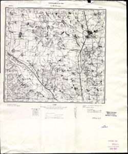
- Description:
- 1888
- Subject:
- Topical Subject: Maps, Geographic Subject: Roman, and Topical Subject: Soviet Union
- Publisher:
- Генеральный штаб РККА
- Language:
- Russian
- Date Created:
- 1940
- Identifier:
- VAC9619-001540
- Genre:
- Military Maps and Topographic Maps
- Geographic Location:
- Coordinates: 46.6667, 26.5, 47, 27
- Related URL:
- DataCORE Dataset Download: https://datacore.iu.edu/concern/data_sets/v405sb07s
- Abstract:
- Modern area represented: Roman, Neamţ county, Romania
- Call Number:
- G7000 s100 .S7 sheet L-35-42
- City:
- Роман (Roman)
- Copyright Holder:
- No Copyright - United States
- Country:
- Румыния (Romania)
- Physical Description:
- Scale: 1:100,000
- Persistent URL:
- http://purl.dlib.indiana.edu/iudl/images/VAC9619/VAC9619-001540
- Provenance:
- CIA Map Library
-
- Description:
- 1931
- Subject:
- Topical Subject: Soviet Union, Topical Subject: Maps, and Geographic Subject: Korzhovka-Golubovka
- Publisher:
- Управление военных топографов
- Language:
- Russian
- Identifier:
- VAC9619-001539
- Genre:
- Topographic Maps and Military Maps
- Geographic Location:
- Coordinates: 52.6667, 32.25, 52.8667, 32.5
- Related URL:
- DataCORE Dataset Download: https://datacore.iu.edu/concern/data_sets/6q182k74h
- Abstract:
- Modern area represented: Korzhovka-Golubovka, Bryansk oblast, Russia
- Call Number:
- G7000 s50 .S68 sheet N-36-113-D
- Caption:
- Временное издание,Не подлежит оглашению
- City:
- Коржовка-Голубовка (Korzhovka-Golubovka)
- Copyright Holder:
- No Copyright - United States
- Country:
- СССР (USSR)
- State/Province:
- РСФСР (RSFSR) and Западная область (Western oblast)
- Physical Description:
- Scale: 1:50,000
- Persistent URL:
- http://purl.dlib.indiana.edu/iudl/images/VAC9619/VAC9619-001539
- Provenance:
- DMA Topographic Center, Army Map Service Library, OMAHA, Library of Congress Geography & Map Division
-
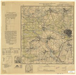
- Description:
- 1931
- Subject:
- Geographic Subject: Klintsy, Topical Subject: Soviet Union, and Topical Subject: Maps
- Publisher:
- Управление военных топографов
- Language:
- Russian
- Identifier:
- VAC9619-001538
- Genre:
- Military Maps and Topographic Maps
- Geographic Location:
- Coordinates: 52.6667, 32, 52.8883, 32.25
- Related URL:
- DataCORE Dataset Download: https://datacore.iu.edu/concern/data_sets/3n203z69v
- Abstract:
- Modern area represented: Klintsy, Bryansk oblast, Russia
- Call Number:
- G7000 s50 .S68 sheet N-36-113-D
- Caption:
- Временное издание,Не подлежит оглашению
- City:
- Клинцы (Klintsy)
- Copyright Holder:
- No Copyright - United States
- Country:
- СССР (USSR)
- State/Province:
- Западная область (Western oblast) and РСФСР (RSFSR)
- Physical Description:
- Scale: 1:50,000
- Persistent URL:
- http://purl.dlib.indiana.edu/iudl/images/VAC9619/VAC9619-001538
- Provenance:
- Geographic Names Branch, Library of Congress Geography & Map Division
-
- Description:
- 1923
- Subject:
- Topical Subject: Maps, Topical Subject: Soviet Union, and Geographic Subject: Neglyubka
- Publisher:
- Военно-топографическое управление
- Language:
- Russian
- Identifier:
- VAC9619-001537
- Genre:
- Military Maps and Topographic Maps
- Geographic Location:
- Coordinates: 52.6667, 31.5, 52.8667, 31.75
- Related URL:
- DataCORE Dataset Download: https://datacore.iu.edu/concern/data_sets/fn106z81w
- Abstract:
- Modern area represented: Neglyubka, Homyel oblast, Belarus
- Call Number:
- G7000 s50 .S68 sheet N-36-112-D
- Caption:
- Секретно
- City:
- Неглюбка (Neglyubka)
- Copyright Holder:
- No Copyright - United States
- Country:
- СССР (USSR)
- State/Province:
- РСФСР (RSFSR), Западная область (Western oblast), and Белорусская ССР (Byelorussian Soviet Socialist Republic)
- Physical Description:
- Scale: 1:50,000
- Persistent URL:
- http://purl.dlib.indiana.edu/iudl/images/VAC9619/VAC9619-001537
- Provenance:
- DMA Topographic Center, Army Map Service Library, OMAHA, Library of Congress Geography & Map Division
-
- Description:
- 1931
- Subject:
- Geographic Subject: Gordeyevka, Topical Subject: Maps, and Topical Subject: Soviet Union
- Publisher:
- Управление военных топографов
- Language:
- Russian
- Identifier:
- VAC9619-001536
- Genre:
- Military Maps and Topographic Maps
- Geographic Location:
- Coordinates: 52.8667, 31.75, 53, 32
- Related URL:
- DataCORE Dataset Download: https://datacore.iu.edu/concern/data_sets/p2676w323
- Abstract:
- Modern area represented: Gordeyevka, Bryansk oblast, Russia
- Call Number:
- G7000 s50 .S68 sheet N-36-112-B
- Caption:
- Не подлежит оглашению
- City:
- Гордеевка (Gordeyevka)
- Copyright Holder:
- No Copyright - United States
- Country:
- СССР (USSR)
- State/Province:
- РСФСР (RSFSR) and Западная область (Western oblast)
- Physical Description:
- Scale: 1:50,000
- Persistent URL:
- http://purl.dlib.indiana.edu/iudl/images/VAC9619/VAC9619-001536
- Provenance:
- Army Map Service Library, Library of Congress Geography & Map Division, OMAHA
-
- Description:
- 1923
- Subject:
- Geographic Subject: Stolbun, Topical Subject: Maps, and Topical Subject: Soviet Union
- Publisher:
- Военно-топографическое управление
- Language:
- Russian
- Identifier:
- VAC9619-001535
- Genre:
- Topographic Maps and Military Maps
- Geographic Location:
- Coordinates: 52.6667, 31.25, 52.8667, 31.5
- Related URL:
- DataCORE Dataset Download: https://datacore.iu.edu/concern/data_sets/hh63sw61n
- Abstract:
- Modern area represented: Stolbun, Homyel oblast, Belarus
- Call Number:
- G7000 s50 .S68 sheet N-36-111-D
- Caption:
- Секретно
- City:
- Столбун (Stolbun)
- Copyright Holder:
- No Copyright - United States
- Country:
- СССР (USSR)
- State/Province:
- Белорусская ССР (Byelorussian Soviet Socialist Republic)
- Physical Description:
- Scale: 1:50,000
- Persistent URL:
- http://purl.dlib.indiana.edu/iudl/images/VAC9619/VAC9619-001535
- Provenance:
- Army Map Service Library, Library of Congress Geography & Map Division, OMAHA
-

- Description:
- 1928
- Subject:
- Topical Subject: Soviet Union, Topical Subject: Maps, and Geographic Subject: Kazatskiye Bolsuny
- Publisher:
- Военно-топографическое управление
- Language:
- Russian
- Identifier:
- VAC9619-001534
- Genre:
- Topographic Maps and Military Maps
- Geographic Location:
- Coordinates: 52.8667, 31.25, 53, 32
- Related URL:
- DataCORE Dataset Download: https://datacore.iu.edu/concern/data_sets/4f16c3438
- Abstract:
- Modern area represented: Kazatskiye Bolsuny, Homyel oblast, Belarus
- Call Number:
- G7000 s50 .S68 sheet N-36-111-B
- Caption:
- Секретно
- City:
- Казацкие Болсуны (Kazatskiye Bolsuny)
- Copyright Holder:
- No Copyright - United States
- Country:
- СССР (USSR)
- State/Province:
- Западная область (Western oblast), Белорусская ССР (Byelorussian Soviet Socialist Republic), and РСФСР (RSFSR)
- Physical Description:
- Scale: 1:50,000
- Persistent URL:
- http://purl.dlib.indiana.edu/iudl/images/VAC9619/VAC9619-001534
- Provenance:
- DMA Topographic Center, Army Map Service Library, OMAHA, Library of Congress Geography & Map Division
-
- Description:
- 1928
- Subject:
- Topical Subject: Soviet Union, Geographic Subject: Lokot, and Topical Subject: Maps
- Publisher:
- Управление военных топографов РККА
- Language:
- Russian
- Identifier:
- VAC9619-001533
- Genre:
- Military Maps and Topographic Maps
- Geographic Location:
- Coordinates: 52.8667, 31, 53, 31.25
- Related URL:
- DataCORE Dataset Download: https://datacore.iu.edu/concern/data_sets/k930bx86d
- Abstract:
- Modern area represented: Lokot, Bryansk oblast, Russia
- Call Number:
- G7000 s50 .S68 sheet N-36-111-A
- Caption:
- Не подлежит оглашению
- City:
- Локоть (Lokot)
- Copyright Holder:
- No Copyright - United States
- Country:
- СССР (USSR)
- State/Province:
- Белорусская ССР (Byelorussian Soviet Socialist Republic)
- Physical Description:
- Scale: 1:50,000
- Persistent URL:
- http://purl.dlib.indiana.edu/iudl/images/VAC9619/VAC9619-001533
- Provenance:
- DMA Topographic Center, Army Map Service Library, OMAHA, Library of Congress Geography & Map Division
-
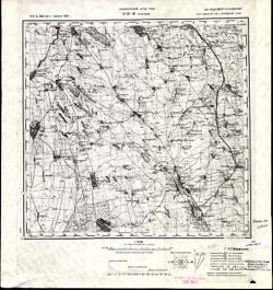
- Description:
- 1914
- Subject:
- Topical Subject: Maps, Topical Subject: Soviet Union, and Geographic Subject: Grosulovo
- Publisher:
- Генеральный штаб РККА
- Language:
- Russian
- Date Created:
- 1933
- Identifier:
- VAC9619-001532
- Genre:
- Military Maps and Topographic Maps
- Geographic Location:
- Coordinates: 47, 29.5, 47.3333, 30
- Related URL:
- DataCORE Dataset Download: https://datacore.iu.edu/concern/data_sets/s4655h48h
- Abstract:
- Modern area represented: Grosulovo, Odessa oblast, Ukraine
- Call Number:
- G7000 s100 .S7 sheet L-35-36
- Caption:
- Не подлежит оглашению
- City:
- Гросулово (Grosulovo)
- Copyright Holder:
- No Copyright - United States
- State/Province:
- Молдавская АССР (Moldavian Autonomous Soviet Socialist Republic), Украинская ССР (Ukrainian Soviet Socialist Republic), and Одесская область (Odessa oblast)
- Physical Description:
- Scale: 1:100,000
- Persistent URL:
- http://purl.dlib.indiana.edu/iudl/images/VAC9619/VAC9619-001532
- Provenance:
- CIA Map Library, Atlasblatt
-
- Description:
- 1874
- Subject:
- Topical Subject: Soviet Union, Geographic Subject: Hryhoriopol, and Topical Subject: Maps
- Publisher:
- Генеральный штаб РККА
- Language:
- Russian
- Date Created:
- 1916
- Identifier:
- VAC9619-001531
- Genre:
- Military Maps and Topographic Maps
- Geographic Location:
- Coordinates: 47, 29, 47.3333, 29.5
- Related URL:
- DataCORE Dataset Download: https://datacore.iu.edu/concern/data_sets/37720d55n
- Abstract:
- Modern area represented: Hryhoriopol, Stînga Nistrului, Moldova
- Call Number:
- G7000 s100 .S7 sheet L-35-35
- Caption:
- Не подлежит оглашению
- City:
- Григориополь (Hryhoriopol)
- Copyright Holder:
- No Copyright - United States
- State/Province:
- Бессарабия (Bessarabia), Молдавская АССР (Moldavian Autonomous Soviet Socialist Republic), and Украинская ССР (Ukrainian Soviet Socialist Republic)
- Physical Description:
- Scale: 1:100,000
- Persistent URL:
- http://purl.dlib.indiana.edu/iudl/images/VAC9619/VAC9619-001531
- Provenance:
- DMA Topographic Center, Army Map Service Library, Library of Congress Geography & Map Division
-
- Description:
- 1874
- Subject:
- Geographic Subject: Chisinau, Topical Subject: Maps, and Topical Subject: Soviet Union
- Publisher:
- Генеральный штаб РККА
- Language:
- Russian
- Date Created:
- 1916
- Identifier:
- VAC9619-001530
- Genre:
- Military Maps and Topographic Maps
- Geographic Location:
- Coordinates: 47, 28.5, 47.3333, 29
- Related URL:
- DataCORE Dataset Download: https://datacore.iu.edu/concern/data_sets/ns064674s
- Abstract:
- Modern area represented: Chisinau, Chișinău municipality, Moldova
- Call Number:
- G7000 s100 .S7 sheet L-35-34
- City:
- Кишинев (Kischinew)
- Copyright Holder:
- No Copyright - United States
- State/Province:
- Бессарабия (Bessarabia)
- Physical Description:
- Scale: 1:100,000
- Persistent URL:
- http://purl.dlib.indiana.edu/iudl/images/VAC9619/VAC9619-001530
- Provenance:
- DMA Topographic Center, Army Map Service Library, OMAHA, Library of Congress Geography & Map Division, Reichsamt für Landesaufnahme, Kartensammlung
-
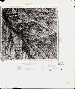
- Description:
- 1873
- Subject:
- Topical Subject: Soviet Union, Topical Subject: Maps, and Geographic Subject: Călărasi-Targ
- Publisher:
- Генеральный штаб РККА
- Language:
- Russian
- Date Created:
- 1940
- Identifier:
- VAC9619-001529
- Genre:
- Topographic Maps and Military Maps
- Geographic Location:
- Coordinates: 47, 28, 47.3333, 28.5
- Related URL:
- DataCORE Dataset Download: https://datacore.iu.edu/concern/data_sets/k3569497m
- Abstract:
- Modern area represented: Călărasi-Targ, Călăraşi county, Moldova
- Call Number:
- G7000 s100 .S7 sheet L-35-33
- City:
- Калараш-Тырг (Călărasi-Targ)
- Copyright Holder:
- No Copyright - United States
- Country:
- Румыния (Romania)
- State/Province:
- Бессарабия (Bessarabia)
- Physical Description:
- Scale: 1:100,000
- Persistent URL:
- http://purl.dlib.indiana.edu/iudl/images/VAC9619/VAC9619-001529
- Provenance:
- CIA Map Library
-
- Description:
- 1928
- Subject:
- Geographic Subject: Prisno, Topical Subject: Soviet Union, and Topical Subject: Maps
- Publisher:
- Управление военных топографов
- Language:
- Russian
- Identifier:
- VAC9619-001528
- Genre:
- Topographic Maps and Military Maps
- Geographic Location:
- Coordinates: 52.6667, 30.75, 53, 31
- Related URL:
- DataCORE Dataset Download: https://datacore.iu.edu/concern/data_sets/t722h949p
- Abstract:
- Modern area represented: Prisno, Homyel oblast, Belarus
- Call Number:
- G7000 s50 .S68 sheet N-36-110-D
- Caption:
- Не подлежит оглашению
- City:
- Присно (Prisno)
- Copyright Holder:
- No Copyright - United States
- Country:
- СССР (USSR)
- State/Province:
- Белорусская ССР (Byelorussian Soviet Socialist Republic)
- Physical Description:
- Scale: 1:50,000
- Persistent URL:
- http://purl.dlib.indiana.edu/iudl/images/VAC9619/VAC9619-001528
- Provenance:
- DMA Topographic Center, Army Map Service Library, OMAHA, Library of Congress Geography & Map Division
-
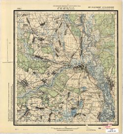
- Description:
- 1928
- Subject:
- Geographic Subject: Chachersk, Topical Subject: Soviet Union, and Topical Subject: Maps
- Publisher:
- Управление военных топографов РККА
- Language:
- Russian
- Identifier:
- VAC9619-001527
- Genre:
- Military Maps and Topographic Maps
- Geographic Location:
- Coordinates: 52.8667, 30.75, 53, 31
- Related URL:
- DataCORE Dataset Download: https://datacore.iu.edu/concern/data_sets/zg64tm62z
- Abstract:
- Modern area represented: Chachersk, Homyel oblast, Belarus
- Call Number:
- G7000 s50 .S68 sheet N-36-110-B
- Caption:
- Не подлежит оглашению
- City:
- Чечерск (Chachersk)
- Copyright Holder:
- No Copyright - United States
- Country:
- СССР (USSR)
- State/Province:
- Белорусская ССР (Byelorussian Soviet Socialist Republic)
- Physical Description:
- Scale: 1:50,000
- Persistent URL:
- http://purl.dlib.indiana.edu/iudl/images/VAC9619/VAC9619-001527
- Provenance:
- CIA Map Branch -- Received
-
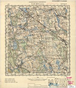
- Description:
- 1936
- Subject:
- Topical Subject: Maps, Topical Subject: Soviet Union, and Geographic Subject: Pirevichi
- Publisher:
- Управление военных топографов РККА
- Language:
- Russian
- Identifier:
- VAC9619-001526
- Genre:
- Military Maps and Topographic Maps
- Geographic Location:
- Coordinates: 52.6667, 30.25, 52.8667, 30.5
- Related URL:
- DataCORE Dataset Download: https://datacore.iu.edu/concern/data_sets/ws859g42z
- Abstract:
- Modern area represented: Pirevichi, Homyel oblast, Belarus
- Call Number:
- G7000 s50 .S68 sheet N-36-109-D
- Caption:
- Не подлежит оглашению
- City:
- Пиревичи (Pirevichi)
- Copyright Holder:
- No Copyright - United States
- Country:
- СССР (USSR)
- State/Province:
- Белорусская ССР (Byelorussian Soviet Socialist Republic)
- Physical Description:
- Scale: 1:50,000
- Persistent URL:
- http://purl.dlib.indiana.edu/iudl/images/VAC9619/VAC9619-001526
- Provenance:
- M. I. Map Library, G000-30, Atlasblatt
-
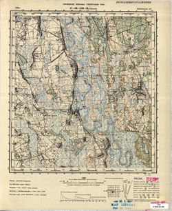
- Description:
- 1936
- Subject:
- Topical Subject: Maps, Topical Subject: Soviet Union, and Geographic Subject: Streshin
- Publisher:
- Управление военных топографов РККА
- Language:
- Russian
- Identifier:
- VAC9619-001525
- Genre:
- Military Maps and Topographic Maps
- Geographic Location:
- Coordinates: 52.6667, 30, 52.8667, 30.25
- Related URL:
- DataCORE Dataset Download: https://datacore.iu.edu/concern/data_sets/m039k5713
- Abstract:
- Modern area represented: Streshin, Homyel oblast, Belarus
- Call Number:
- G7000 s50 .S68 sheet N-36-109-В
- Caption:
- Не подлежит оглашению
- City:
- Стрешин (Streshin)
- Copyright Holder:
- No Copyright - United States
- Country:
- СССР (USSR)
- State/Province:
- Белорусская ССР (Byelorussian Soviet Socialist Republic)
- Physical Description:
- Scale: 1:50,000
- Persistent URL:
- http://purl.dlib.indiana.edu/iudl/images/VAC9619/VAC9619-001525
- Provenance:
- M. I. Map Library, G000-30, GS, RA
-
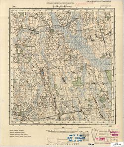
- Description:
- 1936
- Subject:
- Geographic Subject: Haradzyets, Topical Subject: Maps, and Topical Subject: Soviet Union
- Publisher:
- Управление военных топографов РККА
- Language:
- Russian
- Identifier:
- VAC9619-001524
- Genre:
- Military Maps and Topographic Maps
- Geographic Location:
- Coordinates: 52.8667, 30.25, 53, 30.5
- Related URL:
- DataCORE Dataset Download: https://datacore.iu.edu/concern/data_sets/4m90dw37d
- Abstract:
- Modern area represented: Haradzyets, Homyel oblast, Belarus
- Call Number:
- G7000 s50 .S68 sheet N-36-109-B
- Caption:
- Не подлежит оглашению
- City:
- Городец (Haradzyets)
- Copyright Holder:
- No Copyright - United States
- Country:
- СССР (USSR)
- State/Province:
- Белорусская ССР (Byelorussian Soviet Socialist Republic)
- Physical Description:
- Scale: 1:50,000
- Persistent URL:
- http://purl.dlib.indiana.edu/iudl/images/VAC9619/VAC9619-001524
- Provenance:
- M. I. Map Library, Atlasblatt
-
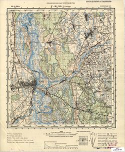
- Description:
- 1931
- Subject:
- Geographic Subject: Zhlobin, Topical Subject: Soviet Union, and Topical Subject: Maps
- Publisher:
- Управление военных топографов РККА
- Language:
- Russian
- Date Created:
- 1936
- Identifier:
- VAC9619-001523
- Genre:
- Topographic Maps and Military Maps
- Geographic Location:
- Coordinates: 52.8667, 30, 53, 30.25
- Related URL:
- DataCORE Dataset Download: https://datacore.iu.edu/concern/data_sets/tx31qj33m
- Abstract:
- Modern area represented: Zhlobin, Homyel oblast, Belarus
- Call Number:
- G7000 s50 .S68 sheet N-36-109-A
- Caption:
- Не подлежит оглашению
- City:
- Жлобин (Zhlobin)
- Copyright Holder:
- No Copyright - United States
- Country:
- СССР (USSR)
- State/Province:
- Белорусская ССР (Byelorussian Soviet Socialist Republic)
- Physical Description:
- Scale: 1:50,000
- Persistent URL:
- http://purl.dlib.indiana.edu/iudl/images/VAC9619/VAC9619-001523
- Provenance:
- CIA Map Branch -- Received
-
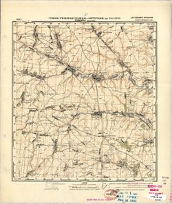
- Description:
- 1940
- Subject:
- Geographic Subject: Maslovo, Topical Subject: Soviet Union, and Topical Subject: Maps
- Publisher:
- Главное Управление Геодезии и Картографии при СНК СССР
- Language:
- Russian
- Date Created:
- 1941
- Identifier:
- VAC9619-001522
- Genre:
- Topographic Maps and Military Maps
- Geographic Location:
- Coordinates: 53, 35.75, 53.1667, 36
- Related URL:
- DataCORE Dataset Download: https://datacore.iu.edu/concern/data_sets/hh63sw60c
- Abstract:
- Modern area represented: Maslovo, Oryol oblast, Russia
- Call Number:
- G7000 s50 .S68 sheet N-36-108-D
- Caption:
- Для служебного пользования
- City:
- Маслово (Maslovo)
- Copyright Holder:
- No Copyright - United States
- Country:
- СССР (USSR)
- State/Province:
- РСФСР (RSFSR) and Орловская область (Oryol oblast)
- Physical Description:
- Scale: 1:50,000
- Persistent URL:
- http://purl.dlib.indiana.edu/iudl/images/VAC9619/VAC9619-001522
- Provenance:
- M. I. Map Library, Library of Congress Geography & Map Division
-
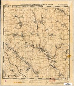
- Description:
- 1940
- Subject:
- Geographic Subject: Paramonovo, Topical Subject: Maps, and Topical Subject: Soviet Union
- Publisher:
- Главное Управление Геодезии и Картографии при СНК СССР
- Language:
- Russian
- Date Created:
- 1941
- Identifier:
- VAC9619-001521
- Genre:
- Military Maps and Topographic Maps
- Geographic Location:
- Coordinates: 53, 35.5, 53.1667, 35.75
- Related URL:
- DataCORE Dataset Download: https://datacore.iu.edu/concern/data_sets/ww72bc29n
- Abstract:
- Modern area represented: Paramonovo, Oryol oblast, Russia
- Call Number:
- G7000 s50 .S68 sheet N-36-108-C
- Caption:
- Для служебного пользования
- City:
- Парамоново (Paramonovo)
- Copyright Holder:
- No Copyright - United States
- Country:
- СССР (USSR)
- State/Province:
- Орловская область (Oryol oblast) and РСФСР (RSFSR)
- Physical Description:
- Scale: 1:50,000
- Persistent URL:
- http://purl.dlib.indiana.edu/iudl/images/VAC9619/VAC9619-001521
- Provenance:
- Library of Congress Geography & Map Division
