
Search Constraints
You searched for:
Campus
IUB
Remove constraint Campus: IUB
Holding Location
B-WELLS
Remove constraint Holding Location: B-WELLS
Search Results
-
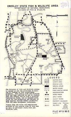
- Subject:
- Topical Subject: Wildlife conservation--Law and legislation, Geographic Subject: North Vernon (Ind.), Topical Subject: Wildlife management areas, Topical Sub...
- Creator:
- Indiana. Division of Fish and Wildlife
- Publisher:
- Indiana. Division of Fish and Wildlife
- Date Created:
- 1971
- Identifier:
- VAC3073-M-01265
- Genre:
- Thematic maps
- Geographic Location:
- Coordinates: W0853748 W0853424 N0385849 N0385555
- Related URL:
- Catalog URL: https://iucat.iu.edu/catalog/18388142
- Abstract:
- Shows hunting area, shooting and archery ranges, parking lots, lakes and ponds, headquarters, roads, boundaries, powerlines, and railroads. Rules and regulat...
- Call Number:
- G4091.E63 svar .I5 Crosley
- Caption:
- Imprint: [Indianapolis?] : [The Division], 1971.
- Physical Description:
- Scale: Scale approximately 1:24,000 and Dimensions: 36 x 22 cm or smaller
- Alternate Identifier:
- Title Control Number: a18388142
- Persistent URL:
- https://purl.dlib.indiana.edu/iudl/images/VAC3073/VAC3073-M-01265
- Provenance:
- Indiana state fish and wildlife areas. Department of Natural Resources. Division of Fish and Wildlife. [Indianapolis?] : The Division, 1971-.
-
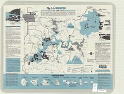
- Subject:
- Geographic Subject: Monroe, Lake (Ind.), Topical Subject: Lakes, and Topical Subject: Reservoirs
- Creator:
- Guide Art Co.
- Publisher:
- [publisher not identified]
- Date Created:
- 1971
- Identifier:
- VAC3073-M-00207
- Genre:
- Tourist maps and Pictorial maps
- Geographic Location:
- Coordinates: W0863238 W0861207 N0391240 N0385806
- Related URL:
- Catalog URL: https://iucat.iu.edu/catalog/5301880
- Abstract:
- Folded title: Tourist guide to Lake Monroe, Indiana's largest lake. Includes text, recreation information, and 9 recreation area maps. Advertisements...
- Call Number:
- G4092.M6E635 1971 .G8
- Caption:
- Imprint: Bloomington, Ind. : [publisher not identified], [1971]
- Physical Description:
- Dimensions: 43 x 56 cm and Scale: 1:80,000
- Alternate Identifier:
- Title Control Number: a5301880
- Persistent URL:
- https://purl.dlib.indiana.edu/iudl/images/VAC3073/VAC3073-M-00207
-
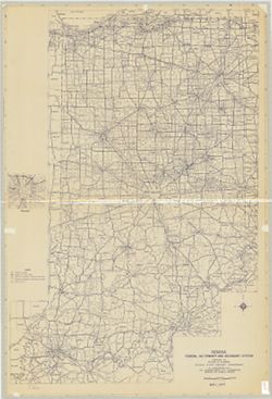
- Subject:
- Topical Subject: Roads and Geographic Subject: Indiana
- Creator:
- Indiana. State Highway Commission (1961-1981). Division of Planning
- Publisher:
- Indiana. State Highway Commission (1961-1981). Division of Planning
- Date Created:
- 1971
- Identifier:
- VAC3073-M-00638
- Genre:
- Road maps
- Geographic Location:
- Coordinates: W0880700 W0844500 N0414500 N0375200
- Related URL:
- Catalog URL: https://iucat.iu.edu/catalog/5335907
- Abstract:
- Blue line print. "May 1, 1971." Includes inset of Indianapolis.
- Call Number:
- G4091.P2 1971 .I53
- Caption:
- Imprint: [Indianapolis?] : [The Division?], [1971?]
- Physical Description:
- Dimensions: 133 x 89 cm and Scale: 1:360,000
- Alternate Identifier:
- Title Control Number: a5335907
- Persistent URL:
- https://purl.dlib.indiana.edu/iudl/images/VAC3073/VAC3073-M-00638
-
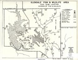
- Subject:
- Topical Subject: Lakes, Topical Subject: Blinds (Hunting), Topical Subject: Waterfowl shooting--Law and legislation, Geographic Subject: Glendale State Fish ...
- Creator:
- Indiana. Division of Fish and Wildlife
- Publisher:
- Indiana. Division of Fish and Wildlife
- Date Created:
- 1971
- Identifier:
- VAC3073-M-01266
- Genre:
- Thematic maps
- Geographic Location:
- Coordinates: W0870435 W0870026 N0383459 N0383104
- Related URL:
- Catalog URL: https://iucat.iu.edu/catalog/18388176
- Abstract:
- Title on verso: Migratory waterfowl rules and regulations : Glendale state fish and wildlife area. Shows duck blinds, check stations, roads, water areas, and...
- Call Number:
- G4091.E63 svar .I5 Glendale 2
- Caption:
- Imprint: [Indianapolis?] : The Division, 1971.
- Physical Description:
- Scale: Scale not given. and Dimensions: 36 x 22 cm or smaller
- Alternate Identifier:
- Title Control Number: a18388176
- Persistent URL:
- https://purl.dlib.indiana.edu/iudl/images/VAC3073/VAC3073-M-01266
- Provenance:
- Indiana state fish and wildlife areas. Department of Natural Resources. Division of Fish and Wildlife. [Indianapolis?] : The Division, 1971-.
-
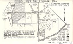
- Subject:
- Topical Subject: Game laws, Topical Subject: Wildlife management areas, Geographic Subject: Kingsbury State Fish and Wildlife Area (Ind.), and Geographic Sub...
- Creator:
- Indiana. Division of Fish and Wildlife
- Publisher:
- Indiana. Division of Fish and Wildlife
- Date Created:
- 1971
- Identifier:
- VAC3073-M-01273
- Genre:
- Thematic maps
- Geographic Location:
- Coordinates: W0863755 W0863230 N0413154 N0412922
- Related URL:
- Catalog URL: https://iucat.iu.edu/catalog/18405975
- Abstract:
- Title on verso: Rules and regulations : Kingsbury State Fish and Wildlife Area. Shows marshes, railroads, parking lots, roads, water and hunting areas, headq...
- Call Number:
- G4091.E63 svar .I5 Kingsbury
- Caption:
- Imprint: [Indianapolis?] : [The Division], 1971.
- Physical Description:
- Dimensions: 36 x 22 cm or smaller and Scale: Approximately 1:24,000
- Alternate Identifier:
- Title Control Number: a18405975
- Persistent URL:
- https://purl.dlib.indiana.edu/iudl/images/VAC3073/VAC3073-M-01273
- Provenance:
- Indiana state fish and wildlife areas. Department of Natural Resources. Division of Fish and Wildlife. [Indianapolis?] : The Division, 1971-.
-
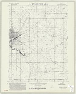
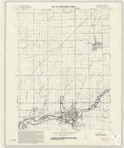
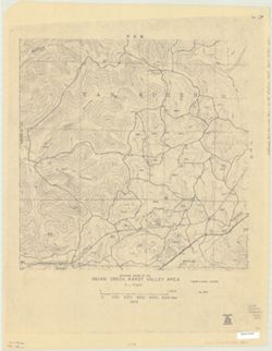
- Subject:
- Geographic Subject: Hartford City Region (Ind.), Topical Subject: Floods, Geographic Subject: Blackford County (Ind.), Topical Subject: Flood forecasting, an...
- Creator:
- Geological Survey (U.S.)
- Publisher:
- Geological Survey (U.S.)
- Date Created:
- 1971
- Identifier:
- VAC3073-M-00895
- Genre:
- Topographic maps, Quadrangle maps, and 7.5 minute topographic maps
- Geographic Location:
- Coordinates: W0852230 W0851500 N0403000 N0402230
- Related URL:
- Catalog URL: https://iucat.iu.edu/catalog/18416323
- Abstract:
- Filing title: Hartford City East, Ind. Relief shown by contours and spot heights. Contour interval 10 feet. Includes quadrangle location map. Shows portion o...
- Call Number:
- G4091.C32 s24 .G4 Hartford City East, In
- Caption:
- Imprint: Washington, D.C. : Interior--Geological Survey, [1971]
- Physical Description:
- Dimensions: 59 x 45 or smaller and Scale: 1:24,000
- Alternate Identifier:
- Title Control Number: a18416323 and Alternate ID: CAW5372BB
- Persistent URL:
- https://purl.dlib.indiana.edu/iudl/images/VAC3073/VAC3073-M-00895
- Provenance:
- United States Department of the Interior, Geological Survey. Map of flood-prone areas : [Indiana]. Washington, D.C. : The Survey, 1969-.
-
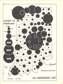
- Subject:
- Topical Subject: Labor supply, Topical Subject: Business enterprises--Employees, and Geographic Subject: Indiana
- Creator:
- Hollingsworth, John M. and Kingsbury, Robert C.
- Publisher:
- Indiana University. Department of Geography
- Date Created:
- 1970
- Identifier:
- VAC3073-M-00226
- Genre:
- Thematic maps
- Geographic Location:
- Coordinates: W0880700 W0844500 N0414500 N0374600
- Related URL:
- Catalog URL: https://iucat.iu.edu/catalog/15948581
- Abstract:
- Graduated symbol map. Shows number of employees by county. Detached from: An atlas of Indiana / by Robert C. Kingsbury , with contributions from John M. H...
- Call Number:
- G4091.G8 1967 .K56
- Caption:
- Imprint: Bloomington, Indiana : Department of Geography, Indiana University, [1970]
- Physical Description:
- Dimensions: 26 x 18 cm, on sheet 28 x 21 cm and Scale: Approximately 1:1,950,000
- Alternate Identifier:
- Alternate ID: 317383IP and Title Control Number: a15948581
- Persistent URL:
- https://purl.dlib.indiana.edu/iudl/images/VAC3073/VAC3073-M-00226
- Provenance:
- An atlas of Indiana / by Robert C. Kingsbury [1970].
-
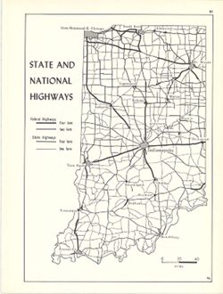
- Subject:
- Geographic Subject: Indiana and Topical Subject: Roads
- Creator:
- Hollingsworth, John M. and Kingsbury, Robert C.
- Publisher:
- Indiana University. Department of Geography
- Date Created:
- 1970
- Identifier:
- VAC3073-M-00815
- Genre:
- Road maps
- Geographic Location:
- Coordinates: W0880700 W0844500 N0414500 N0374600
- Related URL:
- Catalog URL: https://iucat.iu.edu/catalog/15938064
- Abstract:
- Shows two lane and four lane federal highways and two lane and four lane state highways. Detached from: An atlas of Indiana / by Robert C. Kingsbury , wit...
- Call Number:
- G4091.P2 1970 .K56
- Caption:
- Imprint: Bloomington, Indiana : Department of Geography, Indiana University, [1970]
- Physical Description:
- Scale: Approximately 1:2,000,000 and Dimensions: 26 x 18 cm, on sheet 28 x 21 cm
- Alternate Identifier:
- Alternate ID: 317383IP and Title Control Number: a15938064
- Persistent URL:
- https://purl.dlib.indiana.edu/iudl/images/VAC3073/VAC3073-M-00815
- Provenance:
- An atlas of Indiana / by Robert C. Kingsbury [1970].
-
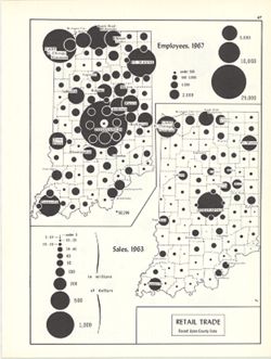
- Subject:
- Topical Subject: Retail trade--Employees, Geographic Subject: Indiana, and Topical Subject: Labor supply
- Creator:
- Hollingsworth, John M. and Kingsbury, Robert C.
- Publisher:
- Indiana University. Department of Geography
- Date Created:
- 1970
- Identifier:
- VAC3073-M-00179
- Genre:
- Thematic maps
- Geographic Location:
- Coordinates: W0880700 W0844500 N0414500 N0374600
- Related URL:
- Catalog URL: https://iucat.iu.edu/catalog/15987122
- Abstract:
- 2 maps on 1 sheet, Retail trade employees, 1967, and Retail trade sales, 1963. Graduated symbol map. Detached from: An atlas of Indiana / by Robert C. Kin...
- Call Number:
- G4091.G8 1963 .K57
- Caption:
- Imprint: Bloomington, Indiana : Department of Geography, Indiana University, [1970]
- Physical Description:
- Dimensions: on sheet 28 x 21 cm and Scale: Approximately 1:2,700,000
- Alternate Identifier:
- Alternate ID: 317383IP and Title Control Number: a15987122
- Persistent URL:
- https://purl.dlib.indiana.edu/iudl/images/VAC3073/VAC3073-M-00179
- Provenance:
- An atlas of Indiana / by Robert C. Kingsbury [1970].
-
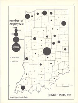
- Subject:
- Topical Subject: Service industries workers, Geographic Subject: Indiana, and Topical Subject: Labor supply
- Creator:
- Hollingsworth, John M. and Kingsbury, Robert C.
- Publisher:
- Indiana University. Department of Geography
- Date Created:
- 1970
- Identifier:
- VAC3073-M-00224
- Genre:
- Thematic maps
- Geographic Location:
- Coordinates: W0880700 W0844500 N0414500 N0374600
- Related URL:
- Catalog URL: https://iucat.iu.edu/catalog/15950444
- Abstract:
- Graduated symbol map. Shows number of employees by county. Detached from: An atlas of Indiana / by Robert C. Kingsbury , with contributions from John M. H...
- Call Number:
- G4091.G8 1967 .K57
- Caption:
- Imprint: Bloomington, Indiana : Department of Geography, Indiana University, [1970]
- Physical Description:
- Dimensions: 26 x 18 cm, on sheet 28 x 21 cm and Scale: Approximately 1:1,950,000
- Alternate Identifier:
- Alternate ID: 317383IP and Title Control Number: a15950444
- Persistent URL:
- https://purl.dlib.indiana.edu/iudl/images/VAC3073/VAC3073-M-00224
- Provenance:
- An atlas of Indiana / by Robert C. Kingsbury [1970].
-
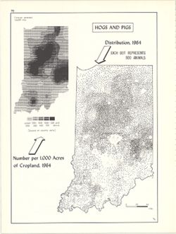
- Subject:
- Geographic Subject: Indiana, Topical Subject: Swine--Geographical distribution, and Topical Subject: SYMAP (Computer program language)
- Creator:
- Hollingsworth, John M., Kingsbury, Robert C., and Indiana University. Research Computing Center
- Publisher:
- Indiana University. Department of Geography
- Date Created:
- 1970
- Identifier:
- VAC3073-M-00632
- Genre:
- Thematic maps
- Geographic Location:
- Coordinates: W0880700 W0844500 N0414500 N0374600
- Related URL:
- Catalog URL: https://iucat.iu.edu/catalog/15984668
- Abstract:
- Dot distribution map. Includes ancillary computer generated isopleth map Hogs and pigs: number per 1,000 acres of cropland, 1964. ASCII-art map created using...
- Call Number:
- G4091.J5 1964 .K57
- Caption:
- Imprint: Bloomington, Indiana : Department of Geography, Indiana University, [1970]
- Physical Description:
- Dimensions: 26 x 18 cm, on sheet 28 x 21 cm and Scale: Approximately 1:2,534,400
- Alternate Identifier:
- Title Control Number: a15984668 and Alternate ID: 317383IP
- Persistent URL:
- https://purl.dlib.indiana.edu/iudl/images/VAC3073/VAC3073-M-00632
- Provenance:
- An atlas of Indiana / by Robert C. Kingsbury [1970].
-
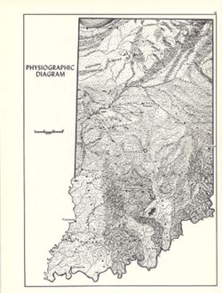
- Subject:
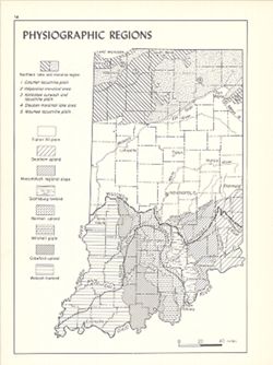
- Geographic Subject: Indiana, Topical Subject: Physiographic provinces, and Topical Subject: Physical geography
- Creator:
- Switzer, J. E. (Jesse Elmer) and Kingsbury, Robert C.
- Publisher:
- Indiana University. Department of Geography
- Date Created:
- 1970
- Identifier:
- VAC3073-M-00819
- Genre:
- Physical maps and Topographic maps
- Geographic Location:
- Coordinates: W0880700 W0844500 N0414500 N0374600
- Related URL:
- Catalog URL: https://iucat.iu.edu/catalog/15938799
- Abstract:
- Relief shown by landform drawing. Shows southern limit of glaciation in Indiana. Originally compiled approximately 1932 by J.E. Switzer, Department of Geolog...
- Call Number:
- G4091.C21 1970 .S96
- Caption:
- Imprint: Bloomington, Indiana : Department of Geography, Indiana University, [1970]
- Physical Description:
- Dimensions: 26 x 18 cm, on sheet 28 x 21 cm and Scale: Approximately 1:1,850,000
- Alternate Identifier:
- Alternate ID: 317383IP and Title Control Number: a15938799
- Persistent URL:
- https://purl.dlib.indiana.edu/iudl/images/VAC3073/VAC3073-M-00819
- Provenance:
- An atlas of Indiana / by Robert C. Kingsbury [1970].
-
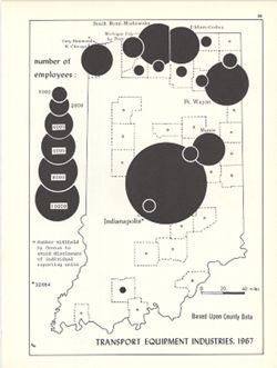
- Subject:
- Topical Subject: Labor supply, Topical Subject: Transportation equipment industry--Employees, and Geographic Subject: Indiana
- Creator:
- Kingsbury, Robert C. and Hollingsworth, John M.
- Publisher:
- Indiana University. Department of Geography
- Date Created:
- 1970
- Identifier:
- VAC3073-M-00620
- Genre:
- Thematic maps
- Geographic Location:
- Coordinates: W0880700 W0844500 N0414500 N0374600
- Related URL:
- Catalog URL: https://iucat.iu.edu/catalog/15951296
- Abstract:
- Graduated symbol map. Shows number of employees by county. Detached from: An atlas of Indiana / by Robert C. Kingsbury , with contributions from John M. H...
- Call Number:
- G4091.G8 1967 .K62
- Caption:
- Imprint: Bloomington, Indiana : Department of Geography, Indiana University, [1970]
- Physical Description:
- Dimensions: 26 x 18 cm, on sheet 28 x 21 cm and Scale: Approximately 1:1,950,000
- Alternate Identifier:
- Alternate ID: 317383IP and Title Control Number: a15951296
- Persistent URL:
- https://purl.dlib.indiana.edu/iudl/images/VAC3073/VAC3073-M-00620
- Provenance:
- An atlas of Indiana / by Robert C. Kingsbury [1970].
-
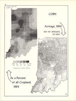
- Subject:
- Topical Subject: SYMAP (Computer program language), Topical Subject: Corn--Geographical distribution, Geographic Subject: Indiana, and Topical Subject: Phyto...
- Creator:
- Hollingsworth, John M., Indiana University. Research Computing Center, and Kingsbury, Robert C.
- Publisher:
- Indiana University. Department of Geography
- Date Created:
- 1970
- Identifier:
- VAC3073-M-00267
- Genre:
- Thematic maps
- Geographic Location:
- Coordinates: W0880700 W0844500 N0414500 N0374600
- Related URL:
- Catalog URL: https://iucat.iu.edu/catalog/15984676
- Abstract:
- Dot distribution map. Includes ancillary computer generated isopleth map Corn as a percent of all cropland, 1964. ASCII-art map created using SYMAP or simila...
- Call Number:
- G4091.J7 1964 .K56
- Caption:
- Imprint: Bloomington, Indiana : Department of Geography, Indiana University, [1970]
- Physical Description:
- Scale: Approximately 1:2,534,400 and Dimensions: 26 x 18 cm, on sheet 28 x 21 cm
- Alternate Identifier:
- Title Control Number: a15984676 and Alternate ID: 317383IP
- Persistent URL:
- https://purl.dlib.indiana.edu/iudl/images/VAC3073/VAC3073-M-00267
- Provenance:
- An atlas of Indiana / by Robert C. Kingsbury [1970].
-
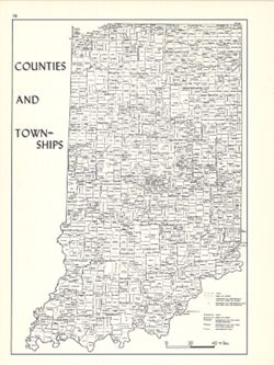
- Subject:
- Geographic Subject: Indiana, Topical Subject: Administrative and political divisions, and Topical Subject: Counties
- Creator:
- Kingsbury, Robert C. and Hollingsworth, John M.
- Publisher:
- Indiana University. Department of Geography
- Date Created:
- 1970
- Identifier:
- VAC3073-M-00412
- Genre:
- Thematic maps
- Geographic Location:
- Coordinates: W0880700 W0844500 N0414500 N0374600
- Related URL:
- Catalog URL: https://iucat.iu.edu/catalog/15942420
- Abstract:
- Shows locations of Indiana counties and townships. Detached from: An atlas of Indiana / by Robert C. Kingsbury , with contributions from John M. Hollings...
- Call Number:
- G4091.F7 1970 .K56
- Caption:
- Imprint: Bloomington, Indiana : Department of Geography, Indiana University, [1970]
- Physical Description:
- Scale: Approximately 1:1,800,000 and Dimensions: 26 x 18 cm, on sheet 28 x 21 cm
- Alternate Identifier:
- Title Control Number: a15942420 and Alternate ID: 317383IP
- Persistent URL:
- https://purl.dlib.indiana.edu/iudl/images/VAC3073/VAC3073-M-00412
- Provenance:
- An atlas of Indiana / by Robert C. Kingsbury [1970].
-
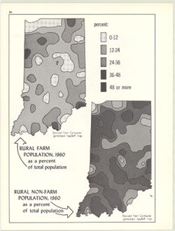
- Subject:
- Topical Subject: Rural population and Geographic Subject: Indiana
- Creator:
- Kingsbury, Robert C. and Indiana University. Research Computing Center
- Publisher:
- Indiana University. Department of Geography
- Date Created:
- 1970
- Identifier:
- VAC3073-M-00050
- Genre:
- Thematic maps
- Geographic Location:
- Coordinates: W0880700 W0844500 N0414500 N0374600
- Related URL:
- Catalog URL: https://iucat.iu.edu/catalog/15948031
- Abstract:
- 2 maps on 1 sheet, Rural farm population, 1960, as a percent of total population and Rural non-farm population, 1960, as a percent of total population. Compu...
- Call Number:
- G4091.E2 1960 .K59
- Caption:
- Imprint: Bloomington, Indiana : Department of Geography, Indiana University, [1970]
- Physical Description:
- Dimensions: on sheet 28 x 21 cm and Scale: Approximately 1:3,000,000
- Alternate Identifier:
- Title Control Number: a15948031 and Alternate ID: 317383IP
- Persistent URL:
- https://purl.dlib.indiana.edu/iudl/images/VAC3073/VAC3073-M-00050
- Provenance:
- An atlas of Indiana / by Robert C. Kingsbury [1970].
-
- Subject:
- Topical Subject: SYMAP (Computer program language), Topical Subject: Agricultural resources, Geographic Subject: Indiana, and Topical Subject: Land capabilit...
- Creator:
- Hollingsworth, John M., Kingsbury, Robert C., and Indiana University. Research Computing Center
- Publisher:
- Indiana University. Department of Geography
- Date Created:
- 1970
- Identifier:
- VAC3073-M-00052
- Genre:
- Thematic maps
- Geographic Location:
- Coordinates: W0880700 W0844500 N0414500 N0374600
- Related URL:
- Catalog URL: https://iucat.iu.edu/catalog/15995410
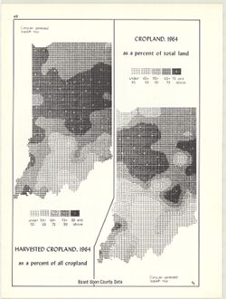
- Abstract:
- 2 maps on 1 sheet, Cropland, 1964, as a percent of total land and Harvested cropland, 1964, as a percent of total land. Computer generated isopleth maps obta...
- Call Number:
- G4091.J1 1964 .K56
- Caption:
- Imprint: Bloomington, Indiana : Department of Geography, Indiana University, [1970]
- Physical Description:
- Dimensions: each 26 x 10 cm, on sheet 28 x 21 cm and Scale: Approximately 1:3,000,000
- Alternate Identifier:
- Alternate ID: 317383IP and Title Control Number: a15995410
- Persistent URL:
- https://purl.dlib.indiana.edu/iudl/images/VAC3073/VAC3073-M-00052
- Provenance:
- An atlas of Indiana / by Robert C. Kingsbury [1970].
-
- Subject:
- Topical Subject: Wholesale trade, Topical Subject: Labor supply, and Geographic Subject: Indiana
- Creator:
- Hollingsworth, John M. and Kingsbury, Robert C.
- Publisher:
- Indiana University. Department of Geography
- Date Created:
- 1970
- Identifier:
- VAC3073-M-00715
- Genre:
- Thematic maps
- Geographic Location:
- Coordinates: W0880700 W0844500 N0414500 N0374600
- Related URL:
- Catalog URL: https://iucat.iu.edu/catalog/15987137
- Abstract:
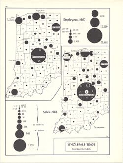
- 2 maps on 1 sheet, Wholesale trade, employees, 1967, and Wholesale trade sales, 1963. Graduated symbol maps. Detached from: An atlas of Indiana / by Rober...
- Call Number:
- G4091.G8 1963 .K58
- Caption:
- Imprint: Bloomington, Indiana : Department of Geography, Indiana University, [1970]
- Physical Description:
- Dimensions: on sheet 28 x 21 cm and Scale: Approximately 1:2,700,000
- Alternate Identifier:
- Title Control Number: a15987137 and Alternate ID: 317383IP
- Persistent URL:
- https://purl.dlib.indiana.edu/iudl/images/VAC3073/VAC3073-M-00715
- Provenance:
- An atlas of Indiana / by Robert C. Kingsbury [1970].
-
- Subject:
- Geographic Subject: Indiana and Topical Subject: Railroads--Passanger traffic
- Creator:
- Kingsbury, Robert C. and Hollingsworth, John M.
- Publisher:
- Indiana University. Department of Geography
- Date Created:
- 1970
- Identifier:
- VAC3073-M-00051
- Genre:
- Thematic maps
- Geographic Location:
- Coordinates: W0880700 W0844500 N0414500 N0374600
- Related URL:
- Catalog URL: https://iucat.iu.edu/catalog/15934583
- Abstract:
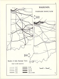
- 2 maps on 1 sheet. Shows number of daily passenger trains on Indiana railways in 1869 and 1969. Detached from: An atlas of Indiana / by Robert C. Kingsbur...
- Call Number:
- G4091.P3 1969 .K57
- Caption:
- Imprint: Bloomington, Indiana : Department of Geography, Indiana University, [1970]
- Physical Description:
- Scale: Approximately 1:2,880,000 and Dimensions: on sheet 28 x 21 cm
- Alternate Identifier:
- Alternate ID: 317383IP and Title Control Number: a15934583
- Persistent URL:
- https://purl.dlib.indiana.edu/iudl/images/VAC3073/VAC3073-M-00051
- Provenance:
- An atlas of Indiana / by Robert C. Kingsbury [1970].
-
- Subject:
- Topical Subject: SYMAP (Computer program language), Geographic Subject: Indiana, and Topical Subject: Cattle--Geographical distribution
- Creator:
- Hollingsworth, John M., Indiana University. Research Computing Center, and Kingsbury, Robert C.
- Publisher:
- Indiana University. Department of Geography
- Date Created:
- 1970
- Identifier:
- VAC3073-M-00066
- Genre:
- Thematic maps
- Geographic Location:
- Coordinates: W0880700 W0844500 N0414500 N0374600
- Related URL:
- Catalog URL: https://iucat.iu.edu/catalog/15736851
- Abstract:
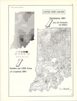
- Dot distribution map. Includes ancillary computer generated isopleth map Cattle and calves: number per 1,000 acres of cropland, 1964. ASCII-art map created u...
- Call Number:
- G4091.J5 1964 .K56
- Caption:
- Imprint: Bloomington, Indiana : Department of Geography, Indiana University, [1970]
- Physical Description:
- Scale: 1:2,534,400 and Dimensions: 26 x 18 cm
- Alternate Identifier:
- Alternate ID: 317383IP and Title Control Number: a15736851
- Persistent URL:
- https://purl.dlib.indiana.edu/iudl/images/VAC3073/VAC3073-M-00066
- Provenance:
- An atlas of Indiana / by Robert C. Kingsbury [1970].
-
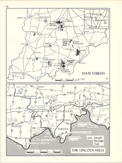
- Subject:
- Topical Subject: Forest reserves, Geographic Subject: Indiana, Geographic Subject: Lincoln Hills Resource Conservation and Development Project Area (Ind.), a...
- Creator:
- Hollingsworth, John M. and Kingsbury, Robert C.
- Publisher:
- Indiana University. Department of Geography
- Date Created:
- 1970
- Identifier:
- VAC3073-M-00668
- Genre:
- Tourist maps and Thematic maps
- Geographic Location:
- Coordinates: W0880610 W0844655 N0393200 N0374600
- Related URL:
- Catalog URL: https://iucat.iu.edu/catalog/15938315
- Abstract:
- 2 maps on 1 sheet, State Forests and The Lincoln Hills. Lincoln Hills map (1:690,000) shows Lincoln Heritage Trail, various Lincoln-related sites and other n...
- Call Number:
- G4091.K2 1970 .K56
- Caption:
- Imprint: Bloomington, Indiana : Department of Geography, Indiana University, [1970]
- Physical Description:
- Scale: Approximately 1:1,600,000 and Dimensions: each 13 x 18 cm, on sheet 28 x 21 cm
- Alternate Identifier:
- Alternate ID: 317383IP and Title Control Number: a15938315
- Persistent URL:
- https://purl.dlib.indiana.edu/iudl/images/VAC3073/VAC3073-M-00668
- Provenance:
- An atlas of Indiana / by Robert C. Kingsbury [1970].
-
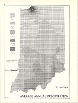
- Subject:
- Topical Subject: Rain and rainfall, Topical Subject: SYMAP (Computer program language), and Geographic Subject: Indiana
- Creator:
- Kingsbury, Robert C. and Indiana University. Research Computing Center
- Publisher:
- Indiana University. Department of Geography
- Date Created:
- 1970
- Identifier:
- VAC3073-M-00141
- Genre:
- Thematic maps
- Geographic Location:
- Coordinates: W0880700 W0844500 N0414500 N0374600
- Related URL:
- Catalog URL: https://iucat.iu.edu/catalog/15995731
- Abstract:
- Computer generated isometric map obtained through use of the facilities of Indiana University's Research Computer Center. ASCII-art map created using SYM...
- Call Number:
- G4091.C883 1970 .K56
- Caption:
- Imprint: Bloomington, Indiana : Department of Geography, Indiana University, [1970]
- Physical Description:
- Dimensions: 26 x 18 cm and Scale: Approximately 1:1,950,000
- Alternate Identifier:
- Title Control Number: a15995731 and Alternate ID: 317383IP
- Persistent URL:
- https://purl.dlib.indiana.edu/iudl/images/VAC3073/VAC3073-M-00141
- Provenance:
- An atlas of Indiana / by Robert C. Kingsbury [1970].
-
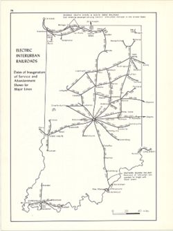
- Subject:
- Geographic Subject: Indiana and Topical Subject: Electric railroads
- Creator:
- Hollingsworth, John M. and Kingsbury, Robert C.
- Publisher:
- Indiana University. Department of Geography
- Date Created:
- 1970
- Identifier:
- VAC3073-M-00731
- Genre:
- Thematic maps
- Geographic Location:
- Coordinates: W0880700 W0844500 N0414500 N0374600
- Related URL:
- Catalog URL: https://iucat.iu.edu/catalog/15937442
- Abstract:
- Shows dates of inauguration of service and abandonment shown for major lines. Detached from: An atlas of Indiana / by Robert C. Kingsbury , with contribut...
- Call Number:
- G4091.P3 1970 .K57
- Caption:
- Imprint: Bloomington, Indiana : Department of Geography, Indiana University, [1970]
- Physical Description:
- Scale: Approximately 1:1,950,000 and Dimensions: 26 x 18 cm, on sheet 28 x 21 cm
- Alternate Identifier:
- Alternate ID: 317383IP and Title Control Number: a15937442
- Persistent URL:
- https://purl.dlib.indiana.edu/iudl/images/VAC3073/VAC3073-M-00731
- Provenance:
- An atlas of Indiana / by Robert C. Kingsbury [1970].
-
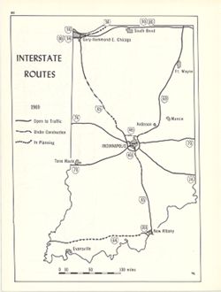
- Subject:
- Geographic Subject: Indiana and Topical Subject: Express highways
- Creator:
- Kingsbury, Robert C. and Hollingsworth, John M.
- Publisher:
- Indiana University, Bloomington. Department of Geography
- Date Created:
- 1970
- Identifier:
- VAC3073-M-00788
- Genre:
- Road maps
- Geographic Location:
- Coordinates: W0880700 W0844500 N0414500 N0374600
- Related URL:
- Catalog URL: https://iucat.iu.edu/catalog/15954745
- Abstract:
- Shows interstate routes open to traffic, under construction, and in planning. Detached from: An atlas of Indiana / by Robert C. Kingsbury , with contribut...
- Call Number:
- G4091.P2 1969 .K56
- Caption:
- Imprint: Bloomington, Indiana : Department of Geography, Indiana University, [1970]
- Physical Description:
- Scale: Approximately 1:2,000,000 and Dimensions: 26 x 18 cm, on sheet 28 x 21 cm
- Alternate Identifier:
- Alternate ID: 317383IP and Title Control Number: a15938019
- Persistent URL:
- https://purl.dlib.indiana.edu/iudl/images/VAC3073/VAC3073-M-00788
- Provenance:
- An atlas of Indiana / by Robert C. Kingsbury [1970].
-
- Subject:
- Topical Subject: Flood forecasting, Geographic Subject: Madison County (Ind.), Topical Subject: Floods, Geographic Subject: Alexandria Region (Ind.), and Top...
- Creator:
- Geological Survey (U.S.)
- Publisher:
- Geological Survey (U.S.)
- Date Created:
- 1970
- Identifier:
- VAC3073-M-00162
- Genre:
- 7.5 minute topographic maps, Topographic maps, and Quadrangle maps
- Geographic Location:
- Coordinates: W0854500 W0853730 N0402230 N0401500
- Related URL:
- Catalog URL: https://iucat.iu.edu/catalog/18416051
- Abstract:
- Filing title: Alexandria, Ind. Relief shown by contours and spot heights. Contour interval 10 feet. Includes quadrangle location map. Flood prone areas and o...
- Call Number:
- G4091.C32 s24 .G4 Alexandria 1970
- Caption:
- Imprint: Washington, D.C. : Interior--Geological Survey, [1970]
- Physical Description:
- Scale: 1:24,000 and Dimensions: 59 x 45 or smaller
- Alternate Identifier:
- Alternate ID: CAW5372BB and Title Control Number: a18416051
- Persistent URL:
- https://purl.dlib.indiana.edu/iudl/images/VAC3073/VAC3073-M-00162
- Provenance:
- United States Department of the Interior, Geological Survey. Map of flood-prone areas : [Indiana]. Washington, D.C. : The Survey, 1969-.
-
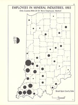
- Subject:
- Topical Subject: Mineral industries--Employees, Geographic Subject: Indiana, and Topical Subject: Labor supply
- Creator:
- Hollingsworth, John M. and Kingsbury, Robert C.
- Publisher:
- Indiana University. Department of Geography
- Date Created:
- 1970
- Identifier:
- VAC3073-M-00332
- Genre:
- Thematic maps
- Geographic Location:
- Coordinates: W0880700 W0844500 N0414500 N0374600
- Related URL:
- Catalog URL: https://iucat.iu.edu/catalog/15941776
- Abstract:
- Graduated symbol map. Shows number of employees by county. Detached from: An atlas of Indiana / by Robert C. Kingsbury , with contributions from John M. H...
- Call Number:
- G4091.G8 1963 .K56
- Caption:
- Imprint: Bloomington, Indiana : Department of Geography, Indiana University, [1970]
- Physical Description:
- Scale: Approximately 1:1,950,000 and Dimensions: 26 x 18 cm, on sheet 28 x 21 cm
- Alternate Identifier:
- Alternate ID: 317383IP and Title Control Number: a15941776
- Persistent URL:
- https://purl.dlib.indiana.edu/iudl/images/VAC3073/VAC3073-M-00332
- Provenance:
- An atlas of Indiana / by Robert C. Kingsbury [1970].
-
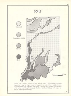
- Subject:
- Geographic Subject: Indiana and Topical Subject: Soils
- Creator:
- Kingsbury, Robert C. and Hollingsworth, John M.
- Publisher:
- Indiana University. Department of Geography
- Date Created:
- 1970
- Identifier:
- VAC3073-M-00134
- Genre:
- Thematic maps
- Geographic Location:
- Coordinates: W0880700 W0844500 N0414500 N0374600
- Related URL:
- Catalog URL: https://iucat.iu.edu/catalog/15939800
- Abstract:
- Detached from: An atlas of Indiana / by Robert C. Kingsbury , with contributions from John M. Hollingsworth and others. Bloomington, Indiana : Department of ...
- Call Number:
- G4091.J3 1970 .K56
- Caption:
- Imprint: Bloomington, Indiana : Department of Geography, Indiana University, [1970]
- Physical Description:
- Dimensions: 26 x 18 cm, on sheet 28 x 21 cm and Scale: Approximately 1:2,300,000
- Alternate Identifier:
- Alternate ID: 317383IP and Title Control Number: a15939800
- Persistent URL:
- https://purl.dlib.indiana.edu/iudl/images/VAC3073/VAC3073-M-00134
- Provenance:
- An atlas of Indiana / by Robert C. Kingsbury [1970].
-
- Subject:
- Topical Subject: Commuters and Geographic Subject: Indiana
- Creator:
- Indiana. Employment Security Division. Research and Statistics Section
- Publisher:
- Indiana. Employment Security Division. Research and Statistics Section
- Date Created:
- 1970
- Identifier:
- VAC3073-M-00354
- Genre:
- Statistical maps and Thematic maps
- Geographic Location:
- Coordinates: W0880500 W0844700 N0414500 N0374600
- Related URL:
- Catalog URL: https://iucat.iu.edu/catalog/1212285
- Abstract:
- "Source: 1970 census." "Counts of under 50 are omitted."
- Call Number:
- G4091 .G8 1970 .I53
- Caption:
- Imprint: [Indianapolis,] : The Research and statistics Section, Indiana Employment Security Division, [1970?]
- Physical Description:
- Dimensions: 25 x 17 cm and Scale: Scale not given.
- Alternate Identifier:
- Title Control Number: AKJ0410BB
- Persistent URL:
- https://purl.dlib.indiana.edu/iudl/images/VAC3073/VAC3073-M-00354
-
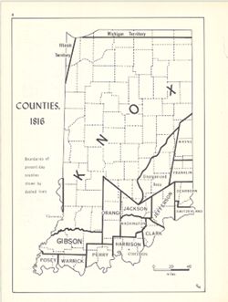
- Subject:
- Geographic Subject: Indiana, Topical Subject: Administrative and political divisions, Topical Subject: Historical geography, and Topical Subject: Counties
- Creator:
- Kingsbury, Robert C. and Hollingsworth, John M.
- Publisher:
- Indiana University. Department of Geography
- Date Created:
- 1970
- Identifier:
- VAC3073-M-00579
- Genre:
- Thematic maps
- Geographic Location:
- Coordinates: W0880700 W0844500 N0414500 N0374600
- Related URL:
- Catalog URL: https://iucat.iu.edu/catalog/15942510
- Abstract:
- Shows 1816 boundaries of Indiana counties. Detached from: An atlas of Indiana / by Robert C. Kingsbury , with contributions from John M. Hollingsworth and...
- Call Number:
- G4091.F7 1816 .K56
- Caption:
- Imprint: Bloomington, Indiana : Department of Geography, Indiana University, [1970]
- Physical Description:
- Dimensions: 26 x 18 cm, on sheet 28 x 21 cm and Scale: Approximately 1:1,950,000
- Alternate Identifier:
- Alternate ID: 317383IP and Title Control Number: a15942510
- Persistent URL:
- https://purl.dlib.indiana.edu/iudl/images/VAC3073/VAC3073-M-00579
- Provenance:
- An atlas of Indiana / by Robert C. Kingsbury [1970].
-
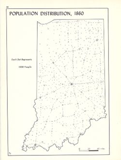
- Subject:
- Topical Subject: Population, Geographic Subject: Indiana, Topical Subject: Historical geography, and Topical Subject: Population geography
- Creator:
- Hollingsworth, John M. and Kingsbury, Robert C.
- Publisher:
- Indiana University. Department of Geography
- Date Created:
- 1970
- Identifier:
- VAC3073-M-00399
- Genre:
- Thematic maps
- Geographic Location:
- Coordinates: W0880700 W0844500 N0414500 N0374600
- Related URL:
- Catalog URL: https://iucat.iu.edu/catalog/15942895
- Abstract:
- Dot distribution map. Detached from: An atlas of Indiana / by Robert C. Kingsbury , with contributions from John M. Hollingsworth and others. Bloomington,...
- Call Number:
- G4091.E2 1860 .K56
- Caption:
- Imprint: Bloomington, Indiana : Department of Geography, Indiana University, [1970]
- Physical Description:
- Scale: Approximately 1:1,950,000 and Dimensions: 26 x 18 cm, on sheet 28 x 21 cm
- Alternate Identifier:
- Alternate ID: 317383IP and Title Control Number: a15942895
- Persistent URL:
- https://purl.dlib.indiana.edu/iudl/images/VAC3073/VAC3073-M-00399
- Provenance:
- An atlas of Indiana / by Robert C. Kingsbury [1970].
-
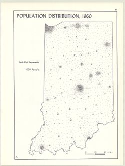
- Subject:
- Topical Subject: Population geography, Geographic Subject: Indiana, and Topical Subject: Population
- Creator:
- Kingsbury, Robert C. and Hollingsworth, John M.
- Publisher:
- Indiana University. Department of Geography
- Date Created:
- 1970
- Identifier:
- VAC3073-M-00662
- Genre:
- Thematic maps
- Geographic Location:
- Coordinates: W0880700 W0844500 N0414500 N0374600
- Related URL:
- Catalog URL: https://iucat.iu.edu/catalog/15942930
- Abstract:
- Dot distribution map. Detached from: An atlas of Indiana / by Robert C. Kingsbury , with contributions from John M. Hollingsworth and others. Bloomington,...
- Call Number:
- G4091.E2 1960 .K56
- Caption:
- Imprint: Bloomington, Indiana : Department of Geography, Indiana University, [1970]
- Physical Description:
- Dimensions: 26 x 18 cm, on sheet 28 x 21 cm and Scale: Approximately 1:1,950,000
- Alternate Identifier:
- Title Control Number: a15942930 and Alternate ID: 317383IP
- Persistent URL:
- https://purl.dlib.indiana.edu/iudl/images/VAC3073/VAC3073-M-00662
- Provenance:
- An atlas of Indiana / by Robert C. Kingsbury [1970].
-
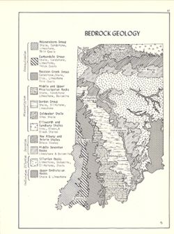
- Subject:
- Topical Subject: Geology, Geographic Subject: Indiana, and Topical Subject: Geology, Structural
- Creator:
- Hollingsworth, John M. and Kingsbury, Robert C.
- Publisher:
- Indiana University. Department of Geography
- Date Created:
- 1970
- Identifier:
- VAC3073-M-00305
- Genre:
- Geological maps
- Geographic Location:
- Coordinates: W0880700 W0844500 N0414500 N0374600
- Related URL:
- Catalog URL: https://iucat.iu.edu/catalog/15939159
- Abstract:
- Includes geological time table. Detached from: An atlas of Indiana / by Robert C. Kingsbury , with contributions from John M. Hollingsworth and others. Bl...
- Call Number:
- G4091.C5 1970 .K57
- Caption:
- Imprint: Bloomington, Indiana : Department of Geography, Indiana University, [1970]
- Physical Description:
- Dimensions: 26 x 18 cm, on sheet 28 x 21 cm and Scale: Approximately 1:2,150,000
- Alternate Identifier:
- Title Control Number: a15939159 and Alternate ID: 317383IP
- Persistent URL:
- https://purl.dlib.indiana.edu/iudl/images/VAC3073/VAC3073-M-00305
- Provenance:
- An atlas of Indiana / by Robert C. Kingsbury [1970].
-
- Subject:
- Geographic Subject: Indiana, Topical Subject: Names, Geographical, Topical Subject: Names, Indian, and Topical Subject: Indians of North America
- Creator:
- Guernsey, E. Y.
- Publisher:
- [Dept. of Conservation]
- Date Created:
- 1970
- Identifier:
- VAC3073-M-00121
- Genre:
- Thematic maps
- Geographic Location:
- Coordinates: W0880500 W0844700 N0414500 N0374600
- Related URL:
- Catalog URL: https://iucat.iu.edu/catalog/2251511
- Abstract:
- Blue line print. Originally published: Indianapolis: Dept. of Conservation, State of Indiana, 1933.
- Call Number:
- G4091 .E1 1932 .G8 1970
- Caption:
- Imprint: [Indianapolis] : [Dept. of Conservation], [1970?]
- Physical Description:
- Dimensions: 104 x 76 cm and Scale: Scale not given.
- Alternate Identifier:
- Title Control Number: BGX7088BB
- Persistent URL:
- https://purl.dlib.indiana.edu/iudl/images/VAC3073/VAC3073-M-00121
-
- Subject:
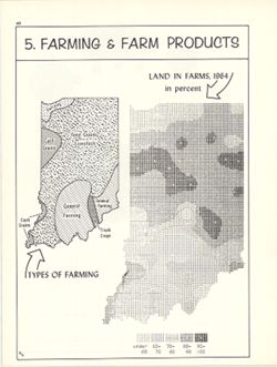
- Geographic Subject: Indiana, Topical Subject: Agricultural systems, Topical Subject: Farms, and Topical Subject: Agricultural resources
- Creator:
- Indiana University. Research Computing Center and Kingsbury, Robert C.
- Publisher:
- Indiana University. Department of Geography
- Date Created:
- 1970
- Identifier:
- VAC3073-M-00576
- Genre:
- Thematic maps
- Geographic Location:
- Coordinates: W0880700 W0844500 N0414500 N0374600
- Related URL:
- Catalog URL: https://iucat.iu.edu/catalog/15995409
- Abstract:
- Includes ancillary map Types of farming. Computer generated isopleth map obtained through use of the facilities of Indiana University's Research Computer...
- Call Number:
- G4091.J1 1964 .K58
- Caption:
- Imprint: Bloomington, Indiana : Department of Geography, Indiana University, [1970]
- Physical Description:
- Dimensions: 23 x 18 cm and Scale: Approximately 1:2,700,000
- Alternate Identifier:
- Alternate ID: 317383IP and Title Control Number: a15995409
- Persistent URL:
- https://purl.dlib.indiana.edu/iudl/images/VAC3073/VAC3073-M-00576
- Provenance:
- An atlas of Indiana / by Robert C. Kingsbury [1970].
-
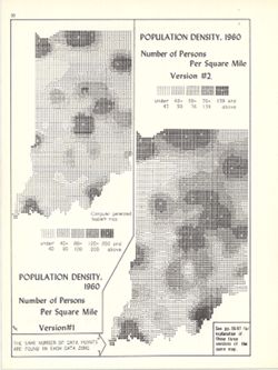
- Subject:
- Geographic Subject: Indiana and Topical Subject: Population density
- Creator:
- Indiana University. Research Computing Center, Hollingsworth, John M., and Kingsbury, Robert C.
- Publisher:
- Indiana University. Department of Geography
- Date Created:
- 1970
- Identifier:
- VAC3073-M-00604
- Genre:
- Thematic maps and Statistical maps
- Geographic Location:
- Coordinates: W0880700 W0844500 N0414500 N0374600
- Related URL:
- Catalog URL: https://iucat.iu.edu/catalog/15945746
- Abstract:
- 2 maps on 1 sheet. Two versions of map showing number of persons per square mile with different number ranges used data visualization. Computer generated iso...
- Call Number:
- G4091.E2 1960 .K57
- Caption:
- Imprint: Bloomington, Indiana : Department of Geography, Indiana University, [1970]
- Physical Description:
- Scale: Approximately 1:2,750,000 and Dimensions: 26 x 12 cm and 26 x 10 cm, on sheet 28 x 21 cm
- Alternate Identifier:
- Title Control Number: a15945746 and Alternate ID: 317383IP
- Persistent URL:
- https://purl.dlib.indiana.edu/iudl/images/VAC3073/VAC3073-M-00604
- Provenance:
- An atlas of Indiana / by Robert C. Kingsbury [1970].
-
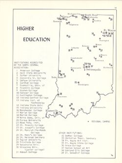
- Subject:
- Topical Subject: Education, higher, Geographic Subject: Indiana, and Topical Subject: Universities and colleges
- Creator:
- Hollingsworth, John M. and Kingsbury, Robert C.
- Publisher:
- Indiana University. Department of Geography
- Date Created:
- 1970
- Identifier:
- VAC3073-M-00065
- Genre:
- Thematic maps
- Geographic Location:
- Coordinates: W0880700 W0844500 N0414500 N0374600
- Related URL:
- Catalog URL: https://iucat.iu.edu/catalog/15942250
- Abstract:
- Shows locations of Indiana universities and colleges. Includes index of Institutions accredited by the North Central Association and other institutions. D...
- Call Number:
- G4091.E68 1970 .K56
- Caption:
- Imprint: Bloomington, Indiana : Department of Geography, Indiana University, [1970]
- Physical Description:
- Scale: Approximately 1:2,500,000 and Dimensions: 26 x 18 cm, on sheet 28 x 21 cm
- Alternate Identifier:
- Title Control Number: a15942250 and Alternate ID: 317383IP
- Persistent URL:
- https://purl.dlib.indiana.edu/iudl/images/VAC3073/VAC3073-M-00065
- Provenance:
- An atlas of Indiana / by Robert C. Kingsbury [1970].
-
- Subject:
- Geographic Subject: Indiana and Topical Subject: Phytogeography
- Creator:
- Hollingsworth, John M. and Kingsbury, Robert C.
- Publisher:
- Indiana University. Department of Geography
- Date Created:
- 1970
- Identifier:
- VAC3073-M-00916
- Genre:
- Thematic maps
- Geographic Location:
- Coordinates: W0880700 W0844500 N0414500 N0374600
- Related URL:
- Catalog URL: https://iucat.iu.edu/catalog/15941617
- Abstract:
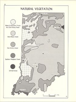
- Shows bluestem prairie, oak-hickory forest, beech and maple forest, southern floodplain forest, and elm-ash forest. Detached from: An atlas of Indiana / b...
- Call Number:
- G4091.D2 1970 .K56
- Caption:
- Imprint: Bloomington, Indiana : Department of Geography, Indiana University, [1970
- Physical Description:
- Scale: Approximately 1:1,950,000 and Dimensions: 26 x 18 cm, on sheet 28 x 21 cm
- Alternate Identifier:
- Alternate ID: 317383IP and Title Control Number: a15941617
- Persistent URL:
- https://purl.dlib.indiana.edu/iudl/images/VAC3073/VAC3073-M-00916
- Provenance:
- An atlas of Indiana / by Robert C. Kingsbury [1970].
-
- Subject:
- Topical Subject: Farm tractors, Topical Subject: SYMAP (Computer program language), Geographic Subject: Indiana, and Topical Subject: Pastures
- Creator:
- Indiana University. Research Computing Center and Kingsbury, Robert C.
- Publisher:
- Indiana University. Department of Geography
- Date Created:
- 1970
- Identifier:
- VAC3073-M-00148
- Genre:
- Thematic maps
- Geographic Location:
- Coordinates: W0880700 W0844500 N0414500 N0374600
- Related URL:
- Catalog URL: https://iucat.iu.edu/catalog/15995411
- Abstract:
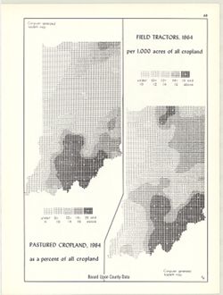
- 2 maps on 1 sheet, Pastured cropland, 1964, as a percent of all cropland and Field tractors, 1964, per 1,000 acres of all cropland. Computer generated isople...
- Call Number:
- G4091.J5 1964 .K55
- Caption:
- Imprint: Bloomington, Indiana : Department of Geography, Indiana University, [1970]
- Physical Description:
- Scale: Approximately 1:3,000,000 and Dimensions: each 26 x 10 cm, on sheet 28 x 21 cm
- Alternate Identifier:
- Title Control Number: a15995411 and Alternate ID: 317383IP
- Persistent URL:
- https://purl.dlib.indiana.edu/iudl/images/VAC3073/VAC3073-M-00148
- Provenance:
- An atlas of Indiana / by Robert C. Kingsbury [1970].
-
- Subject:
- Topical Subject: Watersheds, Topical Subject: Drainage, and Geographic Subject: Indiana
- Creator:
- Kingsbury, Robert C. and Hollingsworth, John M.
- Publisher:
- Indiana University. Department of Geography
- Date Created:
- 1970
- Identifier:
- VAC3073-M-00606
- Genre:
- Thematic maps
- Geographic Location:
- Coordinates: W0880700 W0844500 N0414500 N0374600
- Related URL:
- Catalog URL: https://iucat.iu.edu/catalog/15939801
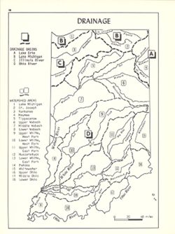
- Abstract:
- Shows drainage basins and watershed areas. Includes index. Detached from: An atlas of Indiana / by Robert C. Kingsbury , with contributions from John M. H...
- Call Number:
- G4091.C315 1970 .K56
- Caption:
- Imprint: Bloomington, Indiana : Department of Geography, Indiana University, [1970]
- Physical Description:
- Dimensions: 26 x 18 cm, on sheet 28 x 21 cm and Scale: Approximately 1:2,000,000
- Alternate Identifier:
- Title Control Number: a15939801 and Alternate ID: 317383IP
- Persistent URL:
- https://purl.dlib.indiana.edu/iudl/images/VAC3073/VAC3073-M-00606
- Provenance:
- An atlas of Indiana / by Robert C. Kingsbury [1970].
-
- Subject:
- Topical Subject: Labor supply, Topical Subject: Electric machinery industry--Employees, and Geographic Subject: Indiana
- Creator:
- Kingsbury, Robert C. and Hollingsworth, John M.
- Publisher:
- Indiana University. Department of Geography
- Date Created:
- 1970
- Identifier:
- VAC3073-M-00301
- Genre:
- Thematic maps
- Geographic Location:
- Coordinates: W0880700 W0844500 N0414500 N0374600
- Related URL:
- Catalog URL: https://iucat.iu.edu/catalog/15951253
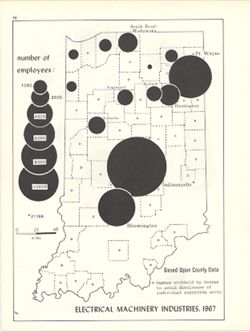
- Abstract:
- Graduated symbol map. Shows number of employees by county. Detached from: An atlas of Indiana / by Robert C. Kingsbury , with contributions from John M. H...
- Call Number:
- G4091.G8 1967 .K5
- Caption:
- Imprint: Bloomington, Indiana : Department of Geography, Indiana University, [1970]
- Physical Description:
- Dimensions: 26 x 18 cm, on sheet 28 x 21 cm and Scale: Approximately 1:1,950,000
- Alternate Identifier:
- Alternate ID: 317383IP and Title Control Number: a15951253
- Persistent URL:
- https://purl.dlib.indiana.edu/iudl/images/VAC3073/VAC3073-M-00301
- Provenance:
- An atlas of Indiana / by Robert C. Kingsbury [1970].
-
- Subject:
- Topical Subject: Physical geography, Geographic Subject: Indiana, Topical Subject: Glacial landforms, and Topical Subject: Physiographic provinces
- Creator:
- Hollingsworth, John M. and Kingsbury, Robert C.
- Publisher:
- Indiana University. Department of Geography
- Date Created:
- 1970
- Identifier:
- VAC3073-M-00917
- Genre:
- Geological maps and Physical maps
- Geographic Location:
- Coordinates: W0880700 W0844500 N0414500 N0374600
- Related URL:
- Catalog URL: https://iucat.iu.edu/catalog/15938768
- Abstract:
- Also shows Wisconsin glacial boundary and Illinoian glacial boundary. Detached from: An atlas of Indiana / by Robert C. Kingsbury , with contributions fro...
- Call Number:
- G4091.C21 1970 .K56
- Caption:
- Imprint: Bloomington, Indiana : Department of Geography, Indiana University, [1970]
- Physical Description:
- Dimensions: 26 x 18 cm, on sheet 28 x 21 cm and Scale: Approximately 1:2,000,000
- Alternate Identifier:
- Alternate ID: 317383IP and Title Control Number: a15938768
- Persistent URL:
- https://purl.dlib.indiana.edu/iudl/images/VAC3073/VAC3073-M-00917
- Provenance:
- An atlas of Indiana / by Robert C. Kingsbury [1970].
-
- Subject:
- Geographic Subject: Indiana, Topical Subject: Produce trade, and Topical Subject: Farm produce
- Creator:
- Hollingsworth, John M. and Kingsbury, Robert C.
- Publisher:
- Indiana University. Department of Geography
- Date Created:
- 1970
- Identifier:
- VAC3073-M-00685
- Genre:
- Thematic maps
- Geographic Location:
- Coordinates: W0880700 W0844500 N0414500 N0374600
- Related URL:
- Catalog URL: https://iucat.iu.edu/catalog/15986955
- Abstract:
- Graduated symbol map. Based upon county data, in millions of dollars. Detached from: An atlas of Indiana / by Robert C. Kingsbury , with contributions fro...
- Call Number:
- G4091.J6 1964 .K55
- Caption:
- Imprint: Bloomington, Indiana : Department of Geography, Indiana University, [1970]
- Physical Description:
- Dimensions: 26 x 18 cm, on sheet 28 x 21 cm and Scale: Approximately 1:1,950,000
- Alternate Identifier:
- Title Control Number: a15986955 and Alternate ID: 317383IP
- Persistent URL:
- https://purl.dlib.indiana.edu/iudl/images/VAC3073/VAC3073-M-00685
- Provenance:
- An atlas of Indiana / by Robert C. Kingsbury [1970].
-
- Subject:
- Topical Subject: Transportation, Geographic Subject: Indiana, and Topical Subject: Historical geography
- Creator:
- Hollingsworth, John M. and Kingsbury, Robert C.
- Publisher:
- Indiana University. Department of Geography
- Date Created:
- 1970
- Identifier:
- VAC3073-M-00255
- Genre:
- Thematic maps
- Geographic Location:
- Coordinates: W0880700 W0844500 N0414500 N0374600
- Related URL:
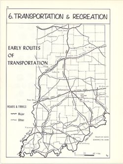
- Catalog URL: https://iucat.iu.edu/catalog/15937996
- Abstract:
- Shows rivers, canals, roads, trails, and the first Indiana railroad, important transportation routes during the Pioneer Era. Detached from: An atlas of In...
- Call Number:
- G4091.S1 1970 .K56
- Caption:
- Imprint: Bloomington, Indiana : Department of Geography, Indiana University, [1970]
- Physical Description:
- Dimensions: 23 x 18 cm, on sheet 28 x 21 cm and Scale: Approximately 1:2,000,000
- Alternate Identifier:
- Title Control Number: a15937996 and Alternate ID: 317383IP
- Persistent URL:
- https://purl.dlib.indiana.edu/iudl/images/VAC3073/VAC3073-M-00255
- Provenance:
- An atlas of Indiana / by Robert C. Kingsbury [1970].
-
- Subject:
- Topical Subject: Mineral industries, Topical Subject: Limestone industry, Geographic Subject: Indiana, Topical Subject: Oil fields, Topical Subject: Natural ...
- Creator:
- Kingsbury, Robert C. and Hollingsworth, John M.
- Publisher:
- Indiana University. Department of Geography
- Date Created:
- 1970
- Identifier:
- VAC3073-M-01019
- Genre:
- Thematic maps
- Geographic Location:
- Coordinates: W0880700 W0844500 N0414500 N0374600
- Related URL:
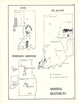
- Catalog URL: https://iucat.iu.edu/catalog/15954747
- Abstract:
- Shows oil and gas producing areas, strip mine areas and shaft mines extracting coal, and dimension limestone quarries and mills. Includes 2 ancillary maps an...
- Call Number:
- G4091.M2 1970 .K56
- Caption:
- Imprint: Bloomington, Indiana : Department of Geography, Indiana University, [1970]
- Physical Description:
- Scale: Approximately 1:3,000,000 and Dimensions: 26 x 18 cm, on sheet 28 x 21 cm
- Alternate Identifier:
- Title Control Number: a15954747 and Alternate ID: 317383IP
- Persistent URL:
- https://purl.dlib.indiana.edu/iudl/images/VAC3073/VAC3073-M-01019
- Provenance:
- An atlas of Indiana / by Robert C. Kingsbury [1970].
-
- Subject:
- Geographic Subject: Van Buren (Monroe County, Ind. : Township), Topical Subject: Karst, and Topical Subject: Watersheds
- Creator:
- Powell, Richard L.
- Publisher:
- [publisher not identified]
- Date Created:
- 1970
- Identifier:
- VAC3073-M-00338
- Genre:
- Thematic maps
- Geographic Location:
- Coordinates: W0864023 W0863813 N0390944 N0390627
- Related URL:
- Catalog URL: https://iucat.iu.edu/catalog/5327168
- Abstract:
- Blue line print. "Rlp-1970."
- Call Number:
- G4094.V28 C315 1970 .P69
- Caption:
- Imprint: [place of publication not identified] : [publisher not identified], 1970?]
- Physical Description:
- Scale: 1:12,000 and Dimensions: 46 x 46 cm
- Alternate Identifier:
- Title Control Number: a5327168
- Persistent URL:
- https://purl.dlib.indiana.edu/iudl/images/VAC3073/VAC3073-M-00338
-
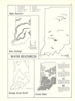
- Subject:
- Geographic Subject: Indiana, Topical Subject: Water-supply, Topical Subject: Groundwater, Topical Subject: Reservoirs, Topical Subject: Runoff, and Topical S...
- Creator:
- Hollingsworth, John M. and Kingsbury, Robert C.
- Publisher:
- Indiana University. Department of Geography
- Date Created:
- 1970
- Identifier:
- VAC3073-M-00970
- Genre:
- Thematic maps
- Geographic Location:
- Coordinates: W0880700 W0844500 N0414500 N0374600
- Related URL:
- Catalog URL: https://iucat.iu.edu/catalog/15941579
- Abstract:
- 4 maps on 1 sheet, River discharge, Major reservoirs, Average annual runoff and Ground water. Includes index for Major reservoirs map. Detached from: An a...
- Call Number:
- G1400 .K53 1970
- Caption:
- Imprint: Bloomington, Indiana : Department of Geography, Indiana University, [1970]
- Physical Description:
- Scale: Approximately 1:3,500,000 and Dimensions: on sheet 28 x 21 cm
- Alternate Identifier:
- Alternate ID: 317383IP and Title Control Number: a15941579
- Persistent URL:
- https://purl.dlib.indiana.edu/iudl/images/VAC3073/VAC3073-M-00970
- Provenance:
- An atlas of Indiana / by Robert C. Kingsbury [1970].
-
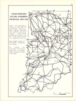
- Subject:
- Geographic Subject: Indiana and Topical Subject: Electric railroads
- Creator:
- Hollingsworth, John M. and Kingsbury, Robert C.
- Publisher:
- Indiana University. Department of Geography
- Date Created:
- 1970
- Identifier:
- VAC3073-M-00908
- Genre:
- Thematic maps
- Geographic Location:
- Coordinates: W0880700 W0844500 N0414500 N0374600
- Related URL:
- Catalog URL: https://iucat.iu.edu/catalog/15934645
- Abstract:
- Shows approximate routes of over 250 incorporated companies. Detached from: An atlas of Indiana / by Robert C. Kingsbury , with contributions from John M...
- Call Number:
- G4091.P3 1915 .K57
- Caption:
- Imprint: Bloomington, Indiana : Department of Geography, Indiana University, [1970]
- Physical Description:
- Dimensions: 26 x 18 cm, on sheet 28 x 21 cm and Scale: Approximately 1:1,950,000
- Alternate Identifier:
- Alternate ID: 317383IP and Title Control Number: a15934645
- Persistent URL:
- https://purl.dlib.indiana.edu/iudl/images/VAC3073/VAC3073-M-00908
- Provenance:
- An atlas of Indiana / by Robert C. Kingsbury [1970].
-
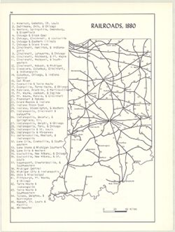
- Subject:
- Topical Subject: Railroads and Geographic Subject: Indiana
- Creator:
- Kingsbury, Robert C. and Hollingsworth, John M.
- Publisher:
- Indiana University. Department of Geography
- Date Created:
- 1970
- Identifier:
- VAC3073-M-00313
- Genre:
- Thematic maps
- Geographic Location:
- Coordinates: W0880700 W0844500 N0414500 N0374600
- Related URL:
- Catalog URL: https://iucat.iu.edu/catalog/15934621
- Abstract:
- Includes index of railroads. Detached from: An atlas of Indiana / by Robert C. Kingsbury , with contributions from John M. Hollingsworth and others. Bloom...
- Call Number:
- G4091.P3 1880 .K56
- Caption:
- Imprint: Bloomington, Indiana : Department of Geography, Indiana University, [1970]
- Physical Description:
- Scale: Approximately 1:2,300,000 and Dimensions: 26 x 18 cm, on sheet 28 x 21 cm
- Alternate Identifier:
- Title Control Number: a15934621 and Alternate ID: 317383IP
- Persistent URL:
- https://purl.dlib.indiana.edu/iudl/images/VAC3073/VAC3073-M-00313
- Provenance:
- An atlas of Indiana / by Robert C. Kingsbury [1970].
-
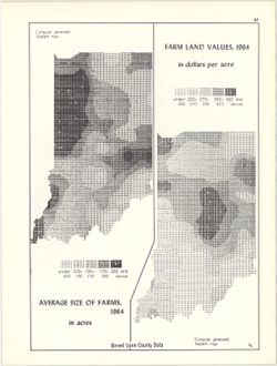
- Subject:
- Topical Subject: Farms, Topical Subject: SYMAP (Computer program language), Geographic Subject: Indiana, and Topical Subject: Agricultural resources
- Creator:
- Indiana University. Research Computing Center, Hollingsworth, John M., and Kingsbury, Robert C.
- Publisher:
- Indiana University. Department of Geography
- Date Created:
- 1970
- Identifier:
- VAC3073-M-00865
- Genre:
- Thematic maps
- Geographic Location:
- Coordinates: W0880700 W0844500 N0414500 N0374600
- Related URL:
- Catalog URL: https://iucat.iu.edu/catalog/15995407
- Abstract:
- 2 maps on 1 sheet, Farm land values, 1964, in dollars per acre and Average size of farms, 1964, in acres. Computer generated isopleth maps obtained through u...
- Call Number:
- G4091.J1 1964 .K57
- Caption:
- Imprint: Bloomington, Indiana : Department of Geography, Indiana University, [1970]
- Physical Description:
- Scale: Approximately 1:3,000,000 and Dimensions: each 26 x 10 cm, on sheet 28 x 21 cm
- Alternate Identifier:
- Alternate ID: 317383IP and Title Control Number: a15995407
- Persistent URL:
- https://purl.dlib.indiana.edu/iudl/images/VAC3073/VAC3073-M-00865
- Provenance:
- An atlas of Indiana / by Robert C. Kingsbury [1970].
-
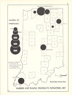
- Subject:
- Topical Subject: Labor supply, Geographic Subject: Indiana, Topical Subject: Rubber industry workers, and Topical Subject: Plastics workers
- Creator:
- Hollingsworth, John M. and Kingsbury, Robert C.
- Publisher:
- Indiana University. Department of Geography
- Date Created:
- 1970
- Identifier:
- VAC3073-M-00398
- Genre:
- Statistical maps and Thematic maps
- Geographic Location:
- Coordinates: W0880700 W0844500 N0414500 N0374600
- Related URL:
- Catalog URL: https://iucat.iu.edu/catalog/15950738
- Abstract:
- Graduated symbol map. Shows number of employees by county. Detached from: An atlas of Indiana / by Robert C. Kingsbury , with contributions from John M. H...
- Call Number:
- G4091.G8 1967 .K54
- Caption:
- Imprint: Bloomington, Indiana : Department of Geography, Indiana University, [1970]
- Physical Description:
- Dimensions: 26 x 18 cm, on sheet 28 x 21 cm and Scale: Approximately 1:1,950,000
- Alternate Identifier:
- Title Control Number: a15950738 and Alternate ID: 317383IP
- Persistent URL:
- https://purl.dlib.indiana.edu/iudl/images/VAC3073/VAC3073-M-00398
- Provenance:
- An atlas of Indiana / by Robert C. Kingsbury [1970].
