Search Constraints
You searched for:
Campus
IUB
Remove constraint Campus: IUB
Collections
Indiana Historic Maps
Remove constraint Collections: Indiana Historic Maps
Pages
0-99 pages
Remove constraint Pages: 0-99 pages
Subject
Topical Subject: Land use
Remove constraint Subject: Topical Subject: Land use

![[Monroe County, Indiana, existing use of land.] Sheet 14. Unincorporated communities, Monroe County, Indiana, existing use of land](https://iiif.uits.iu.edu/iiif/2/zk51wj270%2Ffiles%2F62b7ef2f-84c1-4e40-a5e2-39ef248cf3ce/full/250,/0/default.jpg)
![[Monroe County, Indiana, existing use of land.] Sheet 13. Washington Township, Monroe County, Indiana, existing use of land](https://iiif.uits.iu.edu/iiif/2/nc581p990%2Ffiles%2F07609495-360c-4713-9c4e-887099eaa1cc/full/250,/0/default.jpg)
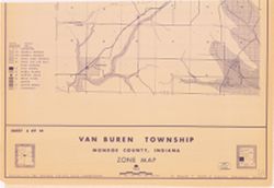
![[Monroe County, Indiana, existing use of land.] Sheet 6. Van Buren Township, Monroe County, Indiana, existing use of land](https://iiif.uits.iu.edu/iiif/2/js957j36n%2Ffiles%2Fb7c53c79-855f-4c3c-87bb-abc60884f2ba/full/250,/0/default.jpg)
![[Monroe County, Indiana, existing use of land.] Sheet 10. Salt Creek Township, Monroe County, Indiana, existing use of land](https://iiif.uits.iu.edu/iiif/2/41688m61r%2Ffiles%2F794b5ec7-9465-4a56-a95f-23c98afc60dc/full/250,/0/default.jpg)
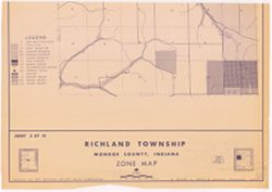
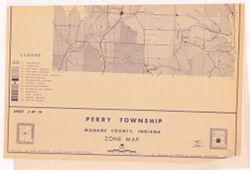
![[Monroe County, Indiana, existing use of land.] Sheet 5. Richland Township, Monroe County, Indiana, existing use of land](https://iiif.uits.iu.edu/iiif/2/2z10xt559%2Ffiles%2Fccd422c0-2373-4819-b6e9-60a0db266735/full/250,/0/default.jpg)
![[Monroe County, Indiana, existing use of land.] Sheet 9. Polk Township, Monroe County, Indiana, existing use of land](https://iiif.uits.iu.edu/iiif/2/th83n346m%2Ffiles%2F98da6cf6-258c-482d-aae7-a3cd05bc5456/full/250,/0/default.jpg)