
Search Constraints
You searched for:
Publisher
Indiana. Department of Geology and Natural Resources
Remove constraint Publisher: Indiana. Department of Geology and Natural Resources
« Previous |
1 - 10 of 196
|
Next »
Search Results
-
- Subject:
- Topical Subject: IGS Annual Reports, Topical Subject: Mines and mineral resources, Topical Subject: Road materials, and Geographic Subject: Monroe County (Ind.)
- Publisher:
- Indiana. Department of Geology and Natural Resources
- Date Created:
- 1906
- Identifier:
- VAC3073-M-01160
- Genre:
- Geological maps
- Geographic Location:
- Coordinates: W0864107 W0861903 N0392122 N0385936
- Related URL:
- Catalog URL: https://iucat.iu.edu/catalog/18299087
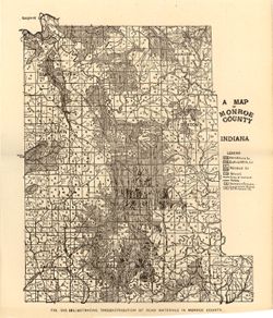
- Abstract:
- Alternate title: Illustrating the distribution of road materials in Monroe County. At head of alternate title: Fig. 53B. Shows roads, limestone, gravel, sand...
- Call Number:
- G4093.M7H5 1905 .M3
- Caption:
- Imprint: [Indianapolis] : [Indiana Dept. of Geology and Natural Resources], [1906]
- Physical Description:
- Scale: Approximately 1:171,000 and Dimensions: 26 x 22 cm
- Alternate Identifier:
- Alternate ID: 390726IP and Title Control Number: a18299087
- Persistent URL:
- https://purl.dlib.indiana.edu/iudl/images/VAC3073/VAC3073-M-01160
- Provenance:
- 30th Annual Report (1905) / Indiana. Department of Geology and Natural Resources.
-

- Subject:
- Geographic Subject: Indiana, Geographic Subject: Ripley County (Ind.), Topical Subject: IGS Annual Reports, Geographic Subject: Jefferson County (Ind.), Topi...
- Creator:
- Cumings, E. R. (Edgar Roscoe), 1874-1967 and Foerste, Aug. F. (Aug. Frederic), 1862-1936
- Publisher:
- Indiana. Department of Geology and Natural Resources
- Date Created:
- 1908
- Identifier:
- VAC3073-M-01028
- Genre:
- Geological maps
- Geographic Location:
- Coordinates: W0854100 W0844600 N0391800 N0383300
- Related URL:
- Catalog URL: https://iucat.iu.edu/catalog/18307520
- Abstract:
- "Boundary after Foerste." Detached from: The stratigraphy and paleontology of the Cincinnati series of Indiana / E.R. Cumings. In Indiana Dept. ...
- Call Number:
- G4091.C57 1908 .M3
- Caption:
- Imprint: [Indianapolis] : [Indiana Dept. of Geology and Natural Resources], [1908]
- Physical Description:
- Dimensions: on sheet 60 x 51 cm and Scale: Approximately 1:126,720. 2 miles to the 1 inch
- Alternate Identifier:
- Title Control Number: a18307520 and Alternate ID: 390726IP
- Persistent URL:
- https://purl.dlib.indiana.edu/iudl/images/VAC3073/VAC3073-M-01028
- Provenance:
- 32nd Annual Report (1907) / Indiana. Department of Geology and Natural Resources.
-
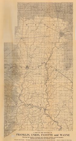
- Subject:
- Geographic Subject: Union County (Ind.), Geographic Subject: Franklin County (Ind.), Topical Subject: IGS Annual Reports, Geographic Subject: Indiana, Topica...
- Publisher:
- Indiana. Department of Geology and Natural Resources
- Date Created:
- 1908
- Identifier:
- VAC3073-M-00272
- Genre:
- Geological maps
- Related URL:
- Catalog URL: https://iucat.iu.edu/catalog/9676901
- Abstract:
- Showing the Location of sections and collecting localities and the boundary between the Ordovician and Silurian Systems. Detached from: The stratigraphy a...
- Call Number:
- QE109 .A2 1907 map p605
- Caption:
- Imprint: Indianapolis : 1908
- Physical Description:
- Dimensions: 67 x 37 cm and Scale: Approximately 1:126,720. 2 miles = 1 inch
- Alternate Identifier:
- Title Control Number: 390726IP
- Persistent URL:
- https://purl.dlib.indiana.edu/iudl/images/VAC3073/VAC3073-M-00272
- Provenance:
- 32nd Annual Report (1907) / Indiana. Department of Geology and Natural Resources.
-
- Subject:
- Topical Subject: Roads, Topical Subject: IGS Annual Reports, and Geographic Subject: Monroe County (Ind.)
- Publisher:
- Indiana. Department of Geology and Natural Resources
- Date Created:
- 1906
- Identifier:
- VAC3073-M-00037
- Genre:
- Road maps
- Geographic Location:
- Coordinates: W0864107 W0861811 N0392126 N0385936
- Related URL:
- Catalog URL: https://iucat.iu.edu/catalog/18298783
- Abstract:
- Shows roads, improved roads, rural routes, rail roads, and road metal quarries. Alternate title: Illustrating the roads of Monroe County. At head of alternat...
- Call Number:
- G4093.M7P2 1905 .R6
- Caption:
- Imprint: Indianapolis : 1906
- Physical Description:
- Scale: Approximately 1:130,000 and Dimensions: 36 x 27 cm
- Alternate Identifier:
- Alternate ID: 390726IP and Title Control Number: a18298783
- Persistent URL:
- https://purl.dlib.indiana.edu/iudl/images/VAC3073/VAC3073-M-00037
- Provenance:
- 30th Annual Report (1905) / Indiana. Department of Geology and Natural Resources.
-
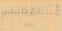
- Subject:
- Geographic Subject: Richmond (Ind.), Topical Subject: IGS Annual Reports, Geographic Subject: Madison (Ind.), Topical Subject: Stratigraphic correlation, Top...
- Creator:
- Cumings, E. R. (Edgar Roscoe), 1874-1967
- Publisher:
- Indiana. Department of Geology and Natural Resources
- Date Created:
- 1908
- Identifier:
- VAC3073-M-00056
- Genre:
- Charts and Geological cross-sections
- Geographic Location:
- Coordinates: W0852400 W0844800 N0395000 N0384000
- Related URL:
- Catalog URL: https://iucat.iu.edu/catalog/18298808
- Abstract:
- Includes 17 stratigraphic columns and correlation lines. Detached from: The stratigraphy and paleontology of the Cincinnati series of Indiana / E.R. Cumin...
- Call Number:
- G4091.C57 1908 .C86
- Caption:
- Imprint: [Indianapolis] : [Wm. B. Burford], [1908] and Imprint: [Indianapolis] : [Indiana Department of Geology and Natural Resources], [1908]
- Physical Description:
- Dimensions: on sheet 32 x 60 cm and Scale: Scale not given.
- Alternate Identifier:
- Title Control Number: a18298808 and Alternate ID: 390726IP
- Persistent URL:
- https://purl.dlib.indiana.edu/iudl/images/VAC3073/VAC3073-M-00056
- Provenance:
- 32nd Annual Report (1907) / Indiana. Department of Geology and Natural Resources.
-
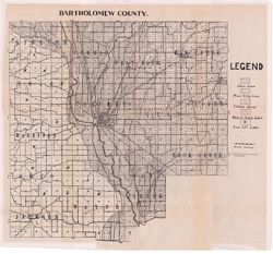
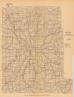
- Subject:
- Geographic Subject: Bartholomew County (Ind.) and Topical Subject: Soils
- Creator:
- Indiana. Department of Geology and Natural Resources
- Publisher:
- Indiana. Department of Geology and Natural Resources
- Date Created:
- 1912
- Identifier:
- VAC3073-M-01088
- Genre:
- Thematic maps
- Geographic Location:
- Coordinates: W0860508 W0854104 N0392100 N0390209
- Related URL:
- Catalog URL: https://iucat.iu.edu/catalog/16136919
- Abstract:
- Shows roads and railroads. Detached from: Soil survey of Bartholomew County / E.J. Quinn. In Thirty-sixth annual report of Department of Geology and Natur...
- Call Number:
- G4093.B3J3 1911 .I53
- Caption:
- Imprint: [Indianapolis] : [Department of Geology and Natural Resources], [1912] and Imprint: [Indianapolis] : [Wm. B. Burford], [1912]
- Physical Description:
- Dimensions: 40 x 41 cm, on sheet 44 x 49 cm and Scale: Approximately 1:85,000
- Alternate Identifier:
- Alternate ID: 390726IP and Title Control Number: a16136919
- Persistent URL:
- https://purl.dlib.indiana.edu/iudl/images/VAC3073/VAC3073-M-01088
- Provenance:
- 36th Annual Report (1911) / Indiana. Department of Geology and Natural Resources.
-
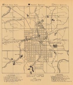
- Subject:
- Geographic Subject: Lawrence County (Ind.), Topical Subject: Stone-cutting, Topical Subject: Limestone industry, Geographic Subject: Bedford (Ind.), and Topi...
- Creator:
- Blatchley, Raymond S. (Raymond Sillliman)
- Publisher:
- Indiana. Department of Geology and Natural Resources
- Date Created:
- 1908
- Identifier:
- VAC3073-M-00628
- Genre:
- Road maps and Thematic maps
- Geographic Location:
- Coordinates: W0863134 W0862736 N0385324 N0385042
- Related URL:
- Catalog URL: https://iucat.iu.edu/catalog/18299189
- Abstract:
- "The 15 etching maps of the individual quarries or quarry districts, have been written and prepared by Raymond S. Blatchley from data gathered by him pe...
- Call Number:
- G4094.B3M2 1907 .B53
- Caption:
- Imprint: [Indianapolis] : [Indiana Department of Geology and Natural Resources], [1908]
- Physical Description:
- Dimensions: 23 x 20 cm and Scale: Scale not given.
- Alternate Identifier:
- Alternate ID: 390726IP and Title Control Number: a18299189
- Persistent URL:
- https://purl.dlib.indiana.edu/iudl/images/VAC3073/VAC3073-M-00628
- Provenance:
- 32nd Annual Report (1907) / Indiana. Department of Geology and Natural Resources.
-
![Bloomington [stone mills and quarries]](https://iiif.uits.iu.edu/iiif/2/2z10xt541%2Ffiles%2Fe56b5fe6-690b-41df-b566-a4f36f32b932/full/250,/0/default.jpg)
- Subject:
- Topical Subject: IGS Annual Reports, Topical Subject: Abandoned quarries, Topical Subject: Limestone industry, Geographic Subject: Bloomington (Ind.), and To...
- Creator:
- Blatchley, Raymond S. (Raymond Sillliman)
- Publisher:
- Indiana. Department of Geology and Natural Resources
- Date Created:
- 1908
- Identifier:
- VAC3073-M-01006
- Genre:
- Thematic maps
- Geographic Location:
- Coordinates: W0863336 W0863018 N0391047 N0390805
- Related URL:
- Catalog URL: https://iucat.iu.edu/catalog/18298788
- Abstract:
- "The 15 etching maps of the individual quarries or quarry districts, have been written and prepared by Raymond S. Blatchley from data gathered by him pe...
- Call Number:
- G4094.B5 1907 .B53
- Caption:
- Imprint: [Indianapolis] : [Wm. B. Burford], [1908] and Imprint: [Indianapolis] : [Indiana Department of Geology and Natural Resources], [1908]
- Physical Description:
- Scale: Approximately 1:17,000 and Dimensions: 23 x 21 cm
- Alternate Identifier:
- Alternate ID: 390726IP and Title Control Number: a18298788
- Persistent URL:
- https://purl.dlib.indiana.edu/iudl/images/VAC3073/VAC3073-M-01006
- Provenance:
- 32nd Annual Report (1907) / Indiana. Department of Geology and Natural Resources.
-
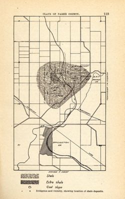
- Subject:
- Geographic Subject: Bridgeton Region (Ind.), Topical Subject: Mines and mineral resources, Geographic Subject: Parke County (Ind.), Topical Subject: IGS Annu...
- Publisher:
- Indiana. Department of Geology and Natural Resources
- Date Created:
- 1905
- Identifier:
- VAC3073-M-01585
- Genre:
- Geological maps
- Geographic Location:
- Coordinates: W0871115 W0870900 N0394130 N0393800
- Related URL:
- Catalog URL: https://iucat.iu.edu/catalog/18279221
- Abstract:
- Shows location of shale, extra shale, and coal slope. "Clays of Parke County." Detached from: The clays and clay industries of Indiana / W. S. B...
- Call Number:
- G4093.P2H5 1904 .B75
- Caption:
- Imprint: [Indianapolis] : [Indiana Department of Geology and Natural Resources], [1905] and Imprint: [Indianapolis] : [Wm. B. Burford], [1905]
- Physical Description:
- Scale: Scale not given. and Dimensions: on sheet 22 x 14 cm
- Alternate Identifier:
- Alternate ID: 390726IP and Title Control Number: a18279221
- Persistent URL:
- https://purl.dlib.indiana.edu/iudl/images/VAC3073/VAC3073-M-01585
- Provenance:
- 29th Annual Report (1904) / Indiana. Department of Geology and Natural Resources.
-
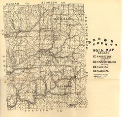
- Subject:
- Topical Subject: Soils and Geographic Subject: Brown County (Ind.)
- Creator:
- Indiana. Department of Geology and Natural Resources
- Publisher:
- Indiana. Department of Geology and Natural Resources
- Date Created:
- 1908
- Identifier:
- VAC3073-M-01149
- Genre:
- Thematic maps
- Geographic Location:
- Coordinates: W0862253 W0860444 N0392039 N0390254
- Related URL:
- Catalog URL: https://iucat.iu.edu/catalog/16095832
- Abstract:
- Shows railroads, dirt roads, improved roads, and schools. Detached from: Soil survey of Monroe, Brown, Lawrence, Martin, Orange, Washington, and Jackson c...
- Call Number:
- G4093.B6J3 1907 .I53
- Caption:
- Imprint: [Indianapolis] : [Indiana Dept. of Geology and Natural Resources], [1908]
- Physical Description:
- Dimensions: 26 x 20 cm and Scale: Approximately 1:126,720
- Alternate Identifier:
- Alternate ID: 390726IP and Title Control Number: a16095832
- Persistent URL:
- https://purl.dlib.indiana.edu/iudl/images/VAC3073/VAC3073-M-01149
- Provenance:
- 32nd Annual Report (1907) / Indiana. Department of Geology and Natural Resources.
