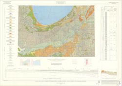
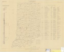
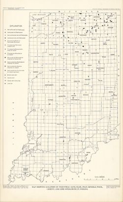
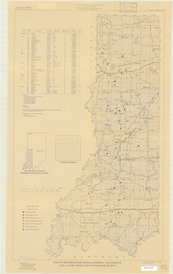
Includes generalized columnar section, "Sectionized township," and index of producers of clay and clay products. "Base modified from U.S. Geol...
"This map data was compiled in 1997 from information available at the time, but was unpublished until until 2002, the map does not reflect any changes i...
Topical Subject: Coal mines and mining and Geographic Subject: Indiana
Creator:
Hutchison, Harold C. (Harold Christy), 1925-
Publisher:
Indiana. Geological Survey
Date Created:
1974
Identifier:
VAC3073-M-00711
Genre:
Thematic maps and Mine maps
Geographic Location:
Coordinates: W0880100 W0862800 N0403900 N0374500
Related URL:
Catalog URL: https://iucat.iu.edu/catalog/5046466
Abstract:
Blue line print. "Base modified from Indiana Department of Conservation, Geological Survey. Base map of portion of western Indiana, 1951." Includes...
Topical Subject: Coal mines and mining and Geographic Subject: Indiana
Creator:
Hutchison, Harold C. (Harold Christy), 1925-
Publisher:
Indiana. Geological Survey
Date Created:
1975
Identifier:
VAC3073-M-00704
Genre:
Mine maps
Geographic Location:
Coordinates: W0872723 W0862628 N0403749 N0374618
Related URL:
Catalog URL: https://iucat.iu.edu/catalog/5050615
Abstract:
Blue line print. "Base modified from Indiana Department of Conservation, Geological Survey, Base map of portion of western Indiana, 1951." Includes...
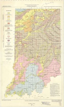
"Modified from Regional Geologic Map Series, Indiana Geological Survey." Includes insets of "Thickness of unconsolidated materials" and &...
Geographic Subject: Clay County (Ind.), Topical Subject: IGS Annual Reports, and Topical Subject: Coal
Creator:
Levette, G. M. (Gilbert M.)
Publisher:
Indiana. Geological Survey
Date Created:
1869
Identifier:
VAC3073-M-00669
Genre:
Thematic maps
Geographic Location:
Coordinates: W0871400 W0865700 N0393700 N0391000
Related URL:
Catalog URL: https://iucat.iu.edu/catalog/2800455
Abstract:
Shows cities and towns, railroads, coal, iron ore, and blast furnaces. "For the first annual report of Prof. E. T. Cox, State Geologist." Detach...
Call Number:
G4093 .C5H1 1869 .L3
Caption:
Imprint: [Indianapolis] : [Alexander M. Conner], [1869]
Physical Description:
Dimensions: 77 x 69 cm and Scale: Approximately 1:85,000
Alternate Identifier:
Alternate ID: CAH3779BB and Title Control Number: a18224823
Geographic Subject: Indiana, Topical Subject: Mineral industries, and Topical Subject: Mineral resources
Creator:
Smith, Ned M. (Ned Myron), Guennel, G. K., Patton, John B. (John Barratt), 1915-, Wayne, William J. (William John), 1922-, and Murray, Haydn H. (Haydn Herber...
Publisher:
Indiana. Geological Survey
Date Created:
1953
Identifier:
VAC3073-M-00645
Genre:
Thematic maps
Geographic Location:
Coordinates: W0880500 W0844700 N0414500 N0374600
Related URL:
Catalog URL: No Record at this time
Abstract:
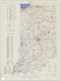
"Base from Map of Indiana, 1950 edition, published by U.S. Geological Survey. Minor revisions made from Indiana Dept. of Conservation, Geological Survey...
Call Number:
0.00E+00
Caption:
Imprint: [Bloomington, In.:] Indiana Department of Conservation, Geological Survey, 1953.
Physical Description:
Scale: 1:1,000,000 and Dimensions: 46 x 31 cm
Alternate Identifier:
Title Control Number: https://iucat.iu.edu/catalog/18571114 and Alternate ID: a18571114
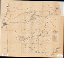
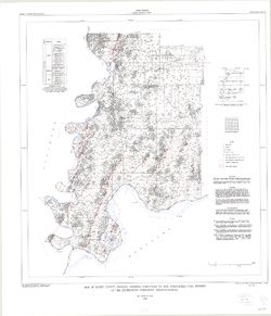
Geographic Subject: Warren County (Ind.), Topical Subject: Coal mines and mining, Geographic Subject: Vermillion County (Ind.), and Geographic Subject: Fount...
Creator:
Hutchison, Harold C. (Harold Christy), 1925-
Publisher:
Indiana. Geological Survey
Date Created:
1961
Identifier:
VAC3073-M-00418
Genre:
Mine maps
Geographic Location:
Coordinates: W0873200 W0870533 N0402800 N0395645
Related URL:
Catalog URL: https://iucat.iu.edu/catalog/4898738
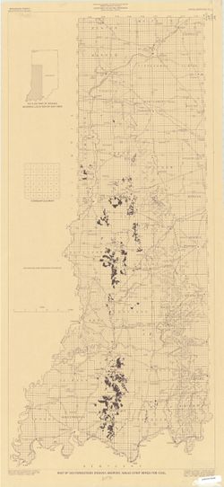
Abstract:
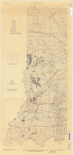
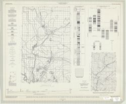
"Preliminary coal map no. 9"--Margin. Includes 1 ancillary map, 1 diagram showing township enumeration, 1 index map, 1 stratigraphic column, and 1 ...
Call Number:
G4093.F6H9 1961 .H88
Caption:
Imprint: Bloomington : Indiana Dept. of Conservation, Geological Survey, 1961.
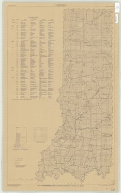
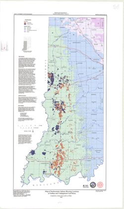
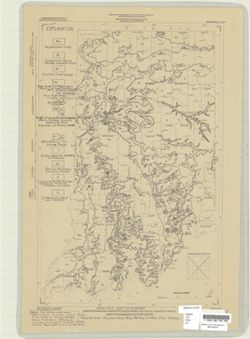
Geographic Subject: Indiana and Topical Subject: Coal mines and mining
Publisher:
Indiana. Geological Survey
Date Created:
2000
Identifier:
VAC3073-M-00283
Genre:
Geological maps
Related URL:
Catalog URL: https://iucat.iu.edu/catalog/4898390
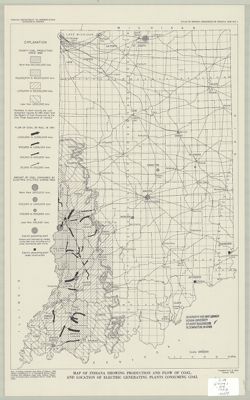
Abstract:
"Minde data compilation complete through October 1997." "All mine data shown on this map are recompiled by IGS personnel as part of the Co...
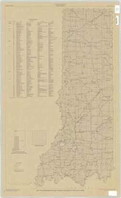
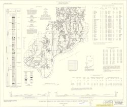
Geographic Subject: Spencer County (Ind.), Topical Subject: Coal mines and mining, and Topical Subject: Coal
Creator:
Hutchison, Harold C. (Harold Christy), 1925-
Publisher:
Indiana. Geological Survey
Date Created:
1959
Identifier:
VAC3073-M-00222
Genre:
Mine maps and Thematic maps
Geographic Location:
Coordinates: W0871600 W0844600 N0381200 N0374700
Related URL:
Catalog URL: https://iucat.iu.edu/catalog/5389271
Abstract:
"Preliminary Coal Map no. 8". Includes 2 geologic cross sections, location map, geologic column, index of mines, tables, and diagram of township se...
Call Number:
G4093.S5H9 1959 .H8
Caption:
Imprint: Bloomington, Ind. : Indiana Department of Conservation, Geological Survey, 1959.
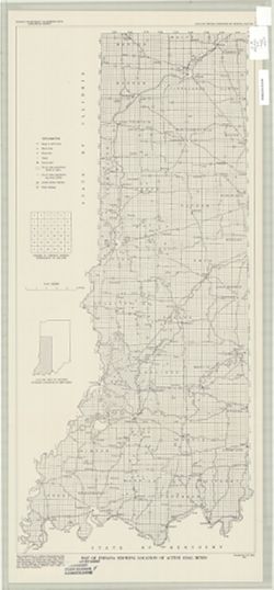
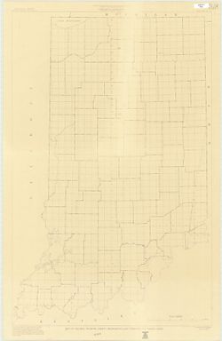
Topical Subject: Administrative and political divisions and Geographic Subject: Indiana
Creator:
Moran, W. H. (William H.)
Publisher:
Indiana. Geological Survey
Date Created:
1952
Identifier:
VAC3073-M-00215
Genre:
Maps
Geographic Location:
Coordinates: W0880500 W0844700 N0414500 N0374600
Related URL:
Catalog URL: https://iucat.iu.edu/catalog/1233088
Abstract:
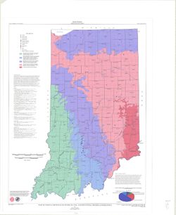
"January 1952." Black line print. "Traced from Map of Indiana, edition of 1950, published by U.S. Geological Survey. Minor revisions and addit...
Topical Subject: Geology and Geographic Subject: Indiana
Creator:
Patton, John B. (John Barratt), 1915-
Publisher:
Indiana. Geological Survey
Date Created:
1956
Identifier:
VAC3073-M-00212
Genre:
Geological maps
Geographic Location:
Coordinates: W0880000 W0844500 N0414500 N0375200
Related URL:
Catalog URL: https://iucat.iu.edu/catalog/5888483
Abstract:
"Base from Map of Indiana, 1950 edition, published by the U.S. Geological Survey. Minor revisions and additions made from Indiana Department of Conserva...
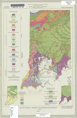
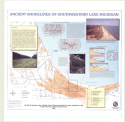
Geographic Subject: Porter County (Ind.), Geographic Subject: Indiana, Geographic Subject: Michigan, Lake, Coast (Ind.), Topical Subject: Lakes, Topical Subj...
Creator:
Thompson, Todd A. (Todd Alan), 1959-
Publisher:
Indiana. Geological Survey
Date Created:
2000
Identifier:
VAC3073-M-00193
Genre:
Thematic maps
Geographic Location:
Coordinates: W0873136 W0871307 N0414539 N0410943
Related URL:
Catalog URL: https://iucat.iu.edu/catalog/4898581
Abstract:
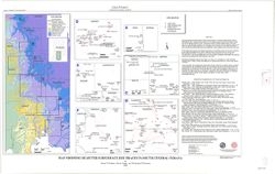
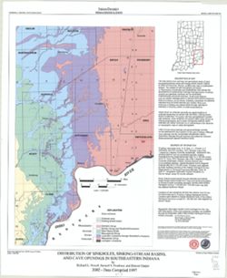
Includes illustrations, text, graphs showing "Lake-level fluctuations over the past 4,700 years" and a timeline showing historical events since 116...
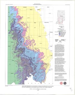
Topical Subject: Caves, Geographic Subject: Indiana, Topical Subject: Springs, Topical Subject: Sinkholes, and Topical Subject: Karst
Creator:
Powell, Richard L.
Publisher:
Indiana. Geological Survey
Date Created:
2002
Identifier:
VAC3073-M-00135
Genre:
Geological maps
Geographic Location:
Coordinates: W0870002 W0854608 N0394722 N0375826
Related URL:
Catalog URL: https://iucat.iu.edu/catalog/5325676
Abstract:
"This map data was compiled in 1997 from information available at the time, but was unpublished until until 2002, the map does not reflect any changes i...
Topical Subject: Administrative and political divisions and Geographic Subject: Indiana
Creator:
Moran, W. H. (William H.)
Publisher:
Indiana. Geological Survey
Date Created:
1951
Identifier:
VAC3073-M-00001
Genre:
Maps
Geographic Location:
Coordinates: W0880500 W0844700 N0414500 N0374600
Related URL:
Catalog URL: https://iucat.iu.edu/catalog/1233513
Abstract:
Photocopy, 118 x 77 cm "November, 1951." "Traced from compilation proof sheets of new base map of Indiana, prepared by the U.S. Geological Sur...