
Search Constraints
You searched for:
Date Created
1988
Remove constraint Date Created: 1988
Type
Image
Remove constraint Type: Image
1 - 9 of 9
Search Results
-
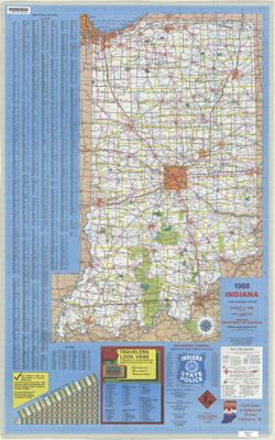
- Subject:
- Geographic Subject: Indiana and Topical Subject: Roads
- Creator:
- Indiana. Department of Highways. Division of Program Development
- Publisher:
- Indiana. Department of Highways.
- Date Created:
- 1988
- Identifier:
- VAC3073-M-01213
- Genre:
- Road maps
- Geographic Location:
- Coordinates: W0880500 W0844700 N0414500 N0374600
- Related URL:
- Catalog URL: https://iucat.iu.edu/catalog/18406100
- Abstract:
- Panel title: Indiana, 1988. Relief shown by spot heights. Includes index, distance chart, directory of state police locations, indexed list of state recreati...
- Call Number:
- G1403 .S7 1988
- Caption:
- Imprint: [Indianapolis] : Indiana Department of Highways, [1988]
- Physical Description:
- Scale: Approximately 1:633,600 and Dimensions: 94 x 59 cm
- Alternate Identifier:
- Title Control Number: a18406100
- Persistent URL:
- https://purl.dlib.indiana.edu/iudl/images/VAC3073/VAC3073-M-01213
- Provenance:
- Indiana state highway system
-
- Subject:
- Geographic Subject: Northwest, Old and Geographic Subject: Northeastern States
- Creator:
- Morse, Jedidiah, 1761-1826, Hill, Samuel, approximately 1766-1804, and Thomas & Andrews
- Publisher:
- Geological Survey (U.S.)
- Date Created:
- 1988
- Identifier:
- VAC3073-M-00979
- Genre:
- Early maps
- Geographic Location:
- Coordinates: W1030000 W0800000 N0503000 N0363000
- Related URL:
- Catalog URL: https://iucat.iu.edu/catalog/18454609
- Abstract:
- S. Hill. sc. Map dated 1796. Relief shown by hachures and pictorially. Prime meridians: Philadelphia & London. "The dotted Squares, are the Reservat...
- Call Number:
- QH75 .A4 No. 1200-IN
- Caption:
- Imprint: [Reston, Va.] : [U.S. Gelogical Survey], [1988]
- Physical Description:
- Scale: Scale not given. and Dimensions: xxv, 477 p. : ill., maps, 29 cm.
- Alternate Identifier:
- Title Control Number: a18454609 and Alternate ID: 358171IP
- Persistent URL:
- https://purl.dlib.indiana.edu/iudl/images/VAC3073/VAC3073-M-00979
- Provenance:
- The National gazetteer of the United States of America--Indiana, 1988 / U.S. Geological Survey.
-
- Subject:
- Geographic Subject: Virginia, Geographic Subject: United States, and Topical Subject: Indians of North America
- Creator:
- Sabin, Joseph, 1821-1881 and Washington, George, 1732-1799
- Publisher:
- Geological Survey (U.S.)
- Date Created:
- 1988
- Identifier:
- VAC3073-M-00372
- Genre:
- Early maps
- Geographic Location:
- Coordinates: W0923500 W0750000 N0440000 N0360000
- Related URL:
- Catalog URL: https://iucat.iu.edu/catalog/18454608
- Abstract:
- Variant tile: Map of the western parts of the colony of Virginia, as far as the Mississippi. Relief shown pictorially. Prime meridians: London and Ferro. &qu...
- Call Number:
- QH75 .A4 No. 1200-IN
- Caption:
- Imprint: [Reston, Va.] : [U.S. Geological Survey], [1988]
- Physical Description:
- Scale: Scale not given. and Dimensions: 29 cm or smaller
- Alternate Identifier:
- Alternate ID: 358171IP and Title Control Number: a18454608
- Persistent URL:
- https://purl.dlib.indiana.edu/iudl/images/VAC3073/VAC3073-M-00372
- Provenance:
- Map of the Western parts of the Colony of Virginia as far as the Mississipi.
-
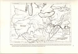
- Subject:
- Geographic Subject: Middle West
- Creator:
- Carey, Mathew, 1760-1839
- Publisher:
- Geological Survey (U.S.)
- Date Created:
- 1988
- Identifier:
- VAC3073-M-00315
- Genre:
- Early maps and Facsimiles
- Geographic Location:
- Coordinates: W0960000 W0810000 N0500000 N0360000
- Related URL:
- Catalog URL: https://iucat.iu.edu/catalog/18416533
- Abstract:
- Relief shown by hachures. Prime meridians: London and Philadelphia. Reprint of: The Upper territories of the United States. In General atlas of the world and...
- Call Number:
- QH75 .A4 No. 1200-IN
- Caption:
- Imprint: [Reston, Va.] : [The Survey], [1988]
- Physical Description:
- Dimensions: 29 cm or less and Scale: Indeterminable
- Alternate Identifier:
- Title Control Number: a18416533 and Alternate ID: 358171IP
- Persistent URL:
- https://purl.dlib.indiana.edu/iudl/images/VAC3073/VAC3073-M-00315
- Provenance:
- The National gazetteer of the United States of America--Indiana, 1988 / U.S. Geological Survey.
-
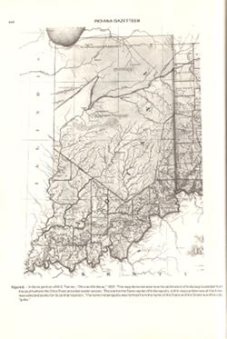
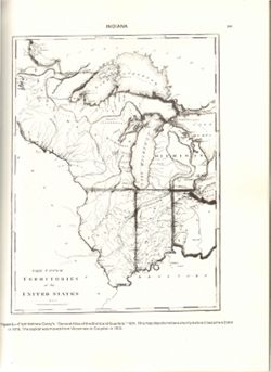
- Subject:
- Topical Subject: Potawatomi Tribe, Geographic Subject: Indiana, and Topical Subject: Kickapoo Tribe of Indians
- Creator:
- Tanner, Henry Schenck, 1786-1858
- Publisher:
- Geological Survey (U.S.)
- Date Created:
- 1988
- Identifier:
- VAC3073-M-00296
- Genre:
- Maps
- Geographic Location:
- Coordinates: W0880558 W0842342 N0414540 N0374618
- Related URL:
- Catalog URL: https://iucat.iu.edu/catalog/18454603
- Abstract:
- Title from caption. Statement of responsibility from caption. Shows areas of Indiana held by the Potawatomi and Kickapoo tribes. "Figure 6.--Indiana por...
- Call Number:
- QE75 .A4 No. 1200-IN
- Caption:
- Imprint: [Reston, Va.] : [U.S. Geological Survey], [1988]
- Physical Description:
- Scale: Indeterminable and Dimensions: 29 cm or smaller
- Alternate Identifier:
- Title Control Number: a18454603 and Alternate ID: 358171IP
- Persistent URL:
- https://purl.dlib.indiana.edu/iudl/images/VAC3073/VAC3073-M-00296
- Provenance:
- The National gazetteer of the United States of America--Indiana, 1988 / U.S. Geological Survey.
-

- Subject:
- Geographic Subject: Monroe County (Ind.), Geographic Subject: Ellettsville (Ind.), Topical Subject: Indiana University, Bloomington, Geographic Subject: Indi...
- Creator:
- Merchant Maps (Firm)
- Publisher:
- Merchant Maps (Firm)
- Date Created:
- 1988
- Identifier:
- VAC3073-M-00130
- Genre:
- Maps
- Geographic Location:
- Coordinates: W0864108 W0861902 N0392120 N0385926
- Related URL:
- Catalog URL: https://iucat.iu.edu/catalog/5298605
- Abstract:
- Includes advertisements and indexes to city and campus maps.
- Call Number:
- G4093.M7 1988 .M4
- Caption:
- Imprint: Cincinnati, Ohio : Mass Marketing Inc., Merchant Maps Division, [1988]
- Physical Description:
- Dimensions: 87 x 56 cm or smaller, sheet 59 x 89 cm and Scale: Scale not given.
- Alternate Identifier:
- Title Control Number: a5298605
- Persistent URL:
- https://purl.dlib.indiana.edu/iudl/images/VAC3073/VAC3073-M-00130
-
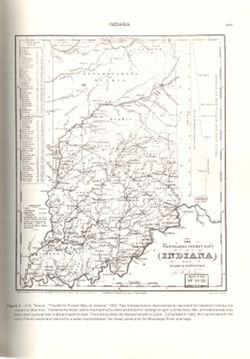
- Subject:
- Topical Subject: Potawatomi Tribe, Geographic Subject: Indiana, Topical Subject: Miami Tribe, Topical Subject: Transportation, Topical Subject: Rivers, and G...
- Creator:
- Tanner, Henry Schenck, 1786-1858
- Publisher:
- Geological Survey (U.S.)
- Date Created:
- 1988
- Identifier:
- VAC3073-M-00095
- Genre:
- Tourist maps, Geological cross-sections, and Maps
- Geographic Location:
- Coordinates: W0880500 W0834600 N0415000 N0374600
- Related URL:
- Catalog URL: https://iucat.iu.edu/catalog/18437130
- Abstract:
- Variant title: Travellers pocket map of Indiana with its roads and distances. Relief shown by profile. Shows existing and proposed canals and railroads as we...
- Call Number:
- QH75 .A4 No. 1200-IN
- Caption:
- Imprint: ©18 April, 1831, Imprint: Philadelphia : H.S. Tanner, 18 April, 1831, and Imprint: [Reston, Va.] : [U.S. Geological Survey], [1988]
- Physical Description:
- Scale: Indeterminable. Vertical scale indeterminable and Dimensions: 29 cm or smaller
- Alternate Identifier:
- Alternate ID: 358171IP and Title Control Number: a18437130
- Persistent URL:
- https://purl.dlib.indiana.edu/iudl/images/VAC3073/VAC3073-M-00095
- Provenance:
- The National gazetteer of the United States of America--Indiana, 1988 / U.S. Geological Survey.
-
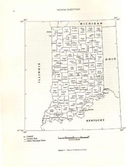
- Subject:
- Topical Subject: Counties, Geographic Subject: Indiana, and Topical Subject: Administrative and political divisions
- Creator:
- Geological Survey (U.S.)
- Publisher:
- Geological Survey (U.S.)
- Date Created:
- 1988
- Identifier:
- VAC3073-M-00025
- Genre:
- Maps
- Geographic Location:
- Coordinates: W0890000 W0840000 N0420000 N0373000
- Related URL:
- Catalog URL: https://iucat.iu.edu/catalog/18428209
- Abstract:
- At head of caption title: "Figure 1." Appears as Figure 1 in Indiana Gazetteer produced by the U.S.G.S. Professional Paper 1200-I. "The Nation...
- Call Number:
- QE75 .A4 No. 1200-IN
- Caption:
- Imprint: [Reston, Va.] : [The Survey], [1988]
- Physical Description:
- Dimensions: 29 cm or smaller and Scale: Approximately 1:3,200,000
- Alternate Identifier:
- Title Control Number: a18428209 and Alternate ID: 358171IP
- Persistent URL:
- https://purl.dlib.indiana.edu/iudl/images/VAC3073/VAC3073-M-00025
- Provenance:
- The National gazetteer of the United States of America--Indiana, 1988 / U.S. Geological Survey.
-
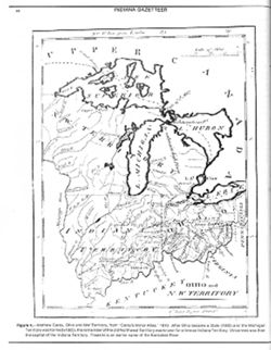
- Subject:
- Geographic Subject: Northwest, Old and Geographic Subject: Ohio
- Creator:
- Barker, W. (William), active 1795-1803 and Carey, Mathew, 1760-1839
- Publisher:
- Geological Survey (U.S.)
- Date Created:
- 1988
- Identifier:
- VAC3073-M-00004
- Genre:
- Early maps and Facsimiles
- Geographic Location:
- Coordinates: W0921900 W0794100 N0490000 N0374200
- Related URL:
- Catalog URL: https://iucat.iu.edu/catalog/18416531
- Abstract:
- Other title: Ohio and Northwest Territory. Prime meridians: London and Philadelphia. Reprint of: Ohio and N. W. Territory. In Carey's minor atlas / Carey...
- Call Number:
- QH75 .A4 No. 1200-IN
- Caption:
- Imprint: [Reston, Va.] : [The Survey], [1988]
- Physical Description:
- Scale: Indeterminable and Dimensions: 29 cm or smaller
- Alternate Identifier:
- Title Control Number: a18416531 and Alternate ID: 358171IP
- Persistent URL:
- https://purl.dlib.indiana.edu/iudl/images/VAC3073/VAC3073-M-00004
- Provenance:
- The National gazetteer of the United States of America--Indiana, 1988 / U.S. Geological Survey.
