
Search Constraints
« Previous |
1 - 20 of 940
|
Next »
Search Results
-
![Indiana Porter quadrangle [1950 reprint]](https://iiif.uits.iu.edu/iiif/2/v692v944q%2Ffiles%2Fb084bc69-a329-42a5-a2f8-741c2958c149/full/250,/0/default.jpg)
- Subject:
- Geographic Subject: Lake County (Ind.) and Geographic Subject: Porter County (Ind.)
- Creator:
- Geological Survey (U.S.) and Clement, S. E. (Stephen Earl), 1894-1981
- Publisher:
- Geological Survey (U.S.)
- Date Created:
- 1950
- Identifier:
- VAC3073-M-01380
- Genre:
- Quadrangle maps, 15 minute topographic maps, and Topographic maps
- Geographic Location:
- Coordinates: W0871500 W0870000 N0414500 N0413000
- Related URL:
- Catalog URL: https://iucat.iu.edu/catalog/18416370
- Abstract:
- Filing title: Porter, Ind. Edition of 1940. Polyconic projection. Relief shown by contours and spot heights. Contour interval 10 feet. Surveyed in 1934. Repr...
- Call Number:
- G4090 s62 .G4 Porter 1940 rep 1950
- Caption:
- Imprint: Washington, D.C. : U.S. Dept. of the Interior, Geological Survey, 1950
- Physical Description:
- Dimensions: 45 x 42 cm or smaller and Scale: 1:62,500
- Alternate Identifier:
- Title Control Number: a18416370
- Persistent URL:
- https://purl.dlib.indiana.edu/iudl/images/VAC3073/VAC3073-M-01380
- Provenance:
- Part of Geological Survey (U.S.). Indiana 1:62,500.
-
![Indiana-Kentucky Owensboro quadrangle [1950 reprint]](https://iiif.uits.iu.edu/iiif/2/dn39z555q%2Ffiles%2F89bb7d7d-8ace-46e8-8ef0-e69211350ab1/full/250,/0/default.jpg)
- Subject:
- Geographic Subject: Spencer County (Ind.), Geographic Subject: Warrick County (Ind.), and Geographic Subject: Daviess County (Ky.)
- Creator:
- Hawkins, Geo. T. (George T.), Renshawe, John H., Geological Survey (U.S.), and Cooke, Chas. E. (Charles E.)
- Publisher:
- Geological Survey (U.S.)
- Date Created:
- 1950
- Identifier:
- VAC3073-M-01376
- Genre:
- Quadrangle maps, 15 minute topographic maps, and Topographic maps
- Geographic Location:
- Coordinates: W0871500 W0870000 N0380000 N0374500
- Related URL:
- Catalog URL: https://iucat.iu.edu/catalog/18413576
- Abstract:
- John H. Renshaw, geographer in charge , control by George T. Hawkins , topography by Chas. E. Cooke. Filing title: Owensboro, Ind.-Ky. Edition of Nov. 1901. ...
- Call Number:
- G4090 s62 .G4 Owensboro 1901 rep 1950
- Caption:
- Imprint: Washington, D.C. : U.S. Geological Survey, 1950
- Physical Description:
- Scale: 1:62,500 and Dimensions: 45 x 42 cm or smaller
- Alternate Identifier:
- Title Control Number: a18413576
- Persistent URL:
- https://purl.dlib.indiana.edu/iudl/images/VAC3073/VAC3073-M-01376
- Provenance:
- Part of Geological Survey (U.S.). Indiana 1:62,500.
-
![Franklin Quadrangle Indiana : 15 minute series (topographic) [1950 printing without vegetation]](https://iiif.uits.iu.edu/iiif/2/gq67kv050%2Ffiles%2F1b2dc3c9-fa67-4787-9ad0-8c7dd5aad08b/full/250,/0/default.jpg)
- Subject:
- Geographic Subject: Brown County (Ind.), Geographic Subject: Bartholomew County (Ind.), and Geographic Subject: Johnson County (Ind.)
- Creator:
- Geological Survey (U.S.) and United States. Army. Corps of Engineers
- Publisher:
- Geological Survey (U.S.)
- Date Created:
- 1950
- Identifier:
- VAC3073-M-01330
- Genre:
- Quadrangle maps, Photogrammetric maps, Topographic maps, and 15 minute topographic maps
- Geographic Location:
- Coordinates: W0861500 W0860000 N0393000 N0391500
- Related URL:
- Catalog URL: https://iucat.iu.edu/catalog/18412610
- Abstract:
- Filing title: Franklin, Ind. Mapped, edited, and published by Geological Survey. Edition of 1950. Polyconic projection. Relief shown by contours and spot hei...
- Call Number:
- G4090 s62 .G4 Franklin 1950
- Caption:
- Imprint: Washington, D.C. : Interior--Geological Survey, [1950]
- Physical Description:
- Dimensions: 45 x 42 cm or smaller and Scale: 1:62,500
- Alternate Identifier:
- Title Control Number: a18412610
- Persistent URL:
- https://purl.dlib.indiana.edu/iudl/images/VAC3073/VAC3073-M-01330
- Provenance:
- Part of Geological Survey (U.S.). Indiana 1:62,500.
-
![Franklin Quadrangle Indiana : 15 minute series (topographic) [1950 printing with vegetation]](https://iiif.uits.iu.edu/iiif/2/s1785q21n%2Ffiles%2F2980480d-4dc3-4d46-8d25-f5ccac9e74ef/full/250,/0/default.jpg)
- Subject:
- Geographic Subject: Brown County (Ind.), Geographic Subject: Bartholomew County (Ind.), Geographic Subject: Johnson County (Ind.), and Topical Subject: Veget...
- Creator:
- Geological Survey (U.S.) and United States. Army. Corps of Engineers
- Publisher:
- Geological Survey (U.S.)
- Date Created:
- 1950
- Identifier:
- VAC3073-M-01329
- Genre:
- Topographic maps, Photogrammetric maps, 15 minute topographic maps, and Quadrangle maps
- Geographic Location:
- Coordinates: W0861500 W0860000 N0393000 N0391500
- Related URL:
- Catalog URL: https://iucat.iu.edu/catalog/18412610
- Abstract:
- Filing title: Franklin, Ind. Mapped, edited, and published by Geological Survey. Edition of 1950. Polyconic projection. Relief shown by contours and spot hei...
- Call Number:
- G4090 s62 .G4 Franklin 1950 V
- Caption:
- Imprint: Washington, D.C. : Interior--Geological Survey, [1950]
- Physical Description:
- Scale: 1:62,500 and Dimensions: 45 x 42 cm or smaller
- Alternate Identifier:
- Title Control Number: a18412610
- Persistent URL:
- https://purl.dlib.indiana.edu/iudl/images/VAC3073/VAC3073-M-01329
- Provenance:
- Part of Geological Survey (U.S.). Indiana 1:62,500.
-
![Edinburg Quadrangle Indiana : 15 minute series (topographic) [1950 printing with vegetation]](https://iiif.uits.iu.edu/iiif/2/4b29c880r%2Ffiles%2F58f84ee1-c680-40d2-9a78-baf3613c076f/full/250,/0/default.jpg)
- Subject:
- Geographic Subject: Johnson County (Ind.), Geographic Subject: Shelby County (Ind.), Geographic Subject: Bartholomew County (Ind.), and Topical Subject: Vege...
- Creator:
- Geological Survey (U.S.) and United States. Army. Corps of Engineers
- Publisher:
- Geological Survey (U.S.)
- Date Created:
- 1950
- Identifier:
- VAC3073-M-01291
- Genre:
- Topographic maps, Quadrangle maps, 15 minute topographic maps, and Photogrammetric maps
- Geographic Location:
- Coordinates: W0860000 W0854500 N0393000 N0391500
- Related URL:
- Catalog URL: https://iucat.iu.edu/catalog/18412275
- Abstract:
- Filing title: Edinburg, Ind. Edition of 1950. Polyconic projection. Relief shown by contours and spot heights. Contour interval 20 feet. Shows Shelby County,...
- Call Number:
- G4090 s62 .G4 Edinburg 1950 V
- Caption:
- Imprint: Washington, D.C. : Geological Survey, [1950]
- Physical Description:
- Dimensions: 45 x 42 cm or smaller and Scale: 1:62,500
- Alternate Identifier:
- Title Control Number: a18412275
- Persistent URL:
- https://purl.dlib.indiana.edu/iudl/images/VAC3073/VAC3073-M-01291
- Provenance:
- Part of Geological Survey (U.S.). Indiana 1:62,500.
-
![Edinburg Quadrangle Indiana : 15 minute series (topographic) [1950 printing without vegetation]](https://iiif.uits.iu.edu/iiif/2/3b592c294%2Ffiles%2F06928e89-6508-4c49-a4ff-7f390a205f57/full/250,/0/default.jpg)
- Subject:
- Geographic Subject: Bartholomew County (Ind.), Geographic Subject: Johnson County (Ind.), and Geographic Subject: Shelby County (Ind.)
- Creator:
- United States. Army. Corps of Engineers and Geological Survey (U.S.)
- Publisher:
- Geological Survey (U.S.)
- Date Created:
- 1950
- Identifier:
- VAC3073-M-01280
- Genre:
- Photogrammetric maps, Quadrangle maps, Topographic maps, and 15 minute topographic maps
- Geographic Location:
- Coordinates: W0860000 W0854500 N0393000 N0391500
- Related URL:
- Catalog URL: https://iucat.iu.edu/catalog/18412275
- Abstract:
- Filing title: Edinburg, Ind. Edition of 1950. Polyconic projection. Relief shown by contours and spot heights. Contour interval 20 feet. Shows Shelby County,...
- Call Number:
- G4090 s62 .G4 Edinburg 1950
- Caption:
- Imprint: Washington, D.C. : Geological Survey, [1950]
- Physical Description:
- Scale: 1:62,500 and Dimensions: 45 x 42 cm or smaller
- Alternate Identifier:
- Title Control Number: a18412275
- Persistent URL:
- https://purl.dlib.indiana.edu/iudl/images/VAC3073/VAC3073-M-01280
- Provenance:
- Part of Geological Survey (U.S.). Indiana 1:62,500.
-
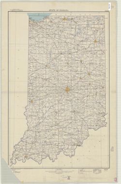
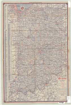
- Subject:
- Geographic Subject: Indiana
- Creator:
- Geological Survey (U.S.)
- Publisher:
- The Survey
- Date Created:
- 1950
- Identifier:
- VAC3073-M-01002
- Genre:
- Maps
- Geographic Location:
- Coordinates: W0880700 W0844500 N0414500 N0375200
- Related URL:
- Catalog URL: https://iucat.iu.edu/catalog/2251506
- Abstract:
- Title in lower right margin: Indiana, base map with highways.
- Call Number:
- G4090 1950 .G4
- Caption:
- Imprint: Washington, D.C. : The Survey, 1950.
- Physical Description:
- Dimensions: 92 x 59 cm and Scale: 1:500,000
- Alternate Identifier:
- Title Control Number: BGX7083BB
- Persistent URL:
- https://purl.dlib.indiana.edu/iudl/images/VAC3073/VAC3073-M-01002
-
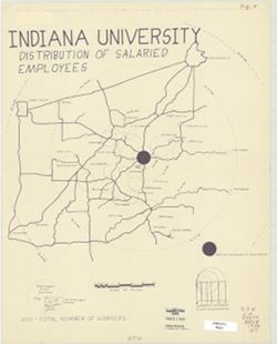
- Subject:
- Geographic Subject: Monroe County (Ind.), Geographic Subject: Bloomington Region (Ind.), Geographic Subject: Indiana University, Bloomington, Topical Subject...
- Publisher:
- [publisher not identified]
- Date Created:
- 1950
- Identifier:
- VAC3073-M-00954
- Genre:
- Thematic maps
- Geographic Location:
- Coordinates: W0873300 W0855300 N0394700 N0384000
- Related URL:
- Catalog URL: https://iucat.iu.edu/catalog/5298168
- Abstract:
- Blue line print. Shows numbers of Indiana University salaried employees by home cities and towns with graduated circles. Includes graphs.
- Call Number:
- G4094.B5 G8 1950 .I5
- Caption:
- Imprint: [Place of publication not identified] : [publisher not identified], [between 1950 and 1969?]
- Physical Description:
- Scale: 1:500,000 and Dimensions: 46 x 36 cm
- Alternate Identifier:
- Title Control Number: a5298168
- Persistent URL:
- https://purl.dlib.indiana.edu/iudl/images/VAC3073/VAC3073-M-00954
-
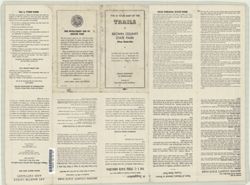
- Subject:
- Geographic Subject: Brown County State Park (Ind.), Geographic Subject: Indiana, and Topical Subject: Trails
- Creator:
- Indiana. Division of State Parks, Lands, and Waters
- Publisher:
- Indiana. Division of State Parks, Lands, and Waters
- Date Created:
- 1950
- Identifier:
- VAC3073-M-00860
- Genre:
- Tourist maps
- Geographic Location:
- Coordinates: W0861349 W0861339 N0390851 N0390842
- Related URL:
- Catalog URL: https://iucat.iu.edu/catalog/7465323
- Abstract:
- "3-50--120M:--Back panel. Includes ancillary map "Detail map of the trails in the day use area" (scale approximately 12,500), location map and...
- Call Number:
- G4092.B73 1950 .I5
- Caption:
- Imprint: [Indianapolis?] : Indiana Department of Conservation, Division of State Parks, Lands, and Waters, [1950]
- Physical Description:
- Dimensions: 37 x 28 cm, on sheet 41 x 56 cm and Scale: 1:36,000
- Alternate Identifier:
- Title Control Number: a7465323
- Persistent URL:
- https://purl.dlib.indiana.edu/iudl/images/VAC3073/VAC3073-M-00860
-
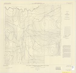
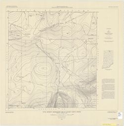
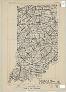
- Subject:
- Topical Subject: Geomagnetism and Geographic Subject: Dubois County (Ind.)
- Creator:
- Henderson, John R.
- Publisher:
- Geological Survey (U.S.)
- Date Created:
- 1950
- Identifier:
- VAC3073-M-00835
- Genre:
- Geological maps and Thematic maps
- Geographic Location:
- Coordinates: W0870423 W0864044 N0383135 N0381210
- Related URL:
- Catalog URL: https://iucat.iu.edu/catalog/8174197
- Abstract:
- Includes text and location map.
- Call Number:
- G4093.D8C93 1950 .H46
- Caption:
- Imprint: [Washington, D.C.] : U.S. Geological Survey, 1950.
- Physical Description:
- Scale: 1:63,360 and Dimensions: 57 x 64 cm
- Alternate Identifier:
- Title Control Number: a8174197
- Persistent URL:
- https://purl.dlib.indiana.edu/iudl/images/VAC3073/VAC3073-M-00835
-
- Subject:
- Topical Subject: Roads and Geographic Subject: Indiana
- Creator:
- H.M. Gousha Company
- Publisher:
- H.M. Gousha Company
- Date Created:
- 1950
- Identifier:
- VAC3073-M-00825
- Genre:
- Road maps
- Geographic Location:
- Coordinates: W0880500 W0844700 N0414500 N0374600
- Related URL:
- Catalog URL: https://iucat.iu.edu/catalog/5272424
- Abstract:
- Includes index to counties, cities and towns. Text, ill., Transcontinental mileage chart, and ancillary maps of Indianapolis, Indiana, and Standard Oil Co...
- Call Number:
- G4091.P2 1950 .H2
- Caption:
- Imprint: Chicago : H.M. Gousha, [1950]
- Physical Description:
- Scale: 1:760,000 and Dimensions: 66 x 41 cm
- Alternate Identifier:
- Title Control Number: a5272424
- Persistent URL:
- https://purl.dlib.indiana.edu/iudl/images/VAC3073/VAC3073-M-00825
-
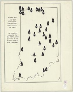
- Subject:
- Topical Subject: Sex distribution (Demography), Geographic Subject: Indiana, Topical Subject: Cities and towns, and Topical Subject: Age distribution (Demogr...
- Creator:
- Hart, John Fraser
- Publisher:
- [publisher not identified]
- Date Created:
- 1950
- Identifier:
- VAC3073-M-00746
- Genre:
- Thematic maps
- Geographic Location:
- Coordinates: W0880500 W0844700 N0414500 N0374600
- Related URL:
- Catalog URL: https://iucat.iu.edu/catalog/6086983
- Abstract:
- "JFH." "The numbers indicate the 1950 population of each place to the closest ten thousand." Includes an age-sex pyramid for each of the ...
- Call Number:
- G4091.E24 1950 .H378
- Caption:
- Imprint: [Place of publications not identified] : [publisher not identified], [195-?]
- Physical Description:
- Scale: Scale not given. and Dimensions: 64 x 45 cm
- Alternate Identifier:
- Title Control Number: a6086983
- Persistent URL:
- https://purl.dlib.indiana.edu/iudl/images/VAC3073/VAC3073-M-00746
-
- Subject:
- Geographic Subject: Lake County (Ind.), Topical Subject: Land use, Geographic Subject: Gary (Ind.), and Geographic Subject: Gary Region (Ind.)
- Creator:
- Guiney, Donald
- Publisher:
- [publisher not identified]
- Date Created:
- 1950
- Identifier:
- VAC3073-M-00712
- Genre:
- Thematic maps
- Geographic Location:
- Coordinates: W0872601 W0871319 N0413919 N0413118
- Related URL:
- Catalog URL: https://iucat.iu.edu/catalog/7314939
- Abstract:
- Title supplied by cataloger. Produced as a class project in the Indiana University, Geography Department. Land use hand colored in colored pencil. Base map: ...
- Call Number:
- G4094.G2G4 1950 .G85
- Caption:
- Imprint: [Place of publication not identified]: [publisher not identified], [195-?]
- Physical Description:
- Dimensions: 53 x 70 cm and Scale: 1:29,000
- Persistent URL:
- https://purl.dlib.indiana.edu/iudl/images/VAC3073/VAC3073-M-00712
-
- Subject:
- Geographic Subject: Elkhart County (Ind.) and Topical Subject: Geomagnetism
- Creator:
- Dempsey, W. J.
- Publisher:
- Geological Survey (U.S.)
- Date Created:
- 1950
- Identifier:
- VAC3073-M-00707
- Genre:
- Thematic maps
- Geographic Location:
- Coordinates: W0860345 W0853912 N0414537 N0412605
- Related URL:
- Catalog URL: https://iucat.iu.edu/catalog/8177225
- Abstract:
- Includes text and location map.
- Call Number:
- G4093.E4C93 1950 .D4
- Caption:
- Imprint: [Washington, D.C.] : For sale by U.S. Geological Survey, 1950.
- Physical Description:
- Dimensions: 60 x 66 cm and Scale: 1:63,500
- Alternate Identifier:
- Title Control Number: a8177225
- Persistent URL:
- https://purl.dlib.indiana.edu/iudl/images/VAC3073/VAC3073-M-00707
-
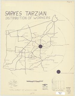
- Subject:
- Topical Subject: Labor supply, Geographic Subject: Bloomington Region (Ind.), and Geographic Subject: Indiana
- Publisher:
- [publisher not identified]
- Date Created:
- 1950
- Identifier:
- VAC3073-M-00710
- Genre:
- Thematic maps
- Geographic Location:
- Coordinates: W0864342 W0854642 N0395150 N0383133
- Related URL:
- Catalog URL: https://iucat.iu.edu/catalog/5296737
- Abstract:
- Blue line print. Shows numbers of Sarkes Tarzian employees by home cities and towns with graduated circles. Includes graphs.
- Call Number:
- G4094.B5 G8 1950 .S27
- Caption:
- Imprint: [Place of publication not identified] : [publisher not identified], [between 1950 and 1969?]
- Physical Description:
- Dimensions: 46 x 36 cm and Scale: 1:500,000
- Alternate Identifier:
- Title Control Number: a5296737
- Persistent URL:
- https://purl.dlib.indiana.edu/iudl/images/VAC3073/VAC3073-M-00710
-
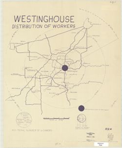
- Subject:
- Geographic Subject: Bloomington Region (Ind.), Topical Subject: Westinghouse Electric Corporation, and Topical Subject: Labor supply
- Publisher:
- publisher not identified
- Date Created:
- 1950
- Identifier:
- VAC3073-M-00615
- Genre:
- Thematic maps
- Geographic Location:
- Coordinates: W0863532 W0862816 N0391315 N0390716
- Related URL:
- Catalog URL: https://iucat.iu.edu/catalog/5296697
- Abstract:
- Blue line print. Shows numbers of Westinghouse Bloomington employees by home cities and towns with graduated circles. Includes graphs.
- Call Number:
- G4094.B5 G8 1950 .W47
- Caption:
- Imprint: [place of publication not identified : publisher not identified, between 1950 and 1969?]
- Physical Description:
- Scale: 1:500,000 and Dimensions: on sheet 46 x 37 cm
- Alternate Identifier:
- Title Control Number: a5296697
- Persistent URL:
- https://purl.dlib.indiana.edu/iudl/images/VAC3073/VAC3073-M-00615
-
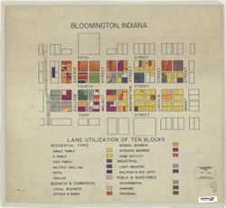
- Subject:
- Topical Subject: Land use and Geographic Subject: Bloomington (Ind.)
- Publisher:
- [publisher not identified]
- Date Created:
- 1950
- Identifier:
- VAC3073-M-00589
- Genre:
- Thematic maps
- Geographic Location:
- Coordinates: W0863206 W0863146 N0391000 N0390950
- Related URL:
- Catalog URL: https://iucat.iu.edu/catalog/5299843
- Abstract:
- Shows the area from the Monon Railroad on the west to Grant Street on the east, and from Fifth Street on the north to Third Street on the South. Pen-and-ink...
- Call Number:
- G4094.B5 G4 1950 .B5
- Caption:
- Imprint: [Place of publication not identified] : [publisher not identified], [195-?]
- Physical Description:
- Scale: Scale not given. and Dimensions: 47 x 52 cm
- Alternate Identifier:
- Title Control Number: a5299843
- Persistent URL:
- https://purl.dlib.indiana.edu/iudl/images/VAC3073/VAC3073-M-00589
-
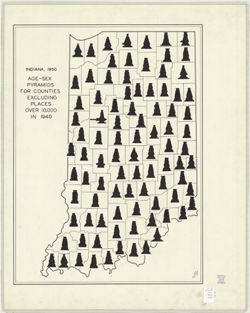
- Subject:
- Topical Subject: Age distribution (Demography), Topical Subject: Sex distribution (Demography), and Geographic Subject: Indiana
- Creator:
- Hart, John Fraser
- Publisher:
- [publisher not identified]
- Date Created:
- 1950
- Identifier:
- VAC3073-M-00337
- Genre:
- Thematic maps
- Geographic Location:
- Coordinates: W0880500 W0844700 N0414500 N0374600
- Related URL:
- Catalog URL: https://iucat.iu.edu/catalog/6083935
- Abstract:
- "JFH." Pen and ink. Includes an age-sex pyramid for each of Indiana's 92 counties. Also appeared as figure 4 in John Fraser Hart. Age pyramids ...
- Call Number:
- G4091.E24 1950 .H37
- Caption:
- Imprint: [place of publication not identified] : [publisher not identified], 1950.
- Physical Description:
- Dimensions: 62 x 45 cm and Scale: Scale not given.
- Alternate Identifier:
- Title Control Number: a6083935
- Persistent URL:
- https://purl.dlib.indiana.edu/iudl/images/VAC3073/VAC3073-M-00337
-
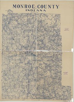
- Subject:
- Topical Subject: Landowners, Topical Subject: Real property, and Geographic Subject: Monroe County (Ind.)
- Creator:
- Stapleton, John T. (John Tracy)
- Publisher:
- [publisher not identified]
- Date Created:
- 1950
- Identifier:
- VAC3073-M-00331
- Genre:
- Cadastral maps
- Geographic Location:
- Coordinates: W0864100 W0861900 N0392100 N0390000
- Related URL:
- Catalog URL: https://iucat.iu.edu/catalog/5044576
- Abstract:
- Blue line print. Cadastral map showing landowners. "1950."
- Call Number:
- G4093.M7 G46 1950 .S73
- Caption:
- Imprint: [Bloomington, Ind.?] : [publisher not identified], 1950.
- Physical Description:
- Dimensions: 127 x 99 cm and Scale: 1:63,360
- Alternate Identifier:
- Title Control Number: a5044576
- Persistent URL:
- https://purl.dlib.indiana.edu/iudl/images/VAC3073/VAC3073-M-00331
-
- Subject:
- Geographic Subject: Indiana
- Creator:
- Geological Survey (U.S.)
- Publisher:
- Geological Survey (U.S.)
- Date Created:
- 1950
- Identifier:
- VAC3073-M-00311
- Genre:
- Thematic maps
- Geographic Location:
- Coordinates: W0880700 W0844700 N0414500 N0374600
- Related URL:
- Catalog URL: https://iucat.iu.edu/catalog/2256717
- Abstract:
- "Printed 1950"--Margin.
- Call Number:
- G4091 .A1 1950 .G4
- Caption:
- Imprint: Washington, D.C.: The Survey, 1950.
- Physical Description:
- Dimensions: 91 x 58 cm, on sheet 108 x 69 cm and Scale: 1:500,000
- Alternate Identifier:
- Title Control Number: BGY3152BB
- Persistent URL:
- https://purl.dlib.indiana.edu/iudl/images/VAC3073/VAC3073-M-00311
