
Search Constraints
You searched for:
Publisher
Geological Survey (U.S.)
Remove constraint Publisher: Geological Survey (U.S.)
Subject
Geographic Subject: Indiana
Remove constraint Subject: Geographic Subject: Indiana
1 - 8 of 8
Search Results
-
- Subject:
- Geographic Subject: Indiana
- Creator:
- Geological Survey (U.S.)
- Publisher:
- Geological Survey (U.S.)
- Date Created:
- Circa 1912
- Identifier:
- VAC3073-M-01292
- Genre:
- Maps
- Geographic Location:
- Coordinates: W0880700 W0844500 N0414500 N0375200
- Related URL:
- Catalog URL: https://iucat.iu.edu/catalog/6087422
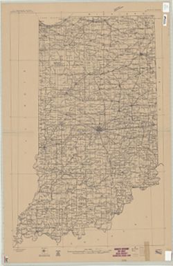
- Abstract:
- "Compiled in 1909-1910." Stamped in upper margin: "Advance sheet. Subject to correction." Includes diagram showing the "Re...
- Call Number:
- G4090 1910 .G4
- Caption:
- Imprint: [Washington, D.C.] : U.S. Geological Survey, [1912?]
- Physical Description:
- Dimensions: 92 x 60 cm and Scale: 1:500,000
- Persistent URL:
- https://purl.dlib.indiana.edu/iudl/images/VAC3073/VAC3073-M-01292
-
- Subject:
- Geographic Subject: Indiana
- Creator:
- Geological Survey (U.S.)
- Publisher:
- Geological Survey (U.S.)
- Date Created:
- 1914
- Identifier:
- VAC3073-M-01290
- Genre:
- Topographic maps
- Geographic Location:
- Coordinates: W0880700 W0844500 N0414500 N0375200
- Related URL:
- Catalog URL: https://iucat.iu.edu/catalog/11839670
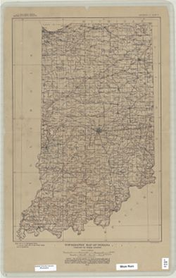
- Abstract:
- Relief shown by contours. Contour interval 100 feet. "Base from U.S. Geological Survey 1:1,000,000 scale map of the United States now in prep...
- Call Number:
- G4090 1914 .G4
- Caption:
- Imprint: [Washington, D.C.] : U.S. Geological Survey, 1914
- Physical Description:
- Dimensions: 46 x 31 cm and Scale: 1:1,000,000
- Persistent URL:
- https://purl.dlib.indiana.edu/iudl/images/VAC3073/VAC3073-M-01290
-
- Subject:
- Topical Subject: Geology and Geographic Subject: Indiana
- Creator:
- Geological Survey (U.S.)
- Publisher:
- Geological Survey (U.S.)
- Date Created:
- 1925
- Identifier:
- VAC3073-M-00756
- Genre:
- Index maps
- Geographic Location:
- Coordinates: W0880000 W0850000 N0413000 N0374500
- Related URL:
- Catalog URL: No Record at this time
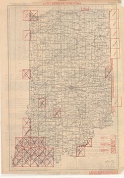
- Abstract:
- "April 1, 1925." "Order maps by names printed in red. No others are published." Text on verso
- Call Number:
- G4091.A2 1925 .G46
- Caption:
- Imprint: Washington, D.C. : U.S. Geological Survey, [1925]
- Physical Description:
- Scale: 1:1,000,000 and Dimensions: 47 x 41 cm
- Persistent URL:
- https://purl.dlib.indiana.edu/iudl/images/VAC3073/VAC3073-M-00756
-
- Subject:
- Geographic Subject: Indiana and Topical Subject: Maps
- Creator:
- Geological Survey (U.S.)
- Publisher:
- Geological Survey (U.S.)
- Date Created:
- 1973
- Identifier:
- VAC3073-M-00367
- Genre:
- Topographic maps
- Geographic Location:
- Coordinates: W0880700 W0844500 N0414500 N0374600
- Related URL:
- Catalog URL: https://iucat.iu.edu/catalog/13903794
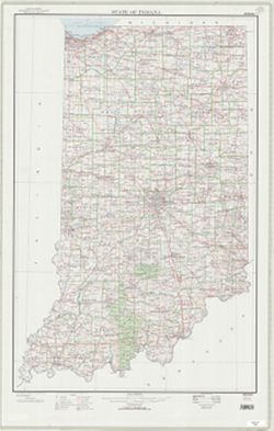
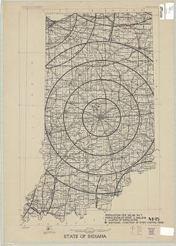
- Abstract:
- Compiled in 1970. Includes population key. Source data U.S. Dept. of the Interior - Geological Survey topographic maps. U.S. Dept of the Army - Corps of Engi...
- Call Number:
- G4091.C2 1973 .G4
- Caption:
- Imprint: [Reston, Va.] : U.S. Geological Survey, 1973
- Physical Description:
- Dimensions: 91 x 59 cm and Scale: 1:500,000
- Alternate Identifier:
- Title Control Number: a5297954
- Persistent URL:
- https://purl.dlib.indiana.edu/iudl/images/VAC3073/VAC3073-M-00367
-
- Subject:
- Geographic Subject: Indiana
- Creator:
- Geological Survey (U.S.)
- Publisher:
- Geological Survey (U.S.)
- Date Created:
- 1950
- Identifier:
- VAC3073-M-00311
- Genre:
- Thematic maps
- Geographic Location:
- Coordinates: W0880700 W0844700 N0414500 N0374600
- Related URL:
- Catalog URL: https://iucat.iu.edu/catalog/2256717
- Abstract:
- "Printed 1950"--Margin.
- Call Number:
- G4091 .A1 1950 .G4
- Caption:
- Imprint: Washington, D.C.: The Survey, 1950.
- Physical Description:
- Dimensions: 91 x 58 cm, on sheet 108 x 69 cm and Scale: 1:500,000
- Alternate Identifier:
- Title Control Number: BGY3152BB
- Persistent URL:
- https://purl.dlib.indiana.edu/iudl/images/VAC3073/VAC3073-M-00311
-
- Subject:
- Topical Subject: Potawatomi Tribe, Geographic Subject: Indiana, and Topical Subject: Kickapoo Tribe of Indians
- Creator:
- Tanner, Henry Schenck, 1786-1858
- Publisher:
- Geological Survey (U.S.)
- Date Created:
- 1988
- Identifier:
- VAC3073-M-00296
- Genre:
- Maps
- Geographic Location:
- Coordinates: W0880558 W0842342 N0414540 N0374618
- Related URL:
- Catalog URL: https://iucat.iu.edu/catalog/18454603
- Abstract:
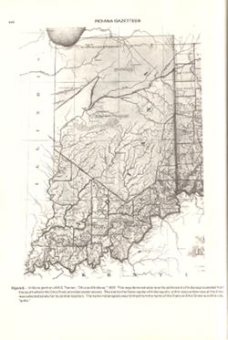
- Title from caption. Statement of responsibility from caption. Shows areas of Indiana held by the Potawatomi and Kickapoo tribes. "Figure 6.--Indiana por...
- Call Number:
- QE75 .A4 No. 1200-IN
- Caption:
- Imprint: [Reston, Va.] : [U.S. Geological Survey], [1988]
- Physical Description:
- Scale: Indeterminable and Dimensions: 29 cm or smaller
- Alternate Identifier:
- Title Control Number: a18454603 and Alternate ID: 358171IP
- Persistent URL:
- https://purl.dlib.indiana.edu/iudl/images/VAC3073/VAC3073-M-00296
- Provenance:
- The National gazetteer of the United States of America--Indiana, 1988 / U.S. Geological Survey.
-
- Subject:
- Topical Subject: Potawatomi Tribe, Geographic Subject: Indiana, Topical Subject: Miami Tribe, Topical Subject: Transportation, Topical Subject: Rivers, and G...
- Creator:
- Tanner, Henry Schenck, 1786-1858
- Publisher:
- Geological Survey (U.S.)
- Date Created:
- 1988
- Identifier:
- VAC3073-M-00095
- Genre:
- Tourist maps, Geological cross-sections, and Maps
- Geographic Location:
- Coordinates: W0880500 W0834600 N0415000 N0374600
- Related URL:
- Catalog URL: https://iucat.iu.edu/catalog/18437130
- Abstract:
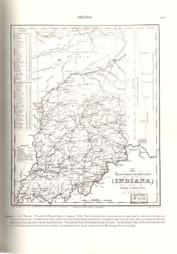
- Variant title: Travellers pocket map of Indiana with its roads and distances. Relief shown by profile. Shows existing and proposed canals and railroads as we...
- Call Number:
- QH75 .A4 No. 1200-IN
- Caption:
- Imprint: ©18 April, 1831, Imprint: Philadelphia : H.S. Tanner, 18 April, 1831, and Imprint: [Reston, Va.] : [U.S. Geological Survey], [1988]
- Physical Description:
- Scale: Indeterminable. Vertical scale indeterminable and Dimensions: 29 cm or smaller
- Alternate Identifier:
- Alternate ID: 358171IP and Title Control Number: a18437130
- Persistent URL:
- https://purl.dlib.indiana.edu/iudl/images/VAC3073/VAC3073-M-00095
- Provenance:
- The National gazetteer of the United States of America--Indiana, 1988 / U.S. Geological Survey.
-
- Subject:
- Topical Subject: Counties, Geographic Subject: Indiana, and Topical Subject: Administrative and political divisions
- Creator:
- Geological Survey (U.S.)
- Publisher:
- Geological Survey (U.S.)
- Date Created:
- 1988
- Identifier:
- VAC3073-M-00025
- Genre:
- Maps
- Geographic Location:
- Coordinates: W0890000 W0840000 N0420000 N0373000
- Related URL:
- Catalog URL: https://iucat.iu.edu/catalog/18428209
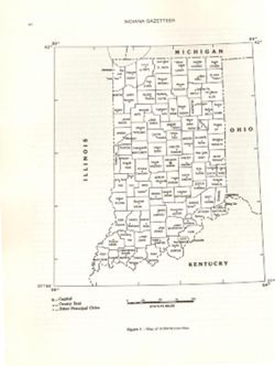
- Abstract:
- At head of caption title: "Figure 1." Appears as Figure 1 in Indiana Gazetteer produced by the U.S.G.S. Professional Paper 1200-I. "The Nation...
- Call Number:
- QE75 .A4 No. 1200-IN
- Caption:
- Imprint: [Reston, Va.] : [The Survey], [1988]
- Physical Description:
- Dimensions: 29 cm or smaller and Scale: Approximately 1:3,200,000
- Alternate Identifier:
- Title Control Number: a18428209 and Alternate ID: 358171IP
- Persistent URL:
- https://purl.dlib.indiana.edu/iudl/images/VAC3073/VAC3073-M-00025
- Provenance:
- The National gazetteer of the United States of America--Indiana, 1988 / U.S. Geological Survey.
