
Search Constraints
You searched for:
Publisher
Indiana. Department of Geology and Natural Resources
Remove constraint Publisher: Indiana. Department of Geology and Natural Resources
« Previous |
1 - 20 of 196
|
Next »
Search Results
-
- Subject:
- Geographic Subject: Richmond (Ind.), Topical Subject: IGS Annual Reports, Geographic Subject: Madison (Ind.), Topical Subject: Stratigraphic correlation, Top...
- Creator:
- Cumings, E. R. (Edgar Roscoe), 1874-1967
- Publisher:
- Indiana. Department of Geology and Natural Resources
- Date Created:
- 1908
- Identifier:
- VAC3073-M-00056
- Genre:
- Charts and Geological cross-sections
- Geographic Location:
- Coordinates: W0852400 W0844800 N0395000 N0384000
- Related URL:
- Catalog URL: https://iucat.iu.edu/catalog/18298808
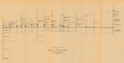
- Abstract:
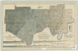
- Includes 17 stratigraphic columns and correlation lines. Detached from: The stratigraphy and paleontology of the Cincinnati series of Indiana / E.R. Cumin...
- Call Number:
- G4091.C57 1908 .C86
- Caption:
- Imprint: [Indianapolis] : [Wm. B. Burford], [1908] and Imprint: [Indianapolis] : [Indiana Department of Geology and Natural Resources], [1908]
- Physical Description:
- Dimensions: on sheet 32 x 60 cm and Scale: Scale not given.
- Alternate Identifier:
- Title Control Number: a18298808 and Alternate ID: 390726IP
- Persistent URL:
- https://purl.dlib.indiana.edu/iudl/images/VAC3073/VAC3073-M-00056
- Provenance:
- 32nd Annual Report (1907) / Indiana. Department of Geology and Natural Resources.
-
- Subject:
- Topical Subject: IGS Annual Reports, Topical Subject: Mines and mineral resources, Topical Subject: Road materials, and Geographic Subject: Monroe County (Ind.)
- Publisher:
- Indiana. Department of Geology and Natural Resources
- Date Created:
- 1906
- Identifier:
- VAC3073-M-01160
- Genre:
- Geological maps
- Geographic Location:
- Coordinates: W0864107 W0861903 N0392122 N0385936
- Related URL:
- Catalog URL: https://iucat.iu.edu/catalog/18299087
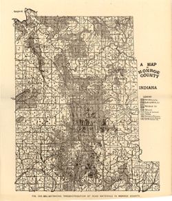
- Abstract:
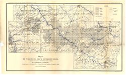
- Alternate title: Illustrating the distribution of road materials in Monroe County. At head of alternate title: Fig. 53B. Shows roads, limestone, gravel, sand...
- Call Number:
- G4093.M7H5 1905 .M3
- Caption:
- Imprint: [Indianapolis] : [Indiana Dept. of Geology and Natural Resources], [1906]
- Physical Description:
- Scale: Approximately 1:171,000 and Dimensions: 26 x 22 cm
- Alternate Identifier:
- Alternate ID: 390726IP and Title Control Number: a18299087
- Persistent URL:
- https://purl.dlib.indiana.edu/iudl/images/VAC3073/VAC3073-M-01160
- Provenance:
- 30th Annual Report (1905) / Indiana. Department of Geology and Natural Resources.
-
- Subject:
- Geographic Subject: Greene County (Ind.) and Topical Subject: Soils
- Creator:
- Tharp, W. E. (William Edgar)
- Publisher:
- Indiana. Department of Geology and Natural Resources
- Date Created:
- 1912
- Identifier:
- VAC3073-M-01159
- Genre:
- Thematic maps
- Geographic Location:
- Coordinates: W0871427 W0864055 N0391018 N0385408
- Related URL:
- Catalog URL: https://iucat.iu.edu/catalog/16151513
- Abstract:
- Detached from: Soil survey of Greene County (1901) / by W. E. Tharp and Charles J. Mann, of the U. S. Bureau of Soils. In Thirty-sixth annual report of Depar...
- Call Number:
- G4093.G7J3 1906 .T5
- Caption:
- Imprint: [Indianapolis] : State of Indiana, Department of Geology, [1912] [Indianapolis] : [Wm. B. Burford], [1912]
- Physical Description:
- Dimensions: 35 x 52 cm and Scale: 1:80,000
- Alternate Identifier:
- Title Control Number: a16151513 and Alternate ID: 390726IP
- Persistent URL:
- https://purl.dlib.indiana.edu/iudl/images/VAC3073/VAC3073-M-01159
- Provenance:
- 36th Annual Report (1911) / Indiana. Department of Geology and Natural Resources.
-
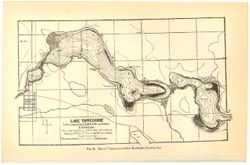
- Subject:
- Topical Subject: Lakes, Topical Subject: IGS Annual Reports, Geographic Subject: Tippecanoe, Lake (Ind.), and Geographic Subject: Kosciusko County (Ind.)
- Creator:
- Mase, Thomas L.
- Publisher:
- Indiana. Department of Geology and Natural Resources
- Date Created:
- 1901
- Identifier:
- VAC3073-M-01170
- Genre:
- Bathymetric maps
- Related URL:
- Catalog URL: https://iucat.iu.edu/catalog/4022271
- Call Number:
- QE109 .A2 1900 map p186
- Caption:
- Imprint: Indianapolis : Burford, 1901.
- Physical Description:
- Dimensions: 15 x 23 cm
- Persistent URL:
- https://purl.dlib.indiana.edu/iudl/images/VAC3073/VAC3073-M-01170
- Provenance:
- 25th Annual Report (1900) / Indiana. Department of Geology and Natural Resources.
-
- Subject:
- Geographic Subject: Perry County (Ind.), Geographic Subject: Spencer County (Ind.), Topical Subject: Coal, and Geographic Subject: Warrick County (Ind.)
- Creator:
- Ashley, Geo. H. (George Hall), 1866-1951, Kindle, E. M. (Edward Martin), 1869-1940, and Price, J. A.
- Publisher:
- Indiana. Department of Geology and Natural Resources
- Date Created:
- 1898
- Identifier:
- VAC3073-M-01185
- Genre:
- Geological maps
- Geographic Location:
- Coordinates: W0872823 W0862942 N0381446 N0374639
- Related URL:
- Catalog URL: https://iucat.iu.edu/catalog/9160352
- Abstract:
- By George H. Ashley, assistant geologist, Department of Geology and Natural Resources of Indiana, W.S. Blatchley, state geologist , geology by G.H. Ashley, J...
- Call Number:
- G4093.W4H9 1898 .A8
- Caption:
- Imprint: Indianapolis : Burford, [1899] and Imprint: [Indianapolis, Ind.] : Dept. of Geology and Natural Resources of Indiana, [1899]
- Physical Description:
- Dimensions: 46 x 76 cm and Scale: 1:31,680
- Persistent URL:
- https://purl.dlib.indiana.edu/iudl/images/VAC3073/VAC3073-M-01185
- Provenance:
- 23rd Annual Report (1898) / Indiana. Department of Geology and Natural Resources.
-
- Subject:
- Geographic Subject: Indiana, Topical Subject: Gas fields, Topical Subject: Petroleum, and Topical Subject: IGS Annual Reports
- Creator:
- Ashley, Geo. H. (George Hall), 1866-1951
- Publisher:
- Indiana. Department of Geology and Natural Resources
- Date Created:
- 1897
- Identifier:
- VAC3073-M-01153
- Genre:
- Geological maps
- Geographic Location:
- Coordinates: W0854200 W0845200 N0404600 N0402300
- Related URL:
- Catalog URL: https://iucat.iu.edu/catalog/17188279
- Abstract:
- To accompany the report on the petroleum industry in Indiana by W.S. Blatchley, state geologist : annual report of the Department of Geology and Natural Reso...
- Call Number:
- G4091.H8 1896 .A8
- Caption:
- Imprint: [Indianapolis] : Department of Geology and Natural Resources of Indiana, [1897]
- Physical Description:
- Dimensions: 35 x 60 cm and Scale: Approximately 1:126,720. 2 miles = 1 inch
- Alternate Identifier:
- Title Control Number: a17188279 and Alternate ID: 390726IP
- Persistent URL:
- https://purl.dlib.indiana.edu/iudl/images/VAC3073/VAC3073-M-01153
- Provenance:
- 21st Annual Report (1896) / Indiana. Department of Geology and Natural Resources.
-
- Subject:
- Geographic Subject: Monroe County (Ind.), Geographic Subject: Greene County (Ind.), Geographic Subject: Indiana, Geographic Subject: Owen County (Ind.), and ...
- Publisher:
- Indiana. Department of Geology and Natural Resources
- Date Created:
- 1915
- Identifier:
- VAC3073-M-01188
- Genre:
- Quadrangle maps, Topographic maps, and Geological maps
- Geographic Location:
- Coordinates: W0864500 W0863000 N0391500 N0390000
- Related URL:
- Catalog URL: https://iucat.iu.edu/catalog/16190483
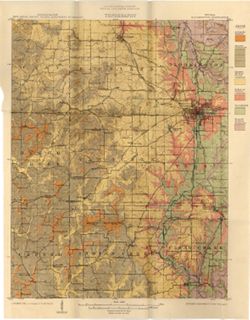
- Abstract:
- Relief shown by contours and spot heights. Contour interval 20 feet. Shows limestone locations in a portion of Monroe County and small portions of Owen and G...
- Call Number:
- G4093.M7C5 1914 .I6
- Caption:
- Imprint: [Indianapolis] : Indiana Dept. of Geology [and Natural Resources], [1915] and Imprint: [Indianapolis] : [Wm. B. Burford], [1915]
- Physical Description:
- Scale: 1:62,500 and Dimensions: 45 x 35 cm
- Alternate Identifier:
- Title Control Number: a16190483 and Alternate ID: 390726IP
- Persistent URL:
- https://purl.dlib.indiana.edu/iudl/images/VAC3073/VAC3073-M-01188
- Provenance:
- 39th Annual Report (1914) / Indiana. Department of Geology and Natural Resources.
-
- Subject:
- Topical Subject: Soils and Geographic Subject: Carroll County (Ind.)
- Creator:
- Erni, C. P. (Chester Prall), 1896- and Beals, C. C.
- Publisher:
- Indiana. Department of Geology and Natural Resources
- Date Created:
- 1917
- Identifier:
- VAC3073-M-01476
- Genre:
- Thematic maps
- Geographic Location:
- Coordinates: W0864600 W0862200 N0404400 N0402600
- Related URL:
- Catalog URL: https://iucat.iu.edu/catalog/15734020
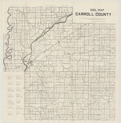
- Abstract:
- Detached from: Carroll County / C.P. Erni and C.C. Beals. In Forty-first annual report of Dept. of Geology and Natural Resources, Indiana, 1916. Fort Wayne, ...
- Call Number:
- G4093.C2J3 1916 .E7
- Caption:
- Imprint: [Indianapolis] : Ind. Dept. of Geology, [1917]
- Physical Description:
- Scale: Approximately 1:63,630. 1 in. = 1 mile and Dimensions: 57 x 57 cm
- Alternate Identifier:
- Title Control Number: a15734020
- Persistent URL:
- https://purl.dlib.indiana.edu/iudl/images/VAC3073/VAC3073-M-01476
- Provenance:
- 41st Annual Report (1916) / Indiana. Department of Geology and Natural Resources.
-
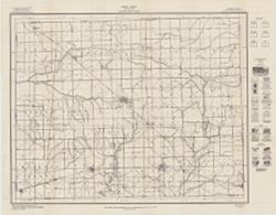
- Subject:
- Topical Subject: Geology, Topical Subject: IGS Annual Reports, Topical Subject: Mines and mineral resources, and Geographic Subject: Benton County (Ind.)
- Creator:
- Jones, Grove B., 1877- and Brill, J. Bayard
- Publisher:
- Indiana. Department of Geology and Natural Resources
- Date Created:
- 1917
- Identifier:
- VAC3073-M-01478
- Genre:
- Thematic maps
- Related URL:
- Catalog URL: https://iucat.iu.edu/catalog/4022271
- Abstract:
- From page 29 of the 41st Annual Report.
- Call Number:
- QE109 .A2 1916
- Caption:
- Imprint: Indianapolis : 1917.
- Persistent URL:
- https://purl.dlib.indiana.edu/iudl/images/VAC3073/VAC3073-M-01478
- Provenance:
- 41st Annual Report (1916) / Indiana. Department of Geology and Natural Resources.
-
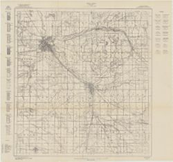
- Subject:
- Geographic Subject: Elkhart County (Ind.), Topical Subject: Mines and mineral resources, Topical Subject: Geology, and Topical Subject: IGS Annual Reports
- Creator:
- Jones, Grove B., 1877- and Hesler, R. S.
- Publisher:
- Indiana. Department of Geology and Natural Resources
- Date Created:
- 1915
- Identifier:
- VAC3073-M-01474
- Genre:
- Thematic maps
- Related URL:
- Catalog URL: https://iucat.iu.edu/catalog/4022271
- Call Number:
- QE109 .A2 1914
- Caption:
- Imprint: Indianapolis : 1915
- Persistent URL:
- https://purl.dlib.indiana.edu/iudl/images/VAC3073/VAC3073-M-01474
- Provenance:
- 39th Annual Report (1914) / Indiana. Department of Geology and Natural Resources.
-
- Subject:
- Topical Subject: Gravel, Geographic Subject: Indiana, Topical Subject: IGS Annual Reports, and Topical Subject: Road materials
- Publisher:
- Indiana. Department of Geology and Natural Resources
- Date Created:
- 1906
- Identifier:
- VAC3073-M-00646
- Genre:
- Thematic maps and Geological maps
- Geographic Location:
- Coordinates: W0873100 W0844800 N0413000 N0403400
- Related URL:
- Catalog URL: https://iucat.iu.edu/catalog/18299084
- Abstract:
- Alternate title: Illustrating the distribution of road materials in northern Indiana. At head of alternate title: Fig. 23. Shows areas of abundant, scarce, a...
- Call Number:
- G4091.H5 1905 .M3
- Caption:
- Imprint: [Indianapolis] : [Indiana Dept. of Geology and Natural Resources], [1906]
- Physical Description:
- Scale: Scale not given. and Dimensions: on sheet 17 x 26 cm
- Alternate Identifier:
- Title Control Number: a18299084 and Alternate ID: 390726IP
- Persistent URL:
- https://purl.dlib.indiana.edu/iudl/images/VAC3073/VAC3073-M-00646
- Provenance:
- 30th Annual Report (1905) / Indiana. Department of Geology and Natural Resources.
-
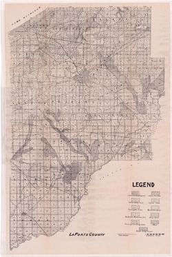
- Subject:
- Topical Subject: IGS Annual Reports, Topical Subject: Soils, Geographic Subject: LaPorte County (Ind.), and Topical Subject: Soil surveys
- Publisher:
- Indiana. Department of Geology and Natural Resources
- Date Created:
- 1912
- Identifier:
- VAC3073-M-01082
- Genre:
- Thematic maps
- Geographic Location:
- Coordinates: W0865600 W0862910 N0414539 N0411412
- Related URL:
- Catalog URL: https://iucat.iu.edu/catalog/16131280
- Abstract:
- Variant title: La Porte County. Shows soil types, dirt roads, improved roads, and railroads. Detached from: Soil survey of Laporte County / E.J. Quinn. In...
- Call Number:
- G4093.L15J3 1911 .L37
- Caption:
- Imprint: [Indianapolis] : [Wm. B. Burford], [1912] and Imprint: [Indianapolis] : [Department of Geology and Natural Resources, Indiana], [1912]
- Physical Description:
- Dimensions: on sheet 70 x 46 cm
- Alternate Identifier:
- Title Control Number: a16131280 and Alternate ID: 390726IP
- Persistent URL:
- https://purl.dlib.indiana.edu/iudl/images/VAC3073/VAC3073-M-01082
- Provenance:
- 36th Annual Report (1911) / Indiana. Geological Survey.
-

- Subject:
- Geographic Subject: Clay County (Ind.), Topical Subject: Coal, Geographic Subject: Putnam County (Ind.), Topical Subject: IGS Annual Reports, Geographic Subj...
- Creator:
- Ashley, Geo. H. (George Hall), 1866-1951, Siebenthal, C. E. (Claude Ellsworth), 1869-1930, and Scovell, J. T. (Josiah Thomas), 1841-
- Publisher:
- Indiana. Department of Geology and Natural Resources
- Date Created:
- 1899
- Identifier:
- VAC3073-M-00899
- Genre:
- Geological maps and Geological cross-sections
- Geographic Location:
- Coordinates: W0873635 W0864028 N0393634 N0390856
- Related URL:
- Catalog URL: https://iucat.iu.edu/catalog/18259650
- Abstract:
- Relief shown by spot heights. Includes map showing coal locations and features, railroads, and quarries as well as vertical cross sections for Dana to Portla...
- Call Number:
- G4093.V5H9 1898 .A84
- Caption:
- Imprint: Indianapolis, Ind. : Wm. B. Burford, [1899]
- Physical Description:
- Scale: Approximately 1:126,720. 2 miles = 1 inch and Dimensions: 48 x 77 cm
- Alternate Identifier:
- Alternate ID: 390726IP and Title Control Number: a18259650
- Persistent URL:
- https://purl.dlib.indiana.edu/iudl/images/VAC3073/VAC3073-M-00899
- Provenance:
- 23rd Annual Report (1898) / Indiana. Department of Geology and Natural Resources.
-
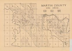
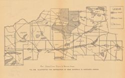
- Subject:
- Geographic Subject: Martin County (Ind.), Topical Subject: IGS Annual Reports, and Topical Subject: Iron ores
- Publisher:
- Indiana. Department of Geology and Natural Resources
- Date Created:
- 1907
- Identifier:
- VAC3073-M-00898
- Genre:
- Geological maps
- Geographic Location:
- Coordinates: W0865526 W0864056 N0385428 N0382940
- Related URL:
- Catalog URL: https://iucat.iu.edu/catalog/18299172
- Abstract:
- Detached from: The iron ore deposits of Indiana / Charles W. Shannon. In Indiana Dept. of Geology and Natural Resources thirty-first annual report, 1906. Ind...
- Call Number:
- G4093.M5H2 1907 .M3
- Caption:
- Imprint: [Indianapolis] : [Indiana Dept. of Geology and Natural Resources], [1907] and Imprint: [Indianapolis] : [Wm. B. Burford], [1907]
- Physical Description:
- Scale: Approximately 1:59,000 and Dimensions: on sheet 27 x 37 cm
- Alternate Identifier:
- Alternate ID: 390726IP and Title Control Number: a18299172
- Persistent URL:
- https://purl.dlib.indiana.edu/iudl/images/VAC3073/VAC3073-M-00898
- Provenance:
- 31st Annual Report (1906) / Indiana. Department of Geology and Natural Resources.
-
![Township 2 south, range 7 west [Indiana]](https://iiif.uits.iu.edu/iiif/2/2b88rf889%2Ffiles%2F8503c6af-2a95-4ca4-acde-dcd4736a0d0c/full/250,/0/default.jpg)
- Subject:
- Topical Subject: Coal reserves, Geographic Subject: Pike County (Ind.), Topical Subject: Geology, Stratigraphic, and Topical Subject: IGS Annual Reports
- Publisher:
- Indiana. Department of Geology and Natural Resources
- Date Created:
- 1899
- Identifier:
- VAC3073-M-00614
- Genre:
- Geological cross-sections and Geological maps
- Geographic Location:
- Coordinates: W0871432 W0870735 N0382243 N0381721
- Related URL:
- Catalog URL: http://www.iucat.iu.edu/catalog/18418128
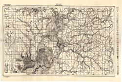
- Abstract:
- Relief shown by profile. Other title from Bureau of Land Management database: IN T2S R7W. 20 columnar sections showing coal measures and location map for unn...
- Call Number:
- G4093.P4H9 1898 .T6
- Caption:
- Imprint: [Indianapolis] : [Wm. B. Burford], [1899] and Imprint: [Indianapolis] : [Indiana, Dept. of Geology and Natural History], [1899]
- Physical Description:
- Dimensions: 23 x 27 cm and Scale: Approximately 1:63,360. Vertical scale not given
- Alternate Identifier:
- Title Control Number: a18418128 and Alternate ID: 390726IP
- Persistent URL:
- https://purl.dlib.indiana.edu/iudl/images/VAC3073/VAC3073-M-00614
- Provenance:
- 23rd Annual Report (1898) / Indiana. Department of Geology and Natural Resources.
-
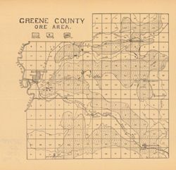
- Subject:
- Geographic Subject: Greene County (Ind.), Topical Subject: Iron ores, and Topical Subject: IGS Annual Reports
- Publisher:
- Indiana. Department of Geology and Natural Resources
- Date Created:
- 1907
- Identifier:
- VAC3073-M-00949
- Genre:
- Geological maps
- Geographic Location:
- Coordinates: W0871431 W0864053 N0391018 N0385418
- Related URL:
- Catalog URL: https://iucat.iu.edu/catalog/18299136
- Abstract:
- Detached from: The iron ore deposits of Indiana / Charles W. Shannon. In Indiana Dept. of Geology and Natural Resources thirty-first annual report, 1906. Ind...
- Call Number:
- G4093.G7H2 1907 .G7
- Caption:
- Imprint: [Indianapolis] : [Indiana Dept. of Geology and Natural Resources], [1907] and Imprint: [Indianapolis] : [Wm. B. Burford], [1907]
- Physical Description:
- Dimensions: on sheet 23 x 24 cm and Scale: Approximately 1:130,000
- Alternate Identifier:
- Alternate ID: 390726IP and Title Control Number: a18299136
- Persistent URL:
- https://purl.dlib.indiana.edu/iudl/images/VAC3073/VAC3073-M-00949
- Provenance:
- 31st Annual Report (1906) / Indiana. Department of Geology and Natural Resources.
-
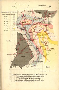
- Subject:
- Topical Subject: Geology, Geographic Subject: Indiana, Topical Subject: IGS Annual Reports, Topical Subject: Minerals, and Topical Subject: Trenton Limestone
- Creator:
- Cubberley, Ellwood P., 1868-1941
- Publisher:
- Indiana. Department of Geology and Natural Resources
- Date Created:
- 1894
- Identifier:
- VAC3073-M-01555
- Genre:
- Geological maps and Index maps
- Geographic Location:
- Coordinates: W0880500 W0844700 N0414500 N0374600
- Related URL:
- Catalog URL: https://iucat.iu.edu/catalog/18224941
- Abstract:
- Relation of Trenton rock to sea level shown with shading and contour lines. Map showing paths of the geological cross sections depicted in the illustrations ...
- Call Number:
- G4091.C57 1893 .C83
- Caption:
- Imprint: Indpls : lithographed by William B. Burford, [1894] and Imprint: [Indianapolis] : [Indiana, Dept. of Geology and Natural Resources], [1894]
- Physical Description:
- Scale: Scale not given. and Dimensions: 15 x 23 cm
- Alternate Identifier:
- Title Control Number: a18224941 and Alternate ID: 390726IP
- Persistent URL:
- https://purl.dlib.indiana.edu/iudl/images/VAC3073/VAC3073-M-01555
- Provenance:
- 18th Annual Report (1893) / Indiana. Department of Geology and Natural Resources.
-
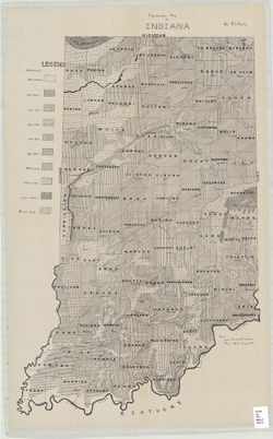
- Subject:
- Geographic Subject: Indiana and Topical Subject: IGS Annual Reports
- Creator:
- Hesler, R. S.
- Publisher:
- Indiana. Department of Geology and Natural Resources
- Date Created:
- 1913
- Identifier:
- VAC3073-M-01536
- Genre:
- Topographic maps
- Geographic Location:
- Coordinates: W0880500 W0844700 N0414500 N0374600
- Related URL:
- Catalog URL: https://iucat.iu.edu/catalog/18466085
- Abstract:
- Relief shown by choropleth methods. "Note: Data--railroad elevations, Plan--after Leverett." Detached from: Topography of Indiana--Map / Edward ...
- Call Number:
- G4091.C2 1913 .H4
- Caption:
- Imprint: [Indianapolis] : [Indiana Department of Geology and Natural Resources], [1913]
- Physical Description:
- Dimensions: on sheet 73 x 46 cm and Scale: Scale not given.
- Alternate Identifier:
- Alternate ID: 390726IP and Title Control Number: a18466085
- Persistent URL:
- https://purl.dlib.indiana.edu/iudl/images/VAC3073/VAC3073-M-01536
- Provenance:
- 37th Annual Report (1912) / Indiana. Department of Geology and Natural Resources.
-
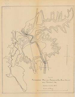
- Subject:
- Geographic Subject: Owen County (Ind.), Geographic Subject: Eel River Valley (Ind. : Valley), Topical Subject: IGS Annual Reports, and Topical Subject: Valleys
- Publisher:
- Indiana. Department of Geology and Natural Resources
- Date Created:
- 1911
- Identifier:
- VAC3073-M-00830
- Genre:
- Topographic maps
- Geographic Location:
- Coordinates: W0865003 W0864726 N0392725 N0392513
- Related URL:
- Catalog URL: https://iucat.iu.edu/catalog/18418393
- Abstract:
- Relief shown by contours. Contour interval 20 feet. Shows upper falls dam and proposed lower falls dams now located within the Cataract Falls State Recreatio...
- Call Number:
- G4092.O8C2 1910 .T6
- Caption:
- Imprint: [Indianapolis] : [Wm. B. Burford], [1911] and Imprint: [Indianapolis] : [Indiana Department of Geology and Natural Resources], [1911]
- Physical Description:
- Scale: Approximately 1:7,650 and Dimensions: 31 x 25 cm
- Alternate Identifier:
- Title Control Number: a18418393 and Alternate ID: 390726IP
- Persistent URL:
- https://purl.dlib.indiana.edu/iudl/images/VAC3073/VAC3073-M-00830
- Provenance:
- 35th Annual Report (1910) / Indiana. Department of Geology and Natural Resources.
-
- Subject:
- Topical Subject: Roads, Topical Subject: IGS Annual Reports, and Geographic Subject: Monroe County (Ind.)
- Publisher:
- Indiana. Department of Geology and Natural Resources
- Date Created:
- 1906
- Identifier:
- VAC3073-M-00037
- Genre:
- Road maps
- Geographic Location:
- Coordinates: W0864107 W0861811 N0392126 N0385936
- Related URL:
- Catalog URL: https://iucat.iu.edu/catalog/18298783
- Abstract:
- Shows roads, improved roads, rural routes, rail roads, and road metal quarries. Alternate title: Illustrating the roads of Monroe County. At head of alternat...
- Call Number:
- G4093.M7P2 1905 .R6
- Caption:
- Imprint: Indianapolis : 1906
- Physical Description:
- Scale: Approximately 1:130,000 and Dimensions: 36 x 27 cm
- Alternate Identifier:
- Alternate ID: 390726IP and Title Control Number: a18298783
- Persistent URL:
- https://purl.dlib.indiana.edu/iudl/images/VAC3073/VAC3073-M-00037
- Provenance:
- 30th Annual Report (1905) / Indiana. Department of Geology and Natural Resources.
