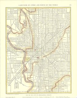
From Bradford, T.G., A comprehensive atlas, geographical, historical & commercial. Boston : American Stationers' Co., 1835. Shows state and county ...
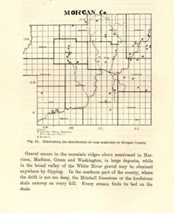
Alternate title: Morgan Co. Title from caption. At head of title: Fig. 45. Detached from: The roads and road materials of a portion of southwestern Indian...
Call Number:
G4093.M9H5 1905 .M67
Caption:
Imprint: [Indianapolis] : [Indiana Dept. of Geology and Natural Resources], [1906]
Physical Description:
Scale: Approximately 1:366,300 and Dimensions: on sheet 17 x 14 cm
Alternate Identifier:
Alternate ID: 390726IP and Title Control Number: a18299115
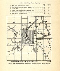
Shows locations of clay deposits and local brick and tile companies. Also includes listings of measurements for the Bockting Bros.' clay pit. "Fig....
Call Number:
G4094.H8H5 1904 .M37
Caption:
Imprint: [Indianapolis] : [Wm. B. Burford], [1905] and Imprint: [Indianapolis] : [Indiana Department of Geology and Natural Resources], [1905]
Physical Description:
Scale: Approximately 1:46,650 and Dimensions: on sheet 17 x 14 cm
Alternate Identifier:
Alternate ID: 390726IP and Title Control Number: a18282191
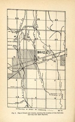
Title from caption. "Fig. 8." "RSB DEL." Shows locations of clay deposits as well as mining, clay works, brick, and sewer pipe companies....
Call Number:
G4093.P2H5 1904 .B75
Caption:
Imprint: [Indianapolis] : [Wm. B. Burford], [1905] and Imprint: [Indianapolis] : [Indiana Department of Geology and Natural Resources], [1905]
Physical Description:
Scale: Approximately 1:46,650 and Dimensions: on sheet 22 x 14 cm
Alternate Identifier:
Title Control Number: a18279473 and Alternate ID: 390726IP
Geographic Subject: Bridgeton Region (Ind.), Topical Subject: Mines and mineral resources, Geographic Subject: Parke County (Ind.), Topical Subject: IGS Annu...
Publisher:
Indiana. Department of Geology and Natural Resources
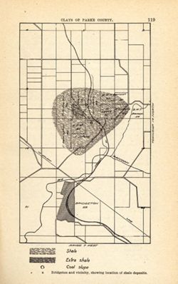
Shows location of shale, extra shale, and coal slope. "Clays of Parke County." Detached from: The clays and clay industries of Indiana / W. S. B...
Call Number:
G4093.P2H5 1904 .B75
Caption:
Imprint: [Indianapolis] : [Indiana Department of Geology and Natural Resources], [1905] and Imprint: [Indianapolis] : [Wm. B. Burford], [1905]
Physical Description:
Scale: Scale not given. and Dimensions: on sheet 22 x 14 cm
Alternate Identifier:
Alternate ID: 390726IP and Title Control Number: a18279221
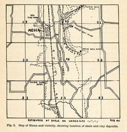
Title from caption. Shows locations of shale and clay deposits, clay mines, and local brick and clay works companies. Also includes listing of measurements f...
Call Number:
G4093.P2H5 1904 .M37
Caption:
Imprint: [Indianapolis] : [Indiana Department of Geology and Natural Resources ], [1905] and Imprint: [Indianapolis] : [Wm. B. Burford], [1905]
Physical Description:
Dimensions: on sheet 12 x 12 cm and Scale: Approximately 1:46,650
Alternate Identifier:
Alternate ID: 390726IP and Title Control Number: a18282202
Relief shown by contours and profile. Shows location of dams on Winona Lake outlet near Warsaw in Kosciusko County, Indiana, and cross-sections of upper and ...
Call Number:
G4093.K6N2 1903 .M3
Caption:
Imprint: [Indianapolis] : [Wm. B. Burford], [1904] and Imprint: [Indianapolis] : [Indiana Department of Geology and Natural Resources], [1904]
Physical Description:
Dimensions: on sheet 10 x 10 cm and Scale: Approximately 1:20,100. Vertical scale varies
Alternate Identifier:
Title Control Number: a18418357 and Alternate ID: 390726IP
Shows states and principal cities indexed in margin. Inset maps show Hamburg and Berlin. Shows cities, towns, and railroads. "Copyright, 1911, by P....
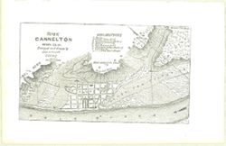
Relief shown by hachures. From Indiana gazetteer, or topographical dictionary of the state of Indiana. Indianapolis : E. Chamberlain, 1850. Shows Cannelt...

![Map No. 4 showing locations of upper & lower dams [Winona Lake Region, Indiana]](https://iiif.uits.iu.edu/iiif/2/3j3345867%2Ffiles%2Fcfcf70eb-0483-44d3-b9ee-e305909b40f2/full/250,/0/default.jpg)