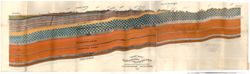
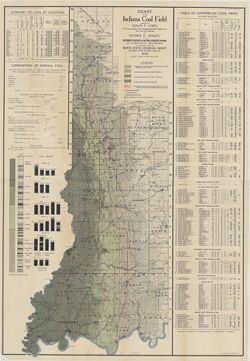
Includes twenty-four columnar sections showing coal measurements and three statistical tables: Table of commercial coal mines -- Summary of coal by counties ...
Call Number:
G4091.H5 1909 .L56
Caption:
Imprint: Indianapolis : Department of Geology and Natural Resources of Indiana, 1909
Physical Description:
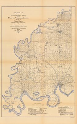
Dimensions: 125 x 60 cm and Scale: 1:253,440. Vertical scales differ
Geographic Subject: Perry County (Ind.), Geographic Subject: Spencer County (Ind.), Topical Subject: Coal, and Geographic Subject: Warrick County (Ind.)
Creator:
Ashley, Geo. H. (George Hall), 1866-1951, Kindle, E. M. (Edward Martin), 1869-1940, and Price, J. A.
Publisher:
Indiana. Department of Geology and Natural Resources
Date Created:
1898
Identifier:
VAC3073-M-01185
Genre:
Geological maps
Geographic Location:
Coordinates: W0872823 W0862942 N0381446 N0374639
Related URL:
Catalog URL: https://iucat.iu.edu/catalog/9160352
Abstract:
By George H. Ashley, assistant geologist, Department of Geology and Natural Resources of Indiana, W.S. Blatchley, state geologist , geology by G.H. Ashley, J...
Call Number:
G4093.W4H9 1898 .A8
Caption:
Imprint: Indianapolis : Burford, [1899] and Imprint: [Indianapolis, Ind.] : Dept. of Geology and Natural Resources of Indiana, [1899]
By Prof. E. T. Cox, Prof Leo Lesquereux. Title derived from caption titles. Includes 3 sections showing coal measures. No. 3. Connected section of coal measu...
Call Number:
G4091.H9 1870 .C69
Caption:
Imprint: [Indianapolis] : [Geological Survey of Indiana], [1871]
Physical Description:
Dimensions: 21 x 23 cm and Scale: Scale not given.
Alternate Identifier:
Title Control Number: a18308391 and Alternate ID: 390721IP
Geological cross section. Relief shown by profile. Detached from: First annual report of the Geological Survey of Indiana ... 1869. Indianapolis : Alexand...
Call Number:
G4091.C57 1869 .L4
Caption:
Imprint: [Indianapolis] : [Alexander M. Conner], [1869] and Imprint: [Indianapolis] : [Geological Survey of Indiana], 1869
Physical Description:
Dimensions: 34 x 117 cm and Scale: Approximately 1:95,040. 1 1/2 miles to 1 in. Vertical scale approximately 1:2,400. 200 ft. to 1 in.
Topical Subject: Mines and mineral resources, Topical Subject: Geology, Topical Subject: IGS Annual Reports, Geographic Subject: Perry County (Ind.), and Top...
Publisher:
Indiana. Department of Geology and Natural Resources
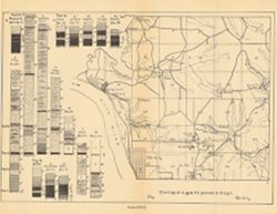
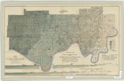
Relief shown by spot heights. Includes map showing the location of coal locations, coal features, and railroads, as well as geological cross sections for sev...
Call Number:
G4093.S8H9 1898 .A84
Caption:
Imprint: Indianapolis, Ind. : Wm. B. Burford, [1899]
Physical Description:
Scale: Approximately 1:126,720. 2 miles = 1 inch. Vertical scale approximately 1:4,800. 1 inch = 400 feet and Dimensions: 48 x 78 cm
Alternate Identifier:
Alternate ID: 390726IP and Title Control Number: a18265344
Relief shown by spot heights. Includes map showing coal locations and features, and quarries as well as vertical cross-sections through center of Township 3 ...
Call Number:
G4093.P4H9 1898 .A84
Caption:
Imprint: Indianapolis : Burford, [1899]
Physical Description:
Dimensions: 48 x 78 cm and Scale: Approximately 1:126,720. 1 inch = 2 miles. Vertical scale approximately 1:4,800. 1 inch = 400 feet
Alternate Identifier:
Title Control Number: a18175917 and Alternate ID: 390726IP
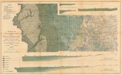
Relief shown by profile. Shows two geological cross-sections. "Based upon Congressional land surveys, field work of Ind. Geol. Survey, county atlases.&q...
Call Number:
G4093.W4H9 1898 .A8x
Caption:
Imprint: Indianapolis : Burford, [1899] and Imprint: [Indianapolis, Ind.] : Dept. of Geology and Natural Resources of Indiana, [1899]
Physical Description:
Scale: Approximately 1:126,720. 2 miles = 1 inch. Vertical scale approximately 1:4,800. 400 feet = 1 inch and Dimensions: 49 x 77 cm
Alternate Identifier:
Alternate ID: 390726IP and Title Control Number: a16848969
Relief shown by spot heights. "Based upon[:] B. F. & Co.'s Atlas of Indiana, 1876. Lake's Atlas of Gibson and Pike Counties, 1881. F. C. H. ...
Call Number:
QE109 .A2 1898 map p1408
Caption:
Imprint: Indianapolis, Ind. : Wm. B. Burford, [1899]
Physical Description:
Scale: Approximately 1:126,720. 2 miles = 1 inch and Dimensions: 78 x 48 cm
Alternate Identifier:
Title Control Number: a18188198 and Alternate ID: 390726IP
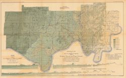
Relief shown by spot heights. Includes map showing coal locations and features, railroads, and quarries as well as vertical cross sections for Dana to Portla...
Call Number:
G4093.V5H9 1898 .A84
Caption:
Imprint: Indianapolis, Ind. : Wm. B. Burford, [1899]
Physical Description:
Scale: Approximately 1:126,720. 2 miles = 1 inch and Dimensions: 48 x 77 cm
Alternate Identifier:
Alternate ID: 390726IP and Title Control Number: a18259650


![[Coal measure sections in Indiana, Southern Illinois, and Western Kentucky]](https://iiif.uits.iu.edu/iiif/2/bz60f023f%2Ffiles%2F64b4d7e0-2da2-4574-93ae-d19cd0523815/full/250,/0/default.jpg)