
Search Constraints
You searched for:
Campus
IUB
Remove constraint Campus: IUB
Date Created
1912
Remove constraint Date Created: 1912
Holding Location
B-WELLS
Remove constraint Holding Location: B-WELLS
Collections
Indiana Historic Maps
Remove constraint Collections: Indiana Historic Maps
Pages
0-99 pages
Remove constraint Pages: 0-99 pages
« Previous |
1 - 10 of 26
|
Next »
Search Results
-
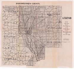
- Subject:
- Geographic Subject: Bartholomew County (Ind.) and Topical Subject: Soils
- Creator:
- Indiana. Department of Geology and Natural Resources
- Publisher:
- Indiana. Department of Geology and Natural Resources
- Date Created:
- 1912
- Identifier:
- VAC3073-M-01088
- Genre:
- Thematic maps
- Geographic Location:
- Coordinates: W0860508 W0854104 N0392100 N0390209
- Related URL:
- Catalog URL: https://iucat.iu.edu/catalog/16136919
- Abstract:
- Shows roads and railroads. Detached from: Soil survey of Bartholomew County / E.J. Quinn. In Thirty-sixth annual report of Department of Geology and Natur...
- Call Number:
- G4093.B3J3 1911 .I53
- Caption:
- Imprint: [Indianapolis] : [Department of Geology and Natural Resources], [1912] and Imprint: [Indianapolis] : [Wm. B. Burford], [1912]
- Physical Description:
- Dimensions: 40 x 41 cm, on sheet 44 x 49 cm and Scale: Approximately 1:85,000
- Alternate Identifier:
- Alternate ID: 390726IP and Title Control Number: a16136919
- Persistent URL:
- https://purl.dlib.indiana.edu/iudl/images/VAC3073/VAC3073-M-01088
- Provenance:
- 36th Annual Report (1911) / Indiana. Department of Geology and Natural Resources.
-
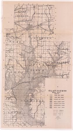
- Subject:
- Topical Subject: IGS Annual Reports, Geographic Subject: Clay County (Ind.), and Topical Subject: Soils
- Creator:
- Shannon, M. E. and Shannon, C. W. (Charles William), 1879-1934
- Publisher:
- Indiana. Department of Geology and Natural Resources
- Date Created:
- 1912
- Identifier:
- VAC3073-M-01093
- Genre:
- Thematic maps
- Related URL:
- Catalog URL: https://iucat.iu.edu/catalog/4022271
- Abstract:
- Detached from: Soil survey of Clay, Knox, Sullivan and Vigo counties / by Charles W. Shannon. In Thirty-sixth annual report of Department of Geology and Natu...
- Call Number:
- QE109 .A2 1911 map p170
- Caption:
- Imprint: [Indianapolis] : [Department of Geology and Natural Resources, Indiana], [1912] [Indianapolis] : [Wm. B. Burford], [1912]
- Physical Description:
- Scale: Approximately 1:63,360 and Dimensions: 80 x 45 cm
- Alternate Identifier:
- Title Control Number: 390726IP
- Persistent URL:
- https://purl.dlib.indiana.edu/iudl/images/VAC3073/VAC3073-M-01093
- Provenance:
- 36th Annual Report (1911) / Indiana. Department of Geology and Natural Resources.
-
- Subject:
- Geographic Subject: Scott County (Ind.) and Topical Subject: Soils
- Creator:
- Mangum, A. W. and Neill, N. P. (Nelson Prentice)
- Publisher:
- [Department of Geology and Natural Resources]
- Date Created:
- 1912
- Identifier:
- VAC3073-M-01083
- Genre:
- Thematic maps
- Geographic Location:
- Coordinates: W0855318 W0853411 N0384954 N0383340
- Related URL:
- Catalog URL: https://iucat.iu.edu/catalog/16137083
- Abstract:
- Shows roads and railroads. Detached from: Soil survey of Scott County, Indiana / A.W. Mangum and N.P. Neill. In Thirty-sixth annual report of Department o...
- Call Number:
- G4093.S3J3 1911 .M3
- Caption:
- Imprint: [Indianapolis] : [Department of Geology and Natural Resources], [1912] and Imprint: [Indianapolis] : [Wm. B. Burford],[1912]
- Physical Description:
- Dimensions: 48 x 45 cm and Scale: Approximately 1:63,360
- Alternate Identifier:
- Title Control Number: a16137083 and Alternate ID: 390726IP
- Persistent URL:
- https://purl.dlib.indiana.edu/iudl/images/VAC3073/VAC3073-M-01083
- Provenance:
- 36th Annual Report (1911) / Indiana. Department of Geology and Natural Resources.
-
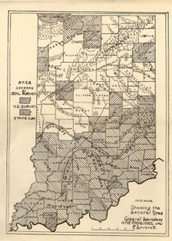
- Subject:
- Topical Subject: Soil surveys, Geographic Subject: Indiana, Topical Subject: IGS Annual Reports, Topical Subject: Moraines, and Topical Subject: Glacial epoch
- Publisher:
- Indiana. Department of Geology and Natural Resources
- Date Created:
- 1912
- Identifier:
- VAC3073-M-01144
- Genre:
- Thematic maps and Index maps
- Geographic Location:
- Coordinates: W0880500 W0844700 N0414500 N0374600
- Related URL:
- Catalog URL: https://iucat.iu.edu/catalog/18307837
- Abstract:
- Shows counties covered by a U.S. soil survey or a state soil survey. Detached from: Glaciation and soils / Edward Barrett. In Thirty-sixth annual report o...
- Call Number:
- G4091.C38 1911 .I5
- Caption:
- Imprint: [Indianapolis] : [Department of Geology and Natural Resources, Indiana], [1912]
- Physical Description:
- Scale: Approximately 1:1,750,000 and Dimensions: 24 x 18 cm
- Alternate Identifier:
- Alternate ID: 390726IP and Title Control Number: a18307837
- Persistent URL:
- https://purl.dlib.indiana.edu/iudl/images/VAC3073/VAC3073-M-01144
- Provenance:
- 36th Annual Report (1911) / Indiana. Department of Geology and Natural Resources.
-
![Indiana-Kentucky Owensboro quadrangle [1912 reprint]](https://iiif.uits.iu.edu/iiif/2/6d571071n%2Ffiles%2Fe60c13e2-5bbf-4e54-9481-ed8c9ad1c038/full/250,/0/default.jpg)
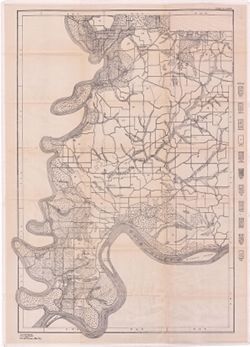
- Subject:
- Geographic Subject: Spencer County (Ind.), Geographic Subject: Daviess County (Ky.), and Geographic Subject: Warrick County (Ind.)
- Creator:
- Geological Survey (U.S.), Cooke, Chas. E. (Charles E.), Renshawe, John H., and Hawkins, Geo. T. (George T.)
- Publisher:
- Geological Survey (U.S.)
- Date Created:
- 1912
- Identifier:
- VAC3073-M-01373
- Genre:
- 15 minute topographic maps, Topographic maps, and Quadrangle maps
- Geographic Location:
- Coordinates: W0871500 W0870000 N0380000 N0374500
- Related URL:
- Catalog URL: https://iucat.iu.edu/catalog/18413576
- Abstract:
- John H. Renshaw, geographer in charge , control by George T. Hawkins , topography by Chas. E. Cooke. Filing title: Owensboro, Ind.-Ky. Edition of Nov. 1901. ...
- Call Number:
- G4090 s62 .G4 Owensboro 1901 rep 1912
- Caption:
- Imprint: Washington, D.C. : The Survey, 1912.
- Physical Description:
- Scale: 1:62,500 and Dimensions: 45 x 42 cm or smaller
- Alternate Identifier:
- Title Control Number: a18413576
- Persistent URL:
- https://purl.dlib.indiana.edu/iudl/images/VAC3073/VAC3073-M-01373
- Provenance:
- Part of Geological Survey (U.S.). Indiana 1:62,500.
-
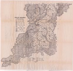
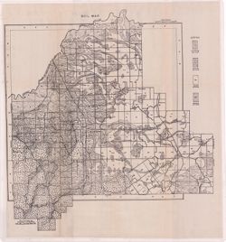
- Subject:
- Topical Subject: Mines and mineral resources, Topical Subject: Soils, Geographic Subject: Knox County (Ind.), and Topical Subject: Geology
- Creator:
- Shannon, M. E. and Shannon, C. W. (Charles William), 1879-1934
- Publisher:
- Indiana. Department of Geology and Natural Resources
- Date Created:
- 1912
- Identifier:
- VAC3073-M-01089
- Genre:
- Thematic maps
- Geographic Location:
- Coordinates: W0874524 W0870526 N0385428 N0382451
- Related URL:
- Catalog URL: https://iucat.iu.edu/catalog/16929613
- Abstract:
- Shows soil types, dirt roads, improved roads, railroads, schools, cemeteries, and churches. Detached from: Soil survey of Clay, Knox, Sullivan, and Vigo c...
- Call Number:
- G4093.K5J3 1911 .S5
- Caption:
- Imprint: [Indianapolis] : [Wm. B. Burford], [1912] and Imprint: [Indianapolis] : [Department of Geology and Natural Resources], [1912]
- Physical Description:
- Dimensions: 67 x 70 cm and Scale: Approximately 1:86,000
- Alternate Identifier:
- Title Control Number: a16929613 and Alternate ID: 390726IP
- Persistent URL:
- https://purl.dlib.indiana.edu/iudl/images/VAC3073/VAC3073-M-01089
- Provenance:
- 36th Annual Report (1911) / Indiana. Department of Geology and Natural Resources.
-
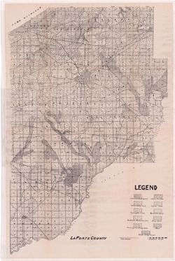
- Subject:
- Topical Subject: IGS Annual Reports, Topical Subject: Soils, Geographic Subject: LaPorte County (Ind.), and Topical Subject: Soil surveys
- Publisher:
- Indiana. Department of Geology and Natural Resources
- Date Created:
- 1912
- Identifier:
- VAC3073-M-01082
- Genre:
- Thematic maps
- Geographic Location:
- Coordinates: W0865600 W0862910 N0414539 N0411412
- Related URL:
- Catalog URL: https://iucat.iu.edu/catalog/16131280
- Abstract:
- Variant title: La Porte County. Shows soil types, dirt roads, improved roads, and railroads. Detached from: Soil survey of Laporte County / E.J. Quinn. In...
- Call Number:
- G4093.L15J3 1911 .L37
- Caption:
- Imprint: [Indianapolis] : [Wm. B. Burford], [1912] and Imprint: [Indianapolis] : [Department of Geology and Natural Resources, Indiana], [1912]
- Physical Description:
- Dimensions: on sheet 70 x 46 cm
- Alternate Identifier:
- Title Control Number: a16131280 and Alternate ID: 390726IP
- Persistent URL:
- https://purl.dlib.indiana.edu/iudl/images/VAC3073/VAC3073-M-01082
- Provenance:
- 36th Annual Report (1911) / Indiana. Geological Survey.
-
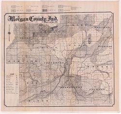
- Subject:
- Topical Subject: Soils and Geographic Subject: Morgan County (Ind.)
- Creator:
- Edmonson, James Bartlett, 1882-1954
- Publisher:
- Indiana. Department of Geology and Natural Resources
- Date Created:
- 1912
- Identifier:
- VAC3073-M-01094
- Genre:
- Thematic maps
- Geographic Location:
- Coordinates: W0864115 W0861459 N0393801 N0392017
- Related URL:
- Catalog URL: https://iucat.iu.edu/catalog/16096234
- Abstract:
- Shows soil types, school houses, cemeteries, churches, railroads, county roads and township roads. Detached from: Soil survey of Morgan County / J.B. Edmo...
- Call Number:
- G4093.M9J3 1911 .E3
- Caption:
- Imprint: [Indianapolis] : [Department of Geology and Natural Resources, Indiana], [1912] [Indianapolis] : [Wm. B. Burford], [1912]
- Physical Description:
- Scale: Approximately 1:63,360 and Dimensions: 52 x 61 cm
- Alternate Identifier:
- Alternate ID: 390726IP and Title Control Number: a16096234
- Persistent URL:
- https://purl.dlib.indiana.edu/iudl/images/VAC3073/VAC3073-M-01094
- Provenance:
- 36th Annual Report (1911) / Indiana. Department of Geology and Natural Resources.
-
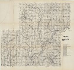
- Subject:
- Topical Subject: Soils and Geographic Subject: Owen County (Ind.)
- Creator:
- Indiana. Department of Geology and Natural Resources
- Publisher:
- Indiana. Department of Geology and Natural Resources
- Date Created:
- 1912
- Identifier:
- VAC3073-M-01070
- Genre:
- Thematic maps
- Geographic Location:
- Coordinates: W0870317 W0863750 N0392824 N0390956
- Related URL:
- Catalog URL: https://iucat.iu.edu/catalog/16096159
- Abstract:
- Shows soil types. Also shows roads and railroads. Detached from: Soil survey of Owen County / J.B. Edmondson. In Thirty-sixth annual report of Department ...
- Call Number:
- G4093.O8J3 1911 .I53
- Caption:
- Imprint: [Indianapolis] : [Wm. B. Burford], [1912] and Imprint: [Indianapolis] : [Department of Geology and Natural Resources, Indiana], [1912]
- Physical Description:
- Scale: Approximately 1:63,360 and Dimensions: 59 x 65 cm
- Alternate Identifier:
- Title Control Number: a16096159 and Alternate ID: 390726IP
- Persistent URL:
- https://purl.dlib.indiana.edu/iudl/images/VAC3073/VAC3073-M-01070
- Provenance:
- 36th Annual Report (1911) / Indiana. Department of Geology and Natural Resources.
-
- Subject:
- Topical Subject: Soils and Geographic Subject: Posey County (Ind.)
- Creator:
- Marean, Herbert W.
- Publisher:
- Indiana. Department of Geology and Natural Resources
- Date Created:
- 1912
- Identifier:
- VAC3073-M-01091
- Genre:
- Thematic maps
- Geographic Location:
- Coordinates: W0880557 W0874117 N0381349 N0374618
- Related URL:
- Catalog URL: https://iucat.iu.edu/catalog/16135740
- Abstract:
- Soils surveyed by Herbert W. Marean, 1902, U.S. Bureau of Soils. Detached from: Soil survey of Posey County, Indiana / Herbert W. Marean. In Thirty-sixth ...
- Call Number:
- G4093.P6J3 1902 .M3
- Caption:
- Imprint: [Indianapolis] : [Department of Geology and Natural Resources], [1912] and Imprint: [Indianapolis] : [Wm. B. Burford], [1912]
- Physical Description:
- Dimensions: 79 x 55 cm and Scale: Approximately 1:66,000
- Alternate Identifier:
- Alternate ID: 390726IP and Title Control Number: a16135740
- Persistent URL:
- https://purl.dlib.indiana.edu/iudl/images/VAC3073/VAC3073-M-01091
- Provenance:
- 36th Annual Report (1911) / Indiana. Department of Geology and Natural Resources.

- « Previous
- Next »
- 1
- 2
- 3