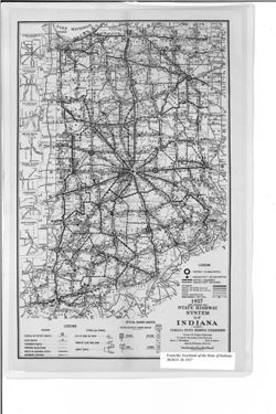
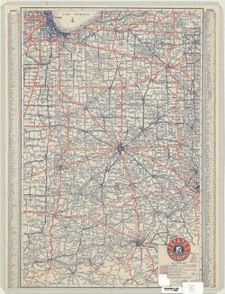
Shows roads by surface and composition type as well as official highway markers, boundaries and headquarters for districts and sub-districts, and constructio...
Call Number:
G4091.P2 1927 .I5
Caption:
Imprint: [Indianapolis] : [Wm. B. Burford, contractor for state printing and binding], [1928] and Imprint: [Indianapolis] : [The Legislative Bureau], [1928]
Physical Description:
Scale: Approximately 1:1,370,000 and Dimensions: 36 x 23 cm, on sheet 41 x 26 cm
Alternate Identifier:
Alternate ID: 397754IP and Title Control Number: a18455609
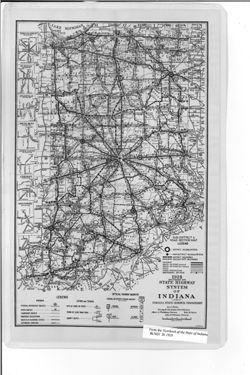
Caption title: Sub-district & road section map. Shows roads by surface and composition type as well as official highway markers, boundaries and headquart...
Call Number:
G4091.P2 1928 .I5
Caption:
Imprint: [Indianapolis] : [Wm. B. Burford, contractor for state printing and binding], [1929] and Imprint: [Indianapolis] : [The Legislative Bureau], [1929]
Physical Description:
Scale: Approximately 1:1,370,000 and Dimensions: 36 x 23 cm, on sheet 41 x 26 cm
Alternate Identifier:
Title Control Number: a18455614 and Alternate ID: 397754IP
Geographic Subject: Indiana and Topical Subject: Roads
Creator:
George F. Cram Company
Publisher:
George F. Cram Company
Date Created:
1929
Identifier:
VAC3073-M-00794
Genre:
Road maps
Geographic Location:
Coordinates: W0880700 W0844500 N0414500 N0375200
Related URL:
Catalog URL: https://iucat.iu.edu/catalog/5051245
Abstract:
Issued by the State Automobile Insurance Association. Includes place name index on recto. Advertisements and "Section of transcontinental highway map&...
Caption title: Sub-district & road section map. Shows roads by surface and composition type as well as official highway markers, boundaries and headquart...
Call Number:
G4091.P2 1929 .I5
Caption:
Imprint: [Indianapolis] : [Wm. B. Burford, contractor for state printing and binding], [1930] and Imprint: [Indianapolis] : [The Legislative Bureau], [1930]
Physical Description:
Scale: Approximately 1:1,370,000 and Dimensions: 38 x 23 cm, on sheet 43 x 26 cm
Alternate Identifier:
Alternate ID: 397754IP and Title Control Number: a18455618
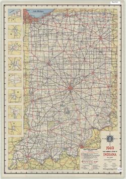
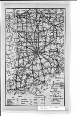
Panel title: 1949 Indiana official highway map. Relief shown by spot heights. Includes 8 local route maps. Index, distance chart, distance map of the United ...
Call Number:
G1403 .S7 1949
Caption:
Imprint: [Indianapolis] : State Highway Commission, [1949]
Physical Description:
Dimensions: 94 x 59 cm and Scale: Approximately 1:633,600


![1936-37 map and business directory of Angola [cartographic material] / presented by The News cooperating with C.W. Chadwick ... and Angola's many business firms](https://iiif.uits.iu.edu/iiif/2/bv73d330m%2Ffiles%2F6e02a868-a625-4ffb-813d-a29eee846987/full/250,/0/default.jpg)