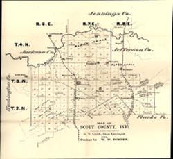
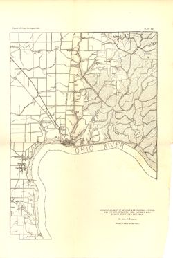
Prepared for the sixth annual report of E.T. Cox, State Geologist / geology by W.W. Borden, 1874. Relief shown by hachures. Shows cities and towns, railroads...
Call Number:
G4093.S3G46 1874 .B6
Caption:
Imprint: [Indianapolis] : [Geological Survey of Indiana], [1875] and Imprint: [Indianapolis, Indiana] : [Sentinel Co., printers], [1875]
Physical Description:
Scale: Approximately 1:130,000 and Dimensions: 31 x 30 cm, on sheet 38 x 35 cm
Alternate Identifier:
Alternate ID: 390723IP and Title Control Number: a18318693
Geographic Subject: Vanderburgh County (Ind.), Topical Subject: Coal mines and mining, Topical Subject: Mines and mineral resources, Topical Subject: Geology...
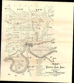
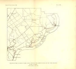
Compiled for the 7th annual report of E.T. Cox, State Geologist , geology by Prof. John Collett, 1875. Relief shown by hachures. Shows cities and towns, rail...
Call Number:
G4093.V3C5 1875 .C6
Caption:
Imprint: [Indianapolis] : [Geological Survey of Indiana], [1876] and Imprint: [Indianapolis] : [Sentinel Company, printers], [1876]
Physical Description:
Scale: Approximately 1:130,000 and Dimensions: on sheet 41 x 31 cm
Alternate Identifier:
Alternate ID: 390723IP and Title Control Number: a18349316
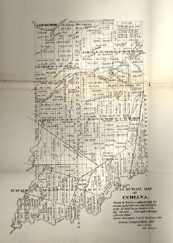
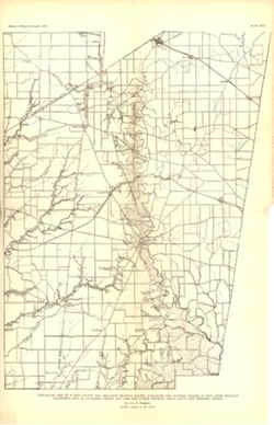
Showing the Districts as subdivided by the U.S. Surveys, together with each name and date of survey. The dotted lines are boundaries of Districts. Ebenezer ...
Call Number:
G4091.G46 1882 .C655
Caption:
Imprint: [Indianapolis] :, b[Indiana Dept. of Geology and Natural History],, and c[1882]
Physical Description:
Scale: Scale not given. and Dimensions: 35 x 27 cm
Alternate Identifier:
Alternate ID: 390725IP and Title Control Number: a18174045
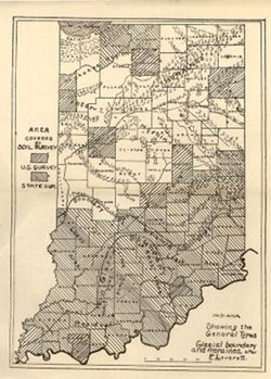
Shows counties covered by a U.S. soil survey or a state soil survey. Detached from: Glaciation and soils / Edward Barrett. In Thirty-sixth annual report o...
Call Number:
G4091.C38 1911 .I5
Caption:
Imprint: [Indianapolis] : [Department of Geology and Natural Resources, Indiana], [1912]
Physical Description:
Scale: Approximately 1:1,750,000 and Dimensions: 24 x 18 cm
Alternate Identifier:
Alternate ID: 390726IP and Title Control Number: a18307837
Geographic Subject: Jefferson County (Ind.), Topical Subject: IGS Annual Reports, Topical Subject: Geology, Stratigraphic--Silurian, and Topical Subject: Geo...
Creator:
Foerste, Aug. F. (Aug. Frederic), 1862-1936
Publisher:
Indiana. Department of Geology and Natural Resources
Date Created:
1897
Identifier:
VAC3073-M-01143
Genre:
Geological maps
Geographic Location:
Coordinates: W0853007 W0851205 N0385714 N0383358
Related URL:
Catalog URL: new.iucat.iu.edu/catalog/4022271
Abstract:
"Plate XV." Detached from: A report on the geology of the middle and upper Silurian rocks of Clark, Jefferson, Ripley, Jennings and southern Decatu...
Call Number:
G4093.J5C57 1896 .F6
Caption:
Imprint: [Indianapolis] : [Indiana Dept. of Geology and Natural Resources], [1897]
Physical Description:
Dimensions: 36 x 25 cm and Scale: Approximately 1:126,720. 2 miles to the in.
"Plate XIV." Detached from: A report on the geology of the middle and upper Silurian rocks of Clark, Jefferson, Ripley, Jennings and southern Decat...
Call Number:
G4093.C4C57 1896 .F6
Caption:
Imprint: [Indianapolis] : [Indiana Dept. of Geology and Natural Resources], [1897]
Physical Description:
Dimensions: 23 x 24 cm and Scale: Approximately 1:126,720. 2 miles = 1 inch
Alternate Identifier:
Title Control Number: a17036420 and Alternate ID: 390726IP
"Plate XVI." Detached from: A report on the geology of the middle and upper Silurian rocks of Clark, Jefferson, Ripley, Jennings and southern Decat...
Call Number:
G4093.R5C57 1896 .F6
Caption:
Imprint: [Indianapolis] : [Indiana Dept. of Geology and Natural Resources], [1897]
Physical Description:
Scale: Approximately 1:126,720. 2 miles = 1 inch and Dimensions: 41 x 27 cm
Alternate Identifier:
Alternate ID: 390726IP and Title Control Number: a17036513
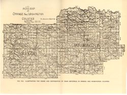
Geographic Subject: Washington County (Ind.), Topical Subject: Quarries and quarrying, Geographic Subject: Orange County (Ind.), Topical Subject: Road materi...
Publisher:
Indiana. Department of Geology and Natural Resources
Alternate title: Illustrating the roads and distribution of road materials in Orange and Washington counties. At head of title: Fig. 53A. Shows macadam quarr...
Call Number:
G4093.O6P2 1905 .R6
Caption:
Imprint: [Indianapolis] : [Indiana Dept. of Geology and Natural Resources], [1906]
Physical Description:
Dimensions: 16 x26 cm and Scale: Approximately 1:288,000
Alternate Identifier:
Alternate ID: 390726IP and Title Control Number: a18299120
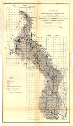
To accompany the report on the Bedford Oolitic Limestone by T.C. Hopkins and C.E. Siebenthal. Shows abandoned quarries. Detached from: The Bedford oö...
Call Number:
G4094.B5C5 1896 .G4
Caption:
Imprint: [Indianapolis] : [Department of Geology and Natural Resources of Indiana], [1897] and Imprint: Indianapolis : Wm. Burford, [1897]
Physical Description:
Dimensions: 57 x 28 cm and Scale: Approximately 1:126,720. 2 miles = 1 inch
Alternate Identifier:
Alternate ID: 390726IP and Title Control Number: a18416402
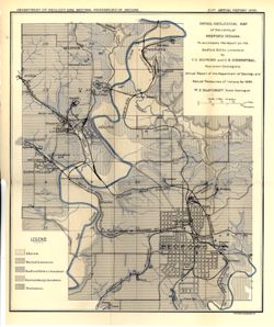
To accompany the report on the Bedford oölitic limestone, T.C. Hopkins and C.E. Siebenthal, assistant geologists : annual report of the Department of Ge...
Call Number:
G4094.B3C5 1896 .D4
Caption:
Imprint: [Indianapolis] : Dept. of Geology and Natural Resources of Indiana, [1897] and Imprint: Indianapolis, Ind. : Wm. B. Burford, Lith, [1897]
Physical Description:
Scale: Approximatley 1:31,680. 1 mile = 2 in. and Dimensions: 33 x 28 cm
Alternate Identifier:
Title Control Number: a17036030 and Alternate ID: 390726IP