
Search Constraints
You searched for:
Date Created
1905
Remove constraint Date Created: 1905
Collections
Indiana Historic Maps
Remove constraint Collections: Indiana Historic Maps
« Previous |
1 - 10 of 13
|
Next »
Search Results
-
- Subject:
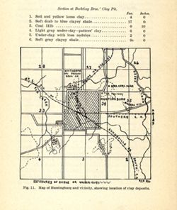
- Geographic Subject: Huntingburg Region (Ind.), Topical Subject: Clay, Topical Subject: IGS Annual Reports, Geographic Subject: Dubois County (Ind.), and Topi...
- Creator:
- Blatchley, Raymond S. (Raymond Sillliman)
- Publisher:
- Indiana. Department of Geology and Natural Resources
- Date Created:
- 1905
- Identifier:
- VAC3073-M-01587
- Genre:
- Geological maps
- Geographic Location:
- Coordinates: W0865919 W0865616 N0381927 N0381621
- Related URL:
- Catalog URL: https://iucat.iu.edu/catalog/18282191
- Abstract:
- Shows locations of clay deposits and local brick and tile companies. Also includes listings of measurements for the Bockting Bros.' clay pit. "Fig....
- Call Number:
- G4094.H8H5 1904 .M37
- Caption:
- Imprint: [Indianapolis] : [Wm. B. Burford], [1905] and Imprint: [Indianapolis] : [Indiana Department of Geology and Natural Resources], [1905]
- Physical Description:
- Scale: Approximately 1:46,650 and Dimensions: on sheet 17 x 14 cm
- Alternate Identifier:
- Alternate ID: 390726IP and Title Control Number: a18282191
- Persistent URL:
- https://purl.dlib.indiana.edu/iudl/images/VAC3073/VAC3073-M-01587
- Provenance:
- 29th Annual Report (1904) / Indiana. Department of Geology and Natural Resources.
-
- Subject:
- Geographic Subject: Brazil (Ind.), Topical Subject: IGS Annual Reports, Topical Subject: Clay industries, and Topical Subject: Clay
- Creator:
- Blatchley, Raymond S. (Raymond Sillliman)
- Publisher:
- Indiana. Department of Geology and Natural Resources
- Date Created:
- 1905
- Identifier:
- VAC3073-M-01586
- Genre:
- Geological maps
- Geographic Location:
- Coordinates: W0870852 W0870554 N0393212 N0393014
- Related URL:
- Catalog URL: https://iucat.iu.edu/catalog/18279473
- Abstract:
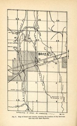
- Title from caption. "Fig. 8." "RSB DEL." Shows locations of clay deposits as well as mining, clay works, brick, and sewer pipe companies....
- Call Number:
- G4093.P2H5 1904 .B75
- Caption:
- Imprint: [Indianapolis] : [Wm. B. Burford], [1905] and Imprint: [Indianapolis] : [Indiana Department of Geology and Natural Resources], [1905]
- Physical Description:
- Scale: Approximately 1:46,650 and Dimensions: on sheet 22 x 14 cm
- Alternate Identifier:
- Title Control Number: a18279473 and Alternate ID: 390726IP
- Persistent URL:
- https://purl.dlib.indiana.edu/iudl/images/VAC3073/VAC3073-M-01586
- Provenance:
- 29th Annual Report (1904) / Indiana. Department of Geology and Natural Resources.
-
- Subject:
- Geographic Subject: Bridgeton Region (Ind.), Topical Subject: Mines and mineral resources, Geographic Subject: Parke County (Ind.), Topical Subject: IGS Annu...
- Publisher:
- Indiana. Department of Geology and Natural Resources
- Date Created:
- 1905
- Identifier:
- VAC3073-M-01585
- Genre:
- Geological maps
- Geographic Location:
- Coordinates: W0871115 W0870900 N0394130 N0393800
- Related URL:
- Catalog URL: https://iucat.iu.edu/catalog/18279221
- Abstract:
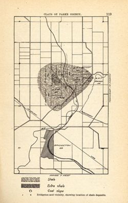
- Shows location of shale, extra shale, and coal slope. "Clays of Parke County." Detached from: The clays and clay industries of Indiana / W. S. B...
- Call Number:
- G4093.P2H5 1904 .B75
- Caption:
- Imprint: [Indianapolis] : [Indiana Department of Geology and Natural Resources], [1905] and Imprint: [Indianapolis] : [Wm. B. Burford], [1905]
- Physical Description:
- Scale: Scale not given. and Dimensions: on sheet 22 x 14 cm
- Alternate Identifier:
- Alternate ID: 390726IP and Title Control Number: a18279221
- Persistent URL:
- https://purl.dlib.indiana.edu/iudl/images/VAC3073/VAC3073-M-01585
- Provenance:
- 29th Annual Report (1904) / Indiana. Department of Geology and Natural Resources.
-
- Subject:
- Geographic Subject: Mecca Region (Ind.), Topical Subject: Clay, Topical Subject: Clay industries, Topical Subject: Shale, Geographic Subject: Parke County (I...
- Creator:
- Blatchley, Raymond S. (Raymond Sillliman)
- Publisher:
- Indiana. Department of Geology and Natural Resources
- Date Created:
- 1905
- Identifier:
- VAC3073-M-01584
- Genre:
- Geological maps
- Geographic Location:
- Coordinates: W0872106 W0871741 N0394423 N0394217
- Related URL:
- Catalog URL: https://iucat.iu.edu/catalog/18282202
- Abstract:
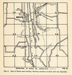
- Title from caption. Shows locations of shale and clay deposits, clay mines, and local brick and clay works companies. Also includes listing of measurements f...
- Call Number:
- G4093.P2H5 1904 .M37
- Caption:
- Imprint: [Indianapolis] : [Indiana Department of Geology and Natural Resources ], [1905] and Imprint: [Indianapolis] : [Wm. B. Burford], [1905]
- Physical Description:
- Dimensions: on sheet 12 x 12 cm and Scale: Approximately 1:46,650
- Alternate Identifier:
- Alternate ID: 390726IP and Title Control Number: a18282202
- Persistent URL:
- https://purl.dlib.indiana.edu/iudl/images/VAC3073/VAC3073-M-01584
- Provenance:
- 29th Annual Report (1904) / Indiana. Department of Geology and Natural Resources.
-
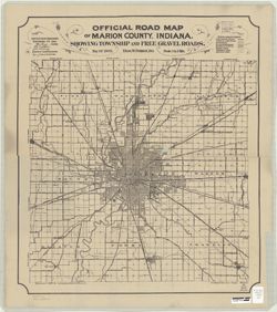
- Subject:
- Geographic Subject: Indianapolis (Ind.), Topical Subject: Roads, and Geographic Subject: Marion County (Ind.)
- Creator:
- Palmer, Thos. W. (Thomas W.)
- Publisher:
- Indianapolis Map & Platting Co.
- Date Created:
- 1905
- Identifier:
- VAC3073-M-00652
- Genre:
- Road maps
- Geographic Location:
- Coordinates: W0861941 W0855614 N0395538 N0393755
- Related URL:
- Catalog URL: https://iucat.iu.edu/catalog/6082201
- Abstract:
- "H.C. Bauer Eng. Co." Copy 1 has red annotations.
- Call Number:
- G4093.M3 P2 1905 .P3
- Caption:
- Imprint: Indianapolis, Ind. : Indianapolis Map & Platting Co., [1905]
- Physical Description:
- Scale: 1:64,000 and Dimensions: 63 x 55 cm, on sheet 69 x 61 cm
- Alternate Identifier:
- Title Control Number: a6082201
- Persistent URL:
- https://purl.dlib.indiana.edu/iudl/images/VAC3073/VAC3073-M-00652
-
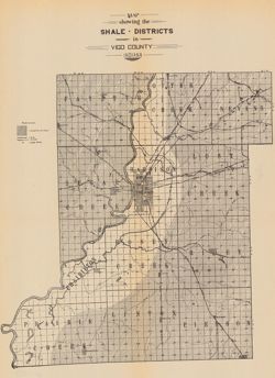
- Subject:
- Topical Subject: Mines and mineral resources, Topical Subject: IGS Annual Reports, Topical Subject: Shale, and Geographic Subject: Vigo County (Ind.)
- Publisher:
- Indiana. Department of Geology and Natural Resources
- Date Created:
- 1905
- Identifier:
- VAC3073-M-00397
- Genre:
- Geological maps
- Geographic Location:
- Coordinates: W0873635 W0871156 N0393634 N0391532
- Related URL:
- Catalog URL: https://iucat.iu.edu/catalog/18282217
- Abstract:
- Shows shale deposits, coal mines, and railroads. Detached from: The clays and clay industries of Indiana / W.S. Blatchley. In Indiana Dept. of Geology and...
- Call Number:
- G4093.V5C5 1904 .M37
- Caption:
- Imprint: [Indianapolis] : [Wm. B. Burford], [1905] and Imprint: [Indianapolis] : [Indiana Department of Geology and Natural Resources], [1905]
- Physical Description:
- Scale: Approximately 1:150,000 and Dimensions: on sheet 36 x 27 cm
- Alternate Identifier:
- Alternate ID: 390726IP and Title Control Number: a18282217
- Persistent URL:
- https://purl.dlib.indiana.edu/iudl/images/VAC3073/VAC3073-M-00397
- Provenance:
- 29th Annual Report (1904) / Indiana. Department of Geology and Natural Resources.
-
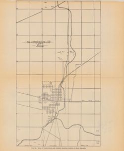
- Subject:
- Geographic Subject: Veedersburg City Region (Ind.), Topical Subject: Shale, Geographic Subject: Fountain County (Ind.), and Topical Subject: IGS Annual Reports
- Publisher:
- Indiana. Department of Geology and Natural Resources
- Date Created:
- 1905
- Identifier:
- VAC3073-M-00371
- Genre:
- Geological maps
- Geographic Location:
- Coordinates: W0871723 W0871347 N0401012 N0400505
- Related URL:
- Catalog URL: https://iucat.iu.edu/catalog/18282209
- Abstract:
- Caption title: Map of Veedersburg and vicinity, showing the location of shale deposits. "Fig. 2a." Detached from: The clays and clay industries ...
- Call Number:
- G4094.V3H5 1904 .M37
- Caption:
- Imprint: [Indianapolis] : [Wm. B. Burford], [1905] and Imprint: [Indianapolis] : [Indiana Department of Geology and Natural Resources], [1905]
- Physical Description:
- Dimensions: on sheet 27 x 23 cm and Scale: Approximately 1:34,250
- Alternate Identifier:
- Alternate ID: 390726IP and Title Control Number: a18282209
- Persistent URL:
- https://purl.dlib.indiana.edu/iudl/images/VAC3073/VAC3073-M-00371
- Provenance:
- 29th Annual Report (1904) / Indiana. Department of Geology and Natural Resources.
-
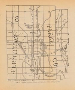
- Subject:
- Geographic Subject: Montezuma (Ind.), Topical Subject: Shale, Topical Subject: Clay industries, Geographic Subject: Vermillion County (Ind.), Topical Subject...
- Creator:
- Blatchley, Raymond S. (Raymond Sillliman)
- Publisher:
- Indiana. Department of Geology and Natural Resources
- Date Created:
- 1905
- Identifier:
- VAC3073-M-00274
- Genre:
- Geological maps
- Geographic Location:
- Coordinates: W0872510 W0872023 N0395020 N0394532
- Related URL:
- Catalog URL: https://iucat.iu.edu/catalog/18282337
- Abstract:
- Shows the location of clay and shale deposits as well as the locations of brick, clay works, and tile companies. At head of title: Fig. 5. "R.S.B. Del.&...
- Call Number:
- G4094.M68H5 1904 .V53
- Caption:
- Imprint: [Indianapolis] : [Wm. B. Burford], [1905] and Imprint: [Indianapolis] : [Indiana Department of Geology and Natural Resources], [1905]
- Physical Description:
- Dimensions: 23 x 19 cm and Scale: Approximately 1:53,000
- Alternate Identifier:
- Alternate ID: 390726IP and Title Control Number: a18282337
- Persistent URL:
- https://purl.dlib.indiana.edu/iudl/images/VAC3073/VAC3073-M-00274
- Provenance:
- 29th Annual Report (1904) / Indiana. Department of Geology and Natural Resources.
-
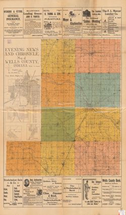
- Subject:
- Geographic Subject: Vera Cruz (Ind.), Topical Subject: Real property, Geographic Subject: Bluffton (Ind.), Geographic Subject: Keystone (Ind.), Geographic Su...
- Creator:
- Kibele, Cuno
- Publisher:
- Kibele, Cuno
- Date Created:
- 1905
- Identifier:
- VAC3073-M-00202
- Genre:
- Cadastral maps
- Geographic Location:
- Coordinates: W0852700 W0850400 N0405500 N0403400
- Related URL:
- Catalog URL: https://iucat.iu.edu/catalog/2797505
- Abstract:
- Cadastral map showing landowners. Includes "Explanation of rural free delivery", advertisements and ancillary maps of Bluffton, West Ossian and ...
- Call Number:
- G4093 .W7G46 1905 .K53
- Caption:
- Imprint: Bluffton, Ind.: Cuno Kibele, 1905.
- Physical Description:
- Scale: 1:42,000 and Dimensions: 93 x 79 cm, on sheet 145 x 86 cm
- Alternate Identifier:
- Title Control Number: CAG7315BB
- Persistent URL:
- https://purl.dlib.indiana.edu/iudl/images/VAC3073/VAC3073-M-00202
-
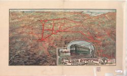
- Subject:
- Topical Subject: Electric railroads, Geographic Subject: Ohio, and Geographic Subject: Indiana
- Creator:
- Bloomer, William L. (William Lowe)
- Publisher:
- Bloomer, William L. (William Lowe)
- Date Created:
- 1905
- Identifier:
- VAC3073-M-00143
- Genre:
- Thematic maps
- Geographic Location:
- Coordinates: W0880500 W0844700 N0414500 N0374600
- Related URL:
- Catalog URL: https://iucat.iu.edu/catalog/5054958
- Abstract:
- Perspective map. Author and publication information from LC copyright record. "Indiana Union Traction Co., General Offices, Anderson, Ind."
- Call Number:
- G4091 .P33 1905 .B556
- Caption:
- Imprint: [Galion, Ohio? : Wm. L. Bloomer?, c1905]
- Physical Description:
- Scale: Not drawn to scale. and Dimensions: 37 x 69 cm
- Alternate Identifier:
- Title Control Number: a5054958
- Persistent URL:
- https://purl.dlib.indiana.edu/iudl/images/VAC3073/VAC3073-M-00143
