
Search Constraints
You searched for:
Publisher
Indiana. Geological Survey
Remove constraint Publisher: Indiana. Geological Survey
Subject
Topical Subject: Geology
Remove constraint Subject: Topical Subject: Geology
1 - 29 of 29
Search Results
-
- Subject:
- Geographic Subject: Indiana and Topical Subject: Geology
- Creator:
- Patton, John B. (John Barratt), 1915-
- Publisher:
- Indiana. Geological Survey
- Date Created:
- 1951
- Identifier:
- VAC3073-M-00349
- Genre:
- Geological maps
- Geographic Location:
- Coordinates: W0873622 W0844704 N0400224 N0374618
- Related URL:
- Catalog URL: https://iucat.iu.edu/catalog/6232196
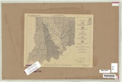
- Abstract:
- Blue line. "Not for publication for correspondence use only"-- Upper margin.
- Call Number:
- G4091.C5 1951 .P38
- Caption:
- Imprint: [Bloomington, Ind.] : Indiana Dept. of Conservation, Geological Survey, 1951.
- Physical Description:
- Dimensions: 20 x 26 cm and Scale: Approximately 1:1,500,000
- Alternate Identifier:
- Title Control Number: a6232196
- Persistent URL:
- https://purl.dlib.indiana.edu/iudl/images/VAC3073/VAC3073-M-00349
-
- Subject:
- Topical Subject: Geology and Geographic Subject: Indiana
- Creator:
- Patton, John B. (John Barratt), 1915-
- Publisher:
- Indiana. Geological Survey
- Date Created:
- 1956
- Identifier:
- VAC3073-M-00212
- Genre:
- Geological maps
- Geographic Location:
- Coordinates: W0880000 W0844500 N0414500 N0375200
- Related URL:
- Catalog URL: https://iucat.iu.edu/catalog/5888483
- Abstract:
- "Base from Map of Indiana, 1950 edition, published by the U.S. Geological Survey. Minor revisions and additions made from Indiana Department of Conserva...
- Call Number:
- G4091 .C5 1956 .P3
- Caption:
- Imprint: [Bloomington] : Indiana Geological Survey, 1956.
- Physical Description:
- Dimensions: 59 x 31 cm and Scale: 1:1,000,000
- Alternate Identifier:
- Title Control Number: a5888483
- Persistent URL:
- https://purl.dlib.indiana.edu/iudl/images/VAC3073/VAC3073-M-00212
-
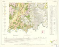
- Subject:
- Geographic Subject: Indiana, Topical Subject: Geology, Stratigraphic, Geographic Subject: Ohio, and Topical Subject: Geology
- Creator:
- Schneider, Allan F. (Allan Frank), 1926-, Gooding, Ansel Miller, Forsyth, Jane L. (Jane Louise), 1921-, Gray, Henry Hamilton, 1922-, and Indiana. Geological ...
- Publisher:
- Indiana. Geological Survey
- Date Created:
- 1972
- Identifier:
- VAC3073-M-01245
- Genre:
- Geological maps, Geological cross-sections, and Quadrangle maps
- Geographic Location:
- Coordinates: W0860000 W0840000 N0400000 N0390000
- Related URL:
- Catalog URL: https://iucat.iu.edu/catalog/16799790
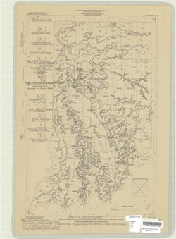
- Abstract:
- By Henry H. Gray, Jane L. Forsyth, Allan F. Schneider, and Ansel M. Gooding. Transverse Mercator projection. "Base map modified from Army Map Service, M...
- Call Number:
- G4091 .C5 1972 .G455
- Caption:
- Imprint: [Bloomington, Ind.] : Indiana Geological Survey, 1972
- Physical Description:
- Dimensions: 73 x 66 cm and Scale: 1:250,000
- Alternate Identifier:
- Title Control Number: a16799790
- Persistent URL:
- https://purl.dlib.indiana.edu/iudl/images/VAC3073/VAC3073-M-01245
- Provenance:
- Indiana. Geological Survey. Regional geologic map , no. 7.
-
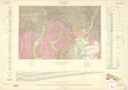
- Subject:
- Geographic Subject: Illinois, Topical Subject: Geology, Geographic Subject: Indiana, and Topical Subject: Geology, Stratigraphic
- Creator:
- Keller, Stanley J., Indiana. Geological Survey, Illinois State Geological Survey, Johnson, Gerald H., Wayne, William J. (William John), 1922-, and Atherton, ...
- Publisher:
- Indiana. Geological Survey
- Date Created:
- 1962
- Identifier:
- VAC3073-M-01248
- Genre:
- Geological maps, Quadrangle maps, and Geological cross-sections
- Geographic Location:
- Coordinates: W0880000 W0860000 N0410000 N0400000
- Related URL:
- Catalog URL: https://iucat.iu.edu/catalog/16799905
- Abstract:
- By William J. Wayne, Gerald H. Johnson, and Stanley J. Keller. Indiana Geological Survey in cooperation with Illinois State Geological Survey. Base modified ...
- Call Number:
- G4091.C5 s250 .I5 Danville 1962
- Caption:
- Imprint: [Indianapolis] : Indiana Geological Survey, 1966
- Physical Description:
- Scale: 1:250,000 and Dimensions: 76 x 105 cm
- Alternate Identifier:
- Title Control Number: a16799905
- Persistent URL:
- https://purl.dlib.indiana.edu/iudl/images/VAC3073/VAC3073-M-01248
- Provenance:
- Indiana. Geological Survey. Regional geologic map , no. 2.
-
- Subject:
- Topical Subject: Geology, Stratigraphic, Geographic Subject: Michigan, Geographic Subject: Ohio, Topical Subject: Geology, and Geographic Subject: Indiana
- Creator:
- Keller, Stanley J., Johnson, Gerald H., Michigan. Geological Survey, and Indiana. Geological Survey
- Publisher:
- Indiana. Geological Survey
- Date Created:
- 1972
- Identifier:
- VAC3073-M-01249
- Genre:
- Geological maps, Geological cross-sections, and Quadrangle maps
- Geographic Location:
- Coordinates: W0860000 W0840000 N0420000 N0410000
- Related URL:
- Catalog URL: https://iucat.iu.edu/catalog/18455585
- Abstract:
- By Gerald H. Johnson and Stanley J. Keller. transverse Mercator projection. Regional geologic map , no. 8. Relief shown by profile. Includes columnar section...
- Call Number:
- G4091.C5 s250 .I5 Fort Wayne 1972
- Caption:
- Imprint: [Bloomington] : Indiana Geological Survey, 1972
- Physical Description:
- Scale: 1:250,000. Vertical scale approximately 1:1,200 and Dimensions: 66 x 101 cm
- Alternate Identifier:
- Title Control Number: a18455585
- Persistent URL:
- https://purl.dlib.indiana.edu/iudl/images/VAC3073/VAC3073-M-01249
- Provenance:
- Indiana. Geological Survey. Regional geologic map , no. 8.
-
- Subject:
- Geographic Subject: Indiana, Geographic Subject: Illinois, Topical Subject: Geology, Stratigraphic, and Topical Subject: Geology
- Creator:
- Indiana. Geological Survey, Bleuer, N. K. (Ned Kermit), 1943-, Lineback, Jerry A. (Jerry Alvin), Hill, John R,, Gray, Henry Hamilton, 1922-, and Illinois Sta...
- Publisher:
- Indiana. Geological Survey
- Date Created:
- 1979
- Identifier:
- VAC3073-M-01251
- Genre:
- Quadrangle maps, Geological maps, and Geological cross-sections
- Geographic Location:
- Coordinates: W0880000 W0860000 N0400000 N0390000
- Related URL:
- Catalog URL: https://iucat.iu.edu/catalog/18437113
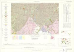
- Abstract:
- Indianapolis sheet. 1979 edition. Transverse Mercator projection. Geology compiled by H. H. Gray (Indiana) and J. A. Lineback (Illinois) from published and o...
- Call Number:
- G4091.C5 s250 .I5 Indianapolis 1979
- Caption:
- Imprint: [Bloomington] : Indiana Geological Survey, 1979
- Physical Description:
- Scale: 1:250,000. Vertical scale approximately 1:3,800 and Dimensions: 66 x 102 cm
- Alternate Identifier:
- Title Control Number: a18437113
- Persistent URL:
- https://purl.dlib.indiana.edu/iudl/images/VAC3073/VAC3073-M-01251
- Provenance:
- Indiana. Geological Survey. Regional geologic map , no. 1.
-
- Subject:
- Topical Subject: Geology, Geographic Subject: Indiana, and Topical Subject: Geology, Stratigraphic
- Creator:
- Gray, Henry Hamilton, 1922- and Indiana. Geological Survey
- Publisher:
- Indiana. Geological Survey
- Date Created:
- 1972
- Identifier:
- VAC3073-M-01255
- Genre:
- Geological cross-sections, Quadrangle maps, and Geological maps
- Geographic Location:
- Coordinates: W0860000 W0844500 N0390000 N0380000
- Related URL:
- Catalog URL: https://iucat.iu.edu/catalog/18454601
- Abstract:
- By Henry H. Gray. Compiled by H. H. Gray and A. M. Burger. Drafted by J. R. Tolen. Base map modified from Army Map Service Map NJ16-6, 1964. Transverse Merca...
- Call Number:
- G4091.C5 s250 .I5 Louisville 1972
- Caption:
- Imprint: [Bloomington, Indiana] : Indiana Geological Survey, 1972
- Physical Description:
- Scale: 1:250,000. Vertical scale approximately 1:11,500 and Dimensions: 66 x 102 cm
- Alternate Identifier:
- Title Control Number: a18454601
- Persistent URL:
- https://purl.dlib.indiana.edu/iudl/images/VAC3073/VAC3073-M-01255
- Provenance:
- Indiana. Geological Survey. Regional geologic map , no. 6.
-
- Subject:
- Geographic Subject: Indiana, Topical Subject: Geology, Topical Subject: Geology, Stratigraphic, and Geographic Subject: Ohio
- Creator:
- Indiana. Geological Survey, Burger, Ann M., Wayne, William J. (William John), 1922-, Forsyth, Jane L. (Jane Louise), 1921-, and Nicoll, Robert S.
- Publisher:
- Indiana. Geological Survey
- Date Created:
- 1971
- Identifier:
- VAC3073-M-01256
- Genre:
- Quadrangle maps, Geological maps, and Geological cross-sections
- Geographic Location:
- Coordinates: W0860000 W0840000 N0410000 N0400000
- Related URL:
- Catalog URL: https://iucat.iu.edu/catalog/18455599
- Abstract:
- By Ann M. Burger, Jane L. Forsyth, Robert S. Nicoll, and William J. Wayne , Indiana Geological Survey, Dept. of Natural Resources. Transverse Mercator projec...
- Call Number:
- G4091.C5 s250 .I5 Muncie 1971
- Caption:
- Imprint: [Bloomington, Ind.] : Indiana Geological Survey, 1971
- Physical Description:
- Dimensions: 105 x 73 cm and Scale: 1:250,000. Vertical scale approximately 1:11,500
- Alternate Identifier:
- Title Control Number: a18455599
- Persistent URL:
- https://purl.dlib.indiana.edu/iudl/images/VAC3073/VAC3073-M-01256
- Provenance:
- Indiana. Geological Survey. Regional geologic map , no. 5.
-

- Subject:
- Topical Subject: Geology, Stratigraphic, Topical Subject: Geology, Geographic Subject: Indiana, and Geographic Subject: Illinois
- Creator:
- Gray, Henry Hamilton, 1922-
- Publisher:
- Indiana. Geological Survey
- Date Created:
- 1910
- Identifier:
- VAC3073-M-01254
- Genre:
- Geological cross-sections, Quadrangle maps, and Geological maps
- Geographic Location:
- Coordinates: W0880000 W0860000 N0390000 N0380000
- Related URL:
- Catalog URL: https://iucat.iu.edu/catalog/18455600
- Abstract:
- By Henry H. Gray, William J. Wayne, and Charles E. Wier , Indiana Geological Survey, in cooperation with Illinois State Geological Survey. Transverse Mercato...
- Call Number:
- G4091.C5 s250 .I5 Vincennes
- Caption:
- Imprint: [Bloomington, Ind.] : The Survey, 1970
- Physical Description:
- Dimensions: 76 x 102 cm and Scale: 1:250,000. Vertical scale approximately 1:11,500
- Alternate Identifier:
- Title Control Number: a18455600
- Persistent URL:
- https://purl.dlib.indiana.edu/iudl/images/VAC3073/VAC3073-M-01254
- Provenance:
- Indiana. Geological Survey. Regional geologic map , no. 3.
-
- Subject:
- Geographic Subject: Illinois, Topical Subject: Geology, Topical Subject: Geology, Stratigraphic, and Geographic Subject: Indiana
- Creator:
- Gray, Henry Hamilton, 1922-, Wier, Charles E. (Charles Eugene), 1921-, Indiana. Geological Survey, Wayne, William J. (William John), 1922-, and Illinois Stat...
- Publisher:
- Indiana. Geological Survey
- Date Created:
- 1970
- Identifier:
- VAC3073-M-01257
- Genre:
- Quadrangle maps, Geological maps, and Geological cross-sections
- Geographic Location:
- Coordinates: W0880000 W0860000 N0390000 N0380000
- Related URL:
- Catalog URL: https://iucat.iu.edu/catalog/18455600
- Abstract:
- By Henry H. Gray, William J. Wayne, and Charles E. Wier , Indiana Geological Survey, in cooperation with Illinois State Geological Survey. Transverse Mercato...
- Call Number:
- G4091.C5 s250 .I5 Vincennes 1970
- Physical Description:
- Dimensions: 76 x 102 cm and Scale: 1:250,000
- Alternate Identifier:
- Title Control Number: a18455600
- Persistent URL:
- https://purl.dlib.indiana.edu/iudl/images/VAC3073/VAC3073-M-01257
- Provenance:
- Indiana. Geological Survey. Regional geologic map , no. 3.
-
- Subject:
- Topical Subject: Geology, Stratigraphic, Geographic Subject: Illinois, Topical Subject: Geology, and Geographic Subject: Indiana
- Creator:
- Wier, Charles E. (Charles Eugene), 1921-
- Publisher:
- Indiana. Geological Survey
- Date Created:
- 1961
- Identifier:
- VAC3073-M-01250
- Genre:
- Quadrangle maps, Geological maps, and Geological cross-sections
- Geographic Location:
- Coordinates: W0880000 W0860000 N0400000 N0390000
- Related URL:
- Catalog URL: https://iucat.iu.edu/catalog/18422608
- Abstract:
- By Charles E. Wier and Henry H. Gray. Geology by H.H. Gray [and others]. Drafted by R. E. Judah and W. H. Moran. Base modified from Army Map Service map NJ 1...
- Call Number:
- G4091.C5 s250 .I5 Indianapolis 1961
- Caption:
- Imprint: [Indianapolis] : Indiana Geological Survey, 1961
- Physical Description:
- Scale: 1:250,000. Vertical scale approximately 1:1,200 and Dimensions: on sheet 74 x 105 cm
- Alternate Identifier:
- Title Control Number: a18422608
- Persistent URL:
- https://purl.dlib.indiana.edu/iudl/images/VAC3073/VAC3073-M-01250
- Provenance:
- Indiana. Geological Survey. Regional geologic map.
-
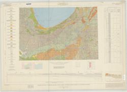
- Subject:
- Geographic Subject: Indiana, Northwest, Geographic Subject: Michigan, Geographic Subject: Indiana, Topical Subject: Geology, Geographic Subject: Illinois, To...
- Creator:
- Illinois State Geological Survey, Indiana. Geological Survey, Keller, Stanley J., and Schneider, Allan F. (Allan Frank), 1926-
- Publisher:
- Indiana. Geological Survey
- Date Created:
- 1970
- Identifier:
- VAC3073-M-01535
- Genre:
- Geological cross-sections, Quadrangle maps, and Geological maps
- Geographic Location:
- Coordinates: W0880000 W0860000 N0420000 N0410000
- Related URL:
- Catalog URL: https://iucat.iu.edu/catalog/17017966
- Abstract:
- By Allan F. Schneider and Stanley J. Keller. Transverse Mercator projection. "Indiana Geological Survey in cooperation with Illinois State Geological Su...
- Call Number:
- G4091.C5 1970 .G3
- Caption:
- Imprint: [Bloomington, Ind.] : Indiana Geological Survey, 1970
- Physical Description:
- Scale: 1:250,000 and Dimensions: 44 x 67 cm, on sheet 74 x 106 cm
- Alternate Identifier:
- Title Control Number: a17017966
- Persistent URL:
- https://purl.dlib.indiana.edu/iudl/images/VAC3073/VAC3073-M-01535
- Provenance:
- Indiana. Geological Survey. Regional geologic map , no. 4.
-
- Subject:
- Geographic Subject: Knox County (Ind.), Topical Subject: Geology, Topical Subject: Mines and mineral resources, Topical Subject: IGS Annual Reports, and Geog...
- Creator:
- Indiana. Geological Survey
- Publisher:
- Indiana. Geological Survey
- Date Created:
- 1874
- Identifier:
- VAC3073-M-01451
- Genre:
- Geological maps
- Related URL:
- Catalog URL: https://iucat.iu.edu/catalog/4022269
- Call Number:
- QE109 .A2 1874
- Caption:
- Imprint: Indianapolis : 1874.
- Persistent URL:
- https://purl.dlib.indiana.edu/iudl/images/VAC3073/VAC3073-M-01451
- Provenance:
- 5th Annual Report (1873) / Indiana. Geological Survey.
-
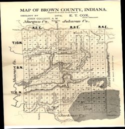
- Subject:
- Topical Subject: IGS Annual Reports, Geographic Subject: Brown County (Ind.), Topical Subject: Geology, and Topical Subject: Mines and mineral resources
- Creator:
- Collett, John, 1828-1899
- Publisher:
- Indiana. Geological Survey
- Date Created:
- 1875
- Identifier:
- VAC3073-M-01148
- Genre:
- Geological maps
- Geographic Location:
- Coordinates: W0862253 W0860449 N0392042 N0390248
- Related URL:
- Catalog URL: https://iucat.iu.edu/catalog/18318678
- Abstract:
- Prepared for the sixth annual report of E.T. Cox, State Geologist , geology by John Collett, 1874. Relief shown by hachures. Shows cities and towns, railroad...
- Call Number:
- G4093.B7C5 1874 .C6
- Caption:
- Imprint: [Indianapolis] : [Sentinel Company, printers], [1875] and Imprint: [Indianapolis] : [Geological Survey of Indiana], [1875]
- Physical Description:
- Scale: Approximately 1:120,000 and Dimensions: on sheet 39 x 35 cm
- Alternate Identifier:
- Alternate ID: 390723IP and Title Control Number: a18318678
- Persistent URL:
- https://purl.dlib.indiana.edu/iudl/images/VAC3073/VAC3073-M-01148
- Provenance:
- 6th Annual Report (1874) / Indiana. Geological Survey.
-
- Subject:
- Topical Subject: Geology, Geographic Subject: Clark County (Ind.), Topical Subject: Mines and mineral resources, Geographic Subject: Floyd County (Ind.), and...
- Creator:
- Cox, E. T. (Edward Travers), 1821-1907 and Borden, W. W. (William Wesley), 1823-1906
- Publisher:
- Indiana. Geological Survey
- Date Created:
- 1874
- Identifier:
- VAC3073-M-01155
- Genre:
- Geological maps
- Geographic Location:
- Coordinates: W0860258 W0852426 N0383636 N0380900
- Related URL:
- Catalog URL: https://iucat.iu.edu/catalog/18318611
- Abstract:
- Prepared for the 5th annual report of Prof. E.T. Cox, State Geologist, 1873 , geology by W.W. Borden. Relief shown by hachures. Shows cities and towns, railr...
- Call Number:
- G4093.C4C5 1873 .B6
- Caption:
- Imprint: [Indianapolis] : [Geological Survey of Indiana], [1874] and Imprint: [Indianapolis] : [Sentinel Co., printers], [1874]
- Physical Description:
- Dimensions: on sheet 41 x 49 cm and Scale: Approximately 1:130,000
- Alternate Identifier:
- Alternate ID: 390723IP and Title Control Number: a18318611
- Persistent URL:
- https://purl.dlib.indiana.edu/iudl/images/VAC3073/VAC3073-M-01155
- Provenance:
- 5th Annual Report (1873) / Indiana. Geological Survey.
-
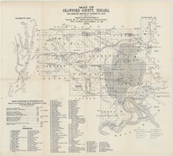
- Subject:
- Topical Subject: IGS Annual Reports, Topical Subject: Coal mines and mining, Geographic Subject: Crawford County (Ind.), Geographic Subject: Wyandotte Cave (...
- Creator:
- Collett, John, 1828-1899
- Publisher:
- Indiana. Geological Survey
- Date Created:
- 1879
- Identifier:
- VAC3073-M-01546
- Genre:
- Thematic maps
- Geographic Location:
- Coordinates: W0863746 W0861445 N0382324 N0380600
- Related URL:
- Catalog URL: https://iucat.iu.edu/catalog/18349479
- Abstract:
- Prepared for 10th annual report of Prof. E.T. Cox, State Geologist by John Collett, 1878. Relief shown by hachures. Shows cities and towns, railroads, cavern...
- Call Number:
- G4093.C7C5 1878 .C6
- Caption:
- Imprint: [Indianapolis] : [Geological Survey of Indiana], [1879] and Imprint: [Indianapolis] : [Indianapolis Journal Company, State printers], [1879]
- Physical Description:
- Scale: Approximately 1:125,000 and Dimensions: on sheet 39 x 44 cm
- Alternate Identifier:
- Title Control Number: a18349479 and Alternate ID: 390723IP
- Persistent URL:
- https://purl.dlib.indiana.edu/iudl/images/VAC3073/VAC3073-M-01546
- Provenance:
- 8th, 9th, and 10th Annual Reports (1876, 1877, 1878) / Indiana. Geological Survey.
-
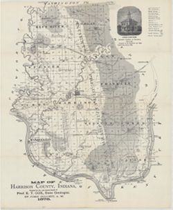
- Subject:
- Topical Subject: Mines and mineral resources, Topical Subject: IGS Annual Reports, Geographic Subject: Harrison County (Ind.), Topical Subject: Corydon Capit...
- Creator:
- Collett, John, 1828-1899
- Publisher:
- Indiana. Geological Survey
- Date Created:
- 1879
- Identifier:
- VAC3073-M-01554
- Genre:
- Geological maps
- Geographic Location:
- Coordinates: W0861951 W0855359 N0382520 N0375731
- Related URL:
- Catalog URL: https://iucat.iu.edu/catalog/18363798
- Abstract:
- Prepared for the 10th annual report of Prof. E.T. Cox, State Geologist by John Collett, 1878. Relief shown by hachures. Shows cities and towns, railroads, sp...
- Call Number:
- G4093.H4C5 1878 .C6
- Caption:
- Imprint: [Indianapolis] : [Geological Survey of Indiana], [1879] and Imprint: [Indianapolis] : [Indianapolis Journal Company, State printers], [1879]
- Physical Description:
- Dimensions: on sheet 44 x 36 cm and Scale: Approximately 1:130,000
- Alternate Identifier:
- Alternate ID: 390723IP and Title Control Number: a18363798
- Persistent URL:
- https://purl.dlib.indiana.edu/iudl/images/VAC3073/VAC3073-M-01554
- Provenance:
- 8th, 9th, and 10th Annual Reports (1876, 1877, 1878) / Indiana. Geological Survey.
-
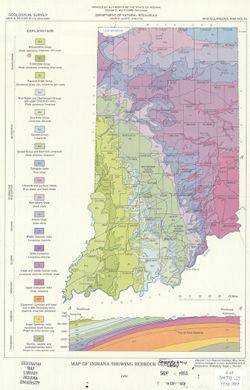
- Subject:
- Geographic Subject: Indiana and Topical Subject: Geology
- Creator:
- Purcell, Roger L.
- Publisher:
- Indiana. Geological Survey
- Date Created:
- 1970
- Identifier:
- VAC3073-M-00975
- Genre:
- Geological maps
- Geographic Location:
- Coordinates: W0880500 W0844700 N0414500 N0374600
- Related URL:
- Catalog URL: https://iucat.iu.edu/catalog/5363412
- Abstract:
- Includes geological cross-section.
- Call Number:
- G4091 .C5 1970 .P87
- Caption:
- Imprint: Indianapolis, Ind. : Indiana Geological Survey, 1970.
- Physical Description:
- Scale: 1:1,800,000 and Dimensions: 31 x 22 cm
- Alternate Identifier:
- Title Control Number: a5363412
- Persistent URL:
- https://purl.dlib.indiana.edu/iudl/images/VAC3073/VAC3073-M-00975
-
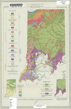
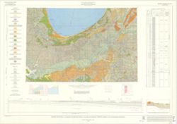
- Subject:
- Topical Subject: Sediments (Geology), Topical Subject: Geology, and Geographic Subject: Indiana
- Creator:
- Indiana. Geological Survey
- Publisher:
- Indiana. Geological Survey
- Date Created:
- 1979
- Identifier:
- VAC3073-M-00675
- Genre:
- Geological maps
- Geographic Location:
- Coordinates: W0880500 W0844700 N0414500 N0374600
- Related URL:
- Catalog URL: https://iucat.iu.edu/catalog/4459811
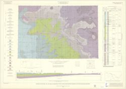
- Abstract:
- "Modified from Regional Geologic Map Series, Indiana Geological Survey." Includes insets of "Thickness of unconsolidated materials" and &...
- Call Number:
- G4091 .C5 1979 .I5
- Caption:
- Imprint: [Bloomington, Ind.] : The Survey, 1979.
- Physical Description:
- Dimensions: 31 x 22 cm and Scale: 1:1,900,000
- Alternate Identifier:
- Title Control Number: a4459811
- Persistent URL:
- https://purl.dlib.indiana.edu/iudl/images/VAC3073/VAC3073-M-00675
-
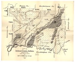
- Subject:
- Geographic Subject: Jackson County (Ind.), Topical Subject: Geology, and Topical Subject: IGS Annual Reports
- Creator:
- Cox, E. T. (Edward Travers), 1821-1907
- Publisher:
- Indiana. Geological Survey
- Date Created:
- 1875
- Identifier:
- VAC3073-M-01177
- Genre:
- Geological maps
- Geographic Location:
- Coordinates: W0861905 W0854741 N0390414 N0384329
- Related URL:
- Catalog URL: https://iucat.iu.edu/catalog/18318685
- Abstract:
- Prepared for the sixth annual report of E[.]T. Cox, State Geologist, 1874. Relief shown by hachures. Shows cities and towns, railroads, geology of the region...
- Call Number:
- G4093.J2C5 1874 .C6
- Caption:
- Imprint: [Indianapolis] : [Geological Survey of Indiana], [1875] and Imprint: [Indianapolis] : [Sentinel Co., printers], [1875]
- Physical Description:
- Scale: Approximately 1:130,000 and Dimensions: on sheet 40 x 47 cm
- Alternate Identifier:
- Title Control Number: a18318685 and Alternate ID: 390723IP
- Persistent URL:
- https://purl.dlib.indiana.edu/iudl/images/VAC3073/VAC3073-M-01177
- Provenance:
- 6th Annual Report (1874) / Indiana. Geological Survey.
-
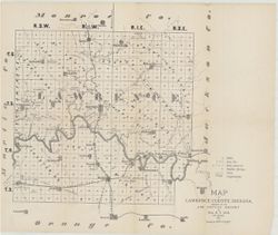
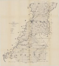
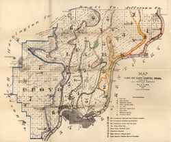
- Subject:
- Topical Subject: Mines and mineral resources, Topical Subject: Caves, Geographic Subject: Lawrence County (Ind.), Topical Subject: Geology, and Topical Subje...
- Creator:
- Collett, John, 1828-1899 and Cox, E. T. (Edward Travers), 1821-1907
- Publisher:
- Indiana. Geological Survey
- Date Created:
- 1874
- Identifier:
- VAC3073-M-01544
- Genre:
- Thematic maps
- Geographic Location:
- Coordinates: W0864107 W0861630 N0385938 N0384112
- Related URL:
- Catalog URL: https://iucat.iu.edu/catalog/18318621
- Abstract:
- Prepared for the 5th Annual Report of Prof. E.T. Cox. 1873. Geology by John Collett. Relief shown by hachures. Shows cities and towns, railroads, mills, cave...
- Call Number:
- G4093.L5C5 1873 .C6
- Caption:
- Imprint: [Indianapolis] : [Sentinel Co., printers], [1874] and Imprint: [Indianapolis] : [Geological Survey of Indiana], [1874]
- Physical Description:
- Scale: Approximately 1:120,000 and Dimensions: on sheet 37 x 44 cm
- Alternate Identifier:
- Title Control Number: a18318621 and Alternate ID: 390723IP
- Persistent URL:
- https://purl.dlib.indiana.edu/iudl/images/VAC3073/VAC3073-M-01544
- Provenance:
- 5th Annual Report (1873) / Indiana. Geological Survey.
-
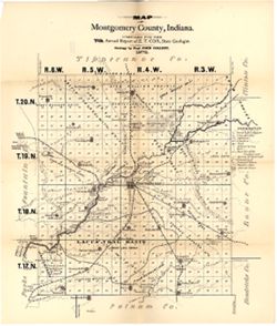
- Subject:
- Topical Subject: Mines and mineral resources, Geographic Subject: Montgomery County (Ind.), Topical Subject: Coal mines and mining, Topical Subject: IGS Annu...
- Creator:
- Collett, John, 1828-1899 and Cox, E. T. (Edward Travers), 1821-1907
- Publisher:
- Indiana. Geological Survey
- Date Created:
- 1876
- Identifier:
- VAC3073-M-01175
- Genre:
- Geological maps
- Geographic Location:
- Coordinates: W0870530 W0864134 N0401301 N0395151
- Related URL:
- Catalog URL: https://iucat.iu.edu/catalog/18349279
- Abstract:
- Compiled for the 7th annual report of E.T. Cox, State Geologist , geology by Prof. John Collett, 1875. Relief shown by hachures. Shows cities and towns, rail...
- Call Number:
- G4093.M8C5 1875 .C6
- Caption:
- Imprint: [Indianapolis] : [Geological Survey of Indiana], [1876] and Imprint: [Indianapolis] : [Sentinel Company, printers], [1876]
- Physical Description:
- Scale: Approximately 1:120,000 and Dimensions: on sheet 48 x 40 cm
- Alternate Identifier:
- Alternate ID: 390723IP and Title Control Number: a18349279
- Persistent URL:
- https://purl.dlib.indiana.edu/iudl/images/VAC3073/VAC3073-M-01175
- Provenance:
- 7th Annual Report (1875) / Indiana. Geological Survey.
-
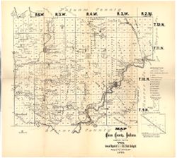
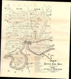
- Subject:
- Geographic Subject: Owen County (Ind.), Topical Subject: IGS Annual Reports, Topical Subject: Geology, Topical Subject: Mines and mineral resources, and Topi...
- Creator:
- Collett, John, 1828-1899
- Publisher:
- Indiana. Geological Survey
- Date Created:
- 1876
- Identifier:
- VAC3073-M-01176
- Genre:
- Geological maps
- Geographic Location:
- Coordinates: W0870316 W0863751 N0392824 N0390957
- Related URL:
- Catalog URL: https://iucat.iu.edu/catalog/18349290
- Abstract:
- Compiled for the 7th annual report of E.T. Cox, State Geologist , geology by Prof. John Collett, 1875. Relief shown by hachures. Shows cities and towns, rail...
- Call Number:
- G4093.O8C5 1875 .C6
- Caption:
- Imprint: [Indianapolis] : [Geological Survey of Indiana], [1876] and Imprint: [Indianapolis] : [Sentinel Co., printers], [1876]
- Physical Description:
- Scale: Approximately 1:130,000 and Dimensions: on sheet 40 x 45 cm
- Alternate Identifier:
- Title Control Number: a18349290 and Alternate ID: 390723IP
- Persistent URL:
- https://purl.dlib.indiana.edu/iudl/images/VAC3073/VAC3073-M-01176
- Provenance:
- 7th Annual Report (1875) / Indiana. Geological Survey.
-
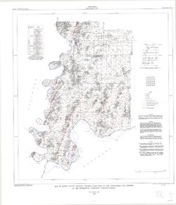
- Subject:
- Topical Subject: Coal, Topical Subject: Geology, Stratigraphic, Topical Subject: Geology, and Geographic Subject: Posey County (Ind.)
- Creator:
- Ault, Curtis H.
- Publisher:
- Indiana. Geological Survey
- Date Created:
- 1997
- Identifier:
- VAC3073-M-00334
- Genre:
- Mine maps
- Geographic Location:
- Coordinates: W0880600 W0874100 N0381400 N0374600
- Related URL:
- Catalog URL: https://iucat.iu.edu/catalog/4995833
- Abstract:
- Coordinates printed at top and lower margin are incorrect. Includes index map, text, and sectionized township diagram.
- Call Number:
- G4093.P6 H9 1997 .A9
- Caption:
- Imprint: [Bloomington, Ind.] : Indiana University, Indiana Geological Survey, 1997.
- Physical Description:
- Dimensions: 86 x 79 cm and Scale: 1:66,000
- Alternate Identifier:
- Title Control Number: a4995833
- Persistent URL:
- https://purl.dlib.indiana.edu/iudl/images/VAC3073/VAC3073-M-00334
-
- Subject:
- Geographic Subject: Vanderburgh County (Ind.), Topical Subject: Coal mines and mining, Topical Subject: Mines and mineral resources, Topical Subject: Geology...
- Creator:
- Collett, John, 1828-1899
- Publisher:
- Indiana. Geological Survey
- Date Created:
- 1876
- Identifier:
- VAC3073-M-01146
- Genre:
- Geological maps
- Geographic Location:
- Coordinates: W0874203 W0872658 N0381006 N0374933
- Related URL:
- Catalog URL: https://iucat.iu.edu/catalog/18349316
- Abstract:
- Compiled for the 7th annual report of E.T. Cox, State Geologist , geology by Prof. John Collett, 1875. Relief shown by hachures. Shows cities and towns, rail...
- Call Number:
- G4093.V3C5 1875 .C6
- Caption:
- Imprint: [Indianapolis] : [Geological Survey of Indiana], [1876] and Imprint: [Indianapolis] : [Sentinel Company, printers], [1876]
- Physical Description:
- Scale: Approximately 1:130,000 and Dimensions: on sheet 41 x 31 cm
- Alternate Identifier:
- Alternate ID: 390723IP and Title Control Number: a18349316
- Persistent URL:
- https://purl.dlib.indiana.edu/iudl/images/VAC3073/VAC3073-M-01146
- Provenance:
- 7th Annual Report (1875) / Indiana. Geological Survey.
-
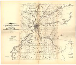
- Subject:
- Topical Subject: Coal mines and mining, Geographic Subject: Vigo County (Ind.), Topical Subject: Geology, and Topical Subject: IGS Annual Reports
- Creator:
- Cox, E. T. (Edward Travers), 1821-1907
- Publisher:
- Indiana. Geological Survey
- Date Created:
- 1876
- Identifier:
- VAC3073-M-01174
- Genre:
- Geological maps
- Geographic Location:
- Coordinates: W0873635 W0871156 N0393634 N0391532
- Related URL:
- Catalog URL: https://iucat.iu.edu/catalog/18349323
- Abstract:
- Compiled for the seventh annual report of E.T. Cox, State Geologist , geology by Prof. E.T. Cox, 1875. Shows cities and towns, railroads, coal seams and outc...
- Call Number:
- G4093.V5C5 1875 .C6
- Caption:
- Imprint: [Indianapolis] : [Sentinel Company, printers], [1876] and Imprint: [Indianapolis] : [Geological Survey of Indiana], [1876]
- Physical Description:
- Scale: Approximately 1:120,000 and Dimensions: on sheet 39 x 45 cm
- Alternate Identifier:
- Title Control Number: a18349323 and Alternate ID: 390723IP
- Persistent URL:
- https://purl.dlib.indiana.edu/iudl/images/VAC3073/VAC3073-M-01174
- Provenance:
- 7th Annual Report (1875) / Indiana. Geological Survey.
-
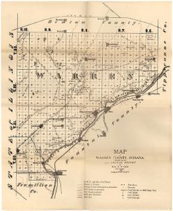
- Subject:
- Topical Subject: Mines and mineral resources, Topical Subject: Geology, Topical Subject: IGS Annual Reports, Geographic Subject: Warren County (Ind.), and To...
- Creator:
- Collett, John, 1828-1899
- Publisher:
- Indiana. Geological Survey
- Date Created:
- 1873
- Identifier:
- VAC3073-M-01171
- Genre:
- Geological maps
- Geographic Location:
- Coordinates: W0873200 W0870600 N0402800 N0400700
- Related URL:
- Catalog URL: https://iucat.iu.edu/catalog/15734000
- Abstract:
- Relief shown by hachures. Shows cities and towns, operating and proposed railroads, prairies, test bores, deposits of iron ore and mill stone grit, mills, qu...
- Call Number:
- G4093.W3C5 1873 .C6
- Caption:
- Imprint: [Indianapolis] : [Sentinel Company, printers], [1874]
- Physical Description:
- Scale: Approximately 1:120,000 and Dimensions: 44 x 36 cm
- Alternate Identifier:
- Title Control Number: a15734000 and Alternate ID: 390723IP
- Persistent URL:
- https://purl.dlib.indiana.edu/iudl/images/VAC3073/VAC3073-M-01171
- Provenance:
- 5th Annual Report (1873) / Indiana. Geological Survey.
-
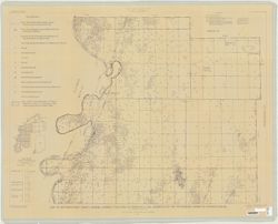
- Subject:
- Topical Subject: Geology, Geographic Subject: Posey County (Ind.), and Topical Subject: Geology, Stratigraphic
- Creator:
- Tanner, George F. (George Frederick), 1953-
- Publisher:
- Indiana. Geological Survey
- Date Created:
- 1981
- Identifier:
- VAC3073-M-01182
- Genre:
- Geological maps and Thematic maps
- Geographic Location:
- Coordinates: W0880552 W0874117 N0381349 N0374618
- Related URL:
- Catalog URL: https://iucat.iu.edu/catalog/5337575
- Call Number:
- G4093.P6C57 1981 .T31
- Caption:
- Imprint: [Bloomington] : Indiana Geological Survey, 1981
- Physical Description:
- Dimensions: 82 x 114 cm and Scale: 1:32,000
- Persistent URL:
- https://purl.dlib.indiana.edu/iudl/images/VAC3073/VAC3073-M-01182
-
- Subject:
- Geographic Subject: Indiana, Northwest, Geographic Subject: Michigan, Geographic Subject: Calumet Region (Ill. and Ind.), Geographic Subject: Illinois, Topic...
- Publisher:
- Indiana. Geological Survey
- Date Created:
- 1961
- Identifier:
- VAC3073-M-00958
- Genre:
- Geological maps
- Related URL:
- Catalog URL: https://iucat.iu.edu/catalog/5289775
- Abstract:
- Color maps 66 x 102cm.
- Call Number:
- G4091 .C5 s250 .I5
- Caption:
- Imprint: [Bloomington, In] 1961-
- Physical Description:
- Scale: 1:250,000 and Dimensions: col. maps 66 x 102 cm.
- Alternate Identifier:
- Title Control Number: CAF2153BB
- Persistent URL:
- https://purl.dlib.indiana.edu/iudl/images/VAC3073/VAC3073-M-00958
- Provenance:
- Regional geologic map.
