Search Constraints

You searched for: Publisher Indiana. Geological Survey Remove constraint Publisher: Indiana. Geological Survey Subject Geographic Subject: Indiana Remove constraint Subject: Geographic Subject: Indiana
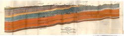
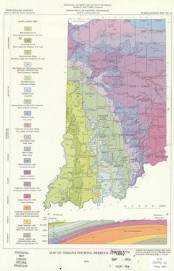
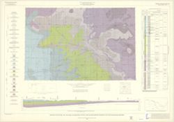
Search Results

  • [Coal measure sections in Indiana, Southern Illinois, and Western Kentucky]
  • Vertical section of the geological formations from Green Castle to Terre Haute : made from outcrops and sections of bores along the line of T.H. & I.R. Railroad
  • Section from the west edge of Martin Co. to Rockford in Jackson Co., passing on or near the line of the Ohio and Mississippi Railway
  • Regional geologic map. Danville
  • Regional geologic map. Chicago
  • Map showing selected subsurface dye traces in south-central Indiana
  • Map showing oil, gas, and gas storage fields in Indiana
  • Map showing location of industrial sand, marl, peat, mineral wool, cement, and lime operations in Indiana
  • Map showing location of clay and shale pits and ceramic plants in Indiana
  • Map of southwestern Indiana showing locations of surface and underground coal mines
  • Map of Southwestern Indiana showing locations of coal slurry ponds and preparation plants
  • Map of Southwestern Indiana showing locations of active coal mines
  • Map of Southwestern Indiana showing locations of active coal mines
  • Map of Southwestern Indiana showing locations of active coal mines
  • Map of Southwestern Indiana showing areas underground mined for coal
  • Map of Southwestern Indiana showing areas strip mined for coal
  • Map of Indiana showing unconsolidated deposits
  • Map of Indiana showing production and flow of coal, and location of electric generating plants consuming coal
  • Map of Indiana showing oil, gas, and products pipelines
  • Map of Indiana showing locations of coal and industrial minerals operations
  • Map of Indiana showing location of active coal mines
  • Map of Indiana showing county boundaries, township and range lines
  • Map of Indiana showing county boundaries, township and range lines
  • Map of Indiana showing bedrock geology
  • Locations of clay and shale operations in Indiana
  • Glacial geology of Indiana
  • Geological map of the 1¬¨‚àû x 2¬¨‚àû Chicago Quadrangle, Indiana, Illinois, and Michigan, showing bedrock and unconsolidated deposits
  • Geologic map of the Indianapolis 1¬¨‚àû x 2¬¨‚àû quadrangle, Indiana and Illinois, showing bedrock and unconsolidated deposits
  • Geologic map of the 1¬¨‚àû x 2¬¨‚àû Vincennes Quadrangle and parts of adjoining quadrangles, Indiana and Illinois, showing bedrock and unconsolidated deposits
  • Geologic map of the 1¬¨‚àû x 2¬¨‚àû Vincennes Quadrangle and parts of adjoining quadrangles, Indiana and Illinois, showing bedrock and unconsolidated deposits
  • Geologic map of the 1¬¨‚àû x 2¬¨‚àû Muncie Quadrangle, Indiana and Ohio, showing bedrock and unconsolidated deposits
  • Geologic map of the 1¬¨‚àû x 2¬¨‚àû Louisville quadrangle, Indiana, showing bedrock and unconsolidated deposits
  • Geologic map of the 1¬¨‚àû x 2¬¨‚àû Indianapolis quadrangle, Indiana and Illinois, showing bedrock and unconsolidated deposits
  • Geologic map of the 1¬¨‚àû x 2¬¨‚àû Fort Wayne quadrangle, Indiana, Michigan, and Ohio, showing bedrock and unconsolidated deposits
  • Geologic map of the 1¬¨‚àû x 2¬¨‚àû Danville quadrangle, Indiana and Illinois, showing bedrock and unconsolidated deposits
  • Geologic map of the 1¬¨‚àû x 2¬¨‚àû Cincinnati Quadrangle, Indiana and Ohio, showing bedrock and unconsolidated deposits
  • Geologic map of Indiana
  • Generalized bedrock map of Southern Indiana
  • Distribution of sinkholes and sinking-stream basins with locations of cave openings in Central Southern Indiana
  • Atlas of mineral resources of Indiana
  • Areas of sinkholes and sinking-stream basins with locations of cave openings and springs in Central Southern Indiana
  • Ancient shorelines of Southwestern Lake Michigan