
Search Constraints
You searched for:
Publisher
Indiana. Department of Geology and Natural Resources
Remove constraint Publisher: Indiana. Department of Geology and Natural Resources
« Previous |
1 - 20 of 196
|
Next »
Search Results
-
- Subject:
- Topical Subject: IGS Annual Reports, Topical Subject: Road materials, Topical Subject: Gravel, Topical Subject: Quarries and quarrying, and Geographic Subjec...
- Publisher:
- Indiana. Department of Geology and Natural Resources
- Date Created:
- 1906
- Identifier:
- VAC3073-M-01589
- Genre:
- Thematic maps
- Geographic Location:
- Coordinates: W0864109 W0861450 N0393801 N0392020
- Related URL:
- Catalog URL: https://iucat.iu.edu/catalog/18299115
- Abstract:
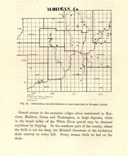
- Alternate title: Morgan Co. Title from caption. At head of title: Fig. 45. Detached from: The roads and road materials of a portion of southwestern Indian...
- Call Number:
- G4093.M9H5 1905 .M67
- Caption:
- Imprint: [Indianapolis] : [Indiana Dept. of Geology and Natural Resources], [1906]
- Physical Description:
- Scale: Approximately 1:366,300 and Dimensions: on sheet 17 x 14 cm
- Alternate Identifier:
- Alternate ID: 390726IP and Title Control Number: a18299115
- Persistent URL:
- https://purl.dlib.indiana.edu/iudl/images/VAC3073/VAC3073-M-01589
- Provenance:
- 30th Annual Report (1905) / Indiana. Department of Geology and Natural Resources.
-
- Subject:
- Geographic Subject: Huntingburg Region (Ind.), Topical Subject: Clay, Topical Subject: IGS Annual Reports, Geographic Subject: Dubois County (Ind.), and Topi...
- Creator:
- Blatchley, Raymond S. (Raymond Sillliman)
- Publisher:
- Indiana. Department of Geology and Natural Resources
- Date Created:
- 1905
- Identifier:
- VAC3073-M-01587
- Genre:
- Geological maps
- Geographic Location:
- Coordinates: W0865919 W0865616 N0381927 N0381621
- Related URL:
- Catalog URL: https://iucat.iu.edu/catalog/18282191
- Abstract:
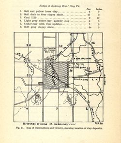
- Shows locations of clay deposits and local brick and tile companies. Also includes listings of measurements for the Bockting Bros.' clay pit. "Fig....
- Call Number:
- G4094.H8H5 1904 .M37
- Caption:
- Imprint: [Indianapolis] : [Wm. B. Burford], [1905] and Imprint: [Indianapolis] : [Indiana Department of Geology and Natural Resources], [1905]
- Physical Description:
- Scale: Approximately 1:46,650 and Dimensions: on sheet 17 x 14 cm
- Alternate Identifier:
- Alternate ID: 390726IP and Title Control Number: a18282191
- Persistent URL:
- https://purl.dlib.indiana.edu/iudl/images/VAC3073/VAC3073-M-01587
- Provenance:
- 29th Annual Report (1904) / Indiana. Department of Geology and Natural Resources.
-
- Subject:
- Geographic Subject: Brazil (Ind.), Topical Subject: IGS Annual Reports, Topical Subject: Clay industries, and Topical Subject: Clay
- Creator:
- Blatchley, Raymond S. (Raymond Sillliman)
- Publisher:
- Indiana. Department of Geology and Natural Resources
- Date Created:
- 1905
- Identifier:
- VAC3073-M-01586
- Genre:
- Geological maps
- Geographic Location:
- Coordinates: W0870852 W0870554 N0393212 N0393014
- Related URL:
- Catalog URL: https://iucat.iu.edu/catalog/18279473
- Abstract:
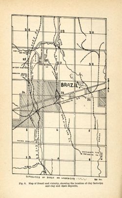
- Title from caption. "Fig. 8." "RSB DEL." Shows locations of clay deposits as well as mining, clay works, brick, and sewer pipe companies....
- Call Number:
- G4093.P2H5 1904 .B75
- Caption:
- Imprint: [Indianapolis] : [Wm. B. Burford], [1905] and Imprint: [Indianapolis] : [Indiana Department of Geology and Natural Resources], [1905]
- Physical Description:
- Scale: Approximately 1:46,650 and Dimensions: on sheet 22 x 14 cm
- Alternate Identifier:
- Title Control Number: a18279473 and Alternate ID: 390726IP
- Persistent URL:
- https://purl.dlib.indiana.edu/iudl/images/VAC3073/VAC3073-M-01586
- Provenance:
- 29th Annual Report (1904) / Indiana. Department of Geology and Natural Resources.
-
- Subject:
- Geographic Subject: Bridgeton Region (Ind.), Topical Subject: Mines and mineral resources, Geographic Subject: Parke County (Ind.), Topical Subject: IGS Annu...
- Publisher:
- Indiana. Department of Geology and Natural Resources
- Date Created:
- 1905
- Identifier:
- VAC3073-M-01585
- Genre:
- Geological maps
- Geographic Location:
- Coordinates: W0871115 W0870900 N0394130 N0393800
- Related URL:
- Catalog URL: https://iucat.iu.edu/catalog/18279221
- Abstract:
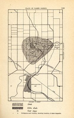
- Shows location of shale, extra shale, and coal slope. "Clays of Parke County." Detached from: The clays and clay industries of Indiana / W. S. B...
- Call Number:
- G4093.P2H5 1904 .B75
- Caption:
- Imprint: [Indianapolis] : [Indiana Department of Geology and Natural Resources], [1905] and Imprint: [Indianapolis] : [Wm. B. Burford], [1905]
- Physical Description:
- Scale: Scale not given. and Dimensions: on sheet 22 x 14 cm
- Alternate Identifier:
- Alternate ID: 390726IP and Title Control Number: a18279221
- Persistent URL:
- https://purl.dlib.indiana.edu/iudl/images/VAC3073/VAC3073-M-01585
- Provenance:
- 29th Annual Report (1904) / Indiana. Department of Geology and Natural Resources.
-
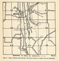
- Subject:
- Geographic Subject: Mecca Region (Ind.), Topical Subject: Clay, Topical Subject: Clay industries, Topical Subject: Shale, Geographic Subject: Parke County (I...
- Creator:
- Blatchley, Raymond S. (Raymond Sillliman)
- Publisher:
- Indiana. Department of Geology and Natural Resources
- Date Created:
- 1905
- Identifier:
- VAC3073-M-01584
- Genre:
- Geological maps
- Geographic Location:
- Coordinates: W0872106 W0871741 N0394423 N0394217
- Related URL:
- Catalog URL: https://iucat.iu.edu/catalog/18282202
- Abstract:
- Title from caption. Shows locations of shale and clay deposits, clay mines, and local brick and clay works companies. Also includes listing of measurements f...
- Call Number:
- G4093.P2H5 1904 .M37
- Caption:
- Imprint: [Indianapolis] : [Indiana Department of Geology and Natural Resources ], [1905] and Imprint: [Indianapolis] : [Wm. B. Burford], [1905]
- Physical Description:
- Dimensions: on sheet 12 x 12 cm and Scale: Approximately 1:46,650
- Alternate Identifier:
- Alternate ID: 390726IP and Title Control Number: a18282202
- Persistent URL:
- https://purl.dlib.indiana.edu/iudl/images/VAC3073/VAC3073-M-01584
- Provenance:
- 29th Annual Report (1904) / Indiana. Department of Geology and Natural Resources.
-
![Map No. 4 showing locations of upper & lower dams [Winona Lake Region, Indiana]](https://iiif.uits.iu.edu/iiif/2/3j3345867%2Ffiles%2Fcfcf70eb-0483-44d3-b9ee-e305909b40f2/full/250,/0/default.jpg)
- Subject:
- Geographic Subject: Kosciusko County (Ind.), Geographic Subject: Winona Lake Region (Ind. : Lake), Topical Subject: IGS Annual Reports, and Topical Subject: ...
- Publisher:
- Indiana. Department of Geology and Natural Resources
- Date Created:
- 1904
- Identifier:
- VAC3073-M-01583
- Genre:
- Topographic maps and Geological cross-sections
- Geographic Location:
- Coordinates: W0855154 W0855032 N0411406 N0411308
- Related URL:
- Catalog URL: https://iucat.iu.edu/catalog/18418357
- Abstract:
- Relief shown by contours and profile. Shows location of dams on Winona Lake outlet near Warsaw in Kosciusko County, Indiana, and cross-sections of upper and ...
- Call Number:
- G4093.K6N2 1903 .M3
- Caption:
- Imprint: [Indianapolis] : [Wm. B. Burford], [1904] and Imprint: [Indianapolis] : [Indiana Department of Geology and Natural Resources], [1904]
- Physical Description:
- Dimensions: on sheet 10 x 10 cm and Scale: Approximately 1:20,100. Vertical scale varies
- Alternate Identifier:
- Title Control Number: a18418357 and Alternate ID: 390726IP
- Persistent URL:
- https://purl.dlib.indiana.edu/iudl/images/VAC3073/VAC3073-M-01583
- Provenance:
- 28th Annual Report (1903) / Indiana. Department of Geology and Natural Resources.
-
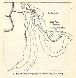
- Subject:
- Topical Subject: IGS Annual Reports, Geographic Subject: Cherry Creek (Ind.), and Topical Subject: Rivers
- Publisher:
- Indiana. Department of Geology and Natural Resources
- Date Created:
- 1904
- Identifier:
- VAC3073-M-01580
- Genre:
- Maps
- Related URL:
- Catalog URL: new.iucat.iu.edu/catalog/4022271
- Call Number:
- QE109 .A2 1903
- Caption:
- Imprint: Indianapolis : 1904.
- Persistent URL:
- https://purl.dlib.indiana.edu/iudl/images/VAC3073/VAC3073-M-01580
- Provenance:
- 28th Annual Report (1903) / Indiana. Department of Geology and Natural Resources.
-
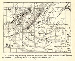
- Subject:
- Geographic Subject: Indiana, Topical Subject: Moraines, Geographic Subject: Ohio, and Topical Subject: IGS Annual Reports
- Creator:
- Dryer, Charles Redway, 1850-1927
- Publisher:
- Indiana. Department of Geology and Natural Resources
- Date Created:
- 1904
- Identifier:
- VAC3073-M-01578
- Genre:
- Geological maps
- Geographic Location:
- Coordinates: W0860630 W0832600 N0415400 N0401530
- Related URL:
- Catalog URL: https://iucat.iu.edu/catalog/18418361
- Abstract:
- Caption title: Glacial map showing moraines in which Lake Eagle and the city of Warsaw are located. Relief shown by profile. Includes geological profile of r...
- Call Number:
- QE109 .A2 1903
- Caption:
- Imprint: [Indianapolis] : [Wm. B. Burford], [1904] and Imprint: [Indianapolis] : [Indiana Department of Geology and Natural Resources], [1904]
- Physical Description:
- Dimensions: 8 x 11 cm and Scale: Approximately 1:2,476,000. Vertical scale indeterminable
- Alternate Identifier:
- Alternate ID: 390726IP and Title Control Number: a18418361
- Persistent URL:
- https://purl.dlib.indiana.edu/iudl/images/VAC3073/VAC3073-M-01578
- Provenance:
- 28th Annual Report (1903) / Indiana. Department of Geology and Natural Resources.
-
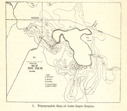
- Subject:
- Topical Subject: Lakes, Geographic Subject: Winona Lake (Ind. : Lake), Geographic Subject: Warsaw (Ind.), and Topical Subject: IGS Annual Reports
- Publisher:
- Indiana. Department of Geology and Natural Resources
- Date Created:
- 1904
- Identifier:
- VAC3073-M-01577
- Genre:
- Topographic maps
- Related URL:
- Catalog URL: new.iucat.iu.edu/catalog/4022271
- Call Number:
- QE109 .A2 1903
- Caption:
- Imprint: Indianapolis : 1904.
- Persistent URL:
- https://purl.dlib.indiana.edu/iudl/images/VAC3073/VAC3073-M-01577
- Provenance:
- 28th Annual Report (1903) / Indiana. Department of Geology and Natural Resources.
-
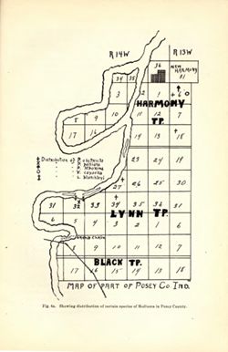
- Subject:
- Topical Subject: IGS Annual Reports, Geographic Subject: New Harmony (Ind.), and Geographic Subject: Posey County (Ind.)
- Publisher:
- Indiana. Department of Geology and Natural Resources
- Date Created:
- 1903
- Identifier:
- VAC3073-M-01576
- Genre:
- Thematic maps
- Related URL:
- Catalog URL: new.iucat.iu.edu/catalog/4022271
- Call Number:
- QE109 .A2 1902
- Caption:
- Imprint: Indianapolis : 1903.
- Physical Description:
- Scale: Scale not given.
- Persistent URL:
- https://purl.dlib.indiana.edu/iudl/images/VAC3073/VAC3073-M-01576
-
- Subject:
- Geographic Subject: Indiana and Topical Subject: IGS Annual Reports
- Publisher:
- Indiana. Department of Geology and Natural Resources
- Date Created:
- 1902
- Identifier:
- VAC3073-M-01575
- Genre:
- Index maps
- Geographic Location:
- Coordinates: W0880500 W0844700 N0414500 N0374600
- Related URL:
- Catalog URL: https://iucat.iu.edu/catalog/18418335
- Abstract:
- Index map showing locations covered by topographic maps represented on plates II-IV of the article. Shading indicates area covered by Topographic Section (Pl...
- Call Number:
- G4090 1901 .S5
- Caption:
- Imprint: [Indianapolis] : [Indiana Department of Geology and Natural Resources], [1902] and Imprint: [Indianapolis] : [Wm. B. Burford], [1902]
- Physical Description:
- Scale: Approximately 1:2,299,000 and Dimensions: on sheet 22 x 15 cm
- Alternate Identifier:
- Title Control Number: a18418335 and Alternate ID: 390726IP
- Persistent URL:
- https://purl.dlib.indiana.edu/iudl/images/VAC3073/VAC3073-M-01575
- Provenance:
- 26th Annual Report (1901) / Indiana. Department of Geology and Natural Resources.
-
- Subject:
- Geographic Subject: Indiana, Topical Subject: IGS Annual Reports, and Topical Subject: Orthoptera--Collection and preservation
- Creator:
- Blatchley, W. S. (Willis Stanley), 1859-1940
- Publisher:
- Indiana. Department of Geology and Natural Resources
- Date Created:
- 1903
- Identifier:
- VAC3073-M-01574
- Genre:
- Thematic maps
- Geographic Location:
- Coordinates: W0880500 W0844700 N0414500 N0374600
- Related URL:
- Catalog URL: https://iucat.iu.edu/catalog/18418335
- Abstract:
- At head of title: "Fig. 1." Detached from: The Orthoptera of Indiana / by W. S. Blatchley. In Indiana Department of Geology and Natural Resource...
- Call Number:
- G4091.D4 1902 .B5
- Caption:
- Imprint: Indianapolis : Wm. B. Burford, [1903] and Imprint: [Indianapolis] : [Indiana Department of Geology and Natural Resouces], [1903]
- Physical Description:
- Scale: Approximately 1:2,850,000
- Alternate Identifier:
- Title Control Number: a18418335
- Persistent URL:
- https://purl.dlib.indiana.edu/iudl/images/VAC3073/VAC3073-M-01574
- Provenance:
- 27th Annual Report (1902) / Indiana. Department of Geology and Natural Resources.
-
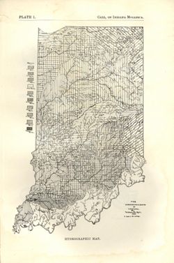
- Subject:
- Topical Subject: Watersheds and Geographic Subject: Indiana
- Creator:
- Call, Richard Ellsworth, 1856-1917
- Publisher:
- Indiana. Department of Geology and Natural Resources
- Date Created:
- 1900
- Identifier:
- VAC3073-M-01572
- Genre:
- Maps
- Geographic Location:
- Coordinates: W0880500 W0844700 N0414500 N0374600
- Related URL:
- Catalog URL: https://iucat.iu.edu/catalog/18418197
- Abstract:
- At foot of map: "Hydrographic map." At head of map: "Plate 1 -- Call, On Indiana mollusca." Detached from: A descriptive illustrated cata...
- Call Number:
- G4091.C315 1896 .C3
- Caption:
- Imprint: [Indianapolis] : [Department of Geology and Natural Resources], [1900] and Imprint: [Indianapolis] : [Wm. B. Burford], [1900]
- Physical Description:
- Dimensions: on sheet 22 x 15 cm and Scale: Approximately 1:1,267,200. 1 inch = 20 miles
- Alternate Identifier:
- Alternate ID: 390726IP and Title Control Number: a18418197
- Persistent URL:
- https://purl.dlib.indiana.edu/iudl/images/VAC3073/VAC3073-M-01572
- Provenance:
- 24th Annual Report (1899) / Indiana. Department of Geology and Natural Resources.
-
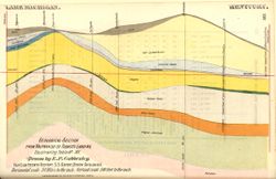
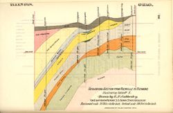
- Subject:
- Topical Subject: Mines and mineral resources, Geographic Subject: Indiana, Topical Subject: IGS Annual Reports, and Topical Subject: Geology, Stratigraphic
- Creator:
- Cubberley, Ellwood P., 1868-1941
- Publisher:
- Indiana. Department of Geology and Natural Resources
- Date Created:
- 1894
- Identifier:
- VAC3073-M-01571
- Genre:
- Geological cross-sections
- Geographic Location:
- Coordinates: W0873400 W0870100 N0414000 N0383900
- Related URL:
- Catalog URL: https://iucat.iu.edu/catalog/18224924
- Abstract:
- Geological cross section showing stratigraphy of mineral resources, including various coal, limestone, and shale layers. Relative relief in relation to sea l...
- Call Number:
- G4091.C57 1893 .C83, no. 16
- Caption:
- Imprint: Indpls : lithographed by William B. Burford, [1894] and Imprint: [Indianapolis] : [Indiana, Dept. of Geology and Natural Resources], [1894]
- Physical Description:
- Dimensions: 15 x 23 cm and Scale: Approximately 1:1,900,800. 30 miles to the inch. Vertical scale approximately 1:6,000. 500 feet to the inch
- Alternate Identifier:
- Alternate ID: 390726IP and Title Control Number: a18224924
- Persistent URL:
- https://purl.dlib.indiana.edu/iudl/images/VAC3073/VAC3073-M-01571
- Provenance:
- 18th Annual Report (1893) / Indiana. Department of Geology and Natural Resources.
-
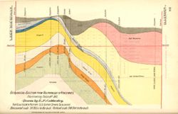
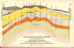
- Subject:
- Topical Subject: IGS Annual Reports, Geographic Subject: Indiana, Topical Subject: Geology, Stratigraphic, and Topical Subject: Mines and mineral resources
- Creator:
- Cubberley, Ellwood P., 1868-1941
- Publisher:
- Indiana. Department of Geology and Natural Resources
- Date Created:
- 1894
- Identifier:
- VAC3073-M-01570
- Genre:
- Geological cross-sections
- Geographic Location:
- Coordinates: W0870500 W0860300 N0414000 N0380000
- Related URL:
- Catalog URL: https://iucat.iu.edu/catalog/18224924
- Abstract:
- Geological cross section showing stratigraphy of mineral resources, including various limestone and shale layers. Relative relief in relation to sea level sh...
- Call Number:
- G4091.C57 1893 .C83, no. 15
- Caption:
- Imprint: Indpls : lithographed by William B. Burford, [1894] and Imprint: [Indianapolis] : [Indiana, Dept. of Geology and Natural Resources], [1894]
- Physical Description:
- Scale: Approximately 1:1,900,800. 30 miles to the inch. Vertical scale approximately 1:6,000. 500 feet to the inch and Dimensions: 15 x 23 cm
- Alternate Identifier:
- Alternate ID: 390726IP and Title Control Number: a18224924
- Persistent URL:
- https://purl.dlib.indiana.edu/iudl/images/VAC3073/VAC3073-M-01570
- Provenance:
- 18th Annual Report (1893) / Indiana. Department of Geology and Natural Resources.
-
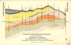
- Subject:
- Geographic Subject: Indiana, Topical Subject: Mines and mineral resources, Topical Subject: Geology, Stratigraphic, and Topical Subject: IGS Annual Reports
- Creator:
- Cubberley, Ellwood P., 1868-1941
- Publisher:
- Indiana. Department of Geology and Natural Resources
- Date Created:
- 1894
- Identifier:
- VAC3073-M-01569
- Genre:
- Geological cross-sections
- Geographic Location:
- Coordinates: W0870605 W0845021 N0413930 N0390428
- Related URL:
- Catalog URL: https://iucat.iu.edu/catalog/18224921
- Abstract:
- Geological cross section showing stratigraphy of mineral resources, including various limestone and shale layers. Relative relief in relation to sea level sh...
- Call Number:
- G4091.C57 1893 .C83, no. 5
- Caption:
- Imprint: Indpls : lithographed by William B. Burford, [1894] and Imprint: [Indianapolis] : [Indiana, Dept. of Geology and Natural Resources], [1894]
- Physical Description:
- Scale: Approximately 1:1,900,800. 30 miles to the inch. Vertical scale approximately 1:6,000. 500 feet to the inch and Dimensions: 15 x 23 cm
- Alternate Identifier:
- Title Control Number: a18224921 and Alternate ID: 390726IP
- Persistent URL:
- https://purl.dlib.indiana.edu/iudl/images/VAC3073/VAC3073-M-01569
- Provenance:
- 18th Annual Report (1893) / Indiana. Department of Geology and Natural Resources.
-
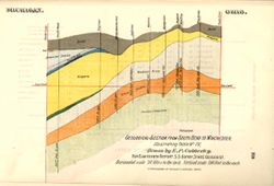
- Subject:
- Topical Subject: IGS Annual Reports, Topical Subject: Mines and mineral resources, Geographic Subject: Indiana, and Topical Subject: Geology, Stratigraphic
- Creator:
- Cubberley, Ellwood P., 1868-1941
- Publisher:
- Indiana. Department of Geology and Natural Resources
- Date Created:
- 1894
- Identifier:
- VAC3073-M-01568
- Genre:
- Geological cross-sections
- Geographic Location:
- Coordinates: W0862100 W0844815 N0414545 N0400900
- Related URL:
- Catalog URL: https://iucat.iu.edu/catalog/18224917
- Abstract:
- Geological cross section showing stratigraphy of mineral resources, including various limestone and shale layers. Relative relief in relation to sea level sh...
- Call Number:
- G4091.C57 1893 .C83, no. 4
- Caption:
- Imprint: [Indianapolis] : [Indiana, Dept. of Geology and Natural Resources], [1894] and Imprint: Indpls : lithographed by William B. Burford, [1894]
- Physical Description:
- Scale: Approximately 1:1,900,800. 30 miles to the inch. Vertical scale approximately 1:6,000. 500 feet to the inch and Dimensions: 15 x 23 cm
- Alternate Identifier:
- Alternate ID: 390726IP and Title Control Number: a18224917
- Persistent URL:
- https://purl.dlib.indiana.edu/iudl/images/VAC3073/VAC3073-M-01568
- Provenance:
- 18th Annual Report (1893) / Indiana. Department of Geology and Natural Resources.
-
- Subject:
- Topical Subject: Geology, Stratigraphic, Geographic Subject: Indiana, Topical Subject: Mines and mineral resources, and Topical Subject: IGS Annual Reports
- Creator:
- Cubberley, Ellwood P., 1868-1941
- Publisher:
- Indiana. Department of Geology and Natural Resources
- Date Created:
- 1894
- Identifier:
- VAC3073-M-01567
- Genre:
- Geological cross-sections
- Geographic Location:
- Coordinates: W0861818 W0854806 N0414542 N0381622
- Related URL:
- Catalog URL: https://iucat.iu.edu/catalog/18224912
- Abstract:
- Geological cross section showing stratigraphy of mineral resources, including various limestone and shale layers. Relative relief in relation to sea level sh...
- Call Number:
- G4091.C57 1893 .C83, no. 14
- Caption:
- Imprint: [Indianapolis] : [Indiana, Dept. of Geology and Natural Resources], [1894] and Imprint: Indpls : lithographed by William B. Burford, [1894]
- Physical Description:
- Dimensions: 15 x 23 cm and Scale: Approximately 1:1,900,800. 30 miles to the inch. Vertical scale approximately 1:6,000. 500 feet to the inch
- Alternate Identifier:
- Title Control Number: a18224912 and Alternate ID: 390726IP
- Persistent URL:
- https://purl.dlib.indiana.edu/iudl/images/VAC3073/VAC3073-M-01567
- Provenance:
- 18th Annual Report (1893) / Indiana. Department of Geology and Natural Resources.
-
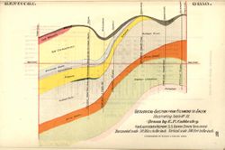
- Subject:
- Topical Subject: Geology, Stratigraphic, Topical Subject: Mines and mineral resources, Topical Subject: IGS Annual Reports, and Geographic Subject: Indiana
- Creator:
- Cubberley, Ellwood P., 1868-1941
- Publisher:
- Indiana. Department of Geology and Natural Resources
- Date Created:
- 1894
- Identifier:
- VAC3073-M-01566
- Genre:
- Geological cross-sections
- Geographic Location:
- Coordinates: W0873200 W0844900 N0395000 N0394500
- Related URL:
- Catalog URL: https://iucat.iu.edu/catalog/18224850
- Abstract:
- Geological cross section showing stratigraphy of mineral resources, including various coal, limestone, and shale layers. Relative relief in relation to sea l...
- Call Number:
- G4091.C57 1893 .C83, no. 10
- Caption:
- Imprint: Indpls : lithographed by William B. Burford, [1894] and Imprint: [Indianapolis] : [Indiana, Dept. of Geology and Natural Resources], [1894]
- Physical Description:
- Scale: Approximately 1:1,900,800. 30 miles to the inch. Vertical scale approximately 1:6,000. 500 feet to the inch and Dimensions: 15 x 23 cm
- Alternate Identifier:
- Title Control Number: a18224850 and Alternate ID: 390726IP
- Persistent URL:
- https://purl.dlib.indiana.edu/iudl/images/VAC3073/VAC3073-M-01566
- Provenance:
- 18th Annual Report (1893) / Indiana. Department of Geology and Natural Resources.
-
- Subject:
- Topical Subject: Mines and mineral resources, Topical Subject: IGS Annual Reports, Geographic Subject: Indiana, and Topical Subject: Geology, Stratigraphic
- Creator:
- Cubberley, Ellwood P., 1868-1941
- Publisher:
- Indiana. Department of Geology and Natural Resources
- Date Created:
- 1894
- Identifier:
- VAC3073-M-01565
- Genre:
- Geological cross-sections
- Geographic Location:
- Coordinates: W0860745 W0844830 N0395315 N0375945
- Related URL:
- Catalog URL: https://iucat.iu.edu/catalog/18224846
- Abstract:
- Geological cross section showing stratigraphy of mineral resources, including various coal, limestone, and shale layers. Relative relief in relation to sea l...
- Call Number:
- G4091.C57 1893 .C83, no. 3
- Caption:
- Imprint: [Indianapolis] : [Indiana, Dept. of Geology and Natural Resources], [1894] and Imprint: Indpls : lithographed by William B. Burford, [1894]
- Physical Description:
- Scale: Approximately 1:1,900,800. 30 miles to the inch. Vertical scale approximately 1:6,000. 500 feet to the inch and Dimensions: 15 x 23 cm
- Alternate Identifier:
- Alternate ID: 390726IP and Title Control Number: a18224846
- Persistent URL:
- https://purl.dlib.indiana.edu/iudl/images/VAC3073/VAC3073-M-01565
- Provenance:
- 18th Annual Report (1893) / Indiana. Department of Geology and Natural Resources.
