
Search Constraints
You searched for:
Publisher
Indiana. Department of Geology and Natural Resources
Remove constraint Publisher: Indiana. Department of Geology and Natural Resources
Search Results
-
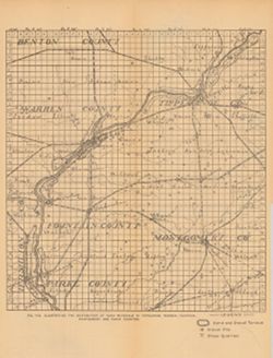
- Subject:
- Topical Subject: Road materials, Geographic Subject: Warren County (Ind.), Topical Subject: Quarries and quarrying, Topical Subject: IGS Annual Reports, Geog...
- Publisher:
- Indiana. Department of Geology and Natural Resources
- Date Created:
- 1906
- Identifier:
- VAC3073-M-00382
- Genre:
- Geological maps
- Geographic Location:
- Coordinates: W0872701 W0864139 N0403347 N0395159
- Related URL:
- Catalog URL: https://iucat.iu.edu/catalog/18299027
- Abstract:
- Shows sand and gravel terraces, gravel pits, and stone quarries. At head of title: Fig. 41B. Detached from: The roads and road materials of a portion of s...
- Call Number:
- G4093.T4H5 1905 .I4
- Caption:
- Imprint: [Indianapolis] : [Indiana Dept. of Geology and Natural Resources], [1906]
- Physical Description:
- Scale: Approximately 1:284,000 and Dimensions: 36 x 27 cm
- Alternate Identifier:
- Title Control Number: a18299027 and Alternate ID: 390726IP
- Persistent URL:
- https://purl.dlib.indiana.edu/iudl/images/VAC3073/VAC3073-M-00382
- Provenance:
- 30th Annual Report (1905) / Indiana. Department of Geology and Natural Resources.
-
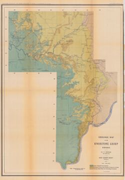
- Subject:
- Topical Subject: Mines and mineral resources, Topical Subject: Geology, Geographic Subject: Indiana, Topical Subject: Geology, Stratigraphic, and Topical Sub...
- Creator:
- Newsom, John F. (John Flesher), 1869-1928
- Publisher:
- Indiana. Department of Geology and Natural Resources
- Date Created:
- 1902
- Identifier:
- VAC3073-M-00381
- Genre:
- Geological maps
- Geographic Location:
- Coordinates: W0863410 W0853500 N0390430 N0375720
- Related URL:
- Catalog URL: https://iucat.iu.edu/catalog/16077083
- Abstract:
- Relief shown by contour lines. "Plate III." Detached from: A geologic and topographic section across Southern Indiana / by J. F. Newsom. In Indi...
- Call Number:
- G4091.C5 1901 .N43
- Caption:
- Imprint: [Indianapolis, Ind.] : [Indiana Department of Geology and Natural Resources], [1901] and Imprint: Indianapolis, Ind. : Wm. B. Burford, [1902]
- Physical Description:
- Scale: Scale approximately 1:190,080. 3 miles = 1 in. and Dimensions: 69 x 49 cm, on sheet 76 x 52 cm
- Alternate Identifier:
- Title Control Number: a16077083 and Alternate ID: 390726IP
- Persistent URL:
- https://purl.dlib.indiana.edu/iudl/images/VAC3073/VAC3073-M-00381
- Provenance:
- 26th Annual Report (1901) / Indiana. Department of Geology and Natural Resources.
-
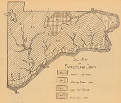
- Subject:
- Topical Subject: Loam soils, Geographic Subject: Switzerland County (Ind.), and Topical Subject: IGS Annual Reports
- Creator:
- Ward, L. C. (Louis Clinton), 1878-1931
- Publisher:
- Indiana. Department of Geology and Natural Resources
- Date Created:
- 1908
- Identifier:
- VAC3073-M-00370
- Genre:
- Thematic maps
- Geographic Location:
- Coordinates: W0851212 W0844704 N0385545 N0384115
- Related URL:
- Catalog URL: https://iucat.iu.edu/catalog/18349086
- Abstract:
- Detached from: A soil survey of Decatur, Jennings, Jefferson, Ripley, Dearborn, Ohio, and Switzerland counties, Indiana / L.C. Ward. In Indiana Dept. of Geol...
- Call Number:
- G4093.S9J3 1907 .S6
- Caption:
- Imprint: [Indianapolis] : [Indiana Department of Geology and Natural Resources], [1908]
- Physical Description:
- Scale: Scale not given. and Dimensions: on sheet 21 x 24 cm
- Alternate Identifier:
- Title Control Number: a18349086 and Alternate ID: 390726IP
- Persistent URL:
- https://purl.dlib.indiana.edu/iudl/images/VAC3073/VAC3073-M-00370
- Provenance:
- 32nd Annual Report (1907) / Indiana. Department of Geology and Natural Resources.
-
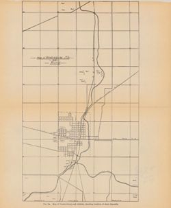
- Subject:
- Geographic Subject: Veedersburg City Region (Ind.), Topical Subject: Shale, Geographic Subject: Fountain County (Ind.), and Topical Subject: IGS Annual Reports
- Publisher:
- Indiana. Department of Geology and Natural Resources
- Date Created:
- 1905
- Identifier:
- VAC3073-M-00371
- Genre:
- Geological maps
- Geographic Location:
- Coordinates: W0871723 W0871347 N0401012 N0400505
- Related URL:
- Catalog URL: https://iucat.iu.edu/catalog/18282209
- Abstract:
- Caption title: Map of Veedersburg and vicinity, showing the location of shale deposits. "Fig. 2a." Detached from: The clays and clay industries ...
- Call Number:
- G4094.V3H5 1904 .M37
- Caption:
- Imprint: [Indianapolis] : [Wm. B. Burford], [1905] and Imprint: [Indianapolis] : [Indiana Department of Geology and Natural Resources], [1905]
- Physical Description:
- Dimensions: on sheet 27 x 23 cm and Scale: Approximately 1:34,250
- Alternate Identifier:
- Alternate ID: 390726IP and Title Control Number: a18282209
- Persistent URL:
- https://purl.dlib.indiana.edu/iudl/images/VAC3073/VAC3073-M-00371
- Provenance:
- 29th Annual Report (1904) / Indiana. Department of Geology and Natural Resources.
-
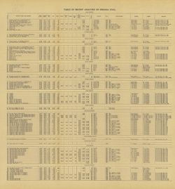
- Subject:
- Geographic Subject: Clay County (Ind.), Topical Subject: IGS Annual Reports, Topical Subject: Coal, Topical Subject: Mines and mineral resources, Geographic ...
- Creator:
- Ashley, Geo. H. (George Hall), 1866-1951
- Publisher:
- Indiana. Department of Geology and Natural Resources
- Date Created:
- 1909
- Identifier:
- VAC3073-M-00359
- Genre:
- Tables (Data) and Charts
- Related URL:
- Catalog URL: https://iucat.iu.edu/catalog/4022271
- Abstract:
- Detached from: The coal deposits of Indiana : a supplemental report to the one issued in 1898 / by Beorge H. Ashley. In Indiana Department of Geology and Nat...
- Call Number:
- QE109 .A2 1908 map p144
- Caption:
- Imprint: Indianapolis : 1909
- Physical Description:
- Dimensions: 40 x 38 cm
- Alternate Identifier:
- Title Control Number: 390726IP
- Persistent URL:
- https://purl.dlib.indiana.edu/iudl/images/VAC3073/VAC3073-M-00359
- Provenance:
- 33rd Annual Report (1908) / Indiana. Department of Geology and Natural Resources.
-
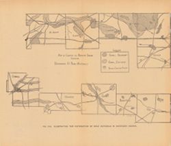
- Subject:
- Topical Subject: Sand and gravel plants, Topical Subject: IGS Annual Reports, Topical Subject: Road materials, and Geographic Subject: Indiana
- Publisher:
- Indiana. Department of Geology and Natural Resources
- Date Created:
- 1906
- Identifier:
- VAC3073-M-00360
- Genre:
- Thematic maps and Geological maps
- Geographic Location:
- Coordinates: W0864500 W0844800 N0414500 N0402100
- Related URL:
- Catalog URL: https://iucat.iu.edu/catalog/18299087
- Abstract:
- Alternate title: Illustrating the distribution of road materials in northern Indiana. At head of alternate title: Fig. 23A. Shows areas of abundant and suffi...
- Call Number:
- G4091.H5 1905 .M37
- Caption:
- Imprint: [Indianapolis] : [Indiana Dept. of Geology and Natural Resources], [1906]
- Physical Description:
- Scale: Scale not given. and Dimensions: on sheet 23 x 27 cm
- Alternate Identifier:
- Title Control Number: a18299087 and Alternate ID: 390726IP
- Persistent URL:
- https://purl.dlib.indiana.edu/iudl/images/VAC3073/VAC3073-M-00360
- Provenance:
- 30th Annual Report (1905) / Indiana. Department of Geology and Natural Resources.
-

- Subject:
- Topical Subject: Limestone, Geographic Subject: Owen County (Ind.), Geographic Subject: Bloomington Region (Ind.), Geographic Subject: Greene County (Ind.), ...
- Creator:
- Indiana. Department of Geology and Natural Resources
- Publisher:
- Indiana. Department of Geology and Natural Resources
- Date Created:
- 1914
- Identifier:
- VAC3073-M-00351
- Genre:
- Topographic maps, Quadrangle maps, and Geological maps
- Geographic Location:
- Coordinates: W0864500 W0863000 N0391500 N0390000
- Related URL:
- Catalog URL: https://iucat.iu.edu/catalog/4896690
- Abstract:
- Relief shown by contours and spot heights. Contour interval 20 feet. Shows limestone locations in a portion of Monroe County and small portions of Owen and G...
- Call Number:
- G4093 .M7C5 1914 .I6
- Caption:
- Imprint: [Indianapolis] : Indiana Dept. of Geology [and Natural Resources], [1915] and Imprint: [Indianapolis] : [Wm. B. Burford], [1915]
- Physical Description:
- Dimensions: 45 x 35 cm and Scale: 1:62,500
- Alternate Identifier:
- Title Control Number: a4896690 and Alternate ID: 390726IP
- Persistent URL:
- https://purl.dlib.indiana.edu/iudl/images/VAC3073/VAC3073-M-00351
- Provenance:
- 39th Annual Report (1914) / Indiana. Department of Geology and Natural Resources.
-
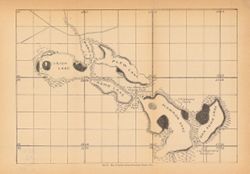
- Subject:
- Geographic Subject: Bass Lake (Starke County, Ind. : Lake), Topical Subject: IGS Annual Reports, Geographic Subject: Starke County (Ind.), and Topical Subjec...
- Publisher:
- Indiana. Department of Geology and Natural Resources
- Date Created:
- 1901
- Identifier:
- VAC3073-M-00348
- Genre:
- Maps
- Geographic Location:
- Coordinates: W0863646 W0863409 N0411431 N0411221
- Related URL:
- Catalog URL: https://iucat.iu.edu/catalog/18189994
- Abstract:
- Depth shown by soundings. Title from caption. Detached from: The lakes of northern Indiana and their associated marl deposits / W. S. Blatchley and Geo. ...
- Call Number:
- G4092.B35 1900 .M37
- Caption:
- Imprint: [Indianapolis] : [Indiana, Department of Geology and Natural Resources], [1901] and Imprint: [Indianapolis] : [Wm. B. Burford], [1901]
- Physical Description:
- Dimensions: 22 x 21 cm and Scale: Approximately 1:21,500
- Alternate Identifier:
- Alternate ID: 390726IP and Title Control Number: a18189994
- Persistent URL:
- https://purl.dlib.indiana.edu/iudl/images/VAC3073/VAC3073-M-00348
- Provenance:
- 25th Annual Report (1900) / Indiana. Department of Geology and Natural Resources.
-
- Subject:
- Geographic Subject: Vigo County (Ind.), Topical Subject: Geology, Stratigraphic, Topical Subject: Coal reserves, Topical Subject: IGS Annual Reports, and Top...
- Publisher:
- Indiana. Department of Geology and Natural Resources
- Date Created:
- 1899
- Identifier:
- VAC3073-M-00303
- Genre:
- Geological cross-sections and Geological maps
- Geographic Location:
- Coordinates: W0872400 W0865700 N0393900 N0393000
- Related URL:
- Catalog URL: https://iucat.iu.edu/catalog/18214647
- Abstract:
- Relief shown by profile. Includes map showing locations of coal fields in Vigo County, Indiana, as well as 2 geological cross sections along the north and so...
- Call Number:
- G4093.V5H9 1898 .C63
- Caption:
- Imprint: [Indianapolis] : [Indiana Department of Geology and Natural Resources], [1899]
- Physical Description:
- Scale: Approximately 1:63,360. Vertical scale varies and Dimensions: 23 x 27 cm
- Alternate Identifier:
- Title Control Number: a18214647 and Alternate ID: 390726IP
- Persistent URL:
- https://purl.dlib.indiana.edu/iudl/images/VAC3073/VAC3073-M-00303
- Provenance:
- 23rd Annual Report (1898) / Indiana. Department of Geology and Natural Resources.
-
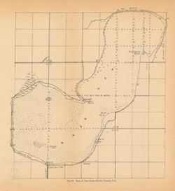
- Subject:
- Geographic Subject: Irish Lake (Ind.), Geographic Subject: Kosciusko County (Ind.), Geographic Subject: Big Barbee Lake (Ind.), Topical Subject: IGS Annual R...
- Publisher:
- Indiana. Department of Geology and Natural Resources
- Date Created:
- 1901
- Identifier:
- VAC3073-M-00295
- Genre:
- Maps
- Geographic Location:
- Coordinates: W0854443 W0854115 N0411820 N0411636
- Related URL:
- Catalog URL: https://iucat.iu.edu/catalog/18189963
- Abstract:
- Shows Barbee chain of lakes and local clubs and parks. Names of lakes as shown on map: Irish, Mabie (Sawmill), Plew (Sechrist), Kuhn (Little Barbee), Hammon ...
- Call Number:
- G4092.B3 1900 .M3
- Caption:
- Imprint: [Indianapolis] : [Dept. of Geology and Natural Resources], [1901]
- Physical Description:
- Dimensions: 22 x 32 cm
- Alternate Identifier:
- Title Control Number: a18189963 and Alternate ID: 390726IP
- Persistent URL:
- https://purl.dlib.indiana.edu/iudl/images/VAC3073/VAC3073-M-00295
- Provenance:
- 25th Annual Report (1900) / Indiana. Department of Geology and Natural Resources.
